We found 186094 price guide item(s) matching your search
There are 186094 lots that match your search criteria. Subscribe now to get instant access to the full price guide service.
Click here to subscribe- List
- Grid
-
186094 item(s)/page


Lot 73
Robert Adam FRSE, FRS, FSA (Scot), FSA, FRSA (Scottish 1728-1792) Design for Altering the South Front of Blackadder House, the Seat of Alexander Boswall Esq Signed, dated 1784, titled, and with a scale Pen and black ink, grey wash and watercolour within black framing lines 35 x 51cm; 13¾ x 20in Provenance: Houstoun-Boswall Collection; By descent Blackadder House, near Allanton, formed part of the medieval Blackadder estate positioned on the Scottish border. Robert Adam's designs, dating to c.1784, were made for Alexander Boswell (alternatively spelt Boswall). The house, to which Adam's scheme relates, was thought to have been originally built around 1764, possibly incorporating part of an earlier medieval structure in the process. Adam's designs propose a number of alterations with the aim of regularising the overall plan, with additions to the front and side elevations. As the house was demolished in 1925, it is difficult to ascertain whether Adam's scheme was ever executed. The Sir John Soane's Museum, London contains a number of Adam's designs for the house, including an earlier, less worked up, version of the south front (SM Adam volume 32/77).
![* Lancashire. Saxton (Christopher & Hole G.), Lancastriae comitatus Palatinus olim pars Brigantum, [1637], hand coloured](https://cdn.globalauctionplatform.com/cfecfaca-a1f0-4f8a-84de-ab66012f1173/8a2616b6-5579-47d0-abab-ab680118c229/468x382.jpg)
Lot 106
* Lancashire. Saxton (Christopher & Hole G.), Lancastriae comitatus Palatinus olim pars Brigantum, [1637], hand coloured engraved map, large strapwork cartouche, compass rose and mileage scale, slight creasing, 300 x 310 mm, mounted, framed and glazed, together with Saxton (Chrisopher & Kip W.). Wiltoniae Comitatus herbida Planieie nobilis vulgo Willshire pars olim Belgarum, circa 1610, hand coloured engraved map, 285 x 375 mm, mounted, framed and glazed, with Morden (Robert). Somersetshire, circa 1701, hand coloured engraved map, old folds, 175 x 210 mm, mounted, framed and glazed, plus Badeslade (T. & Toms W. R. ). A map of Oxfordshire North West from London [and] A Map of Kent South East from London, A Map of Leicestershire North of London, 1742, together three hand coloured engraved maps, each approximately 150 x 150 mm, mounted, framed and glazed and Kitchin (Thomas). Cornwall from an actual survey and regulated by Astronl. Observatns., circa 1760, hand coloured engraved map, inset map of the Isles of Scilly, trimmed to neatline and tipped on to later paper, 195 x 230 mm, mounted, framed and glazed, with another seven county, regional and road maps, with examples by Cary, Owen & Bowen, Senex and Luffman, various sizes and condition, all framed and glazed (Qty: 14)
![Lancashire. Speed (John), The Countie Pallatine of Lancaster described and divided into Hundreds, [1611 or later], engraved m](https://cdn.globalauctionplatform.com/cfecfaca-a1f0-4f8a-84de-ab66012f1173/fde4aa37-7b5c-4058-99c6-ab680118c2e5/468x382.jpg)
Lot 107
Lancashire. Speed (John), The Countie Pallatine of Lancaster described and divided into Hundreds, [1611 or later], engraved map with early hand colouring, inset town plan of Lancaster, strapwork cartouche and mileage scale, decorated with eight portraits of Plantagenet Kings and Queens, central fold cracked and partially repaired on verso, trimmed to neatline and laid on near contemporary stiff paper, 380 x 500 mm (Qty: 1)
Lot 112
London. Faden (William), The Country Twenty-five Miles round London planned from a scale of one mile to an Inch, 3rd edition, 1802, engraved map with contemporary outline colouring, sectionalised and laid on linen and presented on four sheets, 1040 x 1240 mm, card chemise, contained in a contemporary marbled slipcase with printed label to upper cover, worn and rubbed, together with Luffman (John). The Seat of War between Russia and France, circa 1812, engraved folding map on two conjoined sheets with contemporary hand colouring, short split along one fold, 355 x 405 mm, contained in a contemporary paper slipcase with printed label to upper cover, worn and cracked at extremities (Qty: 2)NOTESFirst described item. Howgego, no. 188, state 6
Lot 113
London. Mogg (E. S.), Modern London and its Environs, circa 1846, engraved map with contemporary outline colouring, sectionalised and laid on linen, 530 x 820 mm, together with Stanford (Edward, publisher). A Map of the Environs of London extending Twenty-five Miles fr. the Metropolis, circa 1870, lithographic map with contemporary outline colouring, sectionalised and laid on linen, slight overall toning, 910 x 930 mm, retaining one cloth board, with D avies (Benjamin Rees). Davies's New Map of the British Metropolis. The Boundaries of the Boroughs, County Court Districts Railways, and Modern Improvements, published Edward Stanford, 1889, lithographic map with contemporary outline colouring, dust soiled and torn horizontally in half along old linen, overall size 660 x 940 mm, retaining one cloth board, plus an early 20th century Ordnance Survey map of part of Shropshire on a scale of six inches to the mile, heavily stained, marbled endpapers, plus a mid 20th century colour printed map on silk of the coastline of Japan, 1200 x 1300 (Qty: 5)NOTESThe first item described. Howgego number 390, state 2 (a).
![* Oxfordshire. Plot (Robert), The Map of Oxfordshire, [1677], [1677], hand coloured engraved map, decorative cartouche, milea](https://cdn.globalauctionplatform.com/cfecfaca-a1f0-4f8a-84de-ab66012f1173/dd57dfdd-a9ae-4cda-8ec7-ab680118d15e/468x382.jpg)
Lot 129
* Oxfordshire. Plot (Robert), The Map of Oxfordshire, [1677], [1677], hand coloured engraved map, decorative cartouche, mileage scale, table of explanation and compass rose, old folds, slight creasing, slight overall toning, 500 x 480 mm, mounted, framed and glazed (Qty: 1)NOTESCreated by the first keeper of the Ashmolean Museum of Oxford, the map is decorated with 172 coats of arms of the county's gentry, Oxford colleges, the city and the four county towns. One of the most decorative maps of Oxfordshire ever produced.
Lot 130
* Pembroke. Saxton (Christopher), Penbrok Comitat qui inter Meridionales Cambriae..., 1587, engraved map with contemporary hand colouring and some later enhancement, large strapwork cartouche surmounted by the royal crest, mileage scale surmounted by dividers and the coat of arms of Thomas Seckford, one small printers fold, 355 x 470 mm, mounted, framed and glazed (Qty: 1)NOTESThe first engraved county map of Pembroke, in very good condition

Lot 147
* Scotland. Blaeu (J. & Pont T.), Sterlinensis Praefectura . Sterlin-Shire , circa 1655, engraved map with contemporary outline colouring, large decorative cartouche and mileage scale, slight staining, 410 x 525 mm, Latin text on verso, framed and double glazed, together with De Wit (Frederick). Scotia Regnum divisum in Partem Septentrionalem et Meridionalem..., circa 1690, hand coloured engraved map, slight spotting and creasing, occasional later underlining in faint red crayon of place names, 575 x 510 mm, mounted, framed and glazed (Qty: 2)
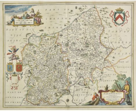
Lot 148
Shropshire & Staffordshire. Jansson (Jan), Salopiensis comitatus cum Staffordiensi. Shropshire & Staffordshire, circa 1650, engraved map with contemporary outline colouring, decorative cartouche and mileage scale, central fold partially split and repaired on verso, 430 x 535 mm, Dutch text on verso, together with Greenwood (C. & J.). Map of the County of Salop from an actual Survey made in the Years 1826 & 1827, published 1830, engraved map with contemporary hand colouring, large calligraphic cartouche, compass rose, tables of reference and explanation, uncoloured vignette of Shrewsbury, very slight offsetting, occasional marginal closed tears, 580 x 690 mm (Qty: 2)

Lot 150
Shropshire. Saxton (Christopher & Lea Philip), Shropshire accuratly drawen and sett forth by C S corrected with some additions by P Lea, circa 1693, engraved map with early hand colouring, inset town plan of Shrewsbury, classical 'altar' cartouche, mileage scale, slight overall toning, 390 x 510 mm (Qty: 1)

Lot 152
Shropshire. Schenk ( Pieter & Valk Gerard), Salopiensis comitatus cum Staffordiensi. Shropshire & Staffordshire, Amsterdam, circa 1700, engraved map with contemporary hand colouring, cartouche and mileage scale are uncoloured, 430 x 535 mm, together with Saxton (Christopher & Lea Philip). Shropshire accuratly drawen and sett forth by C. S. corrected with some additions by P Lea, published G. Willdey, circa 1720, hand coloured engraved map, inset town plan of Shrewsbury, trimmed to neatline with slight loss to printed border, laid on later paper, 390 x 510 mm, with Speed (John). Shropshire described. The Sittuation of Shrowesbury shewed with the armes of thos Earles and other memorable things observed, published Henry Overton, [1713 - 1743], engraved map with contemporary outline colouring, inset town plan of Shrewsbury, large strapwork cartouche and mileage scale, large margins, 380 x 505 mm, plus another six large maps of Staffordshire including examples by Kitchin, Cary, Arrowsmith. Dix, Weller (two sheets and Smith, various sizes and condition (Qty: 9)
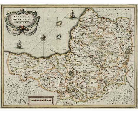
Lot 154
* Somerset. Jansson (Jan), Comitatus Somersettensis, Somerest-Shire, circa 1638, hand coloured engraved map, ornate strapwork cartouche and mileage scale, compass rose and numerous rhumb lines, slight text show-through, 385 x 505 mm, mounted, framed and double glazed, German text on verso, together with Saxton (Christopher & Kip William). Somersettensis Comitatus vulgo Somersett Shyre qui olim pars suit Belgarum, [1610], hand coloured engraved map, large strapwork cartouche and mileage scale, 285 x 390 mm, mounted, framed and glazed (Qty: 2)NOTESThe first described item is in the scarce 'pre-atlas' state printed before the addition of the six coats of arms and a re-working of the title cartouche.
Lot 159
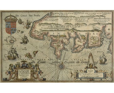
* Waghenaer (Lucas Janszoon). Zee Caerte van Engelants Eijndt, Alsoe hemtselsde Landt verthoont beginnede van Sorlinges tot Pleymondt, [1586], engraved hand coloured sea-chart of Cornwall, elaborate ornamental title cartouche, separate scale of distance surmounted by open dividers, royal crest, compass rose and rhumb lines, decorated with several sailing ships, sea monsters and land animals, 330 x 520 mm, Latin text to verso, mounted, framed and double glazed (Qty: 1)NOTESFrom the Latin edition of Waghenaer’s landmark atlas of sea charts “Spieghel der Zeervaerdt”, or the 'Mirror of the Sea'. The atlas, which was originally published in Dutch in 1584, was translated into Latin in 1586.
![* [Ireland]. 'A Survey of the the Domain, Lands, and Bogs of Clooneen ... Part of the Estate of Thomas Berry Esq. Situate in](https://cdn.globalauctionplatform.com/cfecfaca-a1f0-4f8a-84de-ab66012f1173/13f42874-eb26-4312-97b9-ab6801190640/468x382.jpg)
Lot 208
* [Ireland]. 'A Survey of the the Domain, Lands, and Bogs of Clooneen ... Part of the Estate of Thomas Berry Esq. Situate in the Kings County. Laid down by a scale of 20 Perches in one inch ... by Mich[ael] Cuddehy', 1796, estate plan, watercolour on vellum, soiling, a few small holes, creased from folding, 35.5 x 70 cm, together with: Crewe (John, 1st Baron Crewe, 1598-1679). Document signed, 27 December 1670, leasing marshland to Henry Moore of London, manuscript in brown ink on vellum, seal tear to corner (backed with paper verso), soiling, 22 x 28.5 cm, and 3 others including 2 vellum documents (large indenture dated 1679, and a 16th-century English document in Latin) (Qty: 5)NOTESProvenance (first item): Sotheby's, 25 January 1985, lot 178 (paid £35), with envelope. Crewe, of Steane in Northamptonshire, entered parliament in 1624 as member for Amersham. 'During the Personal Rule Crewe was charged with neglect over the collection of Ship Money, and accused of maintaining puritan preachers. Nevertheless, he was appointed to an honorary post at Court in 1638, and Charles I was later reported to have said that "Crewe, though he be against me, is an honest man". As a nominal Presbyterian he supported Parliament in the First Civil War, sitting for Brackley in the Long Parliament until Pride’s Purge' (History of Parliament, online).

Lot 69
* Bedfordshire. Speed (John), Bedford Shire and the situation of Bedford described, with the armes of thos Honorable familyes that have borne ye titles of Dukes and Earls thereof, published Roger Rea [1662], hand coloured engraved map, inset town plan of Bedford, large strapwork cartouche and mileage scale, 380 x 510 mm, mounted, framed and double glazed, English text on verso (Qty: 1)
Lot 79
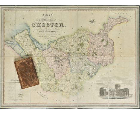
Cheshire. Swire (W. & Hutchings W.F.), A Map of the County Palatine of Chester, Divided into Hundreds & Parishes from an accurate survey, made in the years 1828 & 1829, published Henry Teesdale, 1830, large scale map engraved by J. Dower with bright contemporary hand colouring, sectionalised and laid on linen, calligraphic title, compass rose, table of reference and an uncoloured vignette of the south west view of Chester cathedral, slight offsetting, edged in green silk, marbled endpapers with decorative book-plate of John Ireland Blackburne and dated 1874, 960 x 1320 mm, contained in a contemporary marbled calf book-box, box heavily worn and frayed (Qty: 1)

Lot 84
* East Anglia. Blaeu (Johannes), Regiones Inundatae in Finibus Comitatus Norfolciae, Suffolciae, Cantabrigiae, Huntingtoniae, Northamtoniae, et Lincolniae, Amsterdam, circa 1646, hand coloured engraved map, ornate strapwork cartouche and mileage scale, 435 x 545 mm, mounted, framed and double glazed, French text on verso (Qty: 1)
Lot 87
* England and Wales. Ogilby (John), A New Map of the Kingdom of England & Dominion of Wales. Whereon are Projected All ye Principal Roads Actually Measured & Delineated by John Ogilby Esq, [1676], hand coloured map, engraved by James Moxon, ornate strapwork cartouche and mileage scale, inset table or 'Catalog' of roads to the upper right, 380 x 500 mm, mounted, framed and glazed (Qty: 1)NOTESR. W. Shirley. Printed Maps of the British Isles 1650 - 1750. Ogilby 1 state 2 lacking the spire and tower symbols used to denote towns and represented by simple circles but now with ships decorating the sea. Published as the key map to John Ogilby's 'Britannia'.

Lot 98
* Gloucestershire. Saxton (Christopher & Lea Philip), Glocester-Shire described by C. S. corrected and amended with many additions by P. Lea, circa 1693, hand coloured engraved map, inset town plans of Bristol and Gloucester, strapwork cartouche and mileage scale surmounted by dividers, the principal towns ringed in red, 390 x 505 mm, mounted, framed and glazed (Qty: 1)NOTESAlthough printed from Christopher Saxton's original copper plates, Lea has amended and altered the plate by adding town plans, heraldic shields and roads, taken variously from the maps of John Speed and John Ogilby.

Lot 143
WW2 SAS attributed ‘Zones of France’ cotton printed escape map.A scarce, example printed on cotton and not the more common silk. This single sided colour map is titled “Zones of France” and was printed in March 1944. Second Edition 1:2000.000 scale. GC. Part of the Fred Casey SAS ArchivePLEASE NOTE SILK MAP ONLY IN THIS LOT FS KNIFE IS LOT 142


-
186094 item(s)/page