We found 186097 price guide item(s) matching your search
There are 186097 lots that match your search criteria. Subscribe now to get instant access to the full price guide service.
Click here to subscribe- List
- Grid
-
186097 item(s)/page


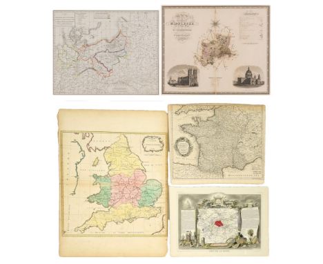
Lot 581
Five (5) European maps, including French Napoleonic and English. 1st item: Map of Theater of War and French and Allied Saxon Marches in Prussia and Poland during the Campaigns of 1806 and 1807 (Carte de Theatre de la Guerre et Marches des Armees Francaises et Allies en Saxe en Prusse et en Pologne pendant les Campagnes de 1806 et 1807) engraved by Jean Baptiste Pierre Tardieu, circa 1807. Copper plate engraving depicting the areas of Europe involved in the Napoleonic War of the Fourth Coalition, October 1806-July 1807, including with hand colored elements detailing the routes of the different armies with French text. Title and tables, top left and center, scale of miles, lower center. Map surrounded by scale notations and double line border. Previously mounted to mat with old archival paper tape. Image - 16 3/8" H x 20 5/8" W. Sheet - 17 7/8" H x 22 1/2" W. Mat - 23 3/8" H x 27 1/4" W. 2nd item: The County of Middlesex, from an Actual Survey made in the Years 1819 & 1820 by C. & I. Greenwood, engraved by J. & J. Neele, 1829. Published by the proprietors C. Greenwood & Co., London. Copper plate engraving with hand coloring depicting Middlesex, a historic county in southeast England almost entirely within the wider urbanized area of London, center, with vignettes of Westminster Abbey, lower left, and St. Paul's Cathedral, lower right. Title, top left, compass rose, top center, Explanation and scale of miles, top right, Reference to the Hundreds, lower center. Map surrounded by border with scale notations. Housed in a mat with plastic covering. Image - 21" H x 25 3/4" W. Sight - 21 1/4" H x 26" W. Mat - 26 7/8" H x 32 3/8" W. 3rd item: "Carte D'Angleterre 1754" by Jean Palairet. Colored map of England and Wales with French identifications. Counties, cities, towns, rivers, bodies of water, and points of interest marked. Ireland, Scotland, and France also present. Decorative title cartouche with scale of miles, top right. Image - 20-1/4" H x 20-5/8" W. Sheet - 28-3/4" H x 21-1/4" W. 4th item: "A Map of France with the Dominions" by Richard William Seale, for "Mr. Tindal's Continuation of Mr. Rapins History", 1750. Uncolored map of France and surrounding territories, including parts of England, Germany, and Spain, with regions, cities, towns, rivers, bodies of water, mountain ranges, and points of interest marked. Decorative title cartouche, middle left. Explanation and 2 scales of miles, lower right. Image - 15" H x 18-1/2" W. Sheet - 16" H x 19-1/4" W. 5th item: "Dept de la Seine" by Victor Levasseur, engraved by Laguillermie and Rainaud, for "Atlas National Illustre des 86 Departments et des Possessions De La France", 1833. Colored map of Paris, with surrounding regions, including Versailles, some colored elements. Surrounding map are sections of text describing statistics, curiosities and celebrities, and products and commerce. Images of local heroes, products, landscapes, dress, and coat of arms with colored elements above and below map. Image - 12" H x 17-3/8" W. Sheet - 14-1/8" H x 20-1/8" W. All items mid 18th/second quarter 19th century. CONDITION: 1st item: Overall good condition with foxing spots, tears. Residue from old archival paper tape to each corner. Sheet has been cut down. 2nd item: Overall good condition with toning/areas of acid burn, foxing spots. Not examined outside of mat. 3rd item: Impression of other map visible lower right. Areas of toning on surface, largest area 1/2", lower middle left. Slight toning around edges. Loss, rips, tears, to edges of sheet. 4th item: 1-5/8" line of toning, top left. Slight toning around edges, toning extends 1-5/8" on top edge. 5th item: 2 brown stains, 3/8" top middle right, and 1/8" middle left. Slight toning around edges.
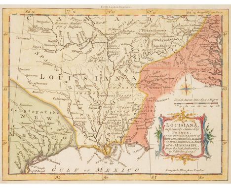
Lot 582
Louisiana, as formerly claimed by France, now containing part of British America to the East in Spanish America to the West of Mississippi map, by Thomas Kitchin, published in the London Magazine, for R. Baldwin, Vol. 34, opp. pg. 276, June 1765. Copper plate engraving with hand coloring depicting the Louisiana territory, center, and the surrounding areas including the Country of New Mexico, lower left, and Native American territory, including Cherokees and Creeks, designated as "Upper Cherakees [sic]", "Lower Cherakees [sic]", "Upper Creeks", and "Lower Creeks", along with other tribes, right. Cities and towns, including New Orleans, bodies of water, and other points of interest including "Country full of Mines" are labeled. Compass rose, scale of miles, and title cartouche, lower right. Map surrounded by scale notations and line border. Secured to a mat with two pieces of white archival tape, top left and right edge. Sheet - 8 3/8" H x 9 5/8" W. Sight - 7 1/4" H x 9 3/8" W. Mat - 11 1/8" H x 13 3/4" W. Third quarter 18th century. CONDITION: Light toning, few minute foxing spots. Few tears, largest 1/4", to fold lines. Two areas of loss, largest 1 1/4" x 1/4", to corners of sheet. Pencil inscription en verso. David Lloyd Swift ink stamp indicates that the map was professionally deacidified in March 1998.

Lot 583
Map of the State of Texas, by James Hamilton Young, engraved by J.L. Hazard, published in A NEW UNIVERSAL ATLAS, Charles Desilver, Philadelphia, 1856. Steel plate engraving with hand coloring depicting the territory of Texas, center, and the surrounding areas including Mexico, lower left, and the Indian Territory, Arkansas, and Louisiana, top right. Cities and towns, including Austin and Houston, railroads, bodies of water, counties, and other points of interest including Apache, Comanchees, and Lippan lands, important battlefields in both the Texas Revolution and the Mexican-American War, are labelled. Inset maps of Northern Texas and Map of Galveston Bay, top and lower left. List of railroads, title, and scale of miles, lower right. Explanation and population tables listed by race, center left. Map surrounded by scale notations and a decorative border. Photocopy of the atlas cover, en verso. Encapsulated (not laminated) in a plastic archival sleeve. Sheet - 13 3/4" H x 16 3/4" W. Sleeve - 14 1/2" H x 17 5/8" W. Mid 19th century. CONDITION: Light toning/acid burn, few minute foxing spots visible en verso. David Lloyd Swift label indicates that the map was professionally deacidified on March 14, 1989.
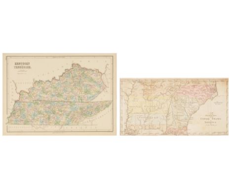
Lot 584
Two (2) Southern Maps. 1st item: Abraham Bradley, Jr. (American, 1767-1838), MAP OF THE SOUTHERN PARTS OF THE UNITED STATES OF AMERICA, engraved for The American Gazetteer by Jedidiah Morse, published by S. Hall, Boston, 1797. Copper plate engraving with hand coloring of the Southern United States and Native American territories east of the Mississippi River including Part of Kentucky, Part of Virginia, Tennessee, North Carolina, Georgia Western, South Carolina, Chactaws [sic] Territory Georgia, West Florida, and East Florida, prior to the establishment of Mississippi and Alabama in 1817 and the Louisiana Purchase. Cities from Norfolk to St. Augustine, towns, districts, including the Mero District near Nashville, bodies of water, and other areas of interest, including the locations of Native American tribes, including the Upper Creeks and Cherokees in eastern Kentucky, are labelled. Title and scale of miles, center to lower right. Map surrounded by scale notations and a line border. Encapsulated (not laminated) in a plastic archival sleeve and secured to a mat. Sight - 8 1/8" H x 15 1/4" W. Mat - 14 1/4" H x 20 1/4" W. Late 18th century. 2nd item: John Bartholomew (Scottish, 1831-1893), KENTUCKY AND TENNESSEE, drawn and engraved by John Bartholomew, for Black's Atlas of North America, published by Adam and Charles Black, Edinburgh, 1856. Steel plate engraving with printed coloring depicting Kentucky and Tennessee and the surrounding areas with cities and towns, including Nashville and Knoxville, counties, bodies of water, roads, and other areas of interest labelled. Title and scale of miles, top left. Map surrounded by scale notations and triple line border. Encapsulated (not laminated) in a plastic archival sleeve and secured to a mat. Sheet - 12 1/4" H x 16 3/4" W. Mat - 18 3/8" H x 24 3/8" W. Mid 19th century. CONDITION: 1st item: Areas of toning/acid burn, foxing spots, largest 1/2". 1/4" x 2 1/2" area of loss, lower right corner of sheet. Areas of tape repair, largest 1 3/4" x 3/4", visible en verso. Possible pencil inscriptions en verso. Map with paper backing. David Lloyd Swift label indicates that the map was professionally encapsulated, cleaned, and deacidified in 1998. 2nd item: Areas of toning, minute foxing spots. Pencil inscriptions, en verso. David Lloyd Swift ink stamp label indicates that the map was professionally deacidified.

Lot 585
THE STATE OF VIRGINIA map, engraved by Benjamin Tanner, for The American Atlas, published by John Reid, New York, 1796. Copper plate engraving with hand coloring depicting an early map of Virginia with cities and towns, including Richmond, counties, roads, rivers, lakes, islands, harbors, bays, court houses, along with topographical details labelled. Title cartouche and scale of miles, top left. Map surrounded by scale notations and triple line border. Encapsulated (not laminated) in a plastic archival sleeve and secured to a mat. Plate - 14 1/4" H x 19 1/2" W. Sheet - 16 3/8" H x 20 1/8" W. Sight - 15" H x 19 3/4" W. Mat - 20" H x 26" W. Late 18th century. CONDITION: Overall good condition with toning, foxing spots, largest 1/4". David Lloyd Swift ink stamp label indicates that the map was professionally deacidified.
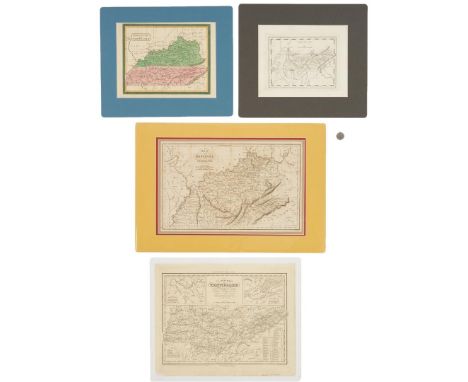
Lot 586
Two (2) Maps of Tennessee, two (2) maps of Tennessee and Kentucky, 4 items total. 1st item: Tennessee map, from American Pocket Atlas, published by Mathew Carey, Philadelphia, 1816. Copper plate engraving depicting Tennessee, center and surrounding areas, with cities and towns, including Knoxville, Clarksville, and Nashvill [sic], roads, bodies of water, and other points of interest, including Cragfont, the Home of General James Winchester, labelled. Title and scale of miles, top center. Map surrounded by scale notations and line border. Encapsulated (not laminated) in a plastic archival sleeve and secured to a mat. Plate - 6 5/8" H x 8 1/2" W. Sheet - 8 5/8" H x 10 5/8" W. Sight - 8 1/8" H x 10 1/8" W. Mat - 13" H x 14 5/8" W. 2nd item: Kentucky and Tennessee map, believed to be by David H. Burr, from The American Atlas, published by John Arrowsmith, London, 1839. Copper plate engraving with hand coloring depicting Kentucky and Tennessee and surrounding areas, with cities and towns, including Knoxville, Nashville, and Frankfort, roads, bodies of water, and other points of interest labeled. Title cartouche, top left. Surrounded by scale notations and a decorative border. Encapsulated (not laminated) in a plastic archival sleeve and secured to a mat. Sheet - 8 3/4" H x 11 3/4" W. Sight - 8 1/2" H x 11 1/4" W. Mat - 12 1/2" H x 15 1/8" W. 3rd item: Map of the States of Kentucky and Tennessee, engraved and printed by Fenner and Sears Company, from The History and Topography of the United States, J.H. Hinton, ed. London: I.T. Hinton and Simpkin & Marshall, Vol. 1, facing pg. 421, 1831. Copper plate engraving depicting Kentucky and Tennessee and the surrounding areas with cities and towns, including Knoxville, Lexington, and Nashville, with Murfreesboro listed as the capital of Tennessee, roads, bodies of water, and other points of interest labelled.Title and scale of miles, top left. Surrounded by scale notations and a triple line border. Encapsulated (not laminated) in a plastic archival sleeve and housed in a double mat. Sight - 10 1/4" H x 16" W. Mat - 14 3/4" H x 21 5/8" W. 4th item: A New Map of Tennessee, engraved by J. and W. W. Warr, from A New Universal Atlas by Henry S. Tanner, published by Carey and Hart, Philadelphia, 1841. Copper plate engraving depicting Tennessee and the surrounding areas with cities and towns, including Knoxville, Clarksville, and Nashville, roads, bodies of water, and other points of interest labelled. Two inset maps of Nashville and Knoxville, top left and right. Title and scale of miles, top center, explanation, lower left, Steam Boat Routes tables, lower right. Surrounded by scale notations and a triple line border. Encapsulated (not laminated) in a plastic archival sleeve. Plate - 12 3/8" H x 15 1/4" W. Sheet - 12 7/8" H x 16" W. Sleeve - 14 1/8" H x 17 1/4" W. All items first half of 19th century. CONDITION: All items in overall good condition with light toning/acid burn, minute foxing spots. 1st item: Pencil inscription en verso. 2nd item: Toning impressions visible en verso. David Lloyd Swift label indicates that the map was professionally encapsulated, cleaned, and deacidified on February 3, 1998. 3rd item: Toning impressions to surface of sheet. David Lloyd Swift label indicates that the map was professionally encapsulated, cleaned, and deacidified on November 1, 1989. 4th item: Pencil inscriptions, lower right of sheet. Areas of loss, largest 5/8" x 1 1/8", to sheet. David Lloyd Swift label indicates that the map was professionally encapsulated, cleaned, and deacidified on February 13, 1998.

Lot 587
A MAP OF THE STATES OF VIRGINIA, NORTH CAROLINA, SOUTH CAROLINA, AND GEORGIA by Joseph Purcell, engraved by W. Harrison, for Morse's Geography by Jedidiah Morse, published by John Stockdale, London, 1792. Rare copperplate engraved map showing the "State of Franklin" - which would later become East Tennessee- and Nashville within the state of North Carolina, surrounded by Southern States, including Maryland, Virginia, Georgia, South Carolina, and West and East Florida, with Louisiana Spanish territory, left, and "New States," above. Cities, from Baltimore to St. Augustine, towns, counties, bodies of water, and other areas of interest, including the locations of Native American tribes, including the Cherokee Northeast Georgia, Indian Trade paths, the Seven Ranges, Ekanfanoka Swamp (Okefenokee), Port Vincient (Vincennes), The Ohio Company, New Jersey Company and Illinois Company Lands, the Donation Lands of the Commonwealth of Virginia, are labelled. Title, lower right, explanation and scale of miles, top right. Map surrounded by scale notations and a line border. Encapsulated (not laminated) in a plastic archival sleeve and secured to a mat. Plate - 13" H x 15 1/8" W Sheet - 15 3/8" H x 17 5/8" W. Sight - 13 3/4" H x 16 1/4" W. Mat - 20 1/4" H x 27 1/4" W. Late 18th century. CONDITION: Overall good condition with toning, minute foxing spots. Areas of white archival tape repair, largest 17 1/2" x 1", primarily to fold lines, visible en verso. David Lloyd Swift label indicates that the map was professionally encapsulated, cleaned, and deacidified in 1994.
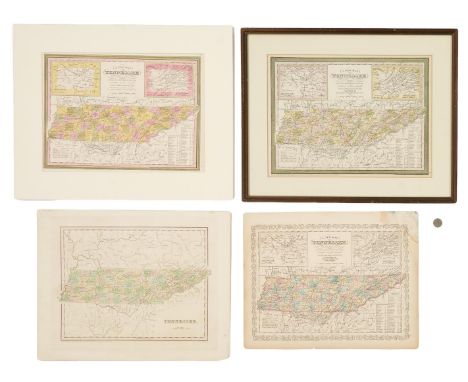
Lot 590
Four (4) 19th Century Tennessee Maps, incl. Thomas G. Bradford, 1838. 1st item: "Tennessee" Map by Thomas G. Bradford, engraved by George W. Boynton, 1838. From "A Comprehensive Atlas, Geographical, Historical & Commercial" by Thomas G. Bradford. Copper plate engraving with hand-coloring of Kentucky and Tennessee depicting towns and roads, county lines, names of counties, rivers, and mountains. Title and scale of miles, lower left. "Longitude West from Washington", centered below map. Map surrounded by scale notations and triple line border. Image - 11 1/4" H x 15" W. Sheet - 14 3/4" H x 18 7/8" W. 2nd item: "A New Map of Tennessee" by Samuel A. Mitchell, engraved by H. N. Burroughs, published by Samuel A. Mitchell, Philadelphia, 1846. From "A New Universal Atlas" by Samuel A. Mitchell. Lithographic engraving with hand coloring of Tennessee depicting towns and roads, county lines, names of counties, rivers, and mountains. Includes inset maps of the "Environs of Nashville", top left, and the "Environs of Knoxville", top right. Title and scale of miles, top center, explanation, lower left, distance tables, lower right. "Longitude West from Washington", centered above map. Map surrounded by scale notations and "Cary and Hart" border. Mounted to mat. Image - 11" H x 15" W. Sheet - 14" H x 17 1/4" W. Mat - 17" H x 21 1/8" W. 3rd item: "A New Map of Tennessee" by Samuel A. Mitchell, published by Thomas, Cowperthwait and Company, Philadelphia, 1855. From "A New Universal Atlas" by Samuel A. Mitchell. Lithographic engraving with hand coloring of Tennessee depicting towns and roads, county lines, names of counties, rivers, and mountains. Includes inset maps of the "Environs of Nashville", top left, and the "Environs of Knoxville", top right. Title and scale of miles, top center, explanation, lower left, distance tables, lower right. "Longitude West from Washington", centered above map. Map surrounded by scale notations and decorative border. Housed in wooden frame with mat. Image - 11 1/4" H x 15 1/4" W. Sight - 12" H x 16" W. Framed - 16 3/4" H x 20 7/8" W. 4th item: "A New Map of Tennessee" by Samuel A. Mitchell, published by Charles DeSilver, 1857. From "A New Universal Atlas" by Samuel A. Mitchell. Lithographic engraving with hand coloring of Tennessee depicting towns and roads, county lines, names of counties, rivers, and mountains. Includes inset maps of the "Environs of Nashville", top left, and the "Environs of Knoxville", top right. Title and scale of miles, top center, explanation, lower left, distance tables, lower right. "Longitude West from Washington", centered above map. Map surrounded by scale notations and fretwork border. Image - 11 1/2" H x 15 1/4" W. Sheet - 13 1/2" H x 17 1/4" W. All items American, early/mid 19th century. CONDITION: 1st item: Ghost tape mark, top right of sheet. Toning around edges of sheet. 1 1/4" tear, lower right corner. Black scuffs, largest 3/4", surface of sheet. Toning, visible en verso. 2nd item: Toning around edges of sheet. 3/8" hole top right of sheet. Minute foxing spots visible en verso. 3rd item: Toning visible around inside edge of matte. 1/4" toning spot, top left of map. Not examined outside of frame. 4th item: 5" area of water damage, top right corner. Slight toning around edges of sheet. Minute foxing spots on surface of map. 1/4" tear lower center edge of map. Toning, foxing spots visible en verso.

Lot 609
Mexican-American War ALS. One page handwritten bifolium. From Matthew Calbraith Perry, Commodore of the United States Naval Forces, Flagship USS Mississippi off Veracruz, Gulf of Mexico, to Paped Mid Francis Gregory, dated March 24, 1847. Written during the Battle of Veracruz, Perry commands Francis to "...report yourself to Captain [Issac] Mayo for duty on board the U.S. Steamer Mi[s]si[s]sippi under his command. Very respectfully &c M.C. Perry...". Address panel possibly secretarial signed with traces of a red wax seal and later pencil inscriptions. Includes PSA/DNA Letter of Authentication, number AB07334, dated Tuesday, July 26, 2016. Letter - 10" H x 8" W. Mid 19th century. Note: The Battle of Veracruz was a 20-day siege of the key Mexican beachhead seaport of Veracruz, during the Mexican-American War. Lasting from March 9-29, 1847, it began with the first large-scale amphibious assault conducted by United States military forces, and ended with the surrender and occupation of the city. U.S. forces then marched inland to Mexico City. CONDITION: Overall very good condition with light toning and few minute foxing spots. Perry signature and writing in overall very good legible condition.
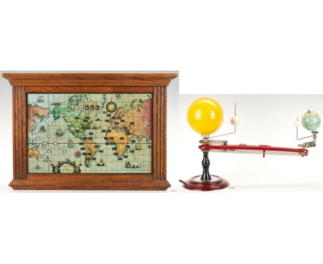
Lot 634
Trippensee Planetarium Co. Tellurian Model, Howard Miller Lighted World Map Electric Clock, 2 items total. 1st item: Trippensee Planetarium Company, Saginaw, Michigan, geared Tellurian model, manufactured by the George F. Cram Company. Comprised of painted wood or dense plastic globes representing the Earth, Moon, and Venus affixed to metal rod arms that revolve around a central yellow dense plastic sphere containing a lightbulb representing the sun on a maroon colored dense plastic arm with an inset compass, all mounted on a turned ebonized wooden pillar, set on a stepped round maroon colored dense plastic base, with a circular zodiac dial to the top, printed in black on silver. Iron weight on the underside of the base is stamped "1966." Maker's marks to maroon arm. Wired for electricity. 13 3/4" H x 20" W x 7 1/2" D. 2nd item: Howard Miller Clock Company lighted world time zone map electric clock, model 612-371, serial number 81830859. Comprised of a chromolithographic labeled world map printed to reverse of glass with open slots exposing different time zones of major cities around the world with slots for local time top center, all housed in an oak case. Cartouche with title, maker, scale of miles, copyright date "1959", and patent information, lower right. Informational paper label en verso. Wired for electricity with button switch, top of case. Glass map - 12 5/8" H x 19 1/2" W. Case - 18" H x 26 1/3" W. 5 1/2" D. Both items mid 20th century. CONDITION: 1st item: Overall good condition with surface wear, scuffs to globes. Gears, rotating parts on working condition. Electrical parts are functional. 2nd item: Overall good condition. Lighting mechanism was in working condition when tested. Few areas of loss, largest 3/4", to case.
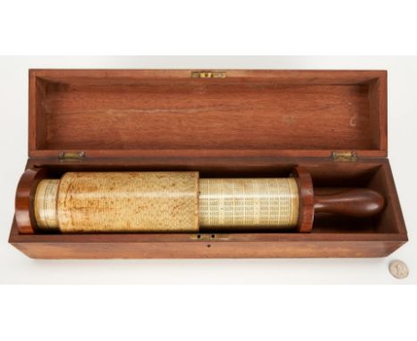
Lot 637
Keuffel & Esser (K&E) 4015 Fuller's Spiral Cylindrical Slide Rule, Model 1, serial number 1948. Composed of an exterior wooden movable cylinder with two brass rings lined with felt over a longer interior wooden cylinder, both covered with paper and marked with decimal, conversion, sine tables, and a logarithmic scale graduated into 7,250 parts, two brass indexes. Housed in a wooden box with ink stamp reading "Calculator". Maker's marks to exterior cylinder. Slide rule - 17" L x 3 1/2" dia. Box - 4" H x 18" W x 4 1/2" D. Early 20th century. (See: https://americanhistory.si.edu/collections/search/object/nmah_694149). Provenance: Private West Tennessee Collection. CONDITION: Toning, areas of surface abrasions to cylinders. Some wear, scratches, natural wood shrinkage to case.
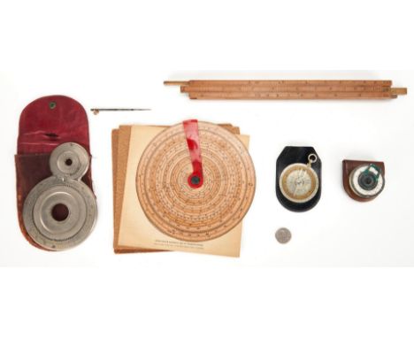
Lot 639
Five (5) early calculators or slide rulers, including one (1) G. Small Pocket Calculator, Roberts Everard type box rule, G. Charpentier Calculimetre, Sexton's Omnimetre Circular Slide Rule, and one (1) Webb Adder or figure-eight adder. 1st item: The "Small" Pocket Calculator, made by Gilbert Small, Boston, Massachusetts. Comprised of two rotating white laminated metal stacked discs, a metal and yellow glass cursor, and a central, pivoted hub. Includes original leather case. Calculator - 2" dia. Case - 2 1/2" H x 2 1/2" W x 1/2" D. 2nd item: Roberts Everard type 4-sided box rule, made by Edward D. Roberts, London, United Kingdom, each face for different tasks related to the production of alcohol and, more particularly, the imposition of duty on it. Comprised of four-sided boxwood, each side with one sliding scale. 12 1/8" L. 3rd item: G. Charpentier Calculimetre, No. 1796, manufactured by Tavernier - Gravet, Paris, France, sold by Eugene Dietzgen Company, Distributors, Chicago, New York. Comprised of a double-sided silver-colored disc surrounding a rotating brass ring, fork-shaped silver-colored indicator, all attached to a small suspension ring, the indicator extends around the all silver metal back. Maker's marks, front. Includes a black with case with gilt silver blindstamp lettering. Slide rule - 2 1/2" dia., with ring - 3 1/4" dia. Case - 4" H x 2 3/4" W x 1/8" D. 4th item: Sexton's Omnimetre Circular Slide Rule, Numeri Mudum Regunt, copyrighted by Thaddeau Norris in the United States, United Kingdom, and Canada. Comprised of two light brown cardstock discs with a transparent red celluloid arm and a black checkered finger nut at the center, held together by a brass colored fastener, visible en verso. Maker's marks and dated "1895" front and back. Includes one instruction sheet, printed by Craig, Finlet, and Company, Philadelphia, 1897. Slide rule - 7 1/4" dia. Instruction sheet - 7 3/8" square. 5th item: Webb Adder or figure-eight adder, unmarked but similar to those manufactured by Victor Adding Machine Company, Chicago, Illinois. Comprised of conjoined two nickeled brass wheels with a four digit read-out window in the center to the front. Checkered back. Includes a red leather case and stylus. Adder - 6 5/8" H x 4 1/2" W x 3/8" D. Case - 6 3/4" H x 4 3/4" W x 1/4" D. Stylus - 3 7/8" L. All items late 19th/early 20th century. Provenance: Private West Tennessee Collection. CONDITION: All items in overall good condition. 1st item: Oxidation to metal, some loss to paint on scales. 3rd item: Indicator to back is slightly bent. 4th item: Overall good condition with stains, toning. 5th item: Stylus is likely a replacement. Wear to case.
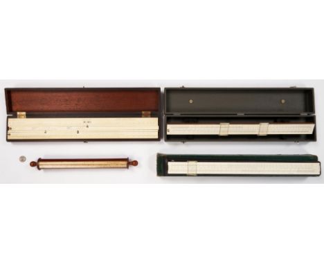
Lot 640
Four (4) Keuffel & Esser (K&E) slide rulers, including one (1) 4105 Webb's Stadia rule, one (1) Reymond Leather Calculator, and two (2) Merchant Desktop models. 1st item: 4105 Webb's Stadia rule, designed by Walter Loring Webb. Comprised of a wooden cylinder covered with paper scales, wooden handles at the ends of the cylinder, and a metal sleeve lined with felt. The sleeve, which is painted maroon, holds the cylinder. Maker's marks to paper scales. 15 3/4" L. 2nd item: Reymond Leather Calculator, copyrighted and patented by M.H. Reymond, designed for use in calculating the amount of leather in sq. feet needed for a run of shoes based on size, width, quantity, and type. Comprised of one-sided celluloid laminated mahogany with three sliding scales, two with brass thumb screws, four stationary scales, and three metal pointers, all mounted in a mahogany box with a hinged lid and brass hardware. Maker's marks, front. Calculator - 3 1/8" H x 22" W x 1/8" D. Box - 2 1/4" H x 22 1/2" W x 4" D. 3rd item: 68 1748 Merchant's Mannheim Desk Model, serial number 830026. Comprised of one-sided celluloid laminated mahogany with one slide scale and metal thumb screw, two stationary scales, two glass cursors with metal frames and white celluloid edges held together with metal screws, all mounted at an angle in a grey, Morocco case with a hinged lid and metal hardware. Maker's marks, front. Slide rule - 21 1/2" L. Case - 2 7/8" H x 22 1/2" W x 4 1/4" D. 4th item: N4096 M Merchants Rule, serial number 034880. Comprised of one-sided off white celluloid laminate mahogany, laminated paper label to back, plastic cursor with metal frame and white celluloid edges held together with metal screws. Maker's marks, front. Includes a black leather case and original green box. Slide rule - 21 1/2" L. Case - 23" H x 2 3/4" W x 1 1/4" D. Box - 23 1/2" H x 3 1/8" W x 1 3/4" D. All items early/mid 20th century. Provenance: Private West Tennessee Collection. CONDITION: All items in overall good condition. 1st item: Foxing spot/toning to paper scales. Craquelure, areas of loss to paint on sleeve. 2nd item: Calculator and box with wear. Box with inscriptions to interior of lid. 3rd item: Case with wear. Cracks, breaks to celluloid cursor edges. 4th item: Case and box with ink stamps from previous owner. Box with wear, areas of white archival tape repair.

Lot 895
After Shiro Kuramata (1934-1991) Vitra Design Museum 1:6 scale model version of his iconic "How High the Moon" chair, designed 1986. Nickel-plated steel and zinc mesh. Original brochure and slide-front wooden box included. 11 cm high x 15.5 cm wide x 13.8 cm deep (4 1/2" x 6" x 5 1/3"). Provenance: Private Nashville, TN collection, acquired late 1990s. CONDITION: Excellent condition.
Lot 102
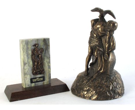
1916 Commemorative sculptures of Cuchullain. A small scale relief of 'The Dying Cúchulainn' by Oliver Sheppard. Manufactured under licence from The Commissioner of Public Works. Mounted on Connemara marble, raised on mahogany plinth; together with a cold cast bronze figure of the 'The Dying Cúchulainn' after Oliver Sheppard.The large original sculpture, which commemorates the 1916 Rising, is located in the G.P.O., Dublin.


Lot 277
1951 (September 15) Patrol map used by Royal Ulster Rifles in Korea, a 1:50,000 scale map of Majon-Ni, Korea, bearing a label, "This is the map I carried on patrol. page 89 RUR in Korea" loosely inserted in The Royal Ulster Rifles in Korea. Wm. Mullen & Son, Belfast, 1953, first edition, ex libris Major GL Potts; together with Corbally, Lieut.-Col. MJPM. The Royal Ulster Rifles, 1793-1957, Topical Advertising Service, Arbroath, 1959, 8vo,; also The Royal Ulster Rifles A Short History. John Aiken & Son, Belfast, 1937, etc.


Lot 259
A large and impressive 19th century carved mahogany centre table, of large proportions, of rectangular shape, with an scroll carved frieze, on square legs, with acanthus and scale decoration, on square feet, 210 x 88cm. Provenance: Dalby Hall, Lincolnshire. Purchased from Anthony Outred for £9,900 in 2000, with copy of receipt

Lot 2061
Mandola 10 strings labelled 'Made By Mr D. Freshwater, Scotland for Scayles Music Edinburgh, headstock has decal 'Freshwater', flat back instrument with adjustable bridge; together with Vox Clubman Bass Guitar, short scale with headstock decal 'JMI Dartford Kent' serial no.74993, with bridge guard 'Vox pa. ap. for' (2)Vox: Either body or paintwork appears to be cracked and machine head are non-original
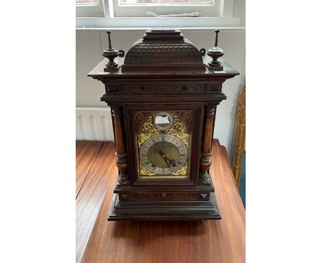
Lot 3
An Edwardian oak bracket clock, of architectural form the domed caddy top with fish scale decoration over a blind fret frieze, with two pierced doors to the side, turned pilasters to the front on plinth base, the arched dial with silvered chapter ring and subsidiary Slow/Fast dial to an 8 day two train movement with pendulum, 70cm high,


Lot 379
A circa 700BC Cretan terracotta amphora with fish scale incised decoration and central black painted band, length 40cm.Additional InformationOne of the lug handles has deteriorated and there is some marine encrustation to the narrow part. General surface wear throughout with a few nibbles around the rim.

Lot 87
Two Worcester plate circa 1780, painted with a Kakiemon style pattern, the other flowers on a blue scale ground, also a Staffordshire mug monogrammed and painted with a Cathedral, the plate measures 22cm diameterCONDITION REPORT: Wear to the first Worcester plate. Restoration to the blue scale plate. Damages to the Newhall teapot, the mug is free from faults.

Lot 66
Lothar Goetz Ball Game - Green, 2020 Watercolour on paper Signed verso 15 x 10cm (5¾ x 3¾ in.) Whilst Götz' practice ranges in scale from site-specific wall paintings and room-sized spatial installations to paintings and drawings, there is a clear coherence and dialogue across his body of work through its continual referencing and engagement with ideas about architecture and space and its characteristic use of abstract geometric forms, fields and lines of intense colour, juxtaposed with one another. His work is informed by real factors of circumstance, site, or the particular inhabitants or histories of a building, space or place, but mixes these factors with further imaginary or fantasy ones. Similarly many of his drawings represent the floor plans of idealized dwellings, sometimes for specific people or historical figures, sometimes for imagined ones. Together they form part of an ongoing series exploring spatial ideas for domestic spaces: apartments, houses, bungalows, villas.

Lot 67
Lothar Goetz Ball Game - Ochre, 2020 Watercolour on paper Signed verso 15 x 10cm (5¾ x 3¾ in.) Whilst Götz' practice ranges in scale from site-specific wall paintings and room-sized spatial installations to paintings and drawings, there is a clear coherence and dialogue across his body of work through its continual referencing and engagement with ideas about architecture and space and its characteristic use of abstract geometric forms, fields and lines of intense colour, juxtaposed with one another. His work is informed by real factors of circumstance, site, or the particular inhabitants or histories of a building, space or place, but mixes these factors with further imaginary or fantasy ones. Similarly many of his drawings represent the floor plans of idealized dwellings, sometimes for specific people or historical figures, sometimes for imagined ones. Together they form part of an ongoing series exploring spatial ideas for domestic spaces: apartments, houses, bungalows, villas.

Lot 68
Lothar Goetz House For Hope, 2020 Pencil and coloured pencil on paper Signed verso 15 x 10cm (5¾ x 3¾ in.) Whilst Götz' practice ranges in scale from site-specific wall paintings and room-sized spatial installations to paintings and drawings, there is a clear coherence and dialogue across his body of work through its continual referencing and engagement with ideas about architecture and space and its characteristic use of abstract geometric forms, fields and lines of intense colour, juxtaposed with one another. His work is informed by real factors of circumstance, site, or the particular inhabitants or histories of a building, space or place, but mixes these factors with further imaginary or fantasy ones. Similarly many of his drawings represent the floor plans of idealized dwellings, sometimes for specific people or historical figures, sometimes for imagined ones. Together they form part of an ongoing series exploring spatial ideas for domestic spaces: apartments, houses, bungalows, villas.

Lot 69
Lothar Goetz Garden for the Constructivist, 2020 Pencil and coloured pencil on paper Signed verso 15 x 10cm (5¾ x 3¾ in.) Whilst Götz' practice ranges in scale from site-specific wall paintings and room-sized spatial installations to paintings and drawings, there is a clear coherence and dialogue across his body of work through its continual referencing and engagement with ideas about architecture and space and its characteristic use of abstract geometric forms, fields and lines of intense colour, juxtaposed with one another. His work is informed by real factors of circumstance, site, or the particular inhabitants or histories of a building, space or place, but mixes these factors with further imaginary or fantasy ones. Similarly many of his drawings represent the floor plans of idealized dwellings, sometimes for specific people or historical figures, sometimes for imagined ones. Together they form part of an ongoing series exploring spatial ideas for domestic spaces: apartments, houses, bungalows, villas.

Lot 102
Fiona Grady Rainbow (AP1), 2020 Watercolour ink on paper Signed verso 15 x 10cm (5¾ x 3¾ in.) Fiona Grady creates site-responsive drawings on walls, windows and floors using sequences of dispersing geometric shapes. Her practice recognizes the relationship between architecture, installation art and decoration; often using traditional mediums, such as fresco painting and stained glass, in a contemporary context. She plays with light, surface and scale; each piece changes with the light of day emphasizing the passing of time and the ephemeral nature of the work. The artworks are imaginings of how light moves throughout a space, stretching and rotating with the throughout the day. However she does not seek to literally map light but instead create rhythms; the blocks of colour act as a vessel that pinpoints the viewers' presence within their setting and allows them to contemplate their surroundings. The artworks for Art on a Postcard auction were created during the coronavirus outbreak in her self-isolation kitchen studio. They are inspired by the rainbows created by children for the windows of their homes. The rainbows are a symbol of hope, a thank to our carers and frontline staff.

Lot 103
Fiona Grady Rainbow (AP2). 2020 Watercolour ink on paper Signed verso 15 x 10cm (5¾ x 3¾ in.) Fiona Grady creates site-responsive drawings on walls, windows and floors using sequences of dispersing geometric shapes. Her practice recognizes the relationship between architecture, installation art and decoration; often using traditional mediums, such as fresco painting and stained glass, in a contemporary context. She plays with light, surface and scale; each piece changes with the light of day emphasizing the passing of time and the ephemeral nature of the work. The artworks are imaginings of how light moves throughout a space, stretching and rotating with the throughout the day. However she does not seek to literally map light but instead create rhythms; the blocks of colour act as a vessel that pinpoints the viewers' presence within their setting and allows them to contemplate their surroundings. The artworks for Art on a Postcard auction were created during the coronavirus outbreak in her self-isolation kitchen studio. They are inspired by the rainbows created by children for the windows of their homes. The rainbows are a symbol of hope, a thank to our carers and frontline staff.

Lot 104
Fiona Grady Rainbow (AP3), 2020 Watercolour ink on paper Signed verso 15 x 10cm (5¾ x 3¾ in.) Fiona Grady creates site-responsive drawings on walls, windows and floors using sequences of dispersing geometric shapes. Her practice recognizes the relationship between architecture, installation art and decoration; often using traditional mediums, such as fresco painting and stained glass, in a contemporary context. She plays with light, surface and scale; each piece changes with the light of day emphasizing the passing of time and the ephemeral nature of the work. The artworks are imaginings of how light moves throughout a space, stretching and rotating with the throughout the day. However she does not seek to literally map light but instead create rhythms; the blocks of colour act as a vessel that pinpoints the viewers' presence within their setting and allows them to contemplate their surroundings. The artworks for Art on a Postcard auction were created during the coronavirus outbreak in her self-isolation kitchen studio. They are inspired by the rainbows created by children for the windows of their homes. The rainbows are a symbol of hope, a thank to our carers and frontline staff.

Lot 105
Fiona Grady Rainbow (AP4), 2020 Watercolour ink on paper Signed verso 15 x 10cm (5¾ x 3¾ in.) Fiona Grady creates site-responsive drawings on walls, windows and floors using sequences of dispersing geometric shapes. Her practice recognizes the relationship between architecture, installation art and decoration; often using traditional mediums, such as fresco painting and stained glass, in a contemporary context. She plays with light, surface and scale; each piece changes with the light of day emphasizing the passing of time and the ephemeral nature of the work. The artworks are imaginings of how light moves throughout a space, stretching and rotating with the throughout the day. However she does not seek to literally map light but instead create rhythms; the blocks of colour act as a vessel that pinpoints the viewers' presence within their setting and allows them to contemplate their surroundings. The artworks for Art on a Postcard auction were created during the coronavirus outbreak in her self-isolation kitchen studio. They are inspired by the rainbows created by children for the windows of their homes. The rainbows are a symbol of hope, a thank to our carers and frontline staff.
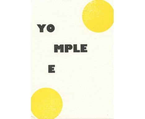
Lot 13
Stephen Kenny You Complete Me, 2020 Letterpress on paper Signed verso 15 x 10cm (5¾ x 3¾ in.) My paintings most often focus on the human figure paired with elements found in nature. These surreal, symbolic juxtapositions are intended to work on at least two levels. The first alludes to the fact that we are an integral part of the natural world and subject to its laws. This seems like an obvious statement until we step back and objectively assess our symbiotic relationship with each other and the Earth. Depending on your perspective, these relationships fall somewhere on the scale between harmonious and dysfunctional. The second turns the lens around to look inward upon the stewardship of our own emotional, intellectual and psychological landscapes. The same pictorial subject matter allows me to make references to our individual journeys of self-exploration and discovery. Again, depending on who is holding the compass, we are either lost or on the right path. At the very least, I desire to create images of beauty and mystery that allow the viewer to find their own personal significance in them.
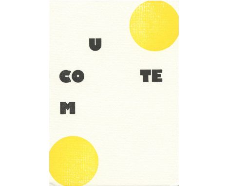
Lot 14
Stephen Kenny You Complete Me, 2020 Letterpress on paper Signed verso 15 x 10cm (5¾ x 3¾ in.) My paintings most often focus on the human figure paired with elements found in nature. These surreal, symbolic juxtapositions are intended to work on at least two levels. The first alludes to the fact that we are an integral part of the natural world and subject to its laws. This seems like an obvious statement until we step back and objectively assess our symbiotic relationship with each other and the Earth. Depending on your perspective, these relationships fall somewhere on the scale between harmonious and dysfunctional. The second turns the lens around to look inward upon the stewardship of our own emotional, intellectual and psychological landscapes. The same pictorial subject matter allows me to make references to our individual journeys of self-exploration and discovery. Again, depending on who is holding the compass, we are either lost or on the right path. At the very least, I desire to create images of beauty and mystery that allow the viewer to find their own personal significance in them.
-
186097 item(s)/page