We found 216136 price guide item(s) matching your search
There are 216136 lots that match your search criteria. Subscribe now to get instant access to the full price guide service.
Click here to subscribe- List
- Grid
-
216136 item(s)/page

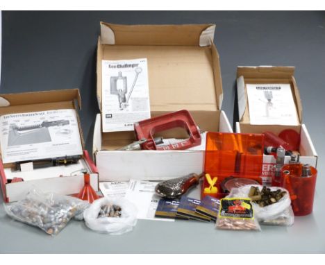
Lot 1121a
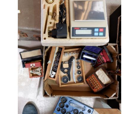
A collection of Lee .303 and .45-70 reloading equipment including Challenger Press Kit, Safety Powder Scale and Perfect Powder Measure, various reloading dies, empty brass cases, bullet tips, primers etc some in original boxes together with an embossed powder flask and various lead ball bullets


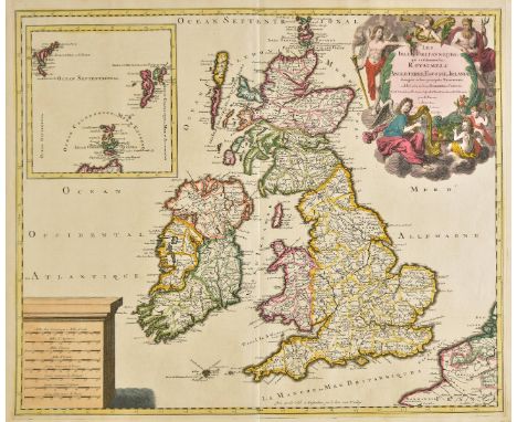
Lot 259
British Isles. Valk (Gerard), Les Isles Britanniques, qui contiennent les Royaumes d'Angleterre Ecosse, et Irlande..., Tire de G. Cambdene, Chr. Saxton, I. Speede, T. Pont, R. Gordon, et de I. B. Boazius, published Amsterdam, [1694], engraved map with contemporary hand colouring, inset map of the Shetland and Faroe Islands, large allegorical cartouche and mileage scale, 485 x 585 mm, together with De Wit (Frederick), Nova Totius Angliae, Scotiae et Hiberniae..., circa 1680, engraved map with contemporary outline colouring, 480 x 565 mm Both maps in good condition. (2)
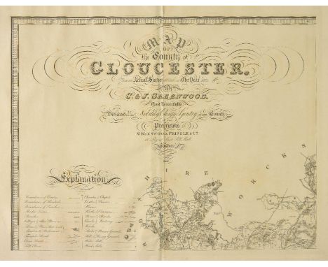
Lot 291
Gloucestershire. Greenwood (C. & J.), Map of the County of Gloucester, from an actual survey made in the year 1823, published November 22nd. 1824, large scale uncoloured engraved map on six sheets, calligraphic title, compass rose, table of explanation and a vignette of the South west view of Gloucester cathedral, slight offsetting, one sheet split along central fold, bound with later endpapers, modern half calf with contrasting morocco gilt label to spine, some scuffing to boards and extremities, slim folio (1)
![Merionethshire & Montgomeryshire. Speed (John), Merionethshire described, published George Humble, [1627], hand coloured](https://cdn.globalauctionplatform.com/bdcc24b5-51e4-450c-9a38-a98300b3d03e/5f5a5cd3-b1f7-4975-9045-a985012d1e31/468x382.jpg)
Lot 314
Merionethshire & Montgomeryshire. Speed (John), Merionethshire described, published George Humble, [1627], hand coloured engraved map, inset town plan of Harlech, large strapwork cartouche, mileage scale and compass rose, 385 x 515 mm, English text on verso, mounted, together with Blaeu (Johannes), Montgomeria comitatus et comitatus Mervinia, Amsterdam, circa 1645, engraved map with bright contemporary hand colouring, 385 x 500 mm, French text on verso, mounted (2)
Lot 318
*Norfolk. Saxton (Christopher & Kip William), Norfolciae comitatus quem oli Iceni insederunt..., [1637], hand coloured engraved map, slight staining, 275 x 385 mm, mounted, framed and glazed, together with Ogilby (John), The road from Kings-Lyn to Norwich continued to Yarmouth in Norfolk..., [1675 or later], hand coloured engraved strip road map, 355 x 455 mm, mounted, framed and glazed, with Morden (Robert), Norfolk [1695 or later], hand coloured engraved map, old folds, some marginal tears affecting image, 370 x 580 mm, mounted, framed and glazed, plus Cary (John), A new map of Norfolk, divided into hundreds exhibiting its roads, rivers, parks &c., 1807, engraved map with contemporary outline colouring, 490 x 550 mm, mounted, framed and glazed, with three other small scale maps of Norfolk and Norwich by Dawson, Cary and Wallis, all hand coloured and all framed and glazed, various sizes and condition, plus one other (7)
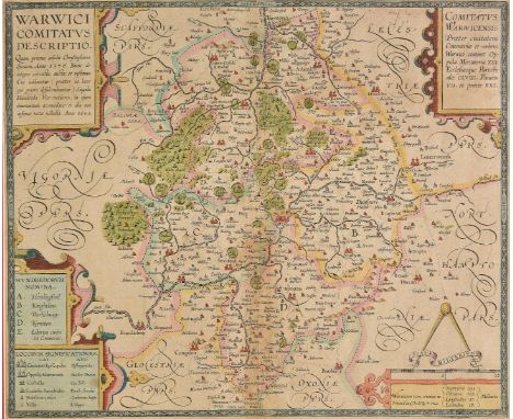
Lot 357
Worcestershire & Warwickshire. Blaeu (Johannes), Wigorniensis comitatus et comitatus Warwicensis nec non Coventrae Libertas. Worcester, Warwik Shire and the Liberty of Coventre, Amsterdam [1658], engraved map with contemporary hand colouring, 410 x 505 mm, Spanish text on verso, mounted, together with Bowen (Emanuel), An accurate map of Worcester divided into hundreds and drawn from the best authorities..., published R. Sayer & Carington Bowles [1779], engraved map with contemporary outline colouring, 535 x 710 mm, together with Bowen (Emanuel), An Accurate map of Worcester divided into its hundreds and drawn from the best authorities..., R. Sayer, C & J Bowles, 1756, engraved map with contemporary outline colouring and some later enhancement, 530 x 705 mm, together with Saxton (Christopher & Hole W.), Wigorniensis comitatus Sabrinae fluminis..., [1637], hand coloured engraved map, large strapwork cartouche, mileage scale and compass rose, 285 x 320 mm, with Van den Keere (Pieter), Worcestershir. circa 1627, hand coloured engraved miniature map, horizontal margins extended, 850 x 125 mm, English text on verso, plus Tunnicliff (William), A new map of Worcestershire..., 1788, engraved map with outline colouring, vertical margins extended, old folds, 470 x 460 mm, with another thirteen maps of Worcestershire, including examples by Conder, Moule, Cary, Lodge, Whittaker, Seller/Grose, Kitchin, Owen & Bowen and Harrison, occasional duplicates, various sizes and condition (19)
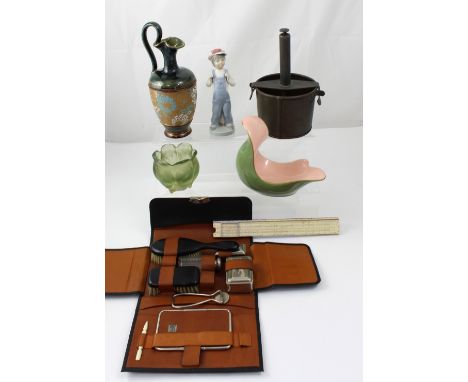
Lot 245
A collectors' lot to include a vintage copper tongue press, a fitted gentlemen's vanity case, a scale slide rule by Faber Castell, a Carlton ware hand-painted spoon rest, a Royal Doulton Secessionist jug, height 21cm, a moulded glass tealight holder and a Lladró figure of a young boy in butcher's cap (7).
-
216136 item(s)/page