We found 216136 price guide item(s) matching your search
There are 216136 lots that match your search criteria. Subscribe now to get instant access to the full price guide service.
Click here to subscribe- List
- Grid
-
216136 item(s)/page

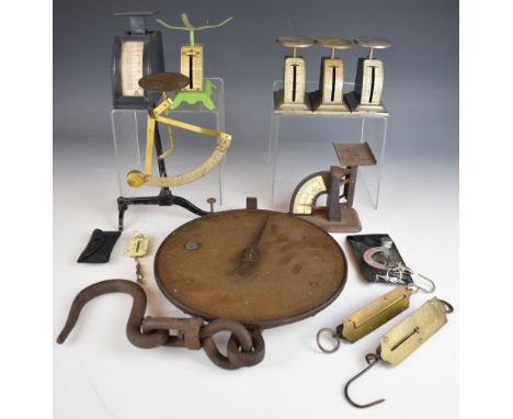

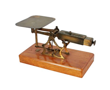
Lot 1192
Victorian four tier GPO ladder postage scale or balance with flip over weights for different scales on each tier covering both metric and imperial, by Degrave, Short & Fanner, London, stamped multiple times with broad arrow and GPO, together with a stack of five weights and a 2oz GPO square weight, being sold by the now closed Bath Postal History Museum
![[Rhodes] Map of the River Severn Extending from Near The Lower Parting in The County of Gloucester to Gladder or Whitehouse B](https://cdn.globalauctionplatform.com/b70270c9-c3ec-45df-bd1c-b1d4013580c7/a97f9711-8e71-4c70-a5d4-b20200ea402e/468x382.jpg)
Lot 420
[Rhodes] Map of the River Severn Extending from Near The Lower Parting in The County of Gloucester to Gladder or Whitehouse Brook within the Parish of Areley Kings and County of Worcester showing the Proposed Cuts or Canals and the sites of the proposed Locks and Weirs for improving the Navigation of the same, through Gloucester, Tewkesbury and Worcester to Stourport, Scale 10cm to 1 mile, and includes enlarged plans, heightened in colour & engraved by J. Gardner of London [Map of a survey made under the direction of Thomas Rhodes which was originally issued in 1837 for the Severn Navigation Company], mounted on linen and extending to 360cm
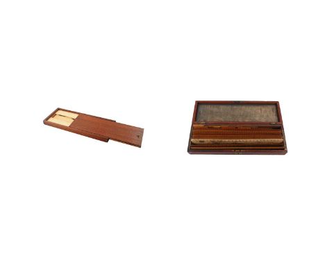
Lot 200
A 19th Century mahogany box of engineering rules and set square by Elliot Brothers, stamped 'Elliot Bros, 449 Strand, London', 33.3cms long; and a late 19th Century mahogany box of engine divided rulers by David Robertson & Co Ltd Glasgow, the mahogany box is brass pinned and has an inset plaque with 'R.B. McKeen' engraved, contents includes ten 12inch rulers, and nine small scale rulers, the rulers are all stamped with the maker's name and the owner's initials, box 4.2 x 33.8 x 10.8cms. (2)PROVENANCE: The Graham Smith Retirement Auction - 50 years in the Antiques Trade.
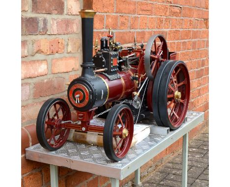
Lot 1
CATALOGUE AMENDMENT: Burrell 2" scale steam traction engine, length 93cm, width 39cm, plaque states 'Chas Burrell & Sons limited, manufacturers, Thetford, England, no. 1856', finished in maroon with gold trim, operational steering mechanism, on custom built rolling stand. No boiler certificate. NOTE: this was originally stated as being 3" scale, this is incorrect and is in fact 2" scale.

Lot 4
A 5-inch gauge narrow gauge live steam locomotive and tender, scale model of South African Railways 4-4-0 class NG6 steam locomotive no. NG 104, Fowler tender, green with red plates, locomotive length 105cm, width 35cm, tender length 64cm, boiler certification for 1990 and 1995, with 5-inch gauge narrow gauge oil tanker, sections of display track, and display stand
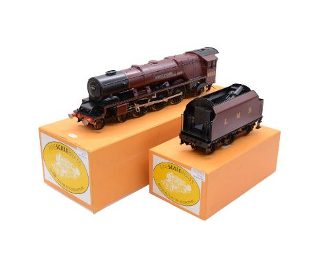
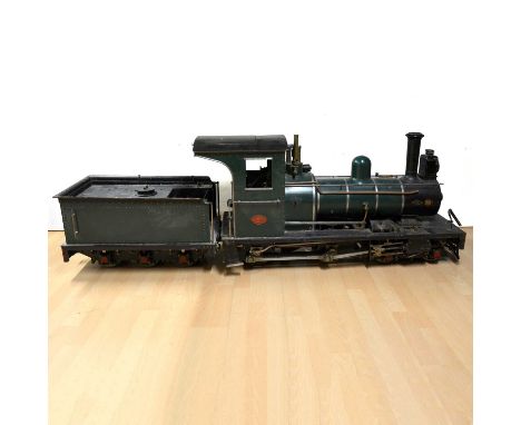
Lot 8
Fine Scale Brass gauge 1 model railway steam locomotive and tender, LMS 4-6-2 Coronation class 'Duchess of Sutherland' no. 6233, 2-rail, boxed with tender boxed seperatelyCondition report:The model is in good condition, though the stairs to the cab have detached, they are still with the model but will need reattaching.The paintwork is in good condition, with no notable scratches and marks besides some light scratching to the underside of the locomotive, likely where an attempted reattaching of the aformentioned stairs has been made.Additional images have been added, along with an image of the detached part.
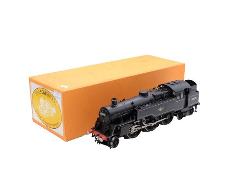
Lot 7
Fine Scale Brass gauge 1 model railway locomotive, BR 2-6-4T class 4 tank locomotive no. 80070, in BR black, 2-rail, boxedCondition report:The model has some damage to the smoke box door lock, the detached part is still with the model. The paintwork shows no damage besides the exposed metalwork where the smoke box door lock has detached. Additional photos have been added including the smoke box door lock damage.
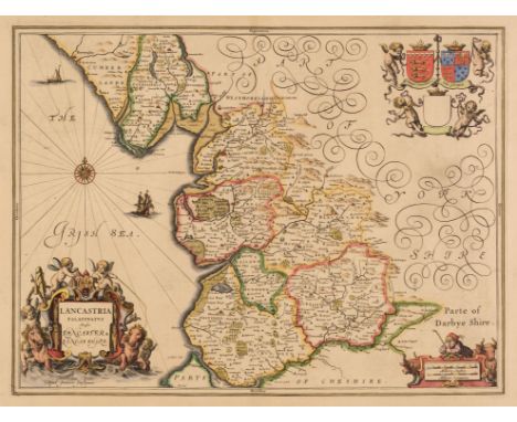
Lot 146
Lancashire. Jansson (Jan), Lancastria Palatinatus Anglis Lancaster & Lancashire, Amsterdam: circa 1650, hand-coloured engraved map, decorative cartouche and mileage scale, compass rose and numerous rhumb lines, 380 x 505 mm, Latin text on verso, together with Cambridge. Blaeu (Johannes), Cantabrigiensis Comitatus Cambridge Shire, Amsterdam: circa 1660, engraved map with contemporary hand-colouring, slight thinning to paper and margins, strengthened on verso, 420 x 425 mm, French text on versoQTY: (2)
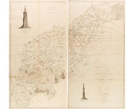
Lot 164
Northamptonshire. Faden (Robert), The County of Northampton as Surveyed and Planned by the late Mr Thomas Eyre of Kettering, Revised by the late Mr Thomas Jefferys Geographer to the King and engraved by Willam Faden..., 3rd edition, London: William Faden, 1791, large scale uncoloured engraved map on 4 sheets joined in pairs, engraved views of Geddington Cross and Queens Cross, old folds strengthened to verso, printers creases, small hole with loss to lower left sheet, overall size if conjoined 2480 x 1320 mm QTY: (2)NOTE:The first large-scale map of Northamptonshire.
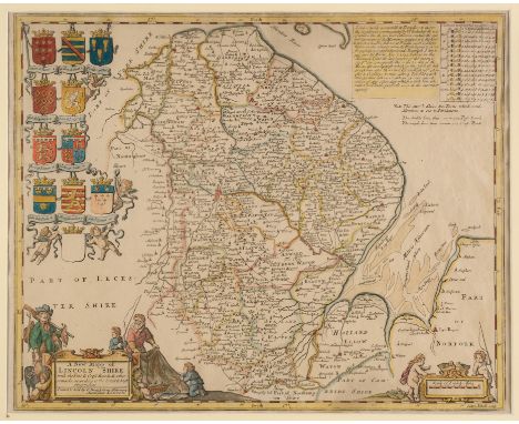
Lot 149
* Lincolnshire. Sutton Nicholls (engraver), A New Mapp of Lincoln Shire with the Post & Cross Roads & other remarks, according to the latest and best observations, printed and sold by C. Dicey & 1770, hand-coloured engraved map decorative cartouche, mileage scale, heraldic shields and a table of moons and tides, old folds, 390 x 485 mm, mounted, framed and glazedQTY: (1)NOTE:Uncommon.
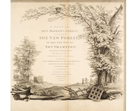
Lot 157
New Forest. Faden (William). A Plan of His Majesty's Forest, called The New Forest in the county of Southampton, laid down from surveys taken by Thos. Richardson, Wm. King and Abm. and Wm. Driver, by order of the Commissioners of the Land Revenue appointed by an Act of Parliament, passed in the 26th year of King George, 1st edition, 1789, a large-scale map on 10 engraved sheets (including the index map), 9 with bright contemporary wash colouring and 1 incorporating a large uncoloured decorative cartouche, a list of the Officers and Wardens of the New Forest, a list of the Bailiwicks and Walks in the forest, compass rose and table of explanation, small margins, small near-contemporary ink annotations to the verso of each sheet, each sheet approximately 575 x 580 mm (overall sheet size 645 x 820 mm), later card portfolio with some wear, slim upright folioQTY: (1)NOTE:A rare map of the New Forest whose accuracy ensured that it was in continual use in several editions up until the late 19th century. We can find only three other copies of this, the first edition, appearing in an auction in the last twenty years, with two being in these rooms in January 2018 & June 2024.
![West Africa & Guinea. Mercator (Gerard & Hondius Jodocus), Guineae nova Descriptio, [1606-36], engraved map with cont](https://cdn.globalauctionplatform.com/77603c7d-ab27-4102-b3a0-b17f00af972b/b0990ab9-14dd-4f5b-b497-b1f701035df8/468x382.jpg)
Lot 184
West Africa & Guinea. Mercator (Gerard & Hondius Jodocus), Guineae nova Descriptio, [1606-36], engraved map with contemporary hand-colouring, inset map of St. Thomas Island, large strapwork cartouche and mileage scale, large margins, some water staining to the lower margin but not affecting the printed image, 345 x 495 mm, Latin text on verso, together with another uncoloured example but with a closed tear affecting the printed image, French text on verso, with Jansson (Jan). Guinea, Amsterdam: circa 1650, engraved map with contemporary outline colouring, vertical margins heavily water stained, with mould and slight fraying, 385 x 520 mm, Dutch text on verso, plus Zatta (Antonio). La Guinea Occidentale che contiene Le Isole di Capo Verde Il Senegal la Costa Propriamente detta della Guinea [and] La Guinea orientale che contiene Li Regni di Loango, Congo Angola E Benguela, Venice: 1784, two engraved maps with contemporary outline colouring, 'La Guinea Orientale' with slight staining, each approximately 420 x 325 mm, and another eight maps of Guinea, including examples by or after Bonne, Bellin and Arrowsmith, occasional duplicates, various sizes, good conditionQTY: (13)

Lot 145
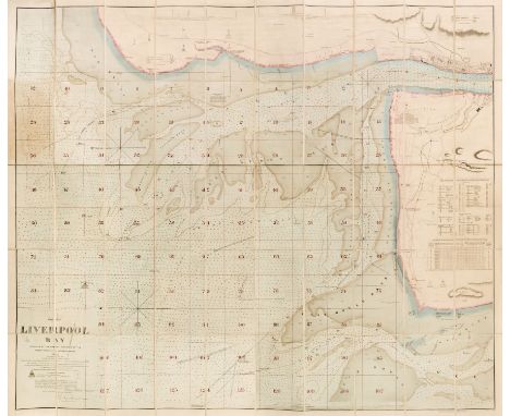
Lancashire. Hennet (G.). A Map of the County Palatine of Lancaster Divided into Hundreds and Parishes from an accurate survey made in the years 1828 and 1829, Henry Teesdale and Co. May 1st. 1830, large-scale engraved map with bright contemporary wash colouring, sectionalised and laid on linen, calligraphic cartouche, compass rose, table of explanation, uncoloured vignette of the New Custom House Liverpool, slight offsetting, edged in green silk, marbled endpapers, 1615 x 1130 mm, contained in a contemporary marbled calf book box with contrasting red morocco gilt label to the spine, some wear to extremities, together with Liverpool. Walker (J & C), Liverpool Bay surveyed by the Marine Surveyor of the Mersey Docks and Harbour Board, 1866. Corrected to 1880. Scale of two nautic miles, large engraved sea chart with contemporary outline colouring, sectionalised and laid on linen, manuscript reticulation into a grid of 127 squares, 1225 x 1415 mm, marbled endpapers, contained in a morocco gilt slipcase, worn and rubbed at the extremities, with Ordnance Survey (publishers). Liverpool and its Environs, 1850, uncoloured engraved map on a scale of six inches to the mile, sectionalised and laid on linen, slight dust soiling and staining, cloth endpapers, 980 x 1270 mm, contained in a near-contemporary slipcase but with a 'Bowles's England by Paterson' on the spine, slipcase split and rubbed, plus George Philip & Son (publishers). Philip's Trigonometrical Plan of the Town & Port of Liverpool from Actual Survey, 1858, large lithographic map with bright contemporary wash colouring, on two sheets, sectionalised and laid on linen, calligraphic title, compass rose and table of the wards, occasional small holes where old folds cross, slight dust soiling and offsetting, left-hand sheet 1100 x 1380 mm, right-hand sheet 1300 x 1380 mm, edged in green silk, marbled endpapers, bound in contemporary morocco gilt boards, heavily worn and rubbed, bound size 250 x 290 mmQTY: (4)
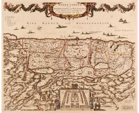
Lot 133
Holy Land. De Wit (Frederick), Terra Sancta sive Promissionis olim Palestina recens delineata..., Amsterdam, circa 1680, engraved map with contemporary outline colouring, inset plan of the encampment of the Israelites flanked by the figures of Moses and Aaron, orientated to the west, slight staining and offsetting, central fold partially split and repaired on verso, 455 x 550 mm, together with Moxon (Joseph). Canaan or the Land of Promise, Possessed by the Children of Israel and Travelled through by our Saviour Jesus Christ and his Apostles. Translated by Joseph Moxon, Amsterdam: Nichlaus Visscher, circa 1680, hand-coloured engraved map, ornamental cartouche and mileage scale, inset bible scenes, central fold strengthened on verso, repaired closed tear to the upper right corner, 320 x 465 mmQTY: (2)
Lot 150
Liverpool. Walker (J & C, publisher), Liverpool Bay surveyed by the Marine Surveyor of the Mersey Docks and Harbour Board, 1874 corrected to October 1875, scale of two nautic miles, large folding engraved sea chart with contemporary wash colouring, sectionalised and laid on linen, neat manuscript reticulation in red ink, some areas of light toning, 1250 x 1490 mm, marbled endpapers, bound into half calf gilt boards, together with Philip (George & Son). Philips' Plan of the Town & Port of Liverpool with Birkenhead and the adjoining Cheshire Coast, circa 1860, folding engraved map with contemporary wash colouring, sectionalised and laid on linen, 625 x 715 mm bound into red gilt buckram boards, with Philip (George & Son). Philips' Plan of Liverpool and the Adjoining Cheshire Coast compiled by actual surveys, uncoloured folding engraved map, sectionalised and laid on linen, bound into green buckram boards with publishers' printed guide to the city, 800 x 1200 mm, plus Eyres (Charles, publisher). A Plan of the Town & Township of Liverpool from an actual survey taken in the year 1785 [but mid 19th-century], uncoloured lithographic map, sectionalised and laid on linen, originally engraved by Thomas Conder, decorative cartouche incorporating panorama of Liverpool, slight staining, 535 x 875 mm, marbled endpaper, publisher's blind-stamped gilt cloth boards, remains of silk tie, upper board detached, rubbed and worn, with another late 19th-century plan of Liverpool similar QTY: (5)

Lot 177
* Somerset. Saxton (Christopher & Kip William), Somersettensis comitatus vulgo Somersett Shyre, qui olim pars suit Belgarum [1607], hand-coloured engraved map, large strapwork cartouche and mileage scale, slight text show through, 275 x 380 mm, mounted, framed and glazed, Latin text on versoQTY: (1)
Lot 122
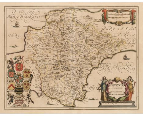
Devon. Jansson (Jan), Devoniae Descriptio. The Description of Devon-Shire, Amsterdam, circa 1646, engraved map with contemporary outline colouring, large decorative cartouche and mileage scale, slight spotting, 385 x 495 mm, French text on verso, together with Blaeu (Johannes). Devonia vulgo Devon-Shire, circa 1645, engraved map with contemporary outline colouring, some staining and spotting, 390 x 500 mm, Latin text on versoQTY: (2)
Lot 87
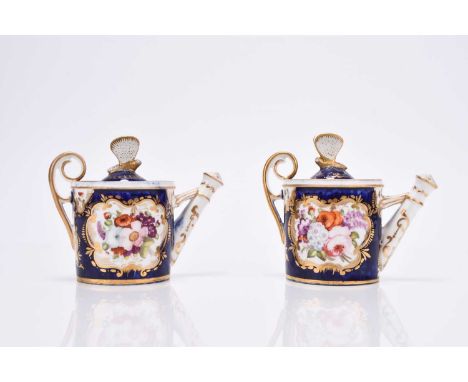
A pair of Coalport miniature rosewater sprinklers in the form of watering cans, circa 1810-20, of drum form with raised upper handle and butterfly finial to the covers, scale blue ground reserved with nicely painted panels of flowers with gilt borders, unmarked, 9.5cm high (2)Condition:Restoration to both butterfly finials, otherwise good. Small firing crack around the upper terminus of one handle. Gilt mostly intact but some minor wear to one handle and around the upper rims.
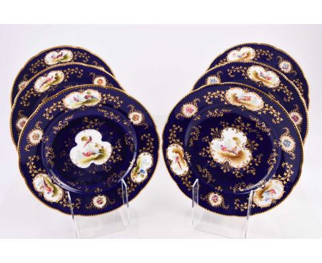
Lot 95
A set of six Coalport dessert plates, early 20th century, painted with fancy birds by Frederick Howard, in gilt lined cartouches on a dark scale blue ground, artist signed, printed factory mark and T. Goode retailer's marks and pattern '6042' in puce, 23cm diameter (6)Condition:Good condition with no damages or repairs. One plate has a noticeable long scratch to the left of one centre panel, but still rings true when tapped. Two other plates have some wear to the central gilding.

Lot 76
Tudor: A gentleman's stainless steel chronograph bracelet watch Model: Oysterdate 'Monte Carlo' Reference: 7169/0 Date: 1974 Movement: 17-jewel Valjoux Cal.234 manual wind Dial: Grey, black and luminous block hour markers, white outer 1/5th second divisions on black ground with outer orange Arabic five minute markers, subsidiary dials at 3 and 9 for constant seconds and 45 minute recording, magnified date aperture at 6, black baton hands with luminous inserts, orange centre chronograph hand Case: Brushed and polished tonneau form, screw down back, shouldered screw down crown flanked by twin screw down pushers, rotating bezel with black 12 hour insert for second time zone Strap/Bracelet: Rolex 78360 Oyster link bracelet Buckle/Clasp: Rolex logo fold over Size: 39mm Accompaniments: Tudor box Footnote:In 1971, Tudor introduced its new 7100 series chronographs which became known to collectors as the 'Monte Carlo' in light of the coloured dial resembling a roulette wheel. In updating their range of chronographs, Tudor replaced the Valjoux Calibre 7734 movement with the manual wind Calibre 234, which offered greater accuracy and a more sophisticated chronograph mechanism with a clutch column wheel. In addition, the dials were offered in two colourways, grey and blue, with matching bezels. Reference 7149/0 was fitted with a fixed bezel with coloured tachymeter insert, 7159/0 had a satin steel bezel with etched tachymeter scale, and 7169/0, as in the present lot, offered a rotating bezel with 12 hour markers to record a second time zone. The watches were typically supplied with an Oyster link steel bracelet which evolved into the solid link type, reference 78360, as in the present lot.According to the vendor, the watch was purchased by her late husband who wore it sparingly on special occasions only and hence it is found in very good overall condition. Condition:Case and back: A few fine scratches only.Crystal: Good.Dial: Good.Hands: Good.Strap: Good.Movement: Winds, sets and runs. Chronograph functions.Accompaniments: Box shows negligible signs of age.Unless otherwise stated, all watches are likely to have been serviced and/or repaired in their lifetime and may have had parts replaced. While a watch may be described as 'working' at the time of the report, they are not guaranteed for timekeeping, mechanical durability or waterproofing (where applicable) - it is advised that all watches are inspected and serviced by a qualified jeweller or horologist before full use. The cost of servicing can be significant and so we strongly advise obtaining a quote before placing your bid.


Lot 376
Corgi and Exclusive First Editions diecast buses, including Corgi Buses in Britain 1:50 scale AEC Routemaster Delaine CC25905, Corgi The Connoisseur Collection AEC Routemaster Metro Line CC25901, Exclusive First Editions AEC RT3 bus London Country, EFE The Routemaster Series RML Routemaster The Routemaster Series Ariva Last Day in Service 31902, etc. (1 tray)


-
216136 item(s)/page