We found 186097 price guide item(s) matching your search
There are 186097 lots that match your search criteria. Subscribe now to get instant access to the full price guide service.
Click here to subscribe- List
- Grid
-
186097 item(s)/page


Lot 40
FRENCH ADRIEN DUBOIS COMBINATION BOTANY GADGET CANE CIRCA 1880 - 1920 bamboo cane with finger pull in the ash handle that allows the shears to the end to snip, the handle also with a small concealed pollination brush and gilt-stamped 'Fleur' and 'Fruit' verso with a brass cap to the end, the cane and handle with ink inscription 'T. Methven, 15 Princes St, Edinburgh'Dimensions:119cm longProvenance:Provenance: Thomas Methven was a noted Scottish botanist and businessman that set up the firm of Thomas Methven & Sons based at 15 Princes Street, Edinburgh. They were large-scale purveyors of seeds, nursery plants and also a florist. The firm once had premises on Macdonald Road and several nurseries based around the city including at 9 Croall Place, Leith Walk and Warriston, Inverleith and Bangholm. Following the death of their father, the business was run by his sons Henry & John Methven. John was closely connected with the two important Scottish horticultural societies, the Royal Caledonian and the Scottish Association. He also had links with the Royal Scottish Arboricultural Society.Note: Note: For an identical example see the collection of the Isabella Stewart Gardner Museum

Lot 27
Large Scale County Maps. A collection of 38 sheets from various maps, 18th & 19th century, large-scale engraved map sheets, many with contemporary hand-colouring, including examples from Benjamin Donne's map of Devon, Chapman & André's map of Essex, Andrews and Dury's Sixty-five miles round London, John Rocque's map of Berkshire, Hodskinson's map of Suffolk, Taylor's map of Gloucestershire and Armstrong's map of Lincolnshire, occasional duplicates, some sheets torn and frayed with occasional loss, a few sheets town along the central fold, various sizes and conditionQTY: (38)
Lot 32
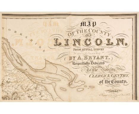
Lincolnshire. Bryant (Andrew), Map of the County of Lincoln from Actual Survey within the years 1825, 26 & 27..., Respectfully Dedicated to the Nobility, Clergy & Gentry of the County, April 19th 1828, large scale engraved map on eight double-page sheets, calligraphic title, compass rose, tables of explanation and divisions, engraved vignette of Lincoln Cathedral, some offsetting throughout, occasional small repaired marginal tears, each sheet approximately 530 x 815 mm, contemporary half sheep, lacking spine, boards detached, heavily worn and frayed, slim folio, binding size 585 x 465 mmQTY: (1)NOTE:The first and only edition of this large-scale map. Bryant produced 13 county maps very much in the style of the Greenwood brothers.
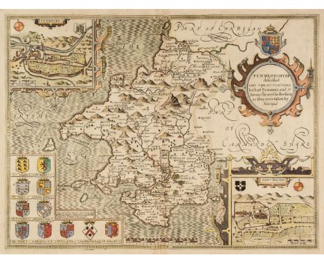
Lot 45
* Pembrokeshire. Speed (John), Penbrokshyre described and the Sittuations both of Penbroke and St. Davids shewed in due form as they were taken..., Thomas Bassett & Richard Chiswell [1676], hand-coloured engraved map, inset town plans of Pembroke and Saint Davids, large strapwork cartouche, 385 x 510 mm, mounted, framed and double-glazed, English text on verso, together with Blome (Richard). A Generall Mapp of South Wales..., circa 1673, hand-coloured engraved map, old folds, some spotting, 350 x 460 mm, mounted, framed and glazed, with Saxton (Christopher & Hole G.). Caernarvo. Comitatus pars olim Orovicum [1627], hand-coloured engraved map, large strapwork cartouche, compass rose and mileage scale, 255 x 310 mm, mounted, framed and glazedQTY: (3)
Lot 50
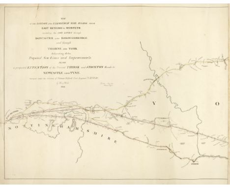
Road Maps. Telford (Thomas). Three Monumental road maps: Map of the London and Edinburgh Mail Roads from London to East Retford, including the two Lines to Alconbury Hill through Hatfield and Ware..., 1827, Map of the London and Edinburgh Mail Raods from East Retford to Morpeth including the two Lines through Doncaster and Boroughbridge and through Thorne and York..., 1826 [and] London and Morpeth Mail Road Index Map, Surveyed by Thos. Telford, printed at the Lithographic Establishment Quarter Master Gen.ls Office, Horse Guards, 1827, lithographic maps with contemporary outline colouring, the first described item on five sheets, torn with slight loss to the lower left corner of the first sheet, old glue marks to the margins where previously conjoined, each sheet approximately 475 x 670 mm, the second item on six sheets, old glue marks where previously conjoined, closed marginal tear on the left-hand vertical margin, each sheet approximately 470 x 605 mm, the third item on seven sheets, some dust soiling, occasional marginal closed tear with slight loss, each sheet approximately 660 x 500 mmQTY: (18)NOTE:Scarce monumental road maps on a scale of 2 miles to the inch.
Lot 33
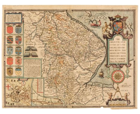
Lincolnshire. Speed (John), The Countie and Citie of Lyncolne Described with the Armes of them that have bene Earles thereof since the Conquest, 1st edition [1611], hand-coloured engraved map, inset city plan of Lincoln, large strapwork cartouche and compass rose, small chip in the lower border with slight loss to the strapwork margin, 385 x 515 mm, English text on verso, together with Blaeu (Johannes). Comitatus Brechiniae Breknoke, Amsterdam, circa 1648, engraved map with contemporary hand-colouring, decorative cartouche and mileage scale, mount stained and a little toned, 380 x 505 mm, German text on versoQTY: (2)
Lot 1
Bartholomew (John). The Imperial Map of England & Wales According to the Ordnance Survey..., A. Fullarton & Co. London & Edinburgh, circa 1870, index toned, 18 colour lithographic double-page map sheets, slight spotting throughout, lacking front endpaper, rear endpaper torn with some loss, contemporary cloth gilt, upper board detached, heavily worn and frayed, folio, together with Ordnance Survey (publishers). Ordnance Survey Atlas of England & Wales, and Ordnance Survey Atlas of Scotland, 2 volumes, 1922 - 24, double-page colour lithographic maps, on a scale of a Quarter Inch to the Mile, each map backed with linen, slight spotting throughout, publisher's cloth gilt, The Atlas of England & Wales, toned, frayed and with spine partially detached, oblong folio, with another copy of the Atlas of England and Wales, with Bowen (Emanuel). An Accurate Map of the Counties of Leicester and Rutland Divided into their Respective Hundreds..., circa 1765, engraved map with contemporary outline colouring, sectionalised and laid on linen, thread margins, contained in a contemporary marbled card slipcase with printed label to the upper cover, worn and frayed, plus another nine late 19th & early 20th-century folding county maps, touring maps and town plans, including examples by or after Stanford, Bartholomew, Bacon and Ordnance Survey, various sizes and conditionQTY: (14)NOTE:Sold as a collection of maps, not subject to return.
Lot 30
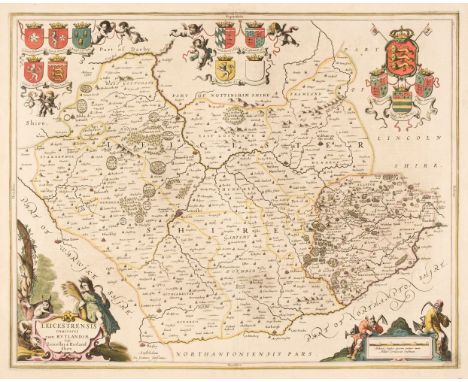
Leicestershire & Rutland. Jansson (Jan), Leicestrensis Comitatus cum Rutlandiae vulgo Leicester & Rutlandshire, Amsterdam, circa 1650, engraved map with contemporary outline colouring, decorative cartouche and mileage scale, slight staining, 440 x 550 mm, French text on verso, together with Blaeu (Johannes). Leicestrensis Comitatus Leicester Shire, Amsterdam, circa 1648, engraved map with contemporary outline colouring, decorative mileage scale, 385 x 500 mm, French text on versoQTY: (2)
Lot 40
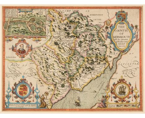
* Monmouth. Speed (John), The Countye of Monmouth with the situation of the Shire-towne Described, John Sudbury & George Humble, circa 1627, engraved map with early hand-colouring, inset town plan of Monmouth, large strapwork cartouche and mileage scale, additional faint vertical fold, 385 x 510 mm, mounted, framed and double-glazed, English text on versoQTY: (1)
Lot 19
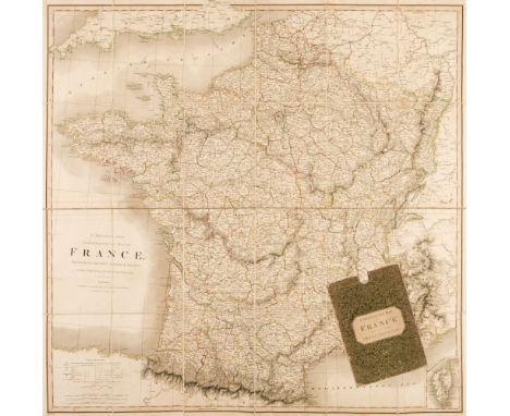
Folding Maps. A Collection of Seven Maps, mostly 19th century, including Smith (C.). A Physical and Topographical map of France, Describing the Post Roads & Relays with the Inland Navigation &c. 1st March 1824, engraved map with contemporary outline colouring, sectionalised and laid on linen, slight offsetting, 800 x 810 mm, contained in a contemporary marbled card slipcase with printed label to the upper cover, slight wear to extremities, together with Keller (Heinrich). Aussicht vom Weissenstein auf dem Jura, Cant. Solothurn, gezeichnet und herausgegehen van J. J. Scheurmann, Zurich, 1818, engraved panorama of the Alpes, with aquatint and contemporary outline colouring, 170 x 1900 mm, engraved aquatint view to rear pastedown, publishers marbled boards with contemporary printed labels to verso and recto, slight wear to extremities, with Gell (Sir William). Rome & its Environs from a Trigonometrical Survey, Sauders & Otley, 1834, engraved map with contemporary outline colouring, sectionalised and laid on linen, two splits along old folds, slight staining, 725 x 975 mm, near contemporary dated ownership signature to verso, Estcourt library label to rear pastedown, bound in contemporary morocco gilt boards, plus Bacon (G. W. publisher). Bacon's Library Map of Yorkshire Reduced from the One-Inch Ordnance Survey to half the Scale - Two Miles to the Inch, circa 1870, large lithographic folding map with contemporary wash colouring, sectionalised and laid on linen, inset plan of Leeds, calligraphic cartouche, short splits to old folds, 1275 x 1600 mm, marbled endpapers, bound in contemporary half sheep gilt, worn and frayed with some loss to the spine, and Wilson (Captain Charles W. under the Direction of Colonel Sir Henry James R. E. Director of Ordnance Survey). Ordnance Survey of Jersusalem, 1864 - 65, uncoloured engraved map, sectionalised and laid on linen, 1150 x 730 mm, contained in a contemporary blue cloth slipcase with printed label with manuscript title to the upper siding, very slight wear to extremities, with a folding map of India and one other similarQTY: (7)
Lot 226
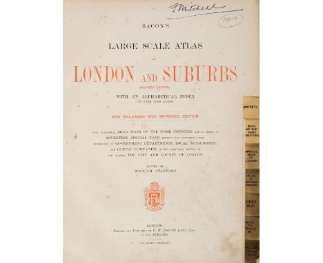
Bacon (G. W., publisher). Bacon's Large Scale Atlas of London and Suburbs (Revised Edition) with an Alphabetical Index, circa 1910, title page and contents list, 26 double-page and folding social, geographic and industrial maps and a 34-sheet map of Greater London, slight spotting and occasional closed tears, marbled endpapers, publisher's cloth gilt, stained, frayed and worn, folioQTY: (1)

Lot 219
Bentley Car interest ; Prototype original scale hand built model. Remarkably wonderful Prototype factory 15” long model , white Livery and exact scaled detailed both outside and inside. The plinth measure 18” x 9” across and the car model itself is 15” long. Built accurately, including the interior ,the weight is considerable., and is on a fixed weighted plinth for display. There are some teeny flaws across the vehicle and it lacks a tiny fin wiper inset in to the front screen. Fabulous Model for any Bentley enthusiast.
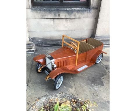
Lot 216
Volvo Fine Remarkably craftsman built wooden Built Childs Scale Vintage pedal car ; Magnificently hand turned and engineered scale model for a young child modelled as a GF Volvo pre war model, with working pedals, adjustable upholstered seat with windscreen and working steerable wheel. The dimensions are 43” long x 19”wide x 20” Height to top of windscreen. The quality of the built is fine and a good Heirloom collectible rare toy ; An exceptional toy car and is a heavy durable build for a long term toy for Many children to use long term. Built by a highly skilled meticulous car engineer as a replica useable model, with smooth ease of use pedals . Please see all images.


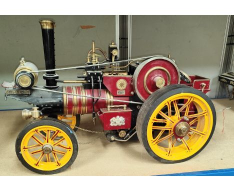
Lot 313
Markie Models: 1/10th scale live steam model of a Burrell Showman's engine No. Arj-2064, name plate Sheila, with spare chimney and roof, 'Ray Daniels Poynton' in maroon livery, yellow wheels, length 55cm (from deceased's estate - not known when last used, no box or papers)Length 58cm long x 36cm high

Lot 62
FOUR TURNED AND EBONISED WOOD 'YARD STICK' STANDARD LAMPS BY ANOUSKA HEMPEL With ring turned columns 157cm high to the top of the lamp columnSaleroom Notice: please note there are no shades with this lot. ELECTRICAL GOODS. These are sold as decorative items only, with plugs removed, and if bought for use must be checked over for compliance with safety regulations by a qualified electrician before use. Condition Report: One bulb holder is incomplete, one with a scuff, one candle is dirty and slightly marked, one photo for scale and these are not sold with shadesAll electrical items are sold with no plugs and are for decorative purposes only Condition Report Disclaimer
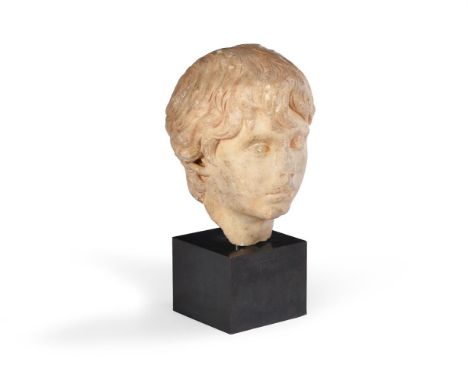
Lot 72
A CARVED MARBLE PORTRAIT HEAD OF A YOUTH, PROBABLY POLIDEUCE ROMAN, POSSIBLY CIRCA 170-177 AD Now set on brass stem and metal base the head 28cm high, 21cm wide, 39cm high overall Provenance: Mallett, 1980s Polideuce (sometimes spelled Pollùce, Polydeukes and Polydeukion) was the pupil of the wealthy politician and philosopher Herodes Atticus (101-177 AD). It is usually understood that the two had a love affair and, when Polydeuce died in 173-174, Herodes began a process of very public grieving, erecting statues and monuments to his pupil and declaring him to be "eroe" (a hero) in mimicry of Hadrian's similar treatment for his beloved Antinous. The veneration of deceased private citizens as "Heroes" was not uncommon at this time, but the scale of Herodes very public display of grief earned him derision and mockery within his own lifetime. In truth, he had commissioned similarly large-scale public displays of devotion when his adopted son Memnon and his wife Regilla had passed away. For similar please see: The bust-portrait held in the Regional Archaeological Museum of Palermo (N.I 1520). Catalogued as "Ritratto di Polydeukion, giovinetto favorito di Erode Attico". The portrait bust of Polydeukes, "favourite of Herodes Atticus" in the Sir John Soane's Museum (M517) Another bust is held in the National Archaeological Museum of Athens (4811). Condition Report: A CARVED MARBLE PORTRAIT HEAD OF A YOUTH, PROBABLY POLIDEUCE ROMAN, POSSIBLY CIRCA 170-177 AD Now set on brass stem and metal base the head 28cm high, 21cm wide, 39cm high overall Provenance: Anouska Hempel. Shaw House in Wiltshire. Purchased by her in the 1980s from Mallet. She would be happy to provide a letter confirming this to the successful purchaser.Sale details: As per cataloguing- this head is now set on a modern stem and base- with some remedial work to stone junction point visible under UV. Slight colour variance under UV to chin, mouth and nose as well. This may be because of surface exposure from wear or may indicate mild stabilisation remedial work.Overall- wear notably to nose, chin, mouth, left eye, left eyebrow, and with scratches, knocks and losses. The whole slightly paler red- sandstone colour notably to crevices. We thank Joanna van der Lande for her help cataloguing this lot.Please see additional images for visual references to condition which form part of this condition report. All lots are available for inspection and Condition Reports are available on request. However, all lots are of an age and type which means that they may not be in perfect condition and should be viewed by prospective bidders; please refer to Condition 6 of the Conditions of Business for Buyers. This is particularly true for garden related items. We must advise you that we are not professional restorers or conservators and we do not provide any guarantee or warranty as to a lot's condition. Accordingly, it is recommended that prospective buyers inspect lots or have their advisors do so, and satisfy themselves as to condition and accuracy of description All lots are offered for sale "as viewed" and subject to the applicable Conditions of Business for Buyer's condition, which are set out in the sale catalogue and are available on request. Buyers are reminded that liability for loss and damage transfers to the buyer from the fall of the hammer. Whilst the majority of lots will remain in their location until collected, we can accept no responsibility for any damage which may occur, even in the event of Dreweatts staff assisting carriers during collection. Condition Report Disclaimer

Lot 369
Scotland. John Crane Dower & T. Harwood after F.A. & G.W. Carrington - A Map of Scotland, Divided into Counties shewing (sic) The principal Roads, Railways, Rivers, Canals, Lochs, Mountains, Islands, &c. on a Scale of Five Miles to an Inch, London: Published by S. Lewis & Co., 1846, being the supplementary map volume to Lewis's Topographical Dictionary of Scotland, title-page and contents leaf, engravings on six folding sheets, some stable cross-section tears, but stable, some foxed spots, original publisher's cloth, gilt-lettered, 4to

Lot 629
Derek Carruthers (1935-2021) - Wall Relief 1970-71, fibreglass, wood and paint, signed and dated on the reverse, 152 x 214cm "Nine fibreglass panels with ontrusions - five larger forming an axial cross - smaller protrusions on four panels suggesting a clockwise movement" A one third scale maquette for the wall relief commissioned by Leicester University, 1971 Good condition
-
186097 item(s)/page