We found 216136 price guide item(s) matching your search
There are 216136 lots that match your search criteria. Subscribe now to get instant access to the full price guide service.
Click here to subscribe- List
- Grid
-
216136 item(s)/page

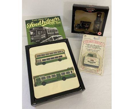
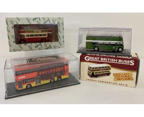
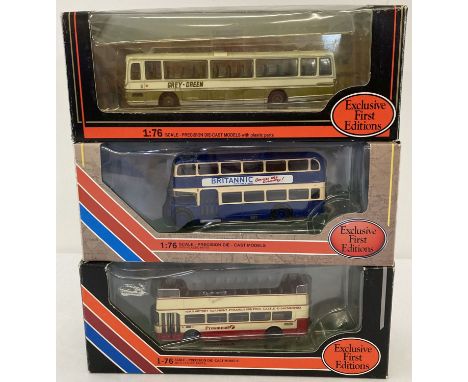
Lot 418
3 assorted boxed diecast vehicle sets from Matchbox, Lledo and Exclusive First Editions. Comprising: sealed blister packed Matchbox originals recreations No. 4 Massey Harris Tractor, Lledo collectable Cockburn's Special Reserve Port gift set and E.F.E Last Days of Southdown 2 vehicle set with Bristol VR series III & Leyland National in 1:76 scale.
Lot 336
Depping (George Bernhard). L'Angleterre ou Description historique et topographique du Royaume Uni de la Grand-Bretagne, 6 volumes, 2nd edition, Paris: chez Etienne Ledoux, 1828, engraved title and additional half-title to each volume, folding contents list and decorative engraved scale, folding map of the British Isles and 58 engraved maps (complete) each with contemporary outline colouring, 19 engraved with aquatint topographical views, and an engraved plate of music, volume 6 with a duplicate map hinged-in behind title (adhesive yellowing), letterpress variably spotted (rarely affecting maps), maps and plates somewhat offset to text, occasional pale dampstaining at head, each front pastedown with calligraphic ink manuscript school prize bookplate, near contemporary maroon sheep gilt, gilt emblem of 'Institution Landry' to each front cover, rubbed with a little wear to extremities, some minor surface losses, spines faded, 12moQty: (6)
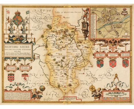
Lot 451
* Bedfordshire. Speed (John), Bedford Shire and the Situation of Bedford described with the armes of thos Honorable Familyes that have borne ye titles of Dukes and Earls thereof, George Humble [1616], hand-coloured engraved map, an inset town plan of Bedford, large strapwork cartouche and mileage scale, slight text show through, 385 x 510 mm, Latin text on verso, mounted, framed and double-glazedQty: (1)
![* Belgium. Ortelius (Abraham), Leodiensis Dioecesis Typus, [1595 or later], engraved map with contemporary hand colouring, el](https://cdn.globalauctionplatform.com/773a2f63-986c-4cc6-9db3-ad1200b50a92/aadf8396-f40d-401c-bdf0-ad1301259a82/468x382.jpg)
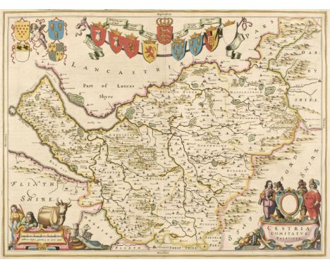
Lot 462
Cheshire. Blaeu (Johannes), Cestria comitatus Palatinus, Amsterdam, circa 1648, engraved map with contemporary outline colouring, decorative cartouche and mileage scale, 385 x 505 mm, Latin text on verso, mounted, together with Moule (Thomas). Cheshire, circa 1848, hand-coloured engraved map, slight overall toning, 200 x 260 mm, mounted, framed and glazedQty: (2)
![China. Jansson (Jan), China veteribus Sinarum Regnum nunc Incolis Tame Dicta, Amsterdam, l1640 or later], engraved map with c](https://cdn.globalauctionplatform.com/773a2f63-986c-4cc6-9db3-ad1200b50a92/38bae9a7-51e9-4733-8e17-ad130125a36c/468x382.jpg)
Lot 465
China. Jansson (Jan), China veteribus Sinarum Regnum nunc Incolis Tame Dicta, Amsterdam, l1640 or later], engraved map with contemporary outline colouring, decorative cartouche and mileage scale, toned overall, some oxidisation to old watercolour with slight cracking affecting the image, 410 x 495 mm, Latin text on versoQty: (1)NOTESThe map shows the eastern part of China, with the Great Wall in the north-west. The fictitious Chaimay Lacus is shown on the western border with numerous rivers flowing south into India and Siam. Korea is erroneously shown as an island and Japan is distorted and consists of only three islands. Taiwan is named as Pakan al I. Formosa. The map was one of the first to update Ortelius's map of 1584 and the revisions were largely based on more up to date Jesuit surveys.
![Europe. Hondius (Jodocus), Nova Europae Descriptio Auctore, Amsterdam [1619 - 28], hand-coloured engraved map, strapwork cart](https://cdn.globalauctionplatform.com/773a2f63-986c-4cc6-9db3-ad1200b50a92/8cf24c4a-7e7f-4d02-94c2-ad130125a8f4/468x382.jpg)
Lot 486
* Hampshire. Saxton (Christopher), Southhamtoniae comitatus (preter Insulas Vectis Jersey et Garnsey quae sunt partes eiusdem comitatus) cum suis undigs consinibus Oppidis pagis Villis et Fluminibus vera descriptio, circa 1579, engraved map with contemporary hand colouring and some later enhancement, large strapwork cartouche and mileage scale surmounted by the royal crest of Elizabeth I, with the additional coat of arms of Thomas Seckford, engraved by Leonardus Terwoort, two repaired closed tears just affecting the image in the lower margin, 400 x 440 mm, mounted, framed and glazedQty: (1)NOTESThe first printed map of Hampshire
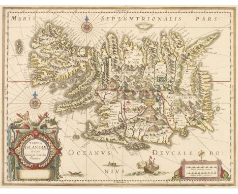
Lot 490
Iceland. Jansson (Jan), Tabula Islandiae Auctore Georgio Carolo Flandro, circa 1650, engraved map with contemporary hand-colouring, large decorative cartouche and mileage scale, compass rose and numerous rhumb lines, central fold partially split and repaired on verso, 380 x 500 mm, French text on versoQty: (1)
![Mexico. Mercator (Gerard), Hispaniae Novae Nova Descriptio, [1606 or later], engraved map with contemporary hand-colouring, l](https://cdn.globalauctionplatform.com/773a2f63-986c-4cc6-9db3-ad1200b50a92/a50323b0-b10d-4368-bbc2-ad130125be6a/468x382.jpg)
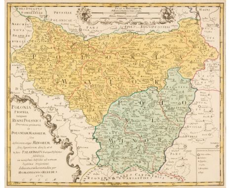
Lot 520
Poland. Homann (J. B. heirs of), Polonia Propria tanquam Regni Polonici..., 1772, engraved map with contemporary hand-colouring, uncoloured strapwork cartouche and mileage scale, large margins, 420 x 490 mm, together with Rizzi Zannoni (Giovanni Antonio Bartolomeo). Carte Generale de la Pologne avec tous les Etats qui en dependent, Paris, circa 1780, engraved map with contemporary outline colouring, uncoloured decorative cartouche and mileage scale, 325 x 460 mm, with another copy similar, with Zatta (Antonio). La Pologne divisee en ses Palatinats selon la dernier condivision des Tris Puisances Sovoire L'Autriche, La Russie, La Prussw, Venice, 1802, engraved map with contemporary outline colouring, slight staining to central fold, short split at base of central fold, 500 x 655 mm, plus Gussefeld (Franz Ludwig). Charte von Polen nach den Bewährtesten Hültsmitteln dem Theilungs Tractat vom Jahr..., 1806, engraved map with contemporary outline colouring, some near-contemporary underlining of principal towns and cities, 485 x 525 mm, and another four unattributed maps of Poland, various sizes and conditionQty: (9)
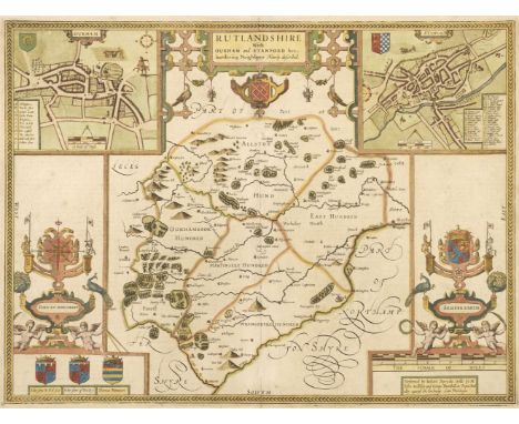
Lot 524
Rutland. Speed (John), Rutlandshire with Oukham and Stanford her bordering Neighbour Newely described, 1st edition, 1611, hand-coloured engraved map, inset town plans of Oakham and Stanford, large strapwork cartouche and mileage scale, 390 x 515 mm, English text on versoQty: (1)NOTESA bright clean example.
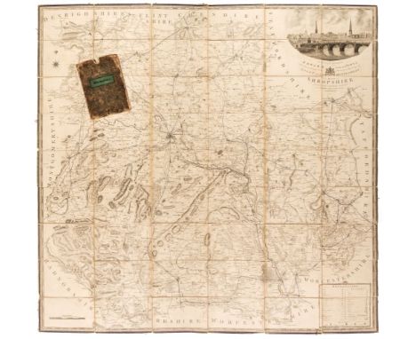
Lot 532
Shropshire. Baugh (Robert), To the Right Honourable Edward Earl of Powis Lors Lieutenant and Custos Rotulorum of the Counties of Salop and Montgomery, This Map of Shropshire is humble and respectfully dedicated by His Lordship's obliged and obedient Servant..., Robert Baugh, Llanymynech, Shropshire [1st August 1808], engraved large scale map, sectionalised and laid on linen, sparse later 19th-century outline colouring highlighting the railways, large calligraphic cartouche surmounted by a view of English Bridge in Shrewsbury, table of explanation and mileage scale, slight staining, edged with blue silk which is frayed in places, marbled endpapers, 1395 x 1420 mm, contained in a contemporary marbled slipcase with a printed label to the upper cover, slipcase worn and frayedQty: (1)NOTESThe first and only edition of this scarce map of Shropshire.
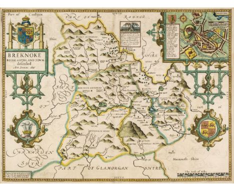
Lot 541
* Wales. Speed (John), Breknoke both Shyre and Town described, John Sudbury & George Humble, circa 1627, hand-coloured engraved map, an inset town plan of Brecknock, large strapwork cartouche, slight text show through, 385 x 510 mm, framed and double-glazed, English text on verso, together with Saxton (Christopher & Kip W.). Merioneth comitatus olim pars Ordovicum, circa 1610, hand-coloured engraved map, large strapwork cartouche and mileage scale, 265 x 320 mm, mounted, framed and glazedQty: (2)
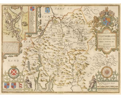
Lot 544
Westmorland. Speed (John), The Countie Westmorland and Kendale the Cheif Towne Described, Thomas Bassett & Richard Chiswell [1676], hand-coloured engraved map, an inset town plan of Kendal, large strapwork cartouche, compass rose and mileage scale, slight mount staining, 385 x 510 mm, English text on versoQty: (1)
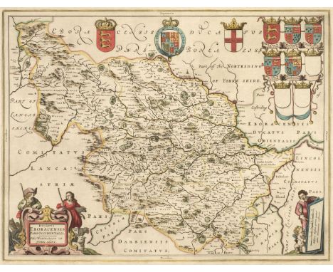
Lot 549
Yorkshire. Blaeu (Johannes), Ducatus Eboracensis pars Occidentalis; The West Riding of Yorkshire, Amsterdam, circa 1648, engraved map with contemporary outline hand-colouring, decorative cartouche and mileage scale, slight staining to margins but not affecting image, 390 x 505 mm, Dutch text on verso, together with Ducatus Eboracensis pars Orientalis; The East Riding of Yorkshire, Amsterdam circa 1646, engraved map with bright contemporary hand- colouring, slight creasing along central fold, 385 x 510 mm, French text on versoQty: (2)
Lot 328
A pair of Booth's earthenware Worcester style shaped oval dishes, early 20th c, printed and painted with reserves of birds and flowers on a scale blue ground, gilt foliate detail, 30cm w, unmarked Minor crazing to base on one dish, other light scratches and wear with minor rubbing to decoration in places generally consistent with age
Lot 354
A Coalport Coalbrookdale floral encrusted 'scale cologne bottle on tripod plinth' and stopper, c1835, painted to either side with a bird on a branch, and insects between turquoise and gilt borders, 23cm h, underglaze blue Coalport. Typical chipping of the petals and leaves but no substantial damage

Lot 295
A pair of German porcelain bulb pots and bases after a Sevres vase hollandois, c1900, painted with elegant 18th c figures in a landscape alternating with bright scale blue reserves, 20cm h, pseudo AR monogram and gilder's 15 One vase restored, the other and bases in good condition, some slight wear to gilding

Lot 171
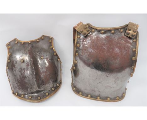
19th Century Life Guards Pattern Breast and Backplatesteel breastplate with raised central rib. Brass edging with brass stud decoration. Rear with traces of leather edging. Matching backplate. Lower section with broad arrow issue marks. Complete with brass scale shoulder straps (some repairs). Some cracks and light rusting.
Lot 499
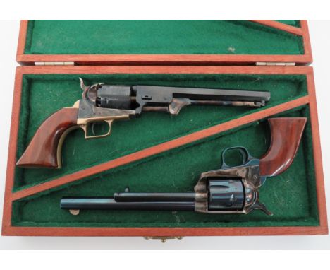
Two Modern Miniature Colt Revolversconsisting Colt Navy revolver. 3 1/2 inch, blued, octagonal barrel. Lower loading rod. Engraved shot cylinder. Case hardened body and hammer. Brass trigger guard and grip frame. Polished wooden grip ... Colt Peacemaker revolver. 3 1/2 inch, blued barrel with side mounted clearing rod. Blued, fluted cylinder. Case hardened body and hammer. Blued trigger guard and grip frame. Polished wooden grip. Both contained in their polished wooden box. Excellent scale models.
-
216136 item(s)/page