We found 216134 price guide item(s) matching your search
There are 216134 lots that match your search criteria. Subscribe now to get instant access to the full price guide service.
Click here to subscribe- List
- Grid
-
216134 item(s)/page

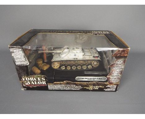
Lot 429
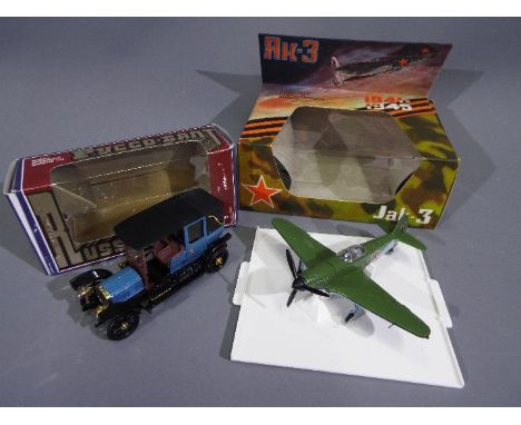
Russian Diecast - 2 x vintage boxed models, a 1941 Yakolev Yak-3 WWII fighter plane in 1:72 scale and a 1909 Russo-Balt 24/30 Limousine in 1:43 scale. Both models appear Mint, the Yak fighter in a Near Mint box with only some very light rub marks and the Russo-Balt car is in a Very Good box with light storage wear. (This does not constitute a guarantee) (2)
Lot 110
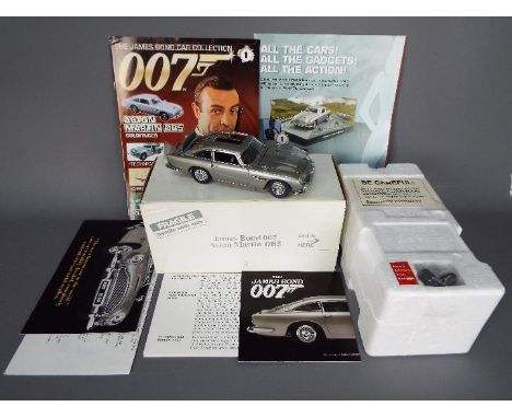
Danbury Mint - A boxed Danbury Mint 1:24 scale James Bond 007 Aston Martin DB5. This iconic and highly detailed model appears to be in Mint condition housed in Mint original polystyrene inner, presented in an Excellent external white cardboard Danbury Mint box with some storage wear. The model also comes with Danbury Mint certificate and paperwork. (2)(This does not constitute a guarantee)
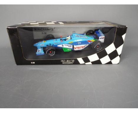
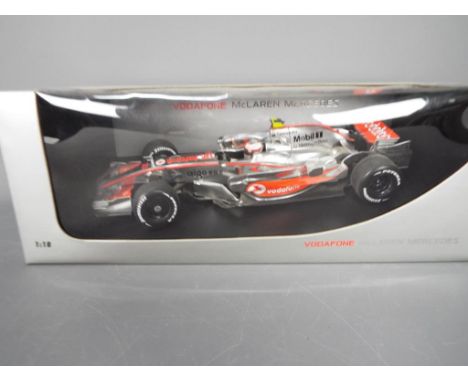
Lot 471
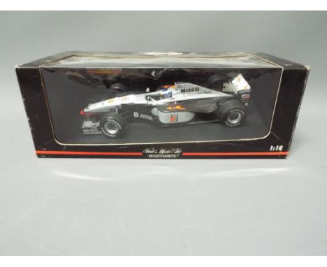
Minichamps - A boxed 1:18 scale Minichamps # 530981808 McLaren MP4/13 'M.Hakkinen' Formula 1 Racing Car. The model appears Near Mint and has a broken antenna which is contained within the box, and is housed in a Fair Plus dusty window box with some storage imperfections. (This does not constitute a guarantee)
Lot 44
Corgi Aviation Archive - Easy Model - 2 x boxed models in 1:72 scale, a limited edition # 49403 English Electric Lightning F3 5 Sqn 1978 number 179 of 6800 produced, # 3642 Messerschmitt Komet Me163B-1a. Both models appear Mint, the Lightning is in a Poor box with storage wear and a torn underside, the Komet is in a Good box with light storage wear. (This does not constitute a guarantee) (2)
Lot 225
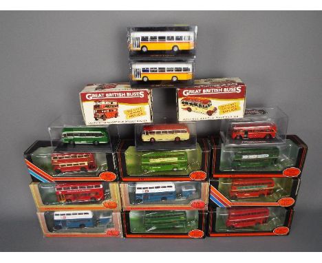
EFE, Corgi - A fleet of 20 boxed diecast model vehicles predominately EFE 1:76 scale buses. Lot includes EFE #23203 AEC RF 'London Country'; #23204 AEC RF Mk.II 'Greenline' ; #27806 AEC London STL Bus 'Premier Travel' and similar. Models appear to be in Mint condition in Very Good - Excellent dusty boxes with storage wear imperfections. (This does not constitute a guarantee)
Lot 73
Oxford Diecast, Atlas Editions, Matchbox, Vanguards, Corgi Juniors - A mixed collection of boxed diecast model in various scales plus a plastic model kit and kit built slot car. Lot includes Oxford Diecast 1:72 scale DH89 Dragon Rapide aircraft; Atlas Editions 1:43 Mercedes 300SL 1954; Vanguards Morris Minor Traveller; Matchbox PK6605 AMT Logging Trailer and similar. Diecast appear Excellent - Mint in generally Fair - Good boxes with storage and age related imperfections. Slot car kit is in unassociated Revell box. Plastic Matchbox kit appears Good in sealed bag with instructions and is unchecked for completeness.

Lot 43
Corgi Predators Of the Skies - 2 x boxed limited edition 1:72 scale models, # PR99402 Grumman F6F-5 Hellcat flown by Commander David McCampbell number 1242 of only 4760 produced, # PR99403 Grumman TBF-1C Avenger flown by Lieutenant George H.W. Bush number 4506 of only 4760 produced. Both models appear Mint in Very Good boxes with light storage wear. (This does not constitute a guarantee) (2)
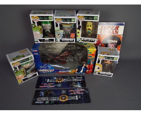
Lot 79
Joyride, Funko Pop, Other - A mixed lot which includes a boxed Joyride diecast Limited Edition 1:10 scale 'American Chopper The Series' 'Black Widow' appears Mint in Fair plus window box; Five vinyl; Funko Pop figures including Rick, Morty, Western Morty and similar which appear Mint in Excellent boxes with a Funko Pop Super Conan boxed T-Shirt; and two carded Star Wars 'Feel the Force' watches which appear Mint on Mint cards.
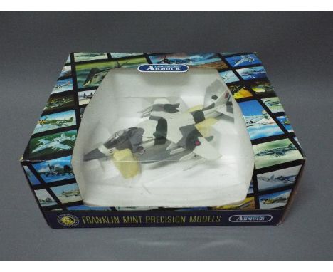
Lot 62
Franklin Mint - A boxed Franklin Mint 'Armour Collection' 1:48 scale B11E764 AV8 Harrier GR3 (RAF). The model appears in Mint condition housed in Near Mint polystyrene inner box, presented in an Excellent dusty box with some storage and age related wear. (This does not constitute a guarantee)
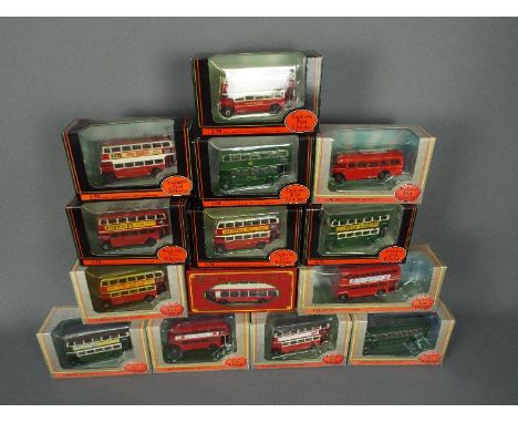
Lot 231
ABC Models, EFE - 14 boxed diecast 1:76 scale model buses. Lot includes ABC Models TRA 5001A Alexander Double Deck 'Harrow Bus'; EFE #27810 AEC STL 'London Transport'; #30303 Routemaster Prototype RM2 'London Transport' and similar. Models appear Mint in Very Good - Excellent dusty boxes with some storage imperfections. (This does not constitute a guarantee)
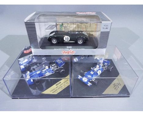
Lot 440
Quartzo - 3 x boxed racing cars in 1:43 scale, # QLM033 a limited edition Jaguar C Type 1953 Le Mans winning car number 4122 of only 5000 produced, # 4035 Tyrrell 001 1970 USA GP car, # 4046 Tyrell 003 1971 British GP car. The vehicles all appear Mint in Good boxes. (This does not constitute a guarantee) (3)
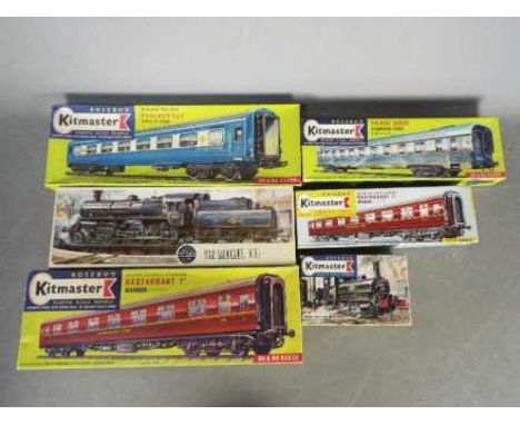
Lot 132R
Airfix, Kitmaster - Six boxed vintage plastic OO scale railway model kits. Lot includes Airfix R403 BR Mogul locomotive (part built) Kitmaster #6 Saddle Tank engine; Kitmaster #29 French Coach# Kitmaster #28 BR Standard Restaurant Coach (assembled) and similar. Majority of kits appear to have loose parts and parts on sprues and are unchecked for completeness, and are presented in boxes which appear to be Good overall with age and storage related wear. (This does not constitute a guarantee)
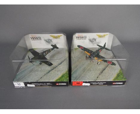
Lot 35
Corgi Aviation Archive - 2 x boxed 1:72 scale WWII Legends series models, # AA33105 Mitsubishi A6M3-11 Zero flown by CPO Takeo Okumura, # AA32104 Messerschmitt BF 109E-1 flown by Staffelkapitan Eduard Neuman. Both models appear Mint in Near Mint display boxes with only very light storage marks. (This does not constitute a guarantee) (2)
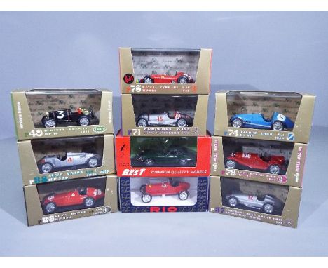
Lot 438
Rio - Model Best - A collection of 10 x boxed racing cars in 1:43 scale including # HP270 1955 Lancia-Ferrari D50, # HP40 1921 Bugatti Brescia, # 9014 Jaguar E Type Coupe and other similar models. The cars all appear Mint in Very Good display boxes with light storage wear. (This does not constitute a guarantee) (10)
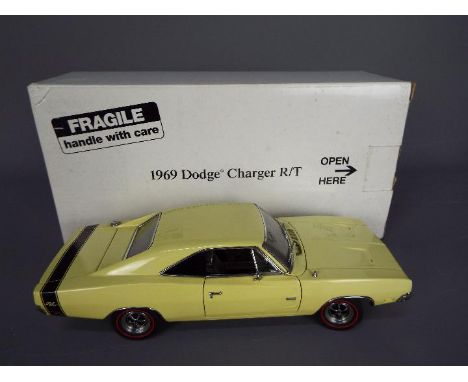
Lot 115
Danbury Mint - A boxed Danbury Mint 1:24 scale 1969 Dodge Charger R/T. The model in pale yellow appears to be in Mint condition housed in Mint original polystyrene inner, presented in an Excellent external white cardboard Danbury Mint box with some storage wear. The model is without paperwork. (This does not constitute a guarantee)

Lot 439
Matchbox Dinky - Vitesse - A collection of 11 x boxed cars in 1:43 scale including # 27750 limited edition Lotus Elan open top in Norfolk Yellow number 2430 of only 4224 produced, # DY-20 Triumph TR4A, # DY-19 MGB GT V8. The white Lotus Elan has some marks on it, the other vehicles all appear Mint. The boxes all appear in Good condition with some storage wear. (This does not constitute a guarantee) (11)
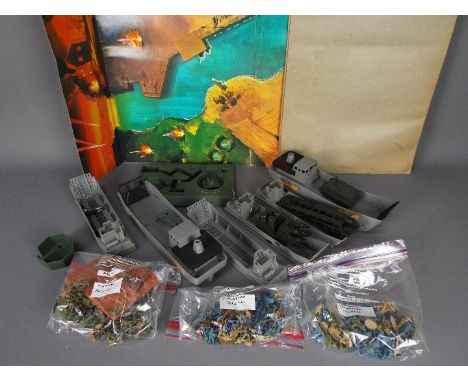
Lot 341
Airfix, Matchbox - A vintage unboxed HO/OO scale Airfix Gun Emplacement set with a a large quantity of unboxed Airfix Ho/OO scale plastic soldiers including British Infantry, American ang German Infantry figures, with 4 unboxed Matchbox PS2 Landing Craft and 2 unboxed Matchbox G17 '607 Commando' Ferry Boats. All items are in Playworn condition generally appearing Fair - Good overall and unchecked for completeness. The lot also comes with 2 Matchbox Beach Head Assault play mats - both in unboxed Fair - Good condition with creasing and age related wear. (This does not constitute a guarantee)
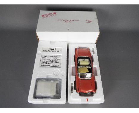
Lot 117
Danbury Mint - A boxed Danbury Mint 1:24 scale 1957 Cadillac Eldorado Biarritz. The model in pink appears to be in Mint condition housed in Mint original polystyrene inner, presented in an Excellent external white cardboard Danbury Mint box with some storage wear. The model is without paperwork. (This does not constitute a guarantee)
Lot 71
Atlas Editions, EFE, Corgi Original Omnibus, Other - A collection of 16 boxed diecast 1:76 scale model buses. Lot includes EFE #36201 RMA Routemaster & Trailer 'British European Airways'; EFE #25603 RCL Routemaster Coach 'Greenline'; Atlas Editions London Transport RTW Double Decker and similar. Models appear Mint in Fair Plus - Very Good boxes wioth storage wear and imperfections - some of models appear to be missing outer boxes packaged only in perspex cases. (This does not constitute a guarantee)
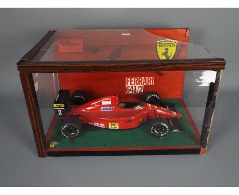
Lot 77
Tamiya - A built vintage 1:12 'Big Scale Series' plastic model kit #25 by Tamiya of a Ferrari 641/2 F1 racing car. The kit which has some damage and loose parts appears to have been constructed to a Good standard and is contained within a perspex and wood display case / diorama measuring approximately 26 cms (H) x 43 cms (W) x 29 cms (D), which has a break to the top, a crack in one side and missing the other side. A lot which requires some TLC or for use as spares / repairs. Due to the fragile nature of the model and display case please contact Client Services to discuss delivery options available.
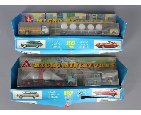
Lot 234
EKO - Two boxed EKO Micro Miniatures HO / 1:86 scale plastic vehicle sets. Each set contains two commercial vehicles which appear to be in Mint condition. Boxes are in Poor dusty condition with crushing and tears to the cardboard, and surface wear to bubble packs. (2) (This does not constitute a guarantee)
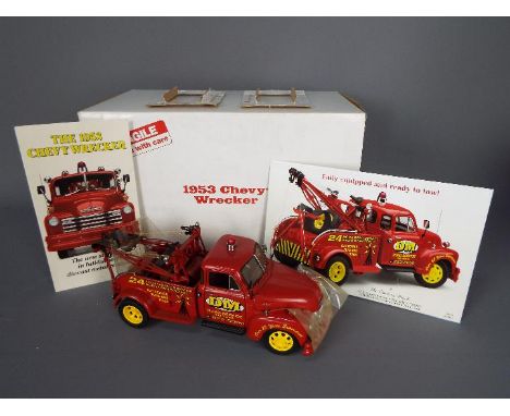
Lot 107
Danbury Mint - A boxed Danbury Mint 1:24 scale 1953 Chevy Wrecker. The model appears to be in Mint condition housed in Mint original polystyrene inner, with internal packaging pieces, presented in an Excellent external white cardboard Danbury Mint box with some storage wear. The model also comes with Danbury Mint paperwork. (This does not constitute a guarantee)
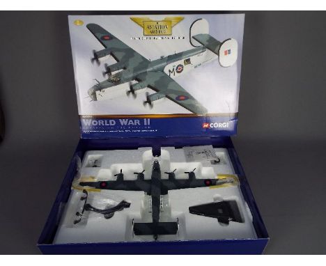
Lot 34
Corgi Aviation Archive - 3 x boxed models, # AA32001 Hawker Hurricane MkII BE421 in 1:72 scale , # 47302 AVRO Lancaster RAF Coastal Command 1st issue in 1:144 scale, # 49801 Hawker hunter FGA9 in 1:72 scale. All the models appear Mint, the Hurricane box is Poor, the other two are in Fair boxes, the Hurricane has a certificate to show its number 127 of only 3900 produced. (This does not constitute a guarantee) (3)
Lot 414
Singer Thomas Meighan signed 12x8 colour photo in excellent condition. Thomas Peter Meighan is an English singer and musician, best known as the former lead vocalist for the rock band Kasabian. He enjoyed large scale success with Kasabian in the 2000s and 2010s. He is said to have an intense, frenetic personality both on and off stage. Good condition Est.
Lot 406
Singer Thomas Meighan signed 12x8 colour photo in excellent condition. Thomas Peter Meighan is an English singer and musician, best known as the former lead vocalist for the rock band Kasabian. He enjoyed large scale success with Kasabian in the 2000s and 2010s. He is said to have an intense, frenetic personality both on and off stage. Good condition Est.
![[MAP]. GREAT BRITAIN Homann, Johann Baptist (German, 1664-1724). 'Magnae Britanniae pars meridionalis, in qua Regnum Angliae](https://cdn.globalauctionplatform.com/8beb918b-dfc0-48e9-b206-adcd00ad9fc4/bf185690-79e7-44c9-bb4b-add000a6db33/468x382.jpg)
Lot 650
[MAP]. GREAT BRITAIN Homann, Johann Baptist (German, 1664-1724). 'Magnae Britanniae pars meridionalis, in qua Regnum Angliae tam in septem antiqua Anglo-Saxonum Regna...', engraved map, hand-coloured, 62.5cm x 52.5cm, framed and glazed. Condition Report : Generally good condition; minor browning to right upper and lower corners; partially erased pencil notations to bottom left margin; 1cm slit, without loss, above scale; fresh colours. Condition reports are offered as a guide only and we highly recommend inspecting (where possible) any lot to satisfy yourself as to its condition.
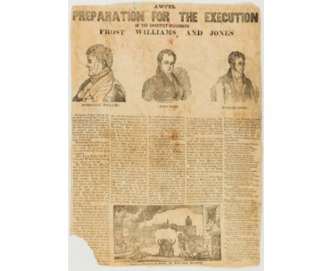
Lot 151
Broadside.- Newport Rising.- Awful Preparation for the Execution of the Chartist Prisoners Frost Williams, and Jones, c.455 x 330 mm., woodcut illustrations, slight chipping and fraying to right edge, partially strengthened, small loss to bottom left corner, affecting text, light soiling, foldine, H. Paul, c.1840.⁂ Rare. This appears to be unrecorded. The Newport Rising, led by Zephaniah Williams, John Frost and William Jones, was the last large-scale armed protest held in Britain. They were seeking democracy, the right to vote and a secret ballot. The leaders, Williams, Frost and Jones were the last people in England and Wales to be sentenced to be hanged, drawn and quartered for high treason. After a nationwide petition, the government eventually commuted the sentences of each to transportation to Tasmania for life.
Lot 42
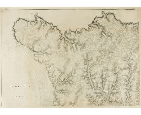
NO RESERVE Jersey.- [Survey of the Island of Jersey, taken by order of his Grace the Duke of Richmond, Master-General of the Ordnance], detailed military survey of Jersey, scale of six inches to the mile, 3 sheets only (of 4), lacking SW sheet, engravings, each sheet approx. 725 x 1030 mm (28 1/2 x 40 1/2 in), good margins, minor surface dirt, light spotting, handling creases, rolled, [1787-1795].⁂ Scarce.

Lot 132
A finely etched sentoku (brass alloy) cabinet modelled as a miniature nijunoto (two-storey pagoda)By Fujii Yoshitoyo (Biho, born 1868) of Kyoto, Meiji era (1868-1912), late 19th/early 20th centuryWorked predominantly in his renowned etching technique with strands of gold and silver overlaid on the sentoku with extensive chased details, constructed on two storeys raised on an integral stepped base, each storey beneath a sloping roof, the upper roof fitted with one removable drawer, the lower roof with two drawers, all with chrysanthemum bud handles, the upper roof decorated with ho-o birds, dragons, a temple complex and a bird among peonies surmounted by a tall stupa with a tama-shaped knop from which chains lead down to the roof's corners, the lower roof similarly decorated, the sides around the base with repeated foliate and geometric patterns, stamped on the base with the Mount Fuji mark of Fujii Yoshitoyo; on its original, detachable, stepped wood stand. The pagoda: 18.5cm (7¼in) high. (2).Footnotes:Fujii Yoshitoyo, founder of the Fujii Damascene Company, was most famous for his 1/50 scale model of the Kinkakuji in Kyoto, sent to the Japan-British Exhibition in 1910, which is said to have taken him four years to complete, see Mochizuki Kotaro, Japan To-Day: A Souvenir of the Anglo-Japanese Exhibition Held in London 1910, (Special Number of the Japan Financial and Economic Monthly), p.587.For further information on this lot please visit Bonhams.com
Lot 1518
Pair of Booths ovoid vases and covers, decorated in reserve panel with floral sprays and exotic birds in Worcester style blue scale and gilt ground H17cm, a pair of C19th campana shaped vases, painted with rural scenes, painted mark No.186 H12cm, another similar vase decorated with floral sprays, painted mark No.86, a pair of French porcelain baluster vases Chinoiserie decorated in gilt and a pair of Lynton porcelain bough pots decorated in Spode style with a floral spray (9)
Lot 1526
Garniture of three Worcester style vases decorated with exotic birds amidst foliage in reserve panels on a blue scale and gilt ground, comprising two tapering square vases and covers, a hexagonal vase and cover, all with Pseudo-Chinese marks, and a pair of French oriental style porcelain vase decorated with exotic bird in shaped reserve panels on blue and gilt ground, H31cm max (5)
Lot 406
FOUR FRANKLIN MINT DIECAST MODEL FIRE SERVICE VEHICLES comprising a 1/32 scale 1922 Ahrens-Fox R-K-4 Pumper; 1/24 scale 1912 Christie Front Drive Steamer; 1/16 scale 1916 Ford Model T Fire Car; and 1/32 scale American LaFrance Series 700 Fire Engine, each mint or near mint and in original packaging, (Ahrens-Fox lacking outer box for polystyrene case).
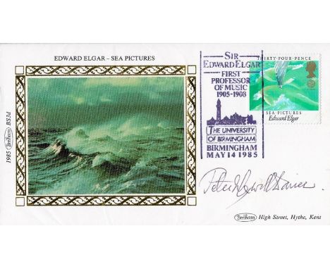
Lot 52
Sir Peter Maxwell signed Benham Edward Elgar Sea Pictures FDC includes rare music scale drawn on back of cover. Good condition. All autographs come with a Certificate of Authenticity. We combine postage on multiple winning lots and can ship worldwide. UK postage from £4.99, EU from £6.99, Rest of World from £8.99

Lot 193
ORIGINAL SAMPLE CURTAIN DESIGNED FOR THE QUEEN MARY 'WEST WIND' textile W99cm. x Drop 163cm. / 39in. x 64¼in. Provenance: from the Collection of Geoffrey & Lady Rosalie Mander of Wightwick Manor, Wolverhampton; John Constable Collection RMS Queen Mary was launched in 1934 and served as a transatlantic liner of the Cunard-White Star line, troop transport and cruise ship. In 1967, she was permanently docked at the port of Long Beach, California, to serve as a hotel and conference centre. She came in at 81,000-tonnes, and as a luxury liner offered first-class passengers fine dining, Turkish baths, and a cinema on weekly crossings between Southampton and New York. Queen Mary also played host to a myriad of celebrity and royal passengers, including the Duke of Windsor and Wallis Simpson, playwright Noel Coward, actress Mae West and US president John F Kennedy. The Cunard Affair In 1935, Cunard White Star Ltd. invited Grant along with other artists to submit designs for the furnishing for the new flagship liner RMS Queen Mary. Grant was commissioned to paint three panels for a lounge as well as suggest colour schemes and designs for the carpets and soft furnishings. After a visit from Benjamin Morris, the American architect of the main public rooms, and Mr Leach who worked for the contractors, the designs were approved, and a contract was agreed. Grant spent the summer in Rome, using the time to concentrate on half size studies of his panels. On returning to England however, he discovered that the English architect overseeing the Queen Mary decoration had cancelled his carpet and soft furnishing designs, and on writing to Mr Leach for an explanation discovered furthermore that the Director had asked for the size of the panels, and the scale of the large female figures, to be reduced. Grant, deeply upset, replied to Leach pointing out that the designs had been submitted for approval more than three months previously. He went on to say: I consider it rather late in the day to criticize my choice of subject... I have been working since the end of May on my designs, given up all other work, and put myself at considerable expense in consequence. Duncan Grant to Mr Leach, 21 September 1935, as quoted in Francis Spalding's biography of Duncan Grant On receiving Grant's letter, Leach and the architect visited his studio, and Grant agreed to modify the size of his figures. In February 1936, Duncan's panels were completed and installed, and, incredibly at this late stage, rejected again by Cunard's Chairman Sir Percy Bates as ill-suited to the purpose of the room and the type of fashionable clientele he hoped to attract royalty, film stars, and business magnates. Although he received payment for the panels, Grant, dumbfounded, demanded their return and compensation for damage to his reputation. Cunard refused his demands but did not reckon on Grant's following or his powerful and loyal friends who immediately leapt to his defence. Letters of protest arrived at Cunard from such important figures as Directors and Trustees of the Tate, the National Gallery, and the V&A. The 'unholy row', as it later became described, even reached Kenneth Clark, the Director of the National Gallery at the time and, a supporter of Grant, was on good terms with the King and promised to rouse His Majesty's interest in the debate. The widespread press coverage pushed Cunard into returning the items and paying compensation to the artist. Despite the support and positive reception of the designs when they were exhibited, Grant's reputation never fully recovered after the publicity surrounding the Cunard affair. It is believed that the curtain came into the ownership of Geoffrey & Lady Rosalie Mander of Wightwick Manor, Wolverhampton, when the rejected designs were returned to Grant and, some sold off piecemeal in the late 1930s.
-
216134 item(s)/page