We found 216134 price guide item(s) matching your search
There are 216134 lots that match your search criteria. Subscribe now to get instant access to the full price guide service.
Click here to subscribe- List
- Grid
-
216134 item(s)/page


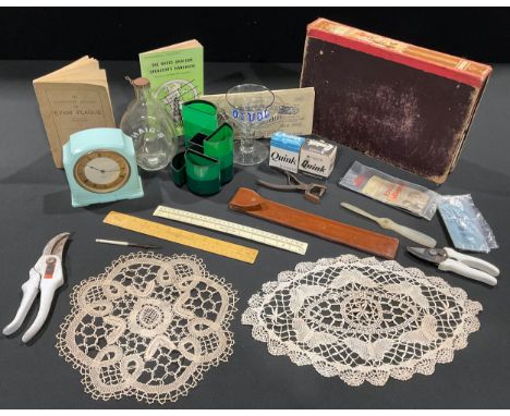
Lot 337
A clear glass rummer type goblet, RAF interest, commemorative of the Avro Lancaster, enamelled in blue, 15cm; a 1980s Italian Running Horse desk tidy; WWII blotting paper; a scale rule; a Smith's Bakelite electric mantel clock; a booklet about The Eyam Plague; a Radio operator's handbook; a Haig's bottle; etc
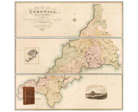
Lot 37
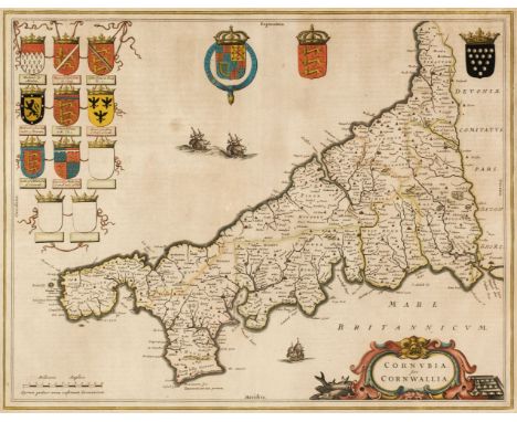
Cornwall. Greenwood (C. & J.), Map of the County of Cornwall from an Actual Survey, made in the Years 1826 & 1827, by C. & J. Greenwood. Most Respectfully Dedicated to the Nobility, Clergy & Gentry of the County, published Greenwood & Co. 1827, large scale engraved map on three sheets, sectionalised and laid on linen, bright contemporary wash colouring, inset map of the Scilly Isles, calligraphic cartouche, engraved vignette of St. Michaels Mount, table of explanation and compass rose, faint offsetting, each sheet approximately 605 x 1845 mm, each sheet edged in green silk, marbled endpapers, contained in a contemporary tree calf book box with a contrasting red morocco gilt label to the spineQTY: (1)NOTE:R. C. E. Quixley (2nd edition expanded by J. M. E. Quixley). Antique Maps of Cornwall and the Isles of Scilly, number 76. A fine copy in very good condition.
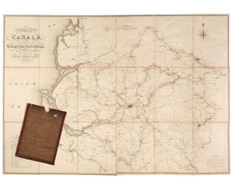
Lot 77
Johnson (William and Son). A Map of Several Canals situated in the Counties of Lancaster, Derby, York & Chester; Shewing the Heights of their pools above the Level of the Sea at Low Water...., 1825, map with contemporary outline colouring, engraved by J. & G. J. Pickett, sectionalised and laid on linen, calligraphic title, compass rose, mileage scale and table of reference, slight ink staining, 865 x 1240 mm, marbled endpapers, contained in a contemporary marbled card slipcase, case worn and rubbedQTY: (1)
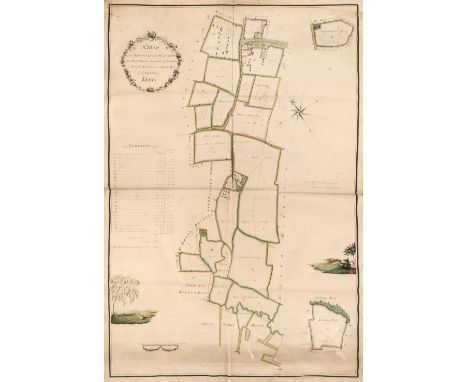
Lot 53
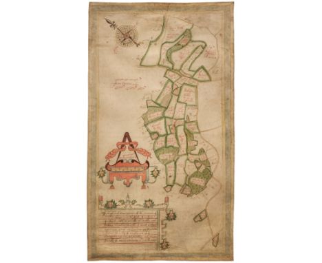
Estate Plan. Sparrow (Joseph), A Map of an Estate belonging to Mr. J. Dunk, also Stock Farm situated in the Parishes of Smeeth, Brabourn & Aldington in the County of Kent, 1803, pen, ink and watercolour plan on vellum, floriate cartouche, compass rose, contents list and scale of rods and chains, two inset maps of adjacent fields, two watercolour vignettes, one of a pastoral scene with cattle and sheep, the other of a running hare, old folds, some dust soiling, faint later pencil annotations, 910 x 630 mmQTY: (1)
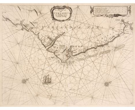
Lot 70
Ireland. Lootsman (Jacob), De Zuyd Oost Zyde van Yerlandt van Dubling tot aen t'Eylandt Corkbeg, circa 1668, uncoloured engraved chart of the southeast coast of Ireland from Dublin to Cork, ornamental strapwork title and distance scale, numerous rhumb lines, compass rose and ships, one closed tear professionally repaired at the base of the central fold, 415 x 545 mmQTY: (1)
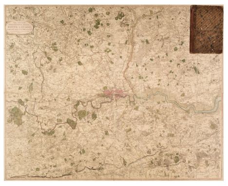
Lot 87
London. Faden (William), The Country Twenty-Five Miles Round London Planned from a Scale of One Mile to an Inch..., 3rd. edition, 1815, engraved map with contemporary outline colouring, sectionalised and laid on linen, 1015 x 1270 mm, contained in a contemporary half sheep book box, heavily worn and frayed, small area of loss to the foredge of the book boxQTY: (1)NOTE:James Howgego. The Printed Maps of London, number 188, state 7.
Lot 101
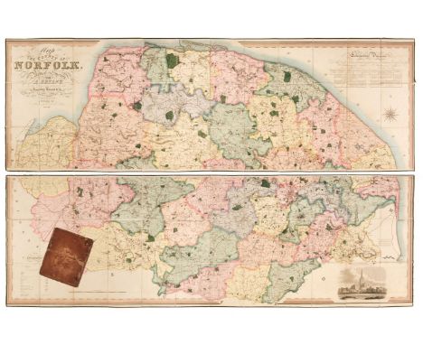
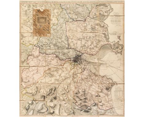
Norfolk. Bryant (Andrew), Map of the County of Norfolk from Actual Survey by A. Bryant in the Years 1824, 1825 and 1826, Respectfully dedicated to the Nobility, Clergy & Gentry of the County, published A. Bryant, Dec. 1st. 1826, large-scale engraved folding map on two sheets, bright contemporary hand colouring, sectionalised and laid on linen, calligraphic cartouche, list of the ecclesiastical divisions, compass rose, table of explanation and uncoloured engraved vignette of Norwich Cathedral, slight offsetting, bordered with green silk, each sheet approximately 750 x 2275 mm, contained in a contemporary sheep book box, box heavily worn and frayed with one section near detachedQTY: (1)NOTE:T. Chubb. A Descriptive List of the Printed Maps of Norfolk 1574 - 1916, page 106.
Lot 2
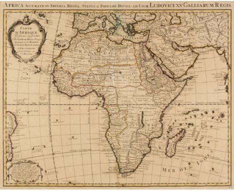
Africa. Covens (J. & Mortier P.), Carte D'Afrique Dressée pour l'Usage du Roy, par Guillaume DeLisle..., Amsterdam, circa 1730, engraved map with contemporary outline colouring, strap work cartouche and advertisement, title repeated in Latin in the upper margin, 510 x 635 mm, together with DeLisle (Guillaume). Carte D'Afrique Dressée pour l'usgae du Roy, par Guillaume DeLisle.., published by Phillipe Buache, Paris, circa 1745, engraved map with contemporary outline colouring, strap work cartouche and advertisement (a slightly later impression of the Covens & Mortier map), 505 x 650 mm, with Blaeu (Willem Janszoon), Aethiopia Inferior vel Exterior..., circa 1645, engraved map of South Africa with contemporary outline colouring, large decorative cartouche and mileage scale, large margins, 385 x 505 mm, no text on verso, plus Ortelius (Abraham). Barbariae et Biledulgerid Nova Descriptio, [1580], uncoloured engraved map, 330 x 500 mm, German text on verso, with another copy similar (1572 edition) with French text on the verso, with another four maps of Africa and South Africa including examples by or after Rapin/Tallis, le Rouge, Tardieu and Fullarton, and De Bruyn (Cornelius). Tyrus [1698 - 1714], uncoloured engraved panorama, taken from the sea, old folds, small near-contemporary manuscript notation in the upper margin, 250 x 640 mm and Scherer (Heinrich). Aethiopum Abassinorum Mores et Consuetudines, Munich [1702 - 10], uncoloured engraved decorative title page, 245 x 195 mmQTY: (11)
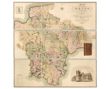
Lot 40
Devon. Greenwood (C. & J.), Map of the County of Devon from an Actual Survey, made in the Years 1825 & 1826 by C. & J. Greenwood, most Respectfully dedicated to the Nobility, Clergy and Gentry of the County, by the Proprietors Greenwood, Pringle and Co., February 20th, 1827, large scale engraved map on three sheets, sectionalised and laid on linen with bright contemporary wash colouring, inset map of Lundy Island, calligraphic cartouche, compass rose, table of explanation, uncoloured engraved vignette of the 'North West View of Exeter Cathedral', slight offsetting and spotting, each sheet edged in green silk, each sheet approximately 645 x 1905 mm, contained in a contemporary tree calf book box with a contrasting red morocco gilt label to spineQTY: (1)NOTE:Batten & Bennett. The Printed Maps of Devon, number 96.
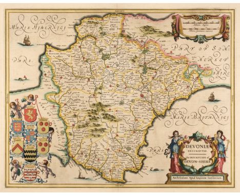
Lot 41
Devon. Jansson (Jan), Devoniae Descriptio. The Description of Devon-Shire, Amsterdam, circa 1646, engraved map with bright contemporary outline colouring, large decorative cartouche and mileage scale, large margins, slight spotting, 385 x 495 mm, French text on versoQTY: (1)NOTE:Batten & Bennett, The Printed Maps of Devon, number 11.
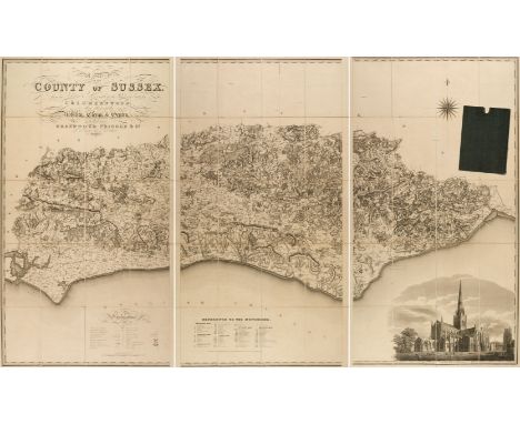
Lot 115
Sussex. Greenwood (C. & J.), Map of the County of Sussex from an actual Survey made in the Years 1823 & 1824..., Greenwood Pringle & Co., March 24th, 1825, large scale uncoloured engraved map, sectionalised and laid on linen, in three sections, calligraphic title, engraved vignette of Chichester Cathedral and table of reference to the hundreds, slight staining, 1250 x 2020 mm, marbled endpapers, contained in contemporary cloth slipcaseQTY: (1)
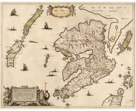
Lot 75
* Isle of Mull. Blaeu (W. J & Pont T.), Mula Insula quae es Aebudarum numero una est et Lochabriae ad occasum praetenditur. The Yle of Mull which is one of the Western Yles and lyeth ovir against Lochabÿr, Amsterdam, circa 1654, engraved map with contemporary outline colouring heightened in gilt, decorative title cartouche and mileage scale, 425 x 540 mm, mounted, framed and double-glazed, Latin text on verso QTY: (1)
Lot 73
Ireland. Taylor (John), Taylor's Map of the Environs of Dublin, extending 10 to 14 Miles from the Castle, by Actual Survey on a Scale of 2 Inches to 1 Mile, Dublin, 1816, engraved map with contemporary wash colouring, sectionalised and laid on linen, table of explanation, dedication and a note of the banks in Dublin Bay, 900 x 805 mm, contained in a contemporary marbled card slipcase, case worn and frayedQTY: (1)
![British Isles. Ortelius (Abraham), Angliae, Scotiae et Hiberniae sive Britannicar: Insularum Descriptio [1610 - 12], engraved](https://cdn.globalauctionplatform.com/910db78b-cd1e-4760-a5d0-b0dc011def41/93275106-35f3-4e1c-bceb-b11e011ddb36/468x382.jpg)
Lot 30
British Isles. Ortelius (Abraham), Angliae, Scotiae et Hiberniae sive Britannicar: Insularum Descriptio [1610 - 12], engraved map with contemporary hand colouring and some later enhancement, orientated to the east, large strapwork cartouche and a panel of descriptive text, occasional repaired marginal closed tears, some oxidisation causing cracking and splitting, repaired on verso, the whole backed with archival tissue, 345 x 500 mm, Italian text on verso, together with Ortelius (Abraham & Lhuyd Humphrey). Angliae Regni florentissimi nova descriptio auctore Humfredo Lhuyd Denbygiense, [1580], hand-coloured engraved map, large strapwork cartouche and mileage scale, some cracking and splitting affecting the printed surface, repaired on verso, 375 x 470 mm, German text on versoQTY: (2)NOTE:The first described item: Marcel van den Broecke, Ortelius Atlas Maps, number 16. R. W. Shirley, Early Printed Maps of the British Isles 1477 - 1650, number 86.The second item: Marcel Van den Broecke, Ortelius Atlas Maps no.19. State 1 with the uncorrected mileage scale. R.W.Tooley, Early Printed Maps of the British Isles 1477 - 1650, number 109.
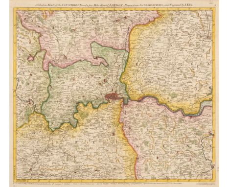
Lot 50
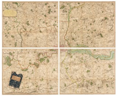
Environs of London. Faden (William), The Country Twenty-Five Miles Round London planned from a scale of one mile to an Inch, 3rd edition, 1802, engraved map on four sheets, contemporary outline colouring, sectionalised and laid on linen, each sheet approximately 515 x 620 mm, printed publisher's labels to the verso of each sheet, contained within a waxed card chemise and a contemporary blue card slipcase with printed label to the upper cover, slipcase worn and frayed, together with Mogg (Edward). Mogg's Twenty-Four Miles round London, 1812, circular engraved map with contemporary wash colouring, sectionalised and laid on linen, some staining and offsetting, small holes where old folds cross, 610 x 555 mm, some later pencil and ink annotations to the verso, contained in a contemporary card slipcase with orange and black publisher's label to the upper cover, slipcase heavily worn and frayed, with Andrews (John & Dury Andrew). A New Travelling Map of the Country round London, Extending from North to South 190 Miles and East to West 150 Miles..., September 30th, 1776, large scale engraved map with contemporary outline colouring, slight dust soiling, split and separated along an old fold, crude tape repairs to verso, 1010 x 1250 mm, contained in a modern marbled card slipcase with old publisher's label to the upper cover, plus another four later folding maps of the environs of London, including examples by or after Gall & Inglis and G. W. Bacon, various sizes and condition QTY: (7)NOTE:The first item described. J. Howgego, The Printed Maps of London, number 188, state 6.
Lot 84
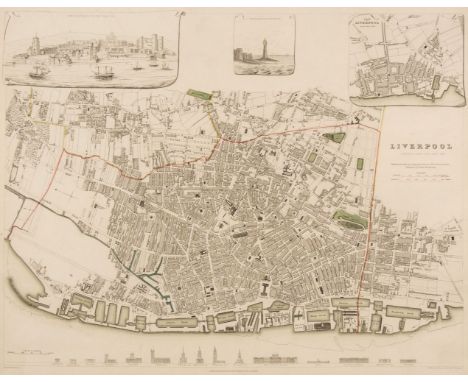
Liverpool. Starling (T.). Liverpool, published under the Superintendence of the Society for the Diffusion of Useful Knowledge, circa 1830, engraved map with contemporary outline colouring, 310 x 385 mm, together with Davies (B. R.), Liverpool and its Environs including the Cheshire Coast, circa 1830, engraved map after a survey by H. Austen, contemporary outline colouring, sectionalised and laid on linen, slight staining, some surface abrasion with loss, 445 x 530 mm, bound in contemporary cloth boards with gilt title to the upper cover, re-backed, size of boards 100 x 150 mm, with Philip (George & Son). Philips' Plan of the Town & Port of Liverpool with Birkenhead and the adjoining Cheshire Coast, circa 1860, engraved map with contemporary outline colouring, sectionalised and laid on linen, some later ink annotations, slight toning and dust soiling, 625 x 715 mm, bound in contemporary cloth boards with gilt title to the upper cover, size of boards 170 x 135 mm, plus Ordnance Survey (publishers). Untitled map of Liverpool and its environs, on a scale of six inches to a mile, 22nd September 1851, uncoloured engraved map, sectionalised and laid on linen, slight staining, 620 x 930 mm, contemporary cloth boards, upper board detached, spine crudely repaired, size of boards 225 x 145 mmQTY: (4)
Lot 52
Estate Plan. Boycot (Thomas). A mapp and Description of the mannor of hampton Liinge in the parish of braborne In Kent: with: 31: parcells of arrable and Pasture:; and: 12: Parcells of wood containing: 320: acrers noc Quarters:: 38: Peartches The: 31 Parcells of arrable and Pasture Contayne: 253: - 2 - 36: pertches: and the: 12 Parcells of wood Containe: 66 - 2 - D perchs, 1650, pen, ink and watercolour plan on vellum, compass rose, decorative distance scale surmounted by dividers, some dust soiling and creasing, 690 x 390 mmQTY: (1)NOTE:An unusually well-preserved mid-17th-century estate plan in the vicinity of Braborune, south-east Kent.This lot is subject to the Manorial Documents Rules 1959, 1963 and 1967, administered by The Historical Manuscripts Commission at The National Archives on behalf of the Master of the Rolls. Accordingly the purchasers of the documents lie under an obligation to notify the Secretary of the Commission of their acquisition and to provide details of where they will be kept. They may in no circumstances be removed from England and Wales without the prior consent of the Master of the Rolls.
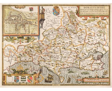
Lot 43
Dorset. Speed (John), Dorsetshyre with the Shyre-towne Dorchester described, as also the Armes of such noble families as have bene honored with the Titles there of since the Normans Conquest to this present, 1st edition, [1611], hand coloured engraved map, inset town plan of Dorchester, large strapwork cartouche and mileage scale, good margins, central fold strengthened on verso, unobtrusive blind stamp to the upper right corner, 385 x 510 mm, English text on versoQTY: (1)
Lot 49
Environs of London. A collection of ten maps, 18th and 19th century, engraved and lithographic maps of the environs of London, including examples by or after Bowen, Ellis, Cole, Kitchin, Moll, Stanford, Downes, Russell and Phillips, various sizes and condition, mounted, together with Faden (William). An Untitled large scale map Sheet primarily of Essex (From Faden's four-sheet map of the Environs of London), 1787, engraved map with contemporary outline colouring, slight oxidisation to old watercolour, 525 x 630 mm, mountedQTY: (11)
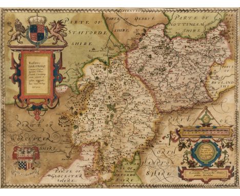
Lot 127
Warwickshire and Leicestershire. Saxton (Christopher), Warwic Lecestriaeq. Comita Civitat. Oppidoru. Villaru. Fluminu. Ceterarumq. Rerum omnium in eisdem memorabilium, nova, veraq. descriptio, [1579], engraved map by Leonard Terwoort, contemporary hand colouring with some later enhancement, elaborate strapwork cartouche and mileage scale, the latter surmounted by dividers, coat-of-arms of Elizabeth I with the addition of the heraldic crest of Thomas Seckford, some oxidization causing small areas of cracking and splitting and slight loss, trimmed to decorative margin and laid on later card, slight staining, 390 x 520 mm, framed and glazedQTY: (1)NOTE:The first printed map of Warwickshire and Leicestershire from the earliest national atlas of England and Wales.
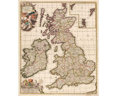
Lot 27
British Isles. De Wit (Frederick), Novissima prae caeteris aliis accuratissima Regnorum Angliae Scotiae Hiberniae..., Amsterdam circa 1690, engraved map with contemporary outline colouring, inset map of the Orkney, Faroes and Shetland Islands, decorative cartouche and mileage scale, slight oxidisation to old watercolour causing small cracks and splits, repaired on verso, occasional marginal closed tears, 590 x 500 mmQTY: (1)NOTE:R. W. Shirley. Printed Maps of the British Isles, 1650 - 1750. De Wit 6, state 2.
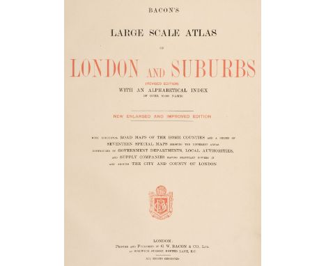
Lot 279
Bacon (G. W. publisher). Bacon's Large Scale Atlas of London and Suburb (revised Edition) with an Alphabetical Index..., circa 1920s, title and contents list, contents page with long closed repaired tear, 7 lithographic double-page county maps, 20 maps of London, index map and 35 sheet map of London, publisher's half morocco, worn and bumped, folio, together with Bacon's Popular Atlas of the British Isles..., 1907, additional half-title, preface and contents, 72 double-page colour lithographic maps and diagrams and charts, upper hinge weak, publisher's decorative gilt cloth, a little frayed along the spine, folio, with Bacon's General Atlas of the World with Index, circa 1930, title and contents, frontispiece of national flags and 49 double-page colour lithographic maps, index bound at rear, manuscript presentation inscription to first front blank, hinges weak, contemporary half morocco gilt, worn and rubbed at extremities, folioQTY: (3)
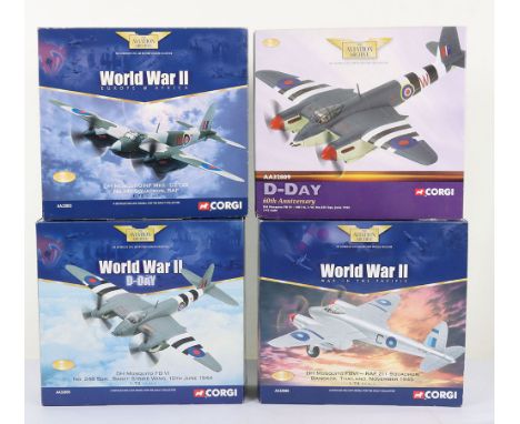
Lot 203
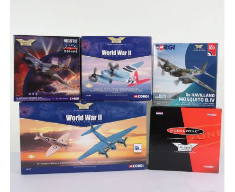
Four Corgi Aviation Archive DH Mosquito Aircraft 1:72nd Scale Models, AA32803 DH Mosquito NF MkII DZ726 No.141 Sqd RAF, AA32805 DH Mosquito FB VI No.248Sqn, Banff Strike Wing, 10th June 1944, AA32806 DH Mosquito FBVI RAF 211 Sqn, Bangkok Thailand and AA32809 DH Mosquito FB VI- HR118, 3-W, all the models are in mint not displayed condition, boxes are good to excellent with some age wear.(4 items)
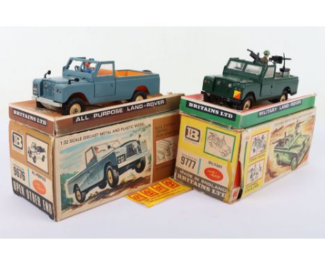
Lot 450
Two Britains 1:32 scale Land Rovers, 9777 Military Land Rover, green with figures, guns, radio and shovel, good condition, two chips to front bumper and lacks pickaxe, box fair, some wear and tear, 9676 all-purpose Land Rover, grey with orange interior and driver, good condition some wear and chip to front bumpers, box with stickers, fair, creases and some tears, lacks pull off end, (2 items).
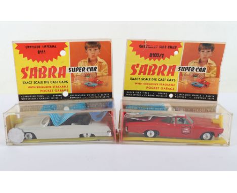
Lot 483
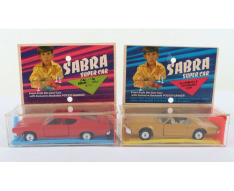
Two Boxed Sabra (Israel) 1/43 scale USA Super Cars, 8103/1 Chevrolet Fire Chief red/white body, white interior, spun wheels, with collect Israeli coins club leaflet and coin and 8111 Chrysler Imperial white body, black interior, spun wheel hubs, with collect Israeli coins club leaflet and coin both near mint to mint original condition, with perspex stackable pocket garages, with header cards, some slight staining to rear of header card 8111. (2 items)
Lot 24
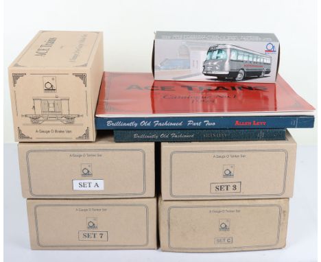
ACE Trains 0 gauge four 4-wheel Tanker sets, set 3 three Pratts tankers, set 7 with Esso, Power Ethyl and BP Motor Spirit tankers, set A three United Dairy tankers, G4/1L 3 rail brake van with lighting, all in near mint condition, boxes all with inner packing and paperwork, together with a set 7 tanker set in a Set C box, tankers in near mint condition, box lid with water damage, together with a ACE 1:43 scale tinplate single decker 1959 Bussing Autobus prototype, hardback Brilliantly Old Fashioned, The Story of ACE 0 gauge trains by Allen Levy, signed copy of ACE Trains, The Publicity & Listings, 1995-2010 by Allen Levy and a No.1 catalogue 1998, (9 items).
Lot 490
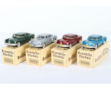
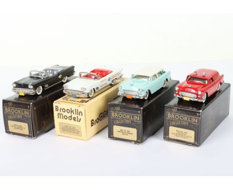
Four Brooklin Models 1/43 scale, BRK 2X 1948 Tucker Limited Edition Movie Souvenir turquoise, BRK 2X 1948 Tucker Limited Edition Movie Souvenir red, BRK 2X 1948 Tucker Limited Edition Movie Souvenir silver, BRK 2x 1948 Tucker Torpedo tucker Automobile Club of America Convention. June 26th-28th 1992 green, all mint boxed condition, models wrapped in original packing, boxes with inner packing, one box with tape to end flap tabs, (4 items).
Lot 204
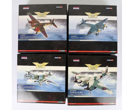
Four Corgi Aviation Archive DH Mosquito Aircraft 1:72nd Scale Models, AA32814 DH Mosquito PR.I W4051, LY-U. No.1 PRU Huly 1941, AA32816 DH Mosquito B XX, No.627 Squadron RAF, Woodhall Spa Sept 1944, Wing Commander Guy Gibson, AA32817 De Havilland Mosquito Prototype W4050 based at the de Havilland heritage centre and AA32818 DH Mosquito FB VI-HR405 143 sqn, RAF Banff Wing Feb 1945, all the models are in mint not displayed condition, boxes excellent. (4 items)
Lot 525
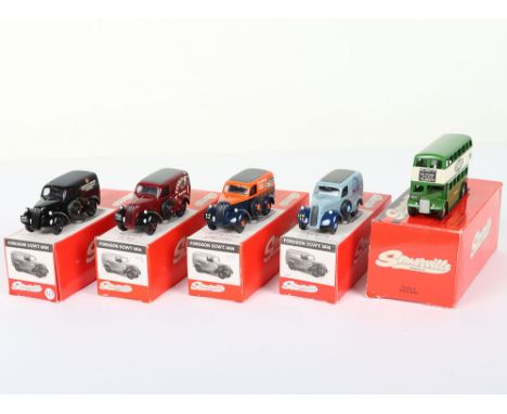
Four Somerville Models 1/43 scale Fordson 5CWT delivery vans and a Double Decker bus, 113 Lewis East Ltd, 114 Butcher Demonstrator, 115 Colchester Tractors, 116 London Toy Museum and a Billingmay Double Decker bus reproduction of a 1946 Dinky toy, all mint boxed condition, models wrapped in original packing, (5 items).
Lot 617
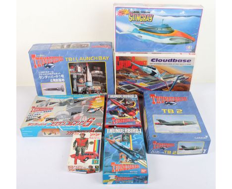
Thunderbirds Japanese Plastic Kits, Aoshima 1/350 scale TB1 Launch Bay, TB2, Bandai Thunderbird 1, Thunderbird 3 both still sealed, plus Imai Captain Scarlet, Imai Cloudbase, Lee Automatic Stingray all in mint un-made condition, plus a Bandai Thunderbirds Are Go diecast model set of six.(8 items)
Lot 207
Five Corgi Aviation Archive DH Mosquito Aircraft 1:72nd Scale Models, AA32807 DH Mosquito PR.XVI USAAF 325 Photographic Wing RAF Watton Norfolk 1944, AA32815 DH Mosquito FBVI 515 Sqn Little Snoring April 1945, AA32821 DH Mosquito FB.VI Moonbeam, DH Mosquito Royal Air Force Centenary Collection No.12 and AA99110 DH Mosquito PR Mk IV & Supermarine Spitfire No1 Photo Recon unit, all the models are in mint not displayed condition, boxes excellent. (5 items)
Lot 518
Lot no 518: Four Brooklin Models 1/43 scale model, BRK 25 1958 Pontiac Bonnevelle Convertible black, BRK 25X 1958 Pontiac Bonnevelle Indianapolis Pace car Special Edition 1989 white, BRK 26 1955 Chevrolet Nomad estate turquoise, BRK 26A Chevrolet Fire Marshal’s Truck ‘Rock Country’ red, all mint boxed condition, models wrapped in original packing, boxes with inner packing, 26A box both end flap tabs taped, (4 items). Est: £80-120 (plus 26.4% BP*) 70 21-30
Lot 481
Two Boxed Sabra (Israel) 1/43 scale USA Super Cars, 8109 Oldsmobile Tornado, mustard body, white interior, spun wheel hubs and 8121 Ford Torino red body, red interior, spun wheels, in 8123 box, both near mint to mint original condition, with perspex stackable pocket garages, with header cards, both boxes have a small crack. (2 items)
Lot 519
Lot no 519: Four Brooklin Models 1/43 scale model, BRK 27 1957 Cadillac Eldorado Brougham silver, 27X 1957 Cadillac Eldorado P.C.T.S 1992 black, BRK 28 1957 Mercury Turnpike Cruiser brown, BRK 29 1953 Keiser Manhattan four door Sedan blue, all mint boxed condition, models wrapped in original packing, boxes with inner packing, BRK29 box damage to one end, (4 items). Est: £80-120 (plus 26.4% BP*) 70 21-31

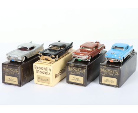
Lot 506
Lot no 506: Four Brooklin Models 1/43 scale model, BRK 27 1957 Cadillac Eldorado Brougham silver, 27X 1957 Cadillac Eldorado P.C.T.S 1992 black, BRK 28 1957 Mercury Turnpike Cruiser brown, BRK 29 1953 Keiser Manhattan four door Sedan blue, all mint boxed condition, models wrapped in original packing, boxes with inner packing, (4 items). Est: £80-120 (plus 26.4% BP*) 70 21-18


Lot 516
Lot no 516: Four Brooklin Models 1/43 scale model, BRK 14 1940 Cadillac V16 Convertible Coupe bronze, BRK 17 1952 Studebaker Champion Starlight Coupe black, BRK 18 1941 Packard Clipper maroon, BRK 20 1953 Buick Skylark Convertible metallic green, , BRK 20A 1953 Buick Skylark Convertible red, all mint boxed condition, models wrapped in original packing, boxes with inner packing, together with two The Brooklin Video by John Hammick and David Angel Vol 1 and a selection of spare tyres, (7 items). Est: £100-150 (plus 26.4% BP*) 70 21-28
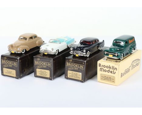
Lot 510
Lot no 510: Four Brooklin Models 1/43 scale model, BRK 38 1939 Graham Combination Coupe brown, BRK 39 1953 Oldsmobile Fiesta licensed by General Motors Corp white, BRK 40 1948 Cadillac Dynamic fast back Coupe licensed by General Motors Corp dark blue, BRK 42X Ford F1 panel Delivery Modelex ’92 October 10th & 11th 1992 metallic green, all mint boxed condition, models wrapped in original packing, boxes with inner packing, (4 items). Est: £80-120 (plus 26.4% BP*) 70 21-22
-
216134 item(s)/page