We found 216136 price guide item(s) matching your search
There are 216136 lots that match your search criteria. Subscribe now to get instant access to the full price guide service.
Click here to subscribe- List
- Grid
-
216136 item(s)/page


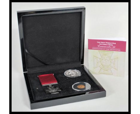
Lot 703
The First World War Victoria Cross Gold Half Sovereign Set - A Bradford Exchange two coin and medal coin set featuring a 1912 gold 22ct half sovereign 3.99g, 999 pure silver 1 oz crown and a 1:1 scale replica Military interest Victoria Cross. All contained within coin capsules in sleek fitted black case with certificate booklet.
Lot 3478
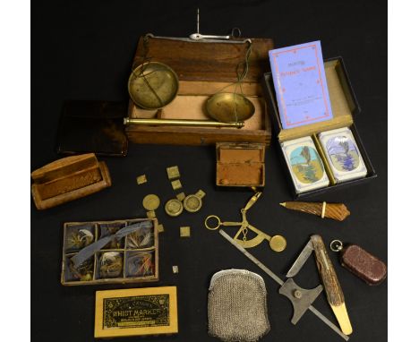
Medicine - an interesting collection of prepared microscope slides, comprehensively labelled and annotated, including ** muscle from a man who died in the London Hospital, Head of Blow Fly, and Scale of Jack Fish, many with labels for Prize Medal, Paris 1867, arranged in eight trays, the case with hinged cover and fall front, 21cm wide overall; others, Animal Hairs (2)
Lot 148
Australasia. A collection of sixteen maps of Australia, New Zealand and Oceania, late 19th century, mostly large scale maps of New Zealand, states of Australia, Figi and New Guinea, all printed by 'The Picturesque Atlas Publishing Company of Sydney & Melbourne', various sizes and condition (16)
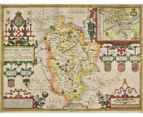
Lot 149
Bedfordshire. Speed (John), Bedford Shire and the situation of Bedford described with the armes of those honorable familyes that have borne ye titles of dukes and earls thereof, published George Humble, circa 1646, engraved map, inset town plan of Bedford, large strapwork cartouche and mileage scale, torn with slight loss to lower right vertical margin, replaced in facsimile, 385 x 510 mm, English text on verso (1)
Lot 156
British Isles. De L'Isle (Guillaume), Les Isles Britanniques ou sont le Rme. d'Angleterre tir‚ de Sped celut d'Ecosse tir‚ de Th. Pont &c. et celut d'Irlande tire de Petti. Le tout rectif‚ pas diverses observations, published J. A Dezauche, Paris, 1772, engraved map with contempoary hand colouring, decorative cartouche and mileage scale, slight creasing, 475 x 615 mm, together with Cassini (Giovani Maria), Le Isole Britanniche antiche..., 1799, engraved map with contemporary outline colouring, 375 x 505 mm, with Janvier (Jean), Les Isles Britanniques comprenant les Royaumes d'Angleterre, d'Ecosse et d'Irlande divis‚s en grandes provinces..., Paris, circa 1770, engraved map with contemporary hand colouring, small juvenile sketch on verso, 315 x 450 mm, plus Tardieu (Pierre Alexander), Isles Britanniques deuxieme carte Angleterre ancienne, Paris, circa 1750 engraved map with contemporary outline colouring, 330 x 430 mm (4)
Lot 160
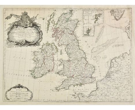
British Isles. Jaillot (Alexis Hubert), Les Isles Britannique qui contiennent les Royaumes d'Angleterre, Ecosse et Irlande distingu‚s enleurs principales provinces subdivis‚es en leurs Shireries ou comt‚s..., circa 1740, engraved map with contemporary hand colouring, inset map of the Faroe, Shetland and Orkney islands, large uncoloured decorative cartouche and mileage scale, 495 x 600 mm, together with Merian (Matthaus), Magnae Britanniae et Hiberniae Nova Descriptio, [1658], hand coloured engraved map, inset map of the Orkney islands, 320 x 390 mm (2)
Lot 166
British Isles. Janvier (Jean), Les Isles Britanniques Comprenant les Royaumes D'Angleterre, D'Ecosse et D'Irlande, Divis‚s en Grandes Provinces, Subdivis‚s par Comt‚s, Dress‚s sur les Observations Astronomiques, circa 1760, engraved map with contemporary outline colouring, large ornate black and white cartouche and mileage scale, inset map of the Shetland and Orkney islands, 475 x 650 mm (1)
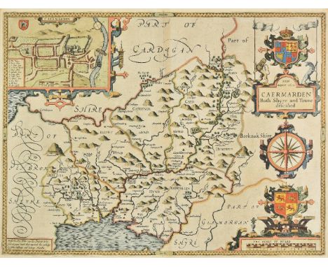
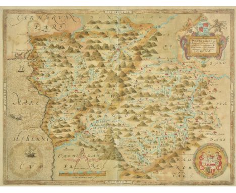
Lot 169
*Carmarthenshire. Speed (John), Caermarden both shyre and towne described, 1st. edition, published John Sudbury & George Humble, [1611], hand coloured engraved map, inset town plan of Carmarthen, large strapwork cartouche, compass rose and mileage scale, 385 x 510 mm, English text on verso, mounted, framed and double glazed (1)
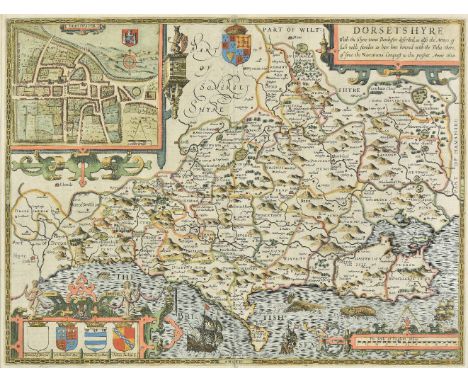
Lot 176
*Dorset. Speed (John), Dorsetshyre with the shyre-towne Dorchester described as also the armes of such noble families as have bene honored with the titles there of since the Normans conquest to this present, 1st edition, [1611], hand coloured engraved map, inset town plan of Dorchester, strapwork cartouche and mileage scale, 385 x 510 mm, mounted, framed and double glazed, English text on verso (1)
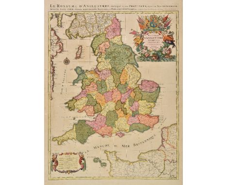
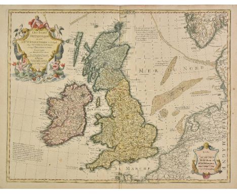
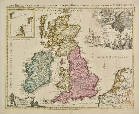
Lot 179
England & Wales. Jaillot (Alexis-Hubert & Sanson Nicolas), Le Royaume d'Angleterre distingu‚ en ses provinces..., Paris, [1693], large engraved map with contemporary hand colouring, large decorative cartouche and mileage scale, 780 x 585 mm, together with Les Isles Britanniques; qui contiennent les Royaumes d'Angleterre, Escosse, et Irlande, 1692, large engraved map with contemporary hand colouring, inset map of the Faroe, Shetland and Orkney islands, some browning and offsetting, some oxidisation to old watercolour which is strengthened on verso, 585 x 880 mm R. W. Shirley. Printed Maps of the British Isles 1650 - 1750, Jaillot 2, state 2. [and] Jaillot 1, Plate 2 state 1. (2)
Lot 185
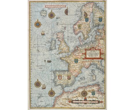
Europe. Waghenaer (Lucas Janszoon), Universe Europe Maritime Eiusque Navigationis Descriptio. Generale Paschaerte van Europa..., [1583 or slightly later], hand coloured sea chart, engraved by Joannes Doetecum, strapwork title cartouche and mileage scale, compass roses and numerous rhumb lines, slight loss to printed horizontal margins, professionally restored in facsimile, 560 x 395 mm, Latin text on verso Published in Wagheaer's "Spiegel der Zeevaerdt..."; the first printed sea atlas with charts and sailing directions assembled systematically in one book. Rockhall is marked on the map but its name is etched in upside down. The chart also shows the mythical island of Brazil to the south west of Ireland. Iceland is depicted as being almost circular, an error which is corrected in later editions of the chart. This map was significantly larger than the others in the atlas and as a result it often suffers damage to its margins. This copy has been very well restored. (1)
Lot 188
France. Ortelius (Abraham), Picardiae Belgicae regionis descriptio, [1602], hand coloured engraved map, large strapwork cartouche and mileage scale, 330 x 515 mm, Spanish text on verso, together with Andegavensium Ditionis Vera Et Integra Descriptio, [1602], uncoloured engraved map, large strapwork cartouche and mileage scale, 360 x 480 mm, Spanish text on verso, with Van der Aa (Pieter), Carte du Governemant de Guyenne et Gascogne..., circa 1710, uncoloured engraved map with a 'picture frame' border, trimmed to neatline along lower margin, 265 x 385 mm, plus Faden (William), France divided into provinces, 1790, engraved map with contemporary hand colouring, decorative uncoloured cartouche, 535 x 625 mm, with another seven country and regional maps of France, with examples by Vuillemin, Neele, Russell, Hewitt and J & C Walker, various sizes and condition (11)
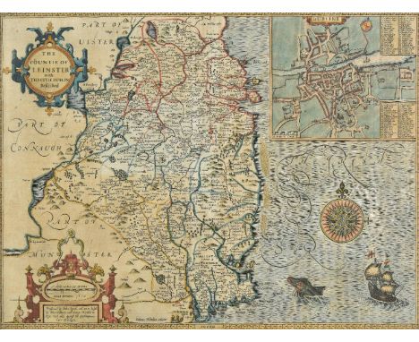
Lot 202
*Ireland. Speed (John), The Countie of Leinster with the citie Dublin described, published John Sudbury & George Humble, [1611 or later], hand coloured engraved map, inset town plan of Dublin, strapwork cartouche, mileage scale and compass rose, trimmed to strapwork margins, 375 x 495 mm, mounted, framed and glazed (1)
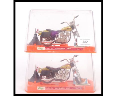
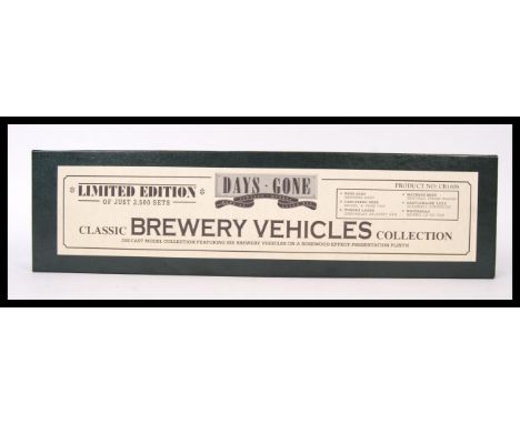
![*Lancashire. Saxton (Christopher & Hole G.), Lancastriae comitatus palatinus olim pars Brigantum, 1st edition, [1607], ha](https://cdn.globalauctionplatform.com/a3ebd08e-0d61-45d7-b5d0-a9f500c017ad/9f64529f-eb2e-4f65-a503-a9fc00e16b9f/468x382.jpg)
Lot 205
*Lancashire. Saxton (Christopher & Hole G.), Lancastriae comitatus palatinus olim pars Brigantum, 1st edition, [1607], hand coloured engraved map, large strapwork cartouche, mileage scale and compass rose, 300 x 310 mm, mounted, framed and glazed, together with Cestriae comitatus Romanis legionibus et coloniis olim insignis vera et absoluta descriptio, [1607 or later], hand coloured engraved map, 'open book' cartouche, 255 x 200 mm, mounted, framed and glazed, with Caernarvo comitatus pars olim Ordovicum, [1637], hand coloured engraved map, large strapwork cartouche and mileage scale, 250 x 310 mm, mounted, framed and glazed (3)
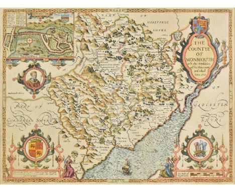
Lot 219
*Monmouthshire. Speed (John), The countye of Monmouth with the sittuation of the shire-towne described, 1st edition, published John Sudbury & George Humble, [1611], hand coloured engraved map, inset town plan of Monmouth, large strapwork cartouche and mileage scale, 385 x 510 mm, English text on verso, mounted, framed and double glazed (1)
Lot 220
*Montgomeryshire & Merioneth. Saxton (Christopher), Montgomeri ac Merionidh duorum borialis Cambriae comitatuum B. Gwinedhia A. North Wales nuneupar descriptio, [1579], engraved map with contemporary hand colouring, strapwork cartouche and mileage scale and the coat of arms of Thomas Seckford, slight offsetting, 345 x 455 mm, mounted, framed and glazed (1)
Lot 233
*Rutland. Speed (John), Rutlandshire with Oukham and Stanford her bordering neighbour newely described, published Thomas Bassett & Richard Chiswell [1676], hand coloured engraved map, inset town plans of Oakham and Stanford, large strapwork cartouche and mileage scale, 380 x 510 mm, framed and double glazed, English text on verso (1)
Lot 243
Wales. Blaeu (Johannes), Monumenthensis comitatus vernacule Monmouthshire, Amsterdam, circa 1645, engraved map with bright contemporary hand colouring, decorative cartouche and mileage scale, 380 x 495 mm, Dutch text on verso, together with Schenk (Pieter & Valk Gerard), Ceretica sive Cardiganensis comitatus Anglis Cardiganshire, [and] Mervinia et Montgomeria comitatus, circa 1700, two hand coloured reticulated engraved maps, each approximately 380 x 495 mm (3)

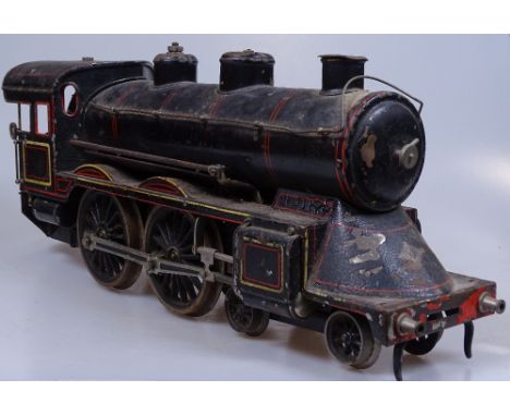
Lot 1
A rare large-scale Gauge 1 Live Steam-powered Tinplate 4-4-0 Steam Locomotive and Tender, early 20th century, probably Marklin or Bing, 45mm gauge, traces of original label on front, together with 2 Bing tinplate passenger and guard carriages of the same gauge, all in un-restored, untouched condition, locomotive length 16"

-
216136 item(s)/page