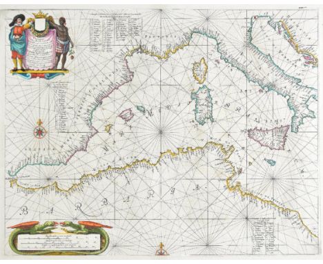
Mediterranean. Jansson (Jan), Pascaarte van 't Westelyckste deel vande Middelandsche Zee..., published Amsterdam, circa 1657, hand coloured engraved sea chart of the Western Mediterranean, decorative cartouche and mileage scale, compass rose and numerous rhumb lines, slight staining, two small professionally repaired closed tears to margins, 420 x 540 mm, Latin text on verso, mounted Originally published in Jansson's sea-atlas "De Water-Weereld." (1)
We found 216136 price guide item(s) matching your search
There are 216136 lots that match your search criteria. Subscribe now to get instant access to the full price guide service.
Click here to subscribe- List
- Grid
-
216136 item(s)/page
Yorkshire. Hobson (William Colling), This Map of Yorkshire is most respectfully dedicated to the nobility, clergy, gentry, landowners and manufacturers of the county, 1843, large scale uncoloured engraved map on four sheets, engraved by J & C Walker, some repaired marginal closed tears, slight staining, each sheet approximately 630 x 790 mm, bound in contemporary blue paper wrappers with printed label to upper cover 'Part Third. Greenwood and Compys. Atlas of England and Wales' (1)
Sale Item: SET SCALE WITH BRASS PANS & ASSORTED WEIGHTS (AF) Vat Status: No Vat Buyers Premium: This lot is subject to a Buyers Premium of 15% + Vat @ 20% Additional Info : Lots purchased online with the-saleroom.com will attract an additional charge for this service in the sum of 3% of the hammer price plus VAT @ 20%

-
216136 item(s)/page