We found 216134 price guide item(s) matching your search
There are 216134 lots that match your search criteria. Subscribe now to get instant access to the full price guide service.
Click here to subscribe- List
- Grid
-
216134 item(s)/page

![Herefordshire. Saxton (Christopher), Frugiferi ac Ameni Herefordiae comitatus delineatio, [1579], engraved map by Remigius Ho](https://cdn.globalauctionplatform.com/fa12dfe7-480b-47cc-946e-a815010dd53d/db1ac0b1-77e9-404c-ca6b-59ab4a7eeda8/468x382.jpg)
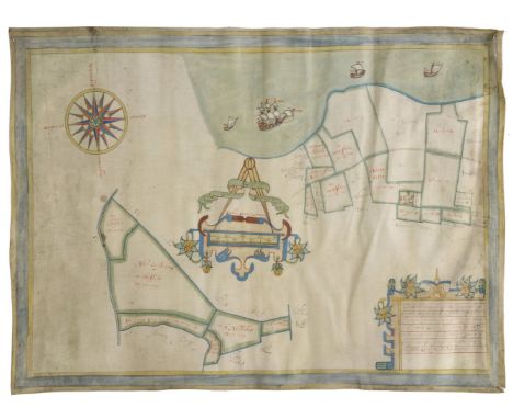
Lot 192
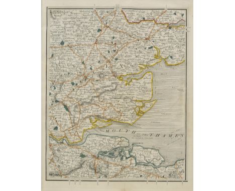
Herefordshire. Saxton (Christopher), Frugiferi ac Ameni Herefordiae comitatus delineatio, [1579], engraved map by Remigius Hogenberg, contemporary hand colouring, elaborate cartouche and with the arms of Thomas Seckford, dividers and mileage scale, central fold strengthened on verso, one repaired closed tear affecting image, some dust soiling largely confined to margins, 370 x 500 mm This copy has the 'bunch of grapes' watermark, widely considered to be indicative of one of the earliest states of Saxton's maps. (1)
Lot 194
Huntingdonshire. Gordon (William), An Accurate Map of the County of Huntingdon actually survey'd after a new method in the years 1730 & 1731, [1731], engraved hand coloured map, engraved by Emanuel Bowen, one sheet only from Gordon's large scale map of Huntingdonshire, central fold with some cracking and splitting, professionally repaired on verso, 500 x 600 mm, together with another twenty maps of Huntingdonshire, including examples by Smith, Cary, Seller, Badeslade & Toms, Phillips, Morden, Owen & Bowen, Moll, Moule, Rocque, Bowen, Kitchin and Pigot/Slater, some duplicates, various sizes and condition, together with Bleau (Johannes), Comitatus Northantonensis vernacule Northamptonshire, published Amsterdam, circa 1648, engraved map with contemporary hand colouring, 420 x 500 mm, French text on verso, with Saxton (Christopher & Kip William), Suffolciae comitatus cuius populi..., [1637], uncoloured engraved map, old folds, laid on later paper, 280 x 385 mm, plus Morden (Robert), Lincolnshire, circa 1705, uncoloured engraved map, old fold, 225 x 175 mm (24)
Lot 196
Isle of Thanet. Boycot (Gulielmus) Untitled estate plan, circa 1650, pencil and watercolour on vellum, large mileage scale topped by dividers, large compass rose, some dust soiling and slight creasing, 440 x 595 mm The surveyor's note in the lower right corner reads :- The description of one meassuage called Streete farme with 14 pcells of Arable thereunto belonginge lyinge in the parishes of S. Johns & minister in the Ile of Thannett conte. 107 - 0 - 26 more 6 pcells of fresh marsh lyinge in the parishes of Chisslett & S Nicholas conty 91 - 1 - 27. (1)
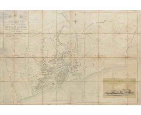
Lot 197
Kingston Upon Hull. Wilkinson (George), This trigonometrical plan of the Town, Port and Harbour of Kingston upon Hull including the environs of Sculcoates, North and South Myton, Drypool &c. &c. from actual survey..., published Goddard and Lancaster, September, 1848, large lithographic map with contemporary outline colouring, sectionalised and laid on linen, manuscript presentation inscription to Mr. Huffam from Mr. Goddard, vignette of 'The New Passenger Station' some mould and waterstaining, 955 x 1410 mm, contained in a modern red cloth slipcase with morocco gilt label to spine A scarce and large scale plan of Hull. (1)
Lot 20
Johnston (Alexander Keith). The Royal Atlas of Modern Geography, new edition, published W. & A. K. Johnston, 1878, additional half title, dedication and preface, numerous engraved maps with contemporary outline colouring, endpapers and preliminaries, torn and frayed, slight dust soiling, hinges and joints weak, all edges gilt, contemporary half morocco gilt, worn and frayed, folio, together with Handy Royal Atlas of Modern Geography, 1889, title, dedication and preface, numerous engraved maps with contemporary outline colouring, all edges gilt, publisher's half morocco gilt, sidings stained, folio, with another copy similar, with, Bacon (G. W., editor), New large-scale atlas of the British Isles from the Ordnance Survey, 1892, title and preface, numerous double page colour lithographic county, regional and town plan maps, all edges gilt, publisher's half morocco gilt, worn and frayed, folio, plus Bartholomew (J. G.), The Royal Atlas of England and Wales, published George Newnes Limited, circa 1900, numerous colour lithographic maps, front endpaper detached, publisher's half morocco gilt, worn and frayed, folio, and Bevan (G. Philips), Royal Relief Atlas of all parts of the World, 3rd edition, published George Philip & Son, 1885, thirty-one (complete as list) colour printed maps, including twenty-five relief maps with raised surface to indicate mountains or hills, all with accompanying text on verso, each presented on a thick card frame, map of New Zealand with long closed tear affecting image, hinges and joints weak, publisher's half morocco gilt, spine chipped with loss at head and foot, worn, 4to, with another seven atlases similar, mixed bindings, mostly 4to and folio Sold as a collection of maps, not subject to return. (13)
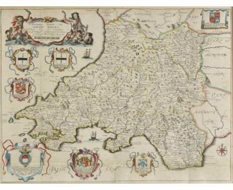
Lot 230
*South Wales. Blome (Richard), A Generall Mapp of South Wales..., circa 1673, hand coloured engraved map, old folds, 350 x 465 mm, mounted, framed and glazed, together with, Saxton (Christopher & Hole William), Monumethensis comitatus quem olim incoluerunt silures, circa 1610, hand coloured engraved map, large strapwork cartouche, mileage scale and compass rose, 275 x 345 mm, mounted, framed and glazed (2)
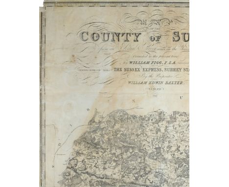
Lot 236
Sussex. Figg (William), Map of the County of Sussex from an Actual Survey made in the Years 1823 & 1824, Corrected to the present time by William Figg F.S.A. Surveyor, Presented to the Subscribers to The Sussex Express, Surrey Standard & Kent Mail by the Proprietor William Edwin Baxter, 1861, uncoloured engraved large scale map on eight sheets, table of explanation, reference to the hundreds and an uncoloured vignette of Chichester Cathedral, some fraying, toning and creasing to map sheets, each sheet laid on modern paper and bound in 20th century cloth a little worn at extremities, folio (1)
Lot 243
Yorkshire. Rocque (John), The West Riding of Yorkshire, The North Riding of Yorkshire [and] The East Riding of Yorkshire, [1746], together three uncoloured engraved maps, old folds, each approximately 160 x 200 mm, together with Hutchinson (Thomas & Osborne Thomas), A Map of the West Riding of Yorkshire [and] A Map of the East Riding of Yorkshire, [1745], two hand coloured engraved maps, each approximately 150 x 175 mm, the East Riding mounted, with Van den Keere (Pieter), Eboracensis comitatus, circa 1617 [and] Yorkshire, circa 1627, the first an uncoloured engraved map, slight overall toning, the second hand coloured, old folds strengthened on verso with slight loss to upper left corner, both approximately 120 x 170 mm, plus Van Langren (Arnold), Yorkeshire, [1643], uncoloured engraved map with triangular mileage scale, one juvenile crayon line to image, old folds, 200 x 195 mm, with two other maps similar including examples by Cowley and Mercator/Keere, various sizes and condition (10)
Lot 55
Cary (John). Cary's New Map of England and Wales with Part of Scotland..., Second Edition, Corrected to 1835, published May 1st 1832 [but slightly later], engraved title, dedication, explanations, scale of distance and hand-coloured general map, 76 hand-coloured maps (numbered 1 to 81, omitting 62/63, 71/2 & 80 as intended, being featureless parts of the 'German ocean'), a few minor marginal splits, vertical crease, contemporary limp morocco sidings, bound 'envelope style' with gilt fastener, heavily rubbed and slightly scuffed, 4to (unfolded) (1)
Lot 204
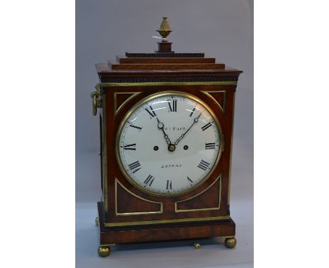
A GEORGE III THOMAS PACE OF LONDON MAHOGANY CASED EIGHT DAY BRACKET CLOCK, gilt metal pineapple finial above stepped rectangular pediment, painted circular convex 19cm (7 3/4'') dial with Roman numerals, the twin fusee movement unsigned, gilt metal rosette back plates and ring handles above brass fish scale cut and red fabric sound frets, on four gilt ball feet, case with alterations, height approximately 47.5cm, with winding key, case keys and pendulum
Lot 591
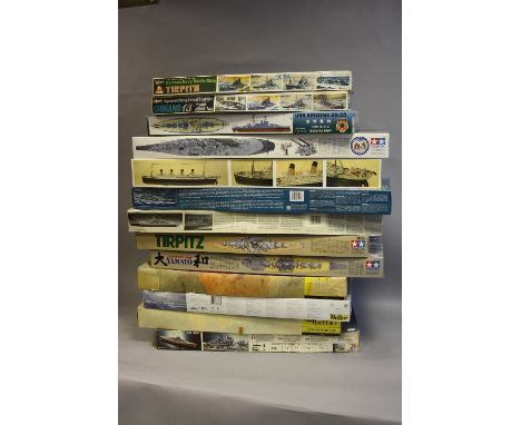
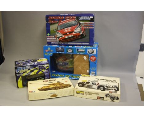
A COLLECTION OF 13 SCALE MODEL WARSHIPS AND MERCHANT SHIPS, 1 x Heller Bismark, scale 1:400, box opened. 1 x Hasegawa Tirpitz, 1:450, box opened. 1 x Heller Scharnhorst, 1:400, box opened. 1 x Hasegawa AC Shinano, 1:450, box opened. 1 x Heller HMS King George, 1:400, box sealed. 1 x Heller Tirpitz, 1:400, box opened. 1 x Mini Hobby Model USS Arizona 1:350, box sealed. 1 x Tamiya Tirpitz, 1:350, box opened. 1 x Revell USS New Jersey, 1:350, box opened. 1 x Revell USS Missouri, 1:350 box unopened. 1 x Tamiya Yamoto, 1:350, box opened. 1 x Acadamy Titanic, 1:350, box opened. 1 x Revell USS Missouri, 1:350 box unopened. Full contents not checked on all Models
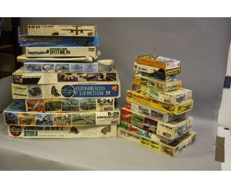
Lot 593
A COLLECTION OF 18 SCALE MODEL AIRCRAFTS,, includes 1 x Monogram B29 Super Fortress, 1:48 scale, box opened. 1x Airfix JU87b-2 Stuka, 1:24, box opened. 1 x Monogram B24J Liberator, 1:48, box opened. 1 x Airfix P.51D Mustang, 1/24, box opened. All others various manufacturers / models and scale, includes 1 box of model soldiers. Full contents not checked on all Models
Lot 594
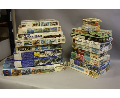
A COLLECTION OF 18 SCALE MODEL AIRCRAFTS, includes 1 x Revell Junkers JU88 A4, 1:48 scale, box opened. 1 x Monogram B29 Super Fortress, 1:48, box opened. 1 x Revell PBV-5A Catalina, 1:48, box sealed. 1 x Hasegawa Grumman F6F-3/5 Hellcat. All others various manufacturers / models and scale, includes 1 box of model soldiers. Full contents not checked on all Models
Lot 595
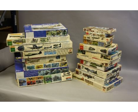
A COLLECTION OF 18 SCALE MODEL AIRCRAFTS, includes 1 x Revell Dornier DO217 E-5, 1:48 scale, box opened. 1 x Hasegawa Mitsubishi Type Zero 'Zeke', 1:32, box opened. 1 x Revell Mosquito Mk.V, 1:32, box opened. 1 x Monogram C-47 Skytrain, 1:48, box opened. All others various manufacturers / models and scale, includes 1 box of model soldiers. Full contents not checked on all Models
Lot 596
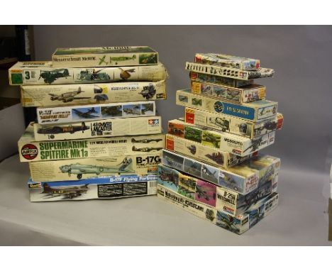
A COLLECTION OF 18 SCALE MODEL AIRCRAFTS, includes 1 x Revell B17F Flying Fortress, 1:48 scale, box opened. 1 x Tamiya Lancaster B1/B111, 1:48, box opened. 1 x Monogram B-17G Flying Fortress, 1:48, box opened. 1 x Airfix Supermarine Spitfire Mk1, 1:24, box opened. All others various manufacturers / models and scale, includes 1 box of model soldiers. Full contents not checked on all Models
Lot 609
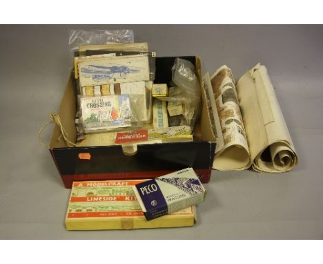
A QUANTITY OF UNBUILT VINTAGE AIRFIX AND SUPERQUICK CONSTRUCTION KITS, to include 1/72 scale Hawker Hurricane IV RP with type 1 header card, OO Gauge Trackside Series Country Inn, No.1, with type O header card, both still sealed in original packaging, three opened Airfix trackside accessory kits (one with header card), contents not checked, Superquick card kits Series A No's.1-4 still sealed in original packaging, three boxed 4mm Scale Model Equipment signals, unbuilt Peco Wonderful Wagon 10T side door open wagon kit, contents not checked but appears largely complete with instructions, empty Modelcraft Lineside Locomotive Shed Kit box (with instructions), Bilteezi card models sheets (rolled/folded), etc
-
216134 item(s)/page