We found 186094 price guide item(s) matching your search
There are 186094 lots that match your search criteria. Subscribe now to get instant access to the full price guide service.
Click here to subscribe- List
- Grid
-
186094 item(s)/page


Lot 1167
A GEORGE III MAHOGANY BRACKET CLOCK the breakarched and painted dial signed Perigal Coventry Street, with pierced hands and STRIKE/SILENT to the arch, the verge movement with bob pendulum and shouldered plates, in break arched case with brass mouldings and scale side frets, on ogee feet, 34.5cm h excluding handle ++Of very dry and dusty appearance, old scar on the mahogany arched top, much accretion of dirt and grime on the metal parts. Paint on the dial yellowed and scratched. Small old restorations

Lot 107
Thomson (John & Co., pub.). The Atlas of Scotland Containing Maps of each County, on a Scale so large as to Exhibit the Features of the Country and Places of Importance....., Accompanied with a Memoir of the Geography of Scotland, View of the Comparative Length of the Rivers, Heights of the Mountains and a Consulting Index to Facilitate the Finding out of Places &c., pub. Edinburgh, 1832, engraved frontis. of an index map, title page and dedication with short closed tear and slight staining, two large folding engraved plates of the comparative heights of the mountains and the lengths of the rivers in Scotland, both with bright contemp. hand colouring, twenty-nine (complete as list) engraved maps on thirty-eight sheets (some sheets conjoined), all with contemp. outline colouring, some staining and offsetting, occ. closed marginal tears, addn. duplicate map of Linlithgowshire loosely inserted, last few leaves of index at rear creased and a little frayed, contemp. half calf, boards detached, worn and frayed, folio. Chubb. Scotland 32 -1
Lot 138
Bartholomew (John). The Imperial Map of England & Wales According to the Ordnance Survey, with the Latest Additions; Shewing Clearly every Feature of the Country, Railays and their Stations, Roads, Canals, Rivers, Gentlemens Seats &c. &c. on a Scale of 4 Miles to an Inch, c.1860, double page litho. title and seventeen double page col. litho. maps (complete), one sheet with slight creasing and repaired marginal closed tears, some toning to index sheets, later endpapers, modern cloth with contemp. morocco gilt label to upper siding, slim folio -1

Lot 143
British Isles. Blaeu (Johannes), Magnae Britanniae et Hiberniae Tabula, c.1650, hand coloured engraved map, inset map of the Orkney Islands, strapwork cartouche, mileage scale and compass rose, very slight overall toning, 390 x 505mm, no text on verso. R.W.Shirley. Early Printed Maps of the British Isles, 1477 - 1650, no.423 (later state). -1

Lot 144
British Isles. Speed (John), The Kingdome of Great Britaine and Ireland, 1st ed, pub. J.Sudbury and G.Humble, c.1611, hand coloured engraved map, inset panoramas of London & Edinburgh, inset map of the Orkney Islands, strapwork cartouche and mileage scale, compass rose, trimmed to neat line and re-margined, slight mount staining, 380 x 505mm, English text on verso. R.W.Shirley. Early Printed Maps of the British Isles, 1477 - 1650 no.316. -1

Lot 145
British Isles. Desgranges, La carte des Royaumes dAngleterre dEscosse et dIrlande dediee a sa Majeste Britannique....., pub. paris, 1701, hand coloured engraved map by Roussel, inset maps of the English Channel and the Faroes, Orkneys and Shetland Islands, large ornate cartouche and mileage scale, 450 x 570mm. R.W.Shirley. Printed Maps of the British Isles 1650 - 1750 Desgranges 1 state 6 A separately published map, designed to support the claim of the Catholic monarch James II. Louis XIV had declared war on England in support of James, hoping to destroy the Anglo Dutch alliance that had brought William of Orange to the English throne. The supporting portraits by the cartouche are of James II, his wife Mary of Modena and their young son James, often called the Young Pretender. Very little is known about Desgranges, not even his Christian name or his birth and death dates. This is the last state (the first appeared in 1689, the year Louis declared war) with Desgranges name erased and repalced by Abbe Michel Baudrand. -1
Lot 146
British Isles. Visscher (Nicolas), Magnae Britanniae Tabula Angliam, Scotiam et Hiberniam, pub. Amsterdam, c.1670, engraved map with contemp. hand colouring, strapwork cartouche and mileage scale, toned overall, 450 x 530mm, together with De Lisle (Guillaume), Les Isles Britanniques ou sont le Royaumes DAngleterre...., pub. Covens & Mortier, Amsterdam, c.1720, engraved map with contemp. outline colouring, large decorative b & w cartouche, 480 x 580mm, plus, Tallis (John),The British Isles [and] England and Wales, c.1855, together two engraved maps with contemp. outline colouring, each map decorated with b & w vignettes, each approx. 345 x 255mm, together with three further maps by Munster, De Fer and Edwards, various sizes and condition -7

Lot 148
Cardiganshire. Speed (John), Cardigan Shire Described with the due forme of the Shiretown as it was surveyed by J.S. Anno 1610, 1st ed., pub. John Sudbury & George Humble, c.1611, hand coloured engraved map, inset town plan of Cardigan, large strapwork cartouche, mileage scale and compass rose, central fold strengthened on verso, slight worming affecting image, 390 x 515mm, English text on verso, mounted, together with, Caermarden Both Shyre and Towne described, pub. Thomas Bassett & Richard Chiswell, c,1676, hand coloured engraved map, inset town plan of Carmarthen, strapwork cartouche, mileage scale and compass rose, 385 x 510mm, English text on verso, mounted -2
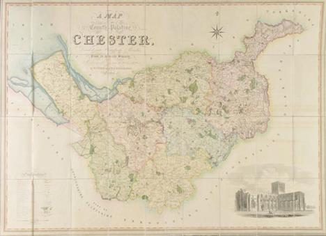
Lot 150
Cheshire. Swire (W. & Hutchings W.F.), A Map of the County Palatine of Chester, Divided into Hundreds and Parishes from an Accurate Survey made in the Years 1828 and 1829, pub. Henry Teesdale, 1830, large engraved map with contemp. hand colouring, sectionalised and laid on linen, calligraphic cartouche, b & w engraved vignette of Chester Cathedral, table of explanation and compass rose, slight staining, marbled endpapers, 970 x 1320mm, contained in contemp. burgundy morocco gilt book box, rubbed and worn at extrems. B.Kentish. A Catalogue of County Atlases of England and Wales 1607 - 1864 and large scale maps. 2012, Item 59 -1

Lot 155
Cornwall. Speed (John), Cornwall, pub. John Sudbury & George Humble, c.1627, uncoloured engraved map, inset view of Launceston, strapwork cartouche and mileage scale, two margins frayed and strengthened on verso, central fold partially strengthened on verso, 385 x 510mm, English text on verso -1
Lot 159
Dorset. Speed (John), Dorsetshyre with the Shyre-towne Dorchester described as also the Armes of such families as have bene honored with the Titles thereof since the Normans Conquest to this present, Anno 1662, pub. Christopher Browne, [1686], hand coloured engraved map, inset town plan of Dorchester, strapwork cartouche and mileage scale, trimmed to neat line and remargined, 383 x 505mm, mounted, together with, Blaeu (Johannes), Comitatus Dorcestria sive Dorsettia vulgo Anglice Dorset Shire, c.1660, engraved map with contemp. hand colouring, some overall toning, 385 x 505mm, French text on verso -2


Lot 185
Lancashire. Hennet (George), A Map of the County Palatine of Lancaster Divided into Hundreds and Parishes from an Accurate Survey made in the Years 1828 and 1829, pub. Henry Teesdale 1830, large map with contemp. hand colouring, engraved by James Bingley, sectionalised and laid on linen, calligraphic cartouche, b & w vignette of the New Custom House Liverpool, table of explanation, and compass rose, slight staining, 1600 x 1120, marbled endpapers, contained in contemp. red morocco gilt book box. B.Kentish. A Catalogue of County Atlases of England and Wales 1607 - 1864 and large scale maps. 2012 Item 68 -1

Lot 188
Maps. A good mixed collection of British county maps, 17th - 19th century, including Jansson (Jan),Comitatis Cantabrigiensis vernacule Cambridge Shire, c.1650, engraved map with contemp. hand colouring, ornate cartouche and mileage scale, some creasing, 415 x 515mm, together with, Speed (John),Wilshire, pub. John Sudbury & George Humble, c.1627, hand coloured engraved map, inset plan of Salisbury and an engraved vignette of Stonehenge, trimmed to neat line and laid on later card, 385 x 520mm, with, Jansson (Jan),Buckingamiae comitatus cum Bedfordiensi; vulgo Buckingamshire and Bedfordshire, c.1650, engraved map with contemp. hand colouring, some oxidisation to watercolour causing some cracking and splitting to image, backed with archival tissue on verso, slight staining and dust soiling, 410 x 510mm, Latin text on verso, plus six hand coloured engraved county maps by Richard Blome, two hand coloured engraved maps by Robert Morden, four hand coloured engraved maps by Thomas Moule, and a map of the British islands by Mercator, with another twelve maps, including examples by Kitchin/Jefferys, Hermannides, Beer, Dawson, Lewis, Laurie & Whitle, Kitchin and Reuben Ramble, plus two maps of Ireland by Mercator and Cloppenburgh, various sizes and condition (approx.30)
Lot 196
Northamptonshire. Blaeu (Johannes), Comitatus Northantonensis Vernacule Northanton Shire, c.1658, engraved map with contemp. hand colouring, large decorative cartouche and mileage scale, 415 x 505mm, French text on verso, together with Morden (Robert),Northamptonshire [1695 or later], hand coloured engraved map, 360 x 420mm, mounted -2
Lot 198
Nottinghamshire. Speed (John), The Countie of Nottingham described, The Shire Townes situation and the Earls thereof observed, pub. John Sudbury & George Humble, [1616], hand coloured engraved map, inset town plan of Nottingham, large strapwork cartouche and mileage scale, slight fraying to margins, repaired on verso, 380 x 510mm, Latin text on verso, mounted, together with Blaeu (Johannes),Comitatus Nottinghamiensis, Nottingham Shire, pub. Amsterdam, c.1648, engraved map with bright contemp. hand colouring, ornate cartouche and mileage scale, 385 x 500mm, French text on verso, mounted, with, Jansson (Jan), Comitatus Nottinghamiensis sive Nottinghamshire, c.1650, engraved map with faded contemp. hand colouring (possibly as a result of cleaning), 385 x 485mm, Latin text on verso, mounted -3

Lot 214
* Scotland. Blaeu (Johannes & Pont Timothy), Uistus Insula vulgo Uiist cum aliis minoribus ec Aebudarum Numero ei ad meridiem adjacentibus, pub. Amsterdam, c.1654, engraved map with contemp. hand colouring, inset map of Barra and its adjacent islands, large decoartive cartouche, 460 x 590mm, mounted, framed and double glazed, French text on verso, together with, Collins (Capt. Greenville),To the Honble. the Magistrates of the Citty of Aberdeene....., c.1700, uncoloured engraved sea chart, inset maps of Aberdeen and Montrose, compass rose and numerous rhumb lines, 445 x 560mm, mounted, framed and glazed, with, Dartmouth. To the Right Honorable George, Lord Dartmouth....., Dedicated and Presented by G.Collins, c.1700, hand coloured engraved sea chart, inset map of Tarr Bay, ornate cartouche and mileage scale, three inset horizon profiles, some overall toning, 455 x 575mm, mounted, framed and glazed -3

Lot 219
South Atlantic Ocean. Jansson (Jan), Mar Di Aethiopia vulgo Oceanus Aethiopicus, c.1660, engraved map with contemp. outline colouring, ornate cartouche and mileage scale, compass rose and numeous rhumb lines, slight creasing, slight staining, 440 x 550mm. Published in Janssons Atlas Maritimus. -1

Lot 229
Wales. Mercator (Gerard, Jansson Jan & Lhuyd Humphrey), Cambriae Typus Auctore, Humfredo Lhuydo Denbigiense Cambrobritanno, c.1660, uncoloured engraved map, decorative cartouche and mileage scale, compass rose and numerous rhumb lines, 355 x 490mm, mounted. John Booth. Antique Maps of Wales. no.5. -1
Lot 230
Wales. Ogilby (John), The Road from Priestaine in Com. Radnor to Carmarthen, c.1676, uncoloured engraved strip road map, with page of descriptive text, 320 x 455mm, mounted, together with, Speed (John),The Countie of Radnor Described and the Shyretownes sittuatione, pub. Thomas Bassett & Richard Chiswell, c.1676, hand coloured engraved map, inset town plan of Radnor, strapwork cartouche, mileage scale and compass rose, central fold strengthened on verso, occ. marginal closed tears, slight overall toning, 390 x 515mm, English text on verso, with, Blaeu (Johannes),Comitatus Brechiniae, Breknoke, c.1658, engraved map with contemp. hand colouring, 380 x 510mm, French text on verso, mounted, plus, Morden (Robert),A New and Correct Map of North Wales, c.1722, hand coloured engraved map, 365 x 430mm, mounted -4

Lot 231
Wiltshire. Andrews (John & Dury Andrew), A Topographical Map of Wiltshire, on a Scale of 2 Inches to a Mile from an Actual Survey by John Andrews & Andrew Dury, 1st. ed., 1773, engraved map with contemp. hand colouring, on eighteen sheets (complete), each sheet laid on later linen, slight creasing and dust soiling, trimmed to neat lines, the sheet showing the cartouche has had the image trimmed and excised and re-laid on contemp. matching paper, each sheet approx. 460 x 635mm, contained in modern purpose made blue cloth gilt portfolio. B.Kentish. Large Scale Maps of England and Wales, 1705 - 1832 Item no.62. -1

Lot 419
* Caruso (Enrico, 1873-1921). A large caricature self-portrait, 1914, pen and brown ink on paper, signed and dated London 1914, inscribed To Dikkino, 30 x 24cm (11.75 x 9.5ins), with additional inscription on pale brown paper Per Mister Dick separately mounted below, framed. An unusually fine and large-scale self-caricature by Caruso, given to the famous baritone Riccardo Stracciari during Carusos last season of performances at Covent Garden. -1


Lot 1059
JOSEPH EDWARD SOUTHALL R.W.S., R.B.S.A., N.E.A.C. (1861 - 1945) Framed, unsigned, watercolour and pencil on paper, scale drawing of `The Five Virtues` between columns, and decorative frieze above, 17.5cm x 40cm. Provenance: By family descent; Exhibited at the Fine Art Society, July 1978 and `Joseph Southall 18611944: Artist-Craftsman, London, 1978` exhibition, 8th August 1980 - 30th September 1980, catalogue no. I5, Birmingham Museum and Art Gallery, see exhibition labels verso. (ARR).


Lot 91
A GROUP OF 18TH CENTURY ENGLISH PORCELAIN TEAWARES, c. 1770-1790, to include two Worcester 'scale blue' tea saucers, two Worcester 'Queens' pattern coffee cups, a Worcester blue printed 'Bell Toy' pattern saucer, a Caughley blue and gilt teacup and saucer, a Derby blue and gilt teabowl and saucer, a Chelsea Derby cream jug with green floral swags and a teabowl of the same pattern (11)

Lot 1167
A late 19th century Samson porcelain box, painted with putto, in puce within scale borders, blue crossed swords mark with 'S', 8.5cm wide, together with a Continental tin glaze enamel box painted with a courting couple, unmarked, 6.5cm wide (2) CONDITION REPORT: Samson has wear to gilding, otherwise no obvious faults. Top detached from Puce box. Enamel box has a chip and crack to corner of lid.

Lot 1349
Francois-Antoine Jecker, brass folding gold coin scale, circa 1800, the beam with large rectangular sliding poise, one end with shovel shaped pan, the other with a hook on brass four gros weight, beam inscribed 'Jecker, Paris', within a fitted mahogany case with applied printed label titled 'Noms Des Monnaies' being a table of gold monies taking place in the various states of Europe with the denomination of their weight

Lot 1357
Attributed to A Wilkinson, a brass folding guinea scale, circa 1786, the circular weight pan with slightly raised sides for taking flat bound weights, within a mahogany case with three flat weights to weigh guinea, half guinea and seven shillings, 13.2cm See Weighing Coins by Michael A Crawforth, page 65, figure 27, for an identical scale


Lot 1366
An English coin scale, late 17th/early 18th century, having a steel beam with swans neck ends and brass pans, all within a fruitwood cut from solid box, with decorative book binder style stamped decoration, similarly struck to the underside lid and with a plush red lined base, housing weights for old and new standard guinea, half guinea and seven shillings and six grain weights, beam 8.5cm

Lot 1368
John & Obadiah Westwood, a set of miniature polished steel and brass coin scales, the turned beam with swans neck ends, with six grain weights, the larger stamped 'Westwood', all within a shagreen covered case with plush interior and with applied label with old and new guinea rate scale, inscribed 'by J N and Oba Westwood, Birmingham', beam 6cm CONDITION REPORT: Grain weights slightly bent. Minor 'ding' to edge of one scale dish. Some surface wear and green corrosion (?) spots. General surface wear to case.


Lot 1373
Freeman & New, a set of polished steel and brass coin scales, circa 1780, the turned beam with swans neck ends and brass pans, all within a cut from solid mahogany case, the lid interior with applied trade label for 'Freeman & New, Leadenhall St, London, Scale Makers to His Majesty's Mint Exchequer, Bank of England …', with tapering cylindrical guinea, half guinea weights, beam 12.3cm
-
186094 item(s)/page