We found 216134 price guide item(s) matching your search
There are 216134 lots that match your search criteria. Subscribe now to get instant access to the full price guide service.
Click here to subscribe- List
- Grid
-
216134 item(s)/page


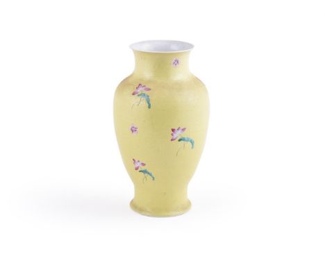
Lot 217
A Chinese yellow-ground vase, probably Xuantong or Republican Period, the surface with sgraffiato ground with scrolling foliage and painted in Famille Rose enamels with scattered flowers, the base and interior turquoise white, incised apocryphal Qianlong seal mark in iron-red to base, approximately 30cm highProvenance: Private collection formed largely in the 1980's and 1990's. 民国 黄地花卉图瓶拍品来源:英国私人收藏Condition Report: shallow scale chip to yellow enamel on edge of foot rim measuring approximately 6mmx 4mm Condition Report Disclaimer
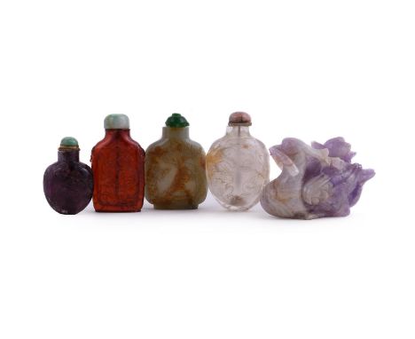
Lot 93
Four Chinese snuff bottles, Qing Dynasty, comprising: a celadon jade and russet 'pebble' bottle, carved with a sage and boy under a pine tree, the snuff bottle 6.8cm high, with later glass stopper; a rock crystal bottle, carved with dragons, the snuff bottle 7cm high with pink banded hardstone stopper and overall height 8cm; an amber snuff bottle, carved with a figure, pine tree and deer, the snuff bottle 6.8cm high, with jadeite stopper and overall height 8cm and an amethyst snuff bottle, carved with mythical beasts and foliage, the snuff bottle 5cm high, with jadeite stopper and overall height 6.4cm and an amethyst model of a mandarin duck, 10cm long (5) Provenance: From a Noble English family, the snuff bottles prior to 1921. The 1st Earl Mountbatten of Burma, and thence by descent. 清19世纪 琥珀鼻烟壶等各式一组四件及紫水晶鸳鸯摆件一件拍品来源:英国显赫贵族收藏,购自1921年前 Condition Report: the glass stopper damaged on the jade snuff bottlenatural faults and brown inclusions to rock crystal bottle and stopper with flawthe amber bottle with 6mm x 3mm rim chip and stopper with flawthe amethyst bottle with shallow scale chip 3mm x 4mm the duck with several long cracks Condition Report Disclaimer
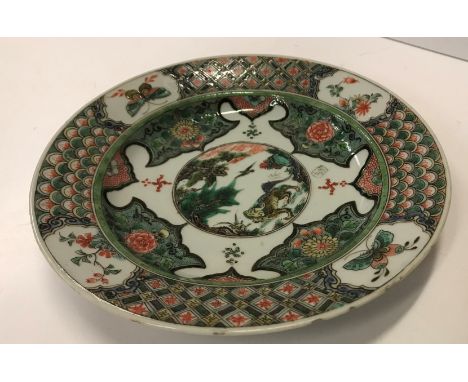
Lot 126
A Chinese Kangxi famille verte plate, the centrefield decorated with kylin in a landscape and Swastikas, within a stylised dragon scale and lattice work decorated border, set with panels of butterflies and flowers, raised on a circular foot, bearing lozenge mark within two concentric rings to base, 22 cm diameter CONDITION REPORTS Some small nibbles to the edge of the plate throughout, some firing faults and hairline crack from the outside of the plate towards the foot almost to the actual foot itself. Nibbles to the base of the foot and split to the glaze of the base approx. 2.5 cm - see images for further detail - otherwise wear and tear conducive with age and use
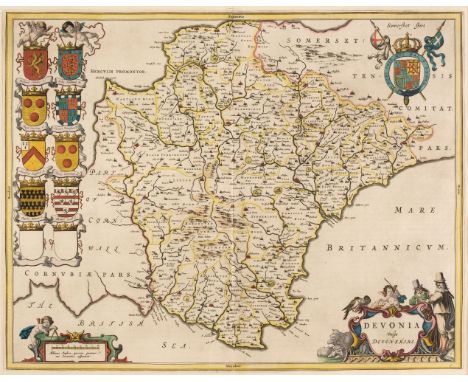
Lot 101
Devon. Blaeu (Johannes), Devonia vulgo Devonshire, Amsterdam, circa 1645, engraved map with contemporary hand-colouring, decorative cartouche and mileage scale, 390 x 505 mm, mounted, framed and glazed, together with Blome (Richard). A Mapp of Devon Shire with its Hundreds, circa 1673, hand-coloured engraved map, some fraying and loss to the upper margin but not affecting the image, 255 x 315 mm, mounted, framed and glazedQty: (2)
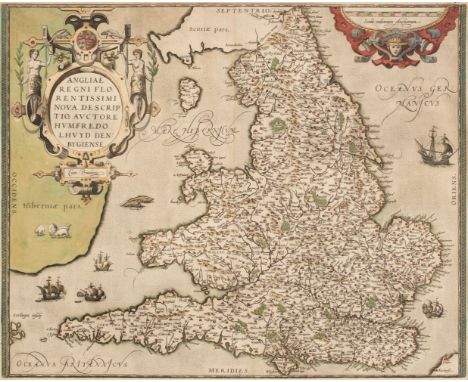
Lot 104
England & Wales. Ortelius (Abraham & Lhuyd Humphrey), Angliae Regni Florentissimi nova descriptio auctore Humfredo Lhuyd Denbygiense [1573 - 84], engraved map with contemporary hand-colouring, large strapwork cartouche and mileage scale, 380 x 470 mm, mounted, framed and glazedQty: (1)Footnote: Marcel Van den Broecke. Ortelius Atlas Maps, no. 19.
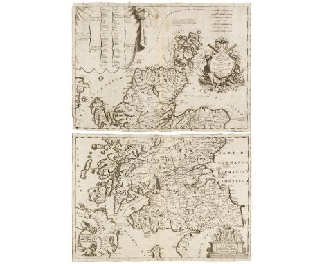
Lot 136
Scotland. Coronelli (Vincenzo Maria), Scotia Parte Settentrionale..., & Scotia Parte Meridionale..., Venice, circa 1700, two sheet uncoloured engraved map, not conjoined, each with an elaborate cartouche and mileage scale, old folds, narrow margins, slight staining, each sheet approximately 450 x 625 mm, together with 6 sheets from the same publication including an engraved coat of arms, a small map of Scotland, a view and a plan of Edinburgh, sheet size 190 x 270 mm, with Van den Keere (Pieter). The Kingdome of Scotland, circa 1627, uncoloured engraved miniature map, slight water staining, 85 x 125 mm, English text on verso, together with another late 18th-century map of Scotland with contemporary outline colouring, engraved for 'Walker's Geography, 190 x 220 mmQty: (10)
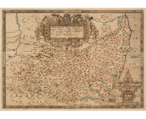
Lot 140
Suffolk. Saxton (Christopher), Suffolciae Comitatus continens in Se oppida Mercatoria 25 Pagos et Villas 464 una cum singulis hundredis et fluminibus in eodem vera descriptio, [1579], engraved map with contemporary hand colouring and some later enhancement, slight spotting, large strapwork cartouche and mileage scale, laid on later paper, 340 x 485 mmQty: (1)Footnote: The first printed map of Suffolk with the 'bunch of grapes' watermark.
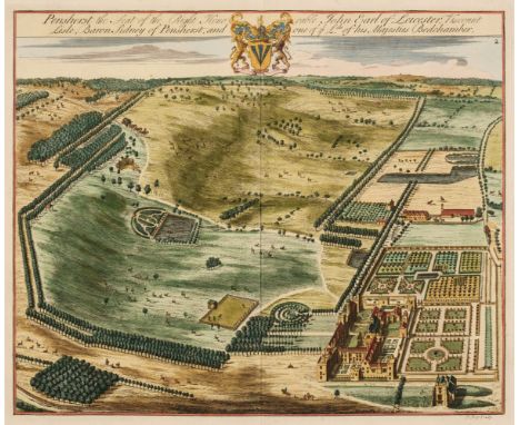
Lot 201
Kent. Kip (J. & Harris J.), Six aerial prospects of country estates, Penshurst the seat of the Right Honorable John Earl of Leicester..., (2 copies), Squerries at Westram in Kent, Chepsted Place one of ye Seats of David Polhill Esqr. The Seat of Pendock Price Esqr. at Westram [and] Sunbridge Place, Bore Place & Sharps Place, the Seats of John Hyde Esq. originally published in Dr Harris's 'History of Kent...', circa 1728, six engraved aerial prospects, two with later hand-colouring, each approximately 350 x 420 mm, together with Hassell (J.). Belvidere House Kent, the seat of Lord Earley, Westerham - Kent, Riverhead - Kent, Hever Castle - Kent, Tunbridge - Kent & Foots Cray - Kent, 1818, six miniature aquatints with contemporary hand-colouring, each approximately 75 x 95 mm, with Hasted (Edward). A Map of Westerham & Eaton Bridge Hundred with the Parish and Ville of Brasted and the Hundred of Somerden, [1778], hand-coloured engraved map, two marginal repaired closed tears, 395 x 390 mm, with Andrews (John & Dury Andrew). Large scale map of Kent, Sheets 6 and 11 only [1769], two double-page engraved maps of parts of Kent, each with contemporary outline colouring, each approximately 480 x 670 mmQty: (15)
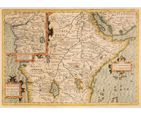
Lot 75
Africa. Mercator (Gerard & Hondius Henricus), Abissinorum sive Pretiosi Joannis Imperiu, circa 1610, hand-coloured engraved map, ornate strapwork cartouche and mileage scale, inset map of the 'Congi Regni', one vertical crease, slight dust soiling and mount staining, 345 x 490 mm, Dutch text on verso, together with Chatelain (Henri Abraham). Carte Du Royaume De Congo Du Monomotapa et de la Cafrerie..., Paris, circa 1717, hand-coloured engraved map, some creasing, central fold partially strengthened on the verso, 410 x 520 mm, with Hondius (Jodocus). Guineae Nova Descriptio, Amsterdam, circa 1615, engraved map with contemporary hand-colouring, inset map of the Isle of St Thomas, heavily oxidised with subsequent cracking and splitting to the paper affecting the printed image, strengthened and repaired on the verso, 350 x 495 mm, French text on the versoQty: (3)
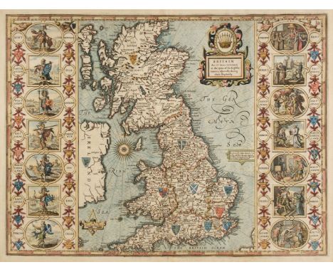
Lot 89
British Isles. Speed (John), Britain as it was divided in the tyme of the Englishe Saxons especially during their Heptarchy, Thomas Bassett & Richard Chiswell [1676], hand-coloured engraved map, ornamental strapwork title cartouche and scale of distance surmounted by open dividers, compass rose and numerous rhumb lines, fine strapwork side borders depicting historical figures and scenes, 385 x 510 mm, mounted, framed and double-glazed, English text to verso,Qty: (1)
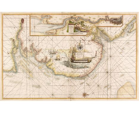
Lot 99
Collins (Captain Greenville). Untitled chart of the East coast of England, circa 1700, large hand-coloured engraved chart, showing the coastline from Dover to the River Humber, orientated to the west, large inset map of the River Thames and London, dedication and mileage scale placed on the sails of a large vignette of a man-of-war, old folds, slight dust soiling and creasing, some folds strengthened on the verso, 600 x 940 mmQty: (1)


-
216134 item(s)/page