We found 216134 price guide item(s) matching your search
There are 216134 lots that match your search criteria. Subscribe now to get instant access to the full price guide service.
Click here to subscribe- List
- Grid
-
216134 item(s)/page
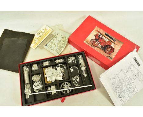


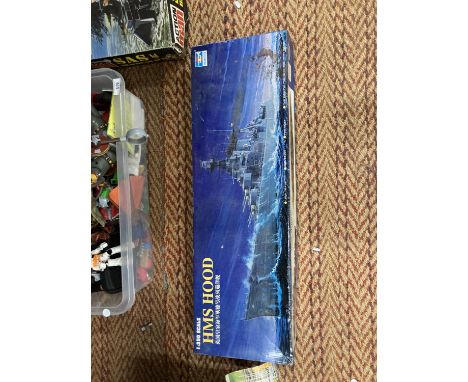
Lot 335
AN UNBOXED FRANKLIN MINT BOEING B-17G FLYING FORTRESS, 1:96 scale, with certificate of authenticity, swing tag and display stand, appears complete and in fairly good condition, with an unboxed Franklin Mint Crescent Limited HO gauge locomotive and tender, with swing tag, assorted diecast and plastic 1:72 scale helicopter models from the Amer.com partwork series (no literature), all have damage, wear and loose/missing items, with a quantity of assorted HO plastic buildings, Kibri, Vollmer etc (3 boxes and loose)
Lot 1977
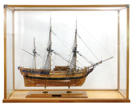
Armed Transport Bounty, The.: Fein detailliertes Schiffsmodell aus Holz im Schaukasten. Maßstab 1:48. Ca. 84 x 28 x 70 cm (LxBxH), Schaukasten ca. 107 x 46 x 86 cm (LxBxH). Modell des Dreimasters der britischen Admiralität, der 1787 zu einer Reise in die Südsee aufbrach. Auf der Rückreise 1789 kam es zur berühmten Meuterei. - Guter Zustand. Abholung oder Versand durch Spedition. - Provenienz: Christies, Auktion 1992. - Detailed ship model of the Bounty in display case. Scale 1:48. Good condition. Pick-up or dispatch by forwarding agent. D
Lot 1978
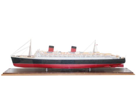
RMS Queen Elizabeth.: Schiffsmodell, um 2000. Maßstab 1:250. Ca. 125 x 13 x 29 cm (LxBxH). Vitrine aus Holz u. Plexiglas (ca. 139 x 25 x 39 cm). Detailliertes Modell des Passagierdampfers der Cunard Steamship Company. Die Indienststellung erfolgte 1940. - Guter Zustand. Abholung oder Versand durch Spedition. - Detailed ship model of the RMS Queen Elizabeth. Released around 2000, scale 1:250, base made of wood and Plexiglas. - Good condition. Pick-up or dispatch by forwarding agent. R
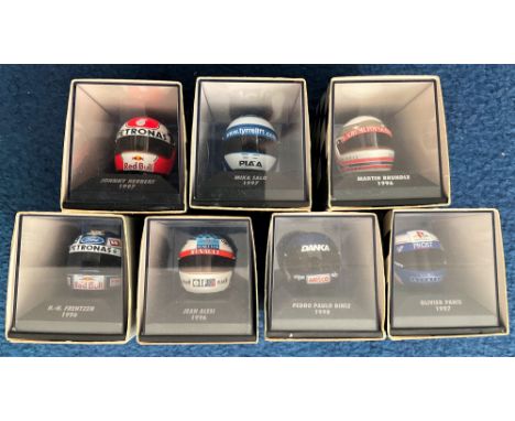
Lot 450
7 x Minichamps Helmet Collection, Miniature Helmets of F1 Drivers 1/8th Scale including Olivier Panis 1997, Martin Brundle 1996, Mika Salo 1997, Johnny Herbert 1997, H H Frentzen 1996, Jean Alesi 1996, Pedro Paulo Diniz 1998. Good condition We combine postage on multiple winning lots and can ship worldwide. UK postage from £4.99, EU from £6.99, Rest of World from £8.99
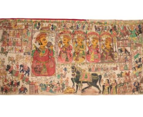
Lot 141
A PABUJI PHADA, RAJASTHAN, EARLY 20TH CENTURY pigment with ink on cotton, of long, horizontal rectangular form, devanagari inscription next to the main image 445 x 142cm For a related phada in the Calico Museum, Ahmedabad, see Kay Talwar and Kalyan Krishna, 'Indian Pigment Paintings on Cloth', Ahmedabad 1979, p.101ff, no.120. Pabuji is a folk hero in Rajasthan who lived in the fourteenth century and has since gained semi-divine status. In this large scale composition, the hero is depicted holding a sword and lotus, and accompanied by his four generals. Other scenes include episodes from his life, along with others shown as comparisons with his deeds. Below is the beautiful black mare presented to him by Charani Deval, a form of Shakti. The story is told that the goddess gave the horse in exchange for an unconditional promise to defend her herd of cattle. On the day of Pabuji's wedding, the cattle were stolen, and in the battle to retrieve them, the hero was killed. ++Some wear, fading and minor colour run
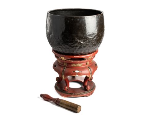
Lot 314
*A CUP GONG (DOBACHI), JAPAN, DATED 1565 A.D. beaten copper alloy, of bowl shaped form, the lower sides with scale motifs in relief, inscribed around upper edge in Japanese, together with later lacquer stand and leather lined turned wood beater 31cm high; 41cm wide The inscription has been part translated: 'Ei Roku, eight year, third month, Kyoto South Zen temple, treasure...Oda Nobunaga'. A transcription is sold with this lot. Oda Nobunaga, known as the Demon King, was a feudal lord and one of the most important figures in 16th century Japan. See footnote to lot 312 ++Slight knocks, stand and beater with some damage
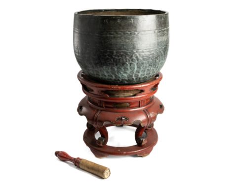
Lot 315
*A CUP GONG (DOBACHI), JAPAN, DATED 1682 A.D. beaten copper alloy, of bowl shaped form, the lower sides with scale motifs in relief, inscribed around upper edge in Japanese, together with later lacquer stand and leather lined turned wood beater 32cm high; 44cm wide The inscription has been part translated: 'Tenwa, second year (year of dog), fourth month, lucky day...Janen temple treasure'. A transcription is sold with this lot. See footnote to lot 312 ++Greenish patina, mostly good, stand and beater with a few knocks

Lot 317
*A CUP GONG (DOBACHI), JAPAN, DATED 1782 A.D. beaten copper alloy, of bowl shaped form, the lower sides with scale motifs in relief, inscribed around upper edge in Japanese, together with later lacquer stand and modern turned wood beater 34.5cm high; 47cm wide approx. The inscription has been part translated: 'The ninth month of the second year of Tenmei (1782), a good/lucky day, Hyogetsu temple, Mt. Tomyo'. A prayer is included. A transcription is sold with this lot. See footnote to lot 312 ++Stand damaged with loose joints
Lot 318
*A CUP GONG (DOBACHI), JAPAN, CIRCA 18TH CENTURY beaten copper alloy, of bowl shaped form, the lower sides with scale motifs in relief, inscribed around upper edge in Japanese, together with modern cushion stand and turned wood beater 26cm high; 36cm wide See footnote to lot 312 ++Minor dents
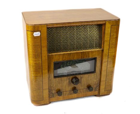
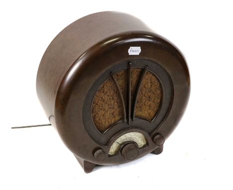
Lot 67
mid 1930s, with separate waveband indicator and magic eye to tuning scale, bakelite surround below metal grille speaker, in butterfly-cut walnut and mahogany veneered cabinet; together with the Marconiphone equivalent with similar features and scale. (2)Radios untested, cosmetically in Excellent original condition, some light wear from use


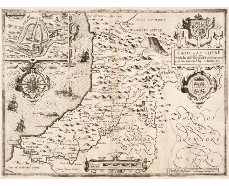
Lot 111
Cardiganshire. Speed (John), Cardigan Shyre Described with the due forme of the Shiretown as it was surveyed by J. S. John Sudbury & George Humble circa 1614, uncoloured engraved map, inset town plan of Cardigan, large strapwork cartouche, compass rose and milage scale, slight staining, two wormholes to the lower margin but not affecting the printed surface, 380 x 510 mm, English text on verso, together with Kitchin (Thomas). An Accurate Map of Cardigan Shire Drawn from an Actual Survey with Various Improvements..., circa 1765, engraved map with contemporary outline colouring and some later enhancement, lower margin trimmed to the neatline with a later paper extension, 345 x 530 mm, mounted, framed and glazedQTY: (2)
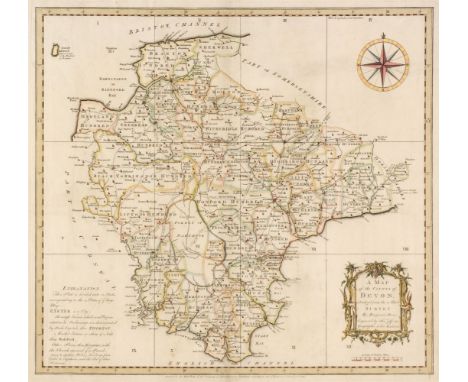
Lot 114
Devon. Donn (Benjamin), A Map of the County of Devon, abridged from the 12 sheet Survey, February 1st 1765, hand-coloured engraved map by Thomas Jefferys, decorative cartouche, compass rose and table of explanation, slight spotting, 505 x 545 mm, together with Bowen (Emanuel). An Accurate map of Devon Shire Divided into its Hundreds, Drawn from the best Authorities..., Carington Bowles & Robert Sayer, circa 1765, engraved map with contemporary outline colouring and some later enhancement, inset plan of Plymouth, long repaired closed tear affecting the printed surface, central fold strengthened on the verso, occasional marginal closed tears, slight staining and dust soiling, 535 x 680 mmQTY: (2)NOTE:Batten & Bennett, The Printed Maps of Devon, 45. Published as the key plate for Donn's large scale map of Devon but often found as a separate map.
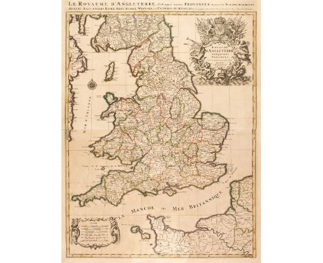
Lot 120
England & Wales. Jaillot (Alexis-Hubert & Sanson Nicolas), Le Royaume d'Angleterre distingué en ses Provinces..., Paris, [1693], large engraved map with contemporary hand colouring, large uncoloured decorative cartouche and mileage scale, toned overall, 780 x 585 mm, together with Tirion (Isaak). Nieuwe Kaart van de Eilanden van Groot Brittannien..., Amsterdam, circa 1770, engraved map with contemporary outline colouring, inset map of the Orkney and Shetland islands, 330 x 375 mm, with Chatelain (Henry Abraham), Carte du Gouvernement Militaire de l'Angleterre ou l'on Represente l'Etat des Officiers de Guerre et celui des Forces de Terre et de Mer, circa 1708, hand-coloured engraved map of the British Isles with a historical tableau on either side of the map and French text below, overall size 350 x 465 mm, mounted, plus another 14 maps similar, including examples by or after Albrizzi, Vertue, Muller, Nolin, Bickham and Du Laporte, various sizes and conditionQTY: (17)NOTE:The first described map. R. W. Shirley. Printed Maps of the British Isles 1650 - 1750, Jaillot 2, state 2.
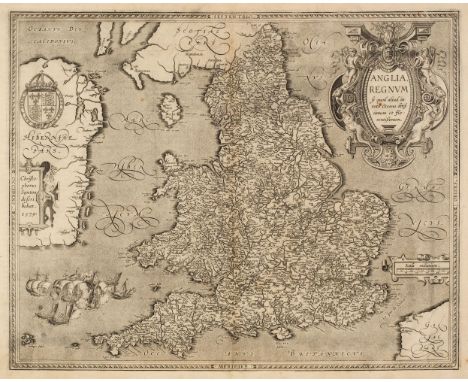
Lot 123
England & Wales. Ortelius (Abraham & Saxton Christopher), Anglia Regnum si quod aliud in toto Oceano ditissimum et florentissimum, Jan Baptist Vrients, Antwerp [1603], uncoloured map engraved by Pieter van den Keere, large decorative cartouche and strapwork mileage scale, additional strapwork cartouche paying tribute to Christopher Saxton and a large maritime vignette commemorating the attack of the Spanish Armada to lower-left, large margins, central fold and lower margin professionally restored on verso, 385 x 485 mm, Latin text on versoQTY: (1)NOTE:R. W. Shirley, Early Printed Maps of the British Isles 1477 - 1650, 258. Marcel Van den Broecke, Ortelius Atlas Maps, 20.
Lot 129
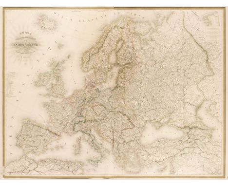
Europe. Andriveau (J. & Goujon J.). Carte Physique et Politique de l'Europe, Paris, 1843, large engraved map with contemporary outline colouring on two conjoined sheets, 975 x 1285 mm, together with De Vaugondy (Robert). L'Europe Divisée en ses Principaux Etats..., Paris, 1751, engraved map with contemporary outline colouring and some later enhancement to the cartouche and mileage scale, central fold split at the base and partially repaired on verso, 485 x 580 mm, with Philip (George & Son, publishers). Europe, circa 1860, lithographic map with contemporary outline colouring, one short marginal closed tear, 515 x 620 mm, plus Bartholomew (J. publisher). Europe, Edinburgh, circa 1880, colour printed photolithographic map, 430 x 550 mmQTY: (4)
Lot 150
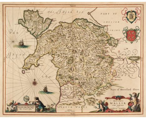
North Wales. Jansson (Jan), Principatus Walliae pars Borealis vulgo North Wales, Amsterdam, circa 1648, engraved map with contemporary outline colouring, decorative cartouche and mileage scale, compass rose and numerous rhumb lines, slight staining, but largely confined to the margins, 405 x 515 mm, Latin text on verso, together with Bowen (Emanuel). A Map of the Six Counties of North Wales Divided into their respective Hundreds..., H. Parker, J & C Bowles, H, Overton, J. Ryall, R. Sayer and T. Kitchin, circa 1762, engraved map with contemporary outline colouring, originally published in 'The Royal English Atlas', one small rust stain, 410 x 515 mm, with Schenk (P. & Valk G.). Principatus Walliae pars Borealis vulgo North Wales, Amsterdam [1714 - 24], engraved map with contemporary outline colouring, decorative cartouche and mileage scale, compass rose and numerous rhumb lines, 405 x 515 mm, no text on verso, plus Mercator (Gerard & Hondius Henricus). Westmorlandia, Lancastria, Cestria, Caernarvan, Denbigh, Flint, Merionidh, Montgomery, Salopia cum insulin Mania et Anglesey, circa 1630, uncoloured engraved map, 360 x 415 mm, Latin text on versoQTY: (4)
Lot 175
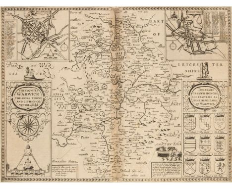
Warwickshire. An album containing maps of Warwickshire, 17th - 19th century, engraved maps by or after Speed, Jansson, Blaeu, Saxton/Kip, Blome, Jefferys, Moll, Seller, Badeslade & Toms, Harrison, Van den Keere and Ordnance Survey, mostly uncoloured and partially or wholly laid onto an album sheet, the Ordnance Survey map is 16 sheets on a scale of 1 inch to 1 mile, 2 copies of the Saxton/Kip (both appear to be the 1610 edition, 2 copies of the Blome and the John Speed is the 1st edition with thread margins, occasional duplicates, various sizes and condition, all bound in a late 19th century half morocco album, boards worn and stained, slight wear to extremities, folio QTY: (1)
![Worcestershire. Speed (John), Worcestershire Described, John Sudbury & George Humble [1616], hand-coloured engraved map,](https://cdn.globalauctionplatform.com/e9dc0ac2-559f-4025-a874-ae7e01100a9c/ce7a25b5-ea63-4071-b5de-ae7f00f6f85b/468x382.jpg)
Lot 176
Worcestershire. Speed (John), Worcestershire Described, John Sudbury & George Humble [1616], hand-coloured engraved map, inset town plan of Worcester, large strapwork cartouche and compass rose, central fold strengthened on verso, 380 x 500 mm, Latin text on verso, together with Doharty (John). A Plan of the City of Worcester with References, 1741, uncoloured engraved city plan, slight creasing and dust soiling, one repaired closed tear affecting the printed image, 475 x 585 mm, with Moll (Herman). Worcestershire, circa 1720, hand-coloured engraved map, the vertical margins decorated with antiquities, 195 x 315 mm, plus Schenk (P. & Valk G). Wigoriensis comitatus cum Warwicensi nec non Coventriae Libertas, Amsterdam, circa 1700, engraved reticulated map with contemporary hand-colouring, uncoloured cartouche, heraldic shields and mileage scale, 430 x 520 mm, and Van den Keere (Pieter). Worcestershire, circa 1627, hand-coloured engraved miniature map, small margins, 85 x 125 mm, English text on versoQTY: (5)
Lot 29
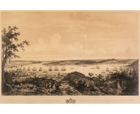
Schranz (Joseph 1803-circa 1866). Mouillage des Flottes Anglo-Francaises Turque et Egyptienne dans le Bosphore, Octobre 1853, de la Rade de Beikos jusqu'à Buyuk-Déré (vue prise de la côte d'Asie),.../ Anchorage of the English-French, Turkish & Egyptian fleets in the Bosphorus, October 1853, from the road of Beikos up to Buyuk-Déré (taken from the Asiatic Coast), large-scale tinted lithograph by Sabatier and Bayot (shipping by Schranz), after Joseph Shranz, evenly-spaced vertical creases across the image with additional creasing, several repaired tears with small areas of loss to the printed surface, toned overall, mount stained, laid down on to later backing card, 830 x 1210 mmQTY: (1)
Lot 345
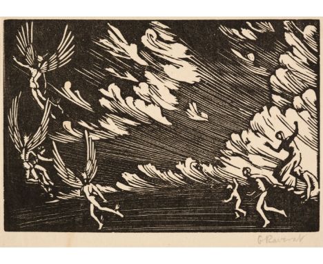
Raverat (Gwen 1885-1957). An album of 155 wood engravings by Gwen Raverat, 1909-28, compiled by the artist as a personal record of her work, containing 155 wood engravings, of which 65 (some with initials) are signed in pencil, many also titled in pencil, with handwritten name and address of the artist in pencil to front pastedown 'Gwendolen Raverat, Villa Adele, Vence, Alpes Maritimes', all engravings mounted on album leaves with titles and dates in the artist's hand in ink to lower margin, handwritten index by the artist in ink to first leaf, with some corrections and alterations, original plain cream cloth, rubbed, some marks and soiling, folio (leaves measure 32 x 25.5 cm, 12 1/2 x 10 ins)QTY: (1)NOTE:Provenance: Estate of the artist, thence by descent.Selborne & Newman 1-28, 30-38, 40-52, 54-60, 62-75, 77-89, 91-100, 102-106, 109-137 & 139-147.An important album compiled by the artist Gwen Raverat, containing a near-comprehensive selection of her early output between 1908 and1928, including many rare proofs. This collection provides a survey of the artist's output up to 1928, and includes her first wood engraving, The Knight of the Burning Pestle (1909), early works on the English ballad tradition, such as May Margaret, Fair Annie, Windy Day, Despair, The Marsh, Child Stealers, Bookplate for Geoffrey Keynes, The Witch, Nightmare, Sir Patrick Spens Ballad, Sailor's Wife, Boys by a Pond, Cobbled Yard, Annie of Rough Royal, Ballad, Travellers, Margaret's Ghost, Ballad, Clark Saunders, and The Quarrel, all 1909, engravings from the years 1910 to 1912, including Wood Nymph, May Margaret's Return, Sir Thomas Browne (numbers 1 and 2), The Dead Knight, the Brown Girl, two bookplates (1910), Prodigal Son, May Morning, Anthony & Cleopatra, The Palmer, The Retreat, Flying, Gypsies, King Lear, A Dream, The Little Visitation, The Creation of Light (drawn by Jacques Raverat, and cut by Gwen Raverat), Pieta, The Wood, The Storm, The Visitation, Shepherds, and The Manger, works produced from 1913 and through the First World War include: Shepherds (1914), The Dead Christ (1913), Baptism (drawn by Jacques Raverat), Mary & Elizabeth (1913), Haycocks, Bookplate for Lady Robert Cecil, Full Moon, The Hobby Horse (two versions), Judas Dead, Sky, Autumn Morning, Prodigal Son (drawn by Jacques RaveTrees & Pear Tree (signed and titled by the artist 'Noyers et Poiriers', The Avenue, Hoeing, Portrait of W. E. Darwin, The Edge of the Wood (numbers 1, 2 & 3), The Moor, Poplars in France, The Summit, Winter Morning, Elms by a Pond, The Poacher, Le Pelvoux (drawn by Jacques Raverat), The Goose Herd, Lost Traveller, Sheep, Sheep by a River, Houses, The Farm Pond, Primrose Wood, Boys Bathing, Portrait of Rupert Brooke, and Title page design for Poems of Rupert Brooke. Post-war works include Women Bathing, Bathsheba, the large scale Dancing Boys (1920), Duck Pond, Village Street, The Bolshevist Agent (numbers 1 & 2), cover design for Shadows of the Christ, Portrait of Jacques Raverat, Sleeping Beauty, David Old (first state), Crashaw's Shepherds Hymn.Views in the South of France include Jeu de Boules, Vence (1922), Olive Pickers, the large scale Adam & Eve (marked 'only print' in pencil), Streets by moonlight (large and small versions), Boules Players, The Philosopher, La Place en Hiver (1923), The Fourteenth of July-La Farandole (1923, Scandel, The Farmer's Wife, The Sexton, The Barber's Shop, La Place en Eté, The Fair Sex, The Middle of the Night, The Bridge at Villeneuve Loubet, The Town in Summer, Old Women, Witches, Death & The Emporer, Boules Players by Sunlight (1925), Portrait of Jacques Raverat (number 1 & 2), Christian Charity, Sewing (two impressions), Children, The Princess Lost (three versions), The Princess Lost number 2, The Balcony (two versions), The Riverbank (three versions), The Wild Swans (two versions), The Princess Bathes (two versions), The Wild Swans, The Prince Hunting (two versions), The Beauties of Nature, Sleepers, Apple Pickers, The Princess Followed, The Wicked Queen, Low Shore, The Princess in the Churchyard, and The Princess by the Lake.
Lot 93
Bacon (G. W., publisher). Bacon's Large Scale Atlas of London and Suburbs (Revised Edition) with an Alphabetical Index, circa 1910, title page and contents list, 21 (only) double-page and folding social, geographic and industrial maps, some maps excised and loose, and a 34 sheet map of greater London, slight spotting and occasional closed tears, hinges weak, publisher's half morocco gilt, worn and frayed, folio, together with Camden (William). Britannia: or a Chorographical Description of Great Britain and Ireland, together with the Adjacent islands..., 2 volumes, 1772, portrait frontispiece, with later colouring in a juvenile hand, titles printed in red & black, 15 (only) uncoloured engraved double-page maps by Robert Morden, numerous engraved plates, contemporary calf, rebacked, worn at extremities, folio, with Philip (George & Son). Philip's Atlas of the Counties of England, 1883, 48 double-page colour lithographic maps, upper hinge cracked, all edges gilt, publisher's half morocco gilt, worn and rubbed, folio, plus Bacon (G. W. publisher). New Large Scale Ordnance Atlas of the British Isles, circa 1890, title page with a near-contemporary ownership signature, 102 (of 104) double-page lithographic maps, slight water staining, all edges gilt, publisher's half morocco gilt, worn, rubbed and water stained, folio, with another copy similar, with one other similar and Dugdale (James). The New British Traveller, or Modern Panorama of England & Wales, 4 volumes, J. Robins & Co. 1819, allegorical frontispiece, additional vignette half-titles, folding engraved map of England and Wales with long closed tears affecting the printed image, 45 uncoloured engraved maps by J. Neele and 43 (only) uncoloured engraved plates, contemporary ownership signature to front endpaper, contemporary marbled calf gilt, several boards detached or near-detached, rubbed and worn, 4to, with Bastien (J. Fr.) Dictionnaire Géographique Portatif...., de Laurent Echard par Vosgien..., 2 volumes, Brussels, 1792, one (only) uncoloured folding engraved map of Europe, contemporary mottled calf with gilt decorated spines, bumped and worn at extremities, 8voQTY: (13)NOTE:Sold as a collection of maps, not subject to return.


-
216134 item(s)/page