We found 216134 price guide item(s) matching your search
There are 216134 lots that match your search criteria. Subscribe now to get instant access to the full price guide service.
Click here to subscribe- List
- Grid
-
216134 item(s)/page


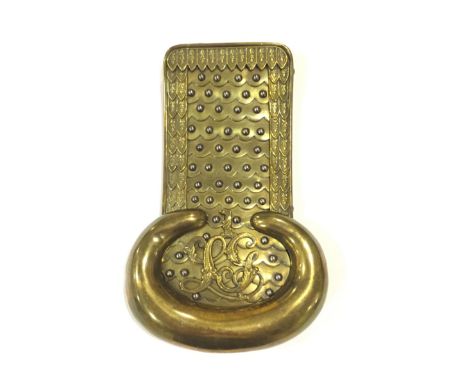
Lot 387
1st Life Guards early 19th Century Shoulder Scale. An exceedingly rare single example circa 1830. Gilt brass, the strap of simulated scales, each decorated with an oak leaf device. Within the crescent is mounted the title LG surmounted by a 1. The underside with scarlet cloth and lace attachment for the uniform. GC some mothing to the cloth underside.
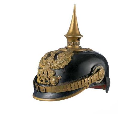
Lot 698
WW1 Prussian Officer’s Picklehaube & Cover. A good Officer’s Picklehaube with rounded front peak and gilt metal fittings. Prussian eagle plate to front and with circular spike base to the crown. State and national cockade with gilt chin scale strap. The interior retains a brown leather sweatband. The picklehaulbe is complete with fild grey cloth cover. This with the stamp “DRP.”. Overall condition is good, gilt duled to brass, small stitching fault to the rear peak, otherwise GC.#11;
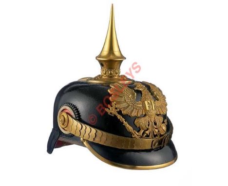
Lot 740
WW1 Prussian Officer’s Picklehaube. A good Officer’s Picklehaube with rounded front peak and gilt metal fittings. Prussian eagle plate to front and with circular spike base to the crown. State and national cockade with gilt chin scale strap. The interior retains a brown leather sweatband, with cream cotton lining. Very Good condition, retains a good shape.#11;
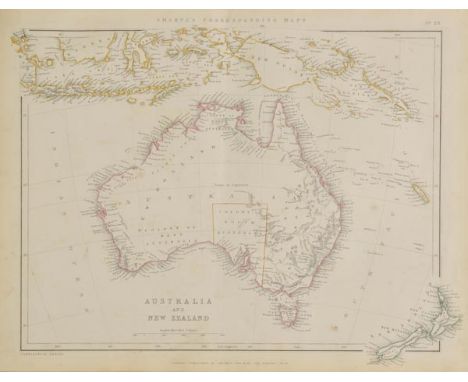
Lot 31
Sharpe (John). Sharpe's Corresponding Atlas, comprising fifty-four maps, Constructed upon a System of Scale and Proportion from the most Recent Authorities, engraved on Steel by Joseph Wilson Lowry, with a Copious Consulting Index, published Chapman & Hall, 1849, title, preface and contents page, fifty-four (complete) engraved maps with contemporary outline colouring, slight spotting throughout, ownership signature to front endpaper, some staining to preliminaries, contemporary half calf gilt with gilt calf label to upper siding, upper board detached, spine partially lacking, rubbed and worn, folio (1)
![Berkshire. Simmons (Matthew), Barkeshire with some consining Townes, [1625 or later], uncoloured map engraved by J Van Langer](https://cdn.globalauctionplatform.com/bf7f6b51-c0bb-47e6-bf07-a5b100f98eec/ff67b70a-290f-4b7b-d5bb-243565e13a0c/468x382.jpg)
Lot 86
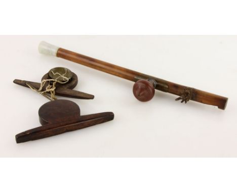
Berkshire. Simmons (Matthew), Barkeshire with some consining Townes, [1625 or later], uncoloured map engraved by J Van Langeren, some soiling, wear and slight loss to margins, strengthened on verso, 110 x 100 mm, together with, Van den Keere (Pieter), Connack Millaria Anglicana, circa 1627, hand coloured map, 85 x 120 mm, English text on verso, with, Gibson (John), Somersetshire, [1759], uncoloured engraved miniature map, 65 x 110 mm, plus, Belfast Ropework Company Ltd, Brass measuring scale, circa 1910, brass and wood sliding measuring scale, calibrated with the measurements for rope, wire, tared hemp and Manilla coils, 120 x 45 mm, with a pewter medal showing the two hemispheres of the world, diameter 50 mm, and, Jaques & Son Ltd (publishers), The Counties of England. A Geographical Game, 2nd. series, circa 1910, forty-eight (complete as key card) colour printed cards, contained in publisher's card slipcase with printed label to upper board, a little worn and frayed (6)
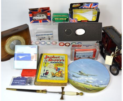
Lot 210
A collectors lot comprising Concord memorabilia to include scale model Concords, badges etc, a boxed limited edition Coalport plate commemorating the 50th anniversary of the battle of Britain 1940-1990, a boxed limited edition vintage model pressed steel car, a 1950s time savings clock, a decorative brass mounted dagger, Dinky scale model vehicle commemorating the silver jubilee of Elizabeth II, a copy of 'Japhet and Happy's Annual 1936' etc all contained within a suitcase.
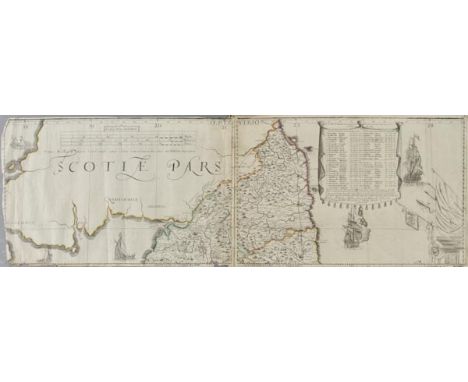
Lot 108
England & Wales. Lea (Philip), Untitled map taken from Christopher Saxton's large scale map of England and Wales first published in 1583, this state published Philip Lea, Globemaker at ye Atlas and Hercules in Cheapside nere the corner of Fryday Street in London, [1687 - 1700], engraved map with contemporary outline colouring on five sheets, with two additional loose sheets, bound in contemporary vellum with manuscript title 'Mappe of England' on outside of vellum and rolled presumably to facilitate ease of carriage when travelling, half compass rose, table of longitude and latitude of principal towns, some fraying to map strip margins, appears to be lacking two smaller portions (East coast of Norfolk & Suffolk and South West Cornwall), each sheet approximately 285 x 855 mm, two loose sheets approximately 280 x 200 mm R.W.SHirley. Early Printed Maps of the British Isles 1477 - 1650, no.137, state 5. Christopher Saxton published his twenty sheet wall map in 1583. It was re-issued by Cade & Morgan in 1678. Philip Lea aquired the copper plates in about 1685 and re-published the map on a smaller scale designed to be used as a travelling map. He reduced the map to ten full sheets and four half sheets and removed a great deal of the sea, thus making the map relevant to land based travellers. The map was pasted into five horizontal strips. The top three sheets made up of two sheets and the last two sheets made of two sheets with a half sheet pasted at each end. It appears that two of these half sheets are lacking from this example. Philip Lea re-engraved the plates at least five times during his perod of ownership. This example is his 5th and final state and therefore state 7 of a total of nine states. Lea moved from Poultry to Cheapside in 1687 and remained there until 1700. Following Lea's death, Anne his widow, re-engraved and re-issued the map with Richard Glynne in 1720 and Thomas & John Bowles & Son repeated this in 1758. Scarce. (1)
![Gloucestershire. Saxton (Christopher & Hole William), Glocestriae Comitatus olim sedes Dobunorum, [1610], hand coloured engra](https://cdn.globalauctionplatform.com/bf7f6b51-c0bb-47e6-bf07-a5b100f98eec/7f66a4bc-abee-4b54-a7c5-61846202843f/468x382.jpg)
Lot 116
Gloucestershire. Saxton (Christopher & Hole William), Glocestriae Comitatus olim sedes Dobunorum, [1610], hand coloured engraved map, elaborate strapwork cartouche and mileage scale, 285 x 320 mm, together with another five hand coloured engraved maps of Gloucestershire, with examples by Moll, Moule, Cary, Morden and Greenwood, various sizes and condition (6)
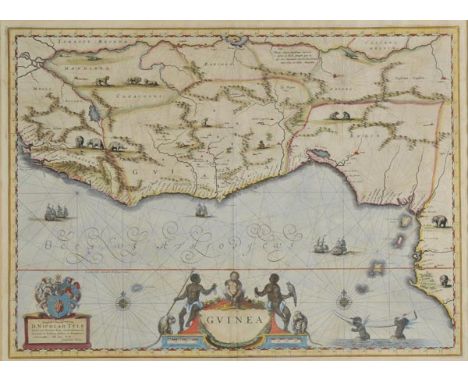
Lot 117
*Guinea. Blaeu (Willem J. Z.), Guinea, circa 1645, engraved map of West Africa with contemporary hand colouring, decorative cartouche and mileage scale, compass rose and numerous rhumb lines, one short crack along oxidised old colouring, 385 x 530 mm, Latin text on verso, mounted, framed and double glazed (1)
Lot 147
*Nottinghamshire. Jansson (Jan), Comitatus Nottinghamiensis sive Nottinghamshire, circa 1650, engraved map with contemporary hand colouring, ornate cartouche and mileage scale, 380 x 485 mm, mounted, framed and glazed, together with, Moule (Thomas), Leicestershire, circa 1848, hand coloured engraved map, 255 x 200 mm, framed and glazed (2)
Lot 161
*Scotland. Blaeu (Johannes & Pont Timothy), Coila Provincia. The Province of Kyle, circa 1665, engraved map with contemporary hand colouring, decorative cartouche and mileage scale, slight creasing, 455 x 565 mm, Dutch text on verso, mounted, framed and double glazed, together with, Morden (Robert), A New Map of the South Part of Scotland [1722], hand coloured engraved reticulated map, 355 x 440 mm, mounted, framed and glazed (2)
Lot 167
South America. Jansson (Jan), Guiana sive Amazonum Regio, circo 1645, uncoloured engraved map of part of North-east South America showing Trinidad and modern day Guyana, Suriname and French Guiana as well as the course of the River Amazon, elaborate cartouche and separate scale of distance, compass rose and rhumb lines, 380 x 495 mm, Latin text on verso, together with, Blaeu (William), Paraguay, O Prov. De Rio de la Plata cum regionibus adiacentibus Tucuman et Sta. Cruz de la Sienna, published Amsterdam, circa 1650, engraved map with contemporary outline colouring, ornate cartouche and central compass rose, 380 x 485 mm, Latin text on verso (2)
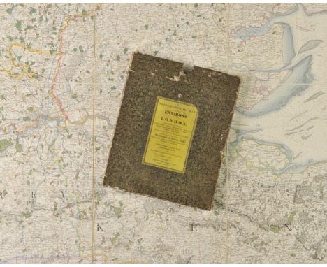
Lot 169
South East England. Cary (G. & J.), A Topgraphical Map of the Environs of London, comprehending the Counties of Middlesex, Essex, Hertford, Oxford, Buckingham, Berks, Hants, Surrey, Sussex and Kent, planned upon a scale of two miles to an inch on which are Described the whole of the Turnpike and Carriage Roads, particularly distinguishing the latter from the inferior Bye-Roads, also Towns, Villages, Rivers, Hills, Gentlemen's Seats and every object interesting to the Traveller or Resident, [title on slip case], published G. and J. Cary, 1822, large engraved map sectionalised and laid on linen, with contemporary outline colouring, marbled endpapers, 1460 x 1850 mm, contained in contemporary marbled card slicase with printed label to upper siding, worn and rubbed at extremities Uncommon. Not listed in Howgego. (1)


Lot 349
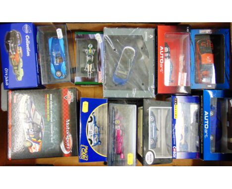
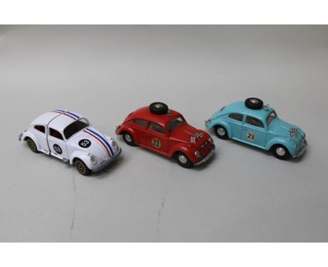
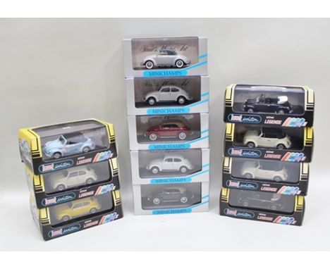
JOHNNY LIGHTENING HOLIDAY CLASSIC DIE-CAST VOLKSWAGEN BEETLE, NEW BEETLE AND SAMBA BUS in original vendor's box, snow scene feature, Minichamps model art 1:43 scale die-cast vehicles (4) in original vendor's boxes including two with split windows, on e 1200 cabriolet saloon model, together with New-Ray die-cast vehicles Volkswagen Beetle convertibles in original packaging, being five die-cast vehicle gift set, Roadsters Road Convoy set boxed and a Siku Super Series cabriolet on trailer with towi ng vehicle, boxed

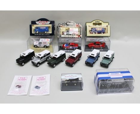
Lot 362
SIX DIE-CAST MODELS OF LANDROVER DEFENDER LWB STATION WAGONS, Oxford Road Show Bedford van in acrylic packaging, an Oxford Railways scale novelty van, two P and D Marsh model railways miniature VW's packaged, N gauge, lady's 280 GE Siku vehicle, Triu mph TR7 D8 Manx Rally 1978 and Porsche Carrera RSR, both in acrylic packaging, Days Gone Vanguard series Cinzano VW van, Kleenex Tissues truck and Days Gone Madame Tussauds VW van (16)
Lot 384
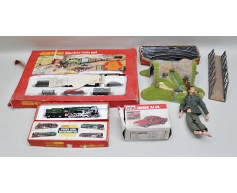
HORNBY RAILWAYS ELECTRIC TRAIN SET 00 gauge no.R541 freight set in original vendor's box (distressed) comprising; tank loco, six items of rolling stock, platform, quantity of track, bridge, a BR2-10-0 locomotive "Evening Star" no.R861 in original ven dor's box, Action Man, Polistil Jaguar XJ6L 1:25 scale in original vendor's box
-
216134 item(s)/page