

Nova Hispania, et Nova Galicia Decorative map of the central and western coastal regions of Mexico, based on Ortelius. Mexico City is situated on a large lake below the elaborate title cartouche featuring the Royal Spanish Arms. Several gold and silver mines are located in the central region. A galleon and sea monster ornament the Pacific and armadillos walk across the scale of miles cartouche. This is a superlative example of Dutch cartography and a great example of the similarity between the work of Jansson and Blaeu. Here Jansson`s plate features a ship and sea monster with calligraphy in the Pacific, whereas Blaeu`s map lacks the calligraphy and embellished the area with two ships and a compass rose. Latin text on verso. Expertly remargined on all sides with light toning along centerfold and a separation at bottom that has been professionally repaired. There are three tiny holes just inside border at top left, one of which has been infilled. 13.7 W x 18.9 H Jansson, Jan 1638
We found 186097 price guide item(s) matching your search
There are 186097 lots that match your search criteria. Subscribe now to get instant access to the full price guide service.
Click here to subscribe- List
- Grid
-
186097 item(s)/page

Carte de de l`Isle St. Christophe This lovely map of St. Kitts is fully engraved with mountains, rivers, lakes, and towns. The island has twelve quarters and parishes, which are sometimes indicated by hand coloring, but not on this example. In the center of the island a note on the mountain Mont Misery locates Mines de Souffre. Grande Saline, Ville de la Basse Terre, forts, churches and more are identified. Decorated with baroque-style title and scale of miles cartouches and a fleur-de-lys, all fully colored. A nice bright sheet with light offsetting. 7.5 W x 12 H Bellin, Jacques Nicolas 1763

America Australis A crisply engraved map of South America filled with towns and pictorial representations of the mountainous topography. Near Guyana, the fictitious lake of Parime is named with the mythical city of Dorado shown upon its shores. A number of ships sail the seas, and the map is decorated with a cartouche showing the bounty of South America, including fat-tailed sheep. The scale of miles is topped with the symbol for the Society of Jesus. Heinrich Scherer, professor of mathematics at Munich, was a devout Jesuit. Many of the maps and plates in his atlas emphasize the Catholic hierarchy and the spread of Jesuit missions throughout the world. A bright, clean example with a dark impression and a tiny hole in southern South America. 9.1 W x 14.1 H Scherer, Heinrich 1699

Tabula Magellanica, qua Tierrae del Fuego, cum Celeberrimis Fretis a F. Magellano et I. Le Maire Detectis Novissima et Accuratissima Descriptio Exhibetur This is one of the most elaborately decorated maps to focus on the tip of South America with the Strait of Magellan and Le Maire Strait. The coastlines are depicted as very mountainous, while the interior is completely without detail. Instead the region is filled with a hunting scene, exotic birds including rheas and penguins, and a quaint scene of village life. The map is further adorned with a pair of compass roses, three sailing ships, and four beautiful cartouches. The key to the map is in a strapwork cartouche held aloft by putti, while the dedication cartouche at right is left blank. The cartouches arrayed across the bottom of the map present a unique distance scale in checkerboard format and the title with a tribe of Fuegian natives, penguins and shells. This is the first state with a blank verso. A dark impression with minor printer`s ink residue and a small, professionally repaired hole in border below penguins, with border expertly replaced in facsimile. 16.1 W x 20.8 H Jansson, Jan 1646

Tabula Islandiae Auctore Georgio Carolo Flandro This handsome copper engraved map of Iceland was based on information from a Dutch navigator named Joris Carolus in about 1620. The map shows the influence of both versions of Bishop Gudbrandur`s previous maps, a coastline resembling the Ortelius version, and Mercator`s selection and spelling of many place names. The island`s topography is dominated by huge mountains and volcanoes and its shoreline is a rugged labyrinth of fiords. It is richly embellished with title and distance scale cartouches, compass roses, rhumb lines, a sailing ship and two sea monsters. The cartouche features two winged sprites, an important symbol in Icelandic and Norse mythology. Along with elves and dwarves, sprites were magical beings who aided the gods. The map was first issued by Jodocus Hondius and then re-issued by Willem Blaeu with his imprint. It became the prototype for the mapping of Iceland and its influence did not wane until the mid-18th century. French text on verso, published between 1643-50. A fine impression with original color that has been partially refreshed and minor damp stains in the bottom blank margin. 15 W x 19.5 H Hondius/Blaeu, 1644

Anglia Regnum This fine map of England and Wales was copied from Willem Blaeu`s map and its decorations are nearly identical except that Jansson has added heraldic shields in Scotland and Ireland. It is decorated with four ships, a scale of miles flanked by sheep and a cherub, and two finely engraved coats of arms, of Great Britain and of England, surmounting the title cartouche. French text on the verso, published between 1645-46. A bright example with a fine impression, minor show-through of text on verso, and a professionally repaired 1"" tear in Glamorganshire. 15.3 W x 19.8 H Jansson, Jan 1645
![[Lot of 3] Suecia et Norvegia ect. [and] Gotia [and] Thietmarsia This matched set of 3 miniature maps are from Bertius` geog](http://lot-images.atgmedia.com/SR/36385/2906594/455-20145813754_468x382.jpg)
[Lot of 3] Suecia et Norvegia ect. [and] Gotia [and] Thietmarsia This matched set of 3 miniature maps are from Bertius` geographical treatise. Each map is beautifully engraved with a strapwork title cartouche and distance scale. The majority of the maps for Bertius` geographical treatise were engraved by Jodocus Hondius Jr. after Mercator. French text on verso. Size varies slightly.A. Suecia et Norvegia ect. This map depicts Scandinavia, extending east to include parts of present-day Russia and the Baltic states.B. Gotia. A lovely miniature map of southern Sweden delineating Gotland, Oland and the mainland from Stockholm south to below Vaxjo.C. Thietmarsia. This map shows the Holstein region in northern Germany, between the Eider and Elbe Rivers. The map is oriented with north to the left and features a moire-patterned sea. Very light toning, minor show-through of text on verso, and marginal soiling. 3.8 W x 5.3 H Hondius/Bertius, 1616

Fionia Vulgo Funen Fine map of Fyn, Langeland and Als decorated with two distinctive cartouches, fancy scroll calligraphy and sailing ships. A large coat of arms is at upper left and the title cartouche featuring farmers and cows is at lower left. At right is a second cartouche containing a distance scale in an unusual vertical format. French text on verso, published between 1643-50. A nice impression on watermarked paper with original color that has been partially refreshed. There is light toning and minor damp stains confined to the bottom blank margin. 15 W x 19.6 H Blaeu, (Family) 1643

Groningae et Omlandiae Dominium Vulgo de Pronvincie van Stadt en Lande... This detailed map of the northern Dutch region of Groningen extends to Emden. It is filled with meticulously engraved detail of the towns, roads, landmarks and topography. The scale of miles in the lower left is graced with coats of arms, allegorical figures and a putto bearing a lyre. The map is dedicated to D. Ludolpho Tjardae of Starkenburg. Lovely original color that has been partially refreshed, light soiling, and faint damp stains that enter 1"" to 2"" into map at right and left. 18.4 W x 22.4 H Visscher, Nicolas 1680
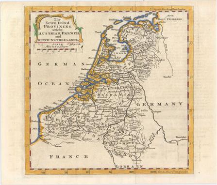
The Seven United Provinces, with the Austrian, French, and Dutch Netherlands This excellent small map of the Low Countries extends to show parts of Germany and France, which are left largely unengraved. Many cities are shown, including Amsterdam, Utrecht, the Hague, Antwerp, and Brussels, as are several provinces, rivers, and roads. A decorative title cartouche and enclosed distance scale adorn the top left corner of the map. Issued folding with some minor offsetting from an opposing page of text. 7.2 W x 7.1 H Jefferys, Thomas 1760

Hispaniae Nova et Exacta Descriptio This very rare map of Spain and Portugal was published only in the first edition of Paulus Merula`s Cosmographiae Generalis, which included 5 larger maps engraved by Johannes and Baptista van Doetecum and 38 maps from Petrus Bertius` Tabularum Geographicarum. The map extends to the Balearic Islands and the northern tip of Africa, and is filled with details of towns, rivers, mountains, and political boundaries. Elegantly engraved by Baptista van Doetecum, the map is embellished with a compass rose, sailing ship, and delicately patterned sea. The strapwork title cartouche encompasses the distance scale and is topped with the Royal coat of arms of Spain, ruled by the House of Habsburg.Merula, a Dutch jurist, was appointed to the chair of history at the University of Leyden in 1592. In addition to this geography he also published folio editions, wrote many treatises on laws and history, and is also known for his geological studies. A fine impression with attractive color on watermarked paper. Issued folding, now pressed, with minor offsetting and a binding trim at left that has been professionally repaired. 9.2 W x 12.8 H Merula, Paulus G. 1605

Marchionatus Brandenburgi et Ducatus Pomeraniae Tabula quae est Pars Septentrionalis Circuli Saxoniae Superioris A handsome and detailed map of the historical regions of Brandenburg and Pomerania, straddling the modern-day border between Germany and Poland. The map is fully engraved with towns, political boundaries, rivers, and forests. The map is embellished with a title cartouche floating in the clouds with putti and coats of arms, and a distance scale featuring bee hives and a field of wheat. Attractive original color that has been partially refreshed, light soiling, a small abrasion and archival paper repairs along centerfold at bottom, and a faint damp stain that just enters map border at left. 19.4 W x 22.4 H Wit, Frederick de 1680

Polonia Regnum, et Silesia Ducatus This splendid map of the PolishLithuanian Commonwealth extends just past Lublin in the east and Krakow in the south. There is excellent detail of towns, rivers, and forested areas. The map is handsomely adorned with an allegorical title cartouche, the coat of arms of Poland held aloft by putti, and a distance scale surrounded by putti and the coat of arms of Silesia. French text on verso, published between 1643-50. A nice impression with original color that has been partially refreshed, light printer`s ink residue, two printer`s creases adjacent to centerfold, and faint damp stains in bottom blank margin. 16.5 W x 20.3 H Blaeu, Willem 1643
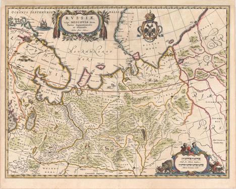
Russiae, Vulgo Moscovia Dictae, Partes Septentrionalis et Orientalis. Auctore Isaaco Massa This map is based on the travels of Isaac Massa, who visited Moscow in the early 1600s. It details the area from Finland to Siberia and beyond the Jenisej River and south to the Volga River, with Kazan and Novogorod shown. A partial coastline of Novaya Zemla is shown at the top of the map. The map is fully engraved with mountains and forests with deer, bear and other animals throughout. The title cartouche is flanked with pelts, and hunters and a wide variety of animals surround the scale of miles. The crest of the Russian Empire is shown at top. The map is nearly identical to Jansson`s map of the same title. Johannes and Cornelius Blaeu`s imprint appears above the distance scale. Latin text on verso, published between 1640-43. A fine impression on watermarked paper with original color that has been partially refreshed. There are some faint stains at top near title cartouche, and the map has been professionally remargined at top. 16.6 W x 21.5 H Blaeu, (Family) 1640

Taurica Chersonesus, Nostra Aetate Przecopsca, et Gazara Dicitur Attractive map of the region north of the Black Sea based on Mercator with the toponym from medieval portolan charts. The map covers the region from Moscow in the north to the Black Sea and from the mouth of the Danube to approximately Sochi in the east. The interior is filled with large forests and mountains with little information on settlements except along the rivers. It is embellished with small strapwork title and scale of miles cartouches and three ships. French text on verso. A nice impression on watermarked paper with old color that has been partially refreshed. There are some faint damp stains in bottom blank margin that enter map border in a few spots. 15.1 W x 19.8 H Blaeu, (Family) 1643

Transsylvania XXI Nova Tabula This attractive woodblock map covers the region of present-day Romania that was then the heartland of the Saxon community in southern Transylvania. The map graphically depicts the mountains, rivers and forests and locates numerous towns. A large distance scale is at bottom and the title is in the top margin. This map only appears in a few editions of Munster`s Cosmographia, and is therefore uncommon. Latin text with a lovely woodcut engraving on verso. Excellent impression and color with a professionally repaired tear that enters 1"" into image at bottom right. A chip in bottom blank margin along centerfold has been repaired with old paper. 10.5 W x 13.4 H Munster, Sebastian 1562

Walachia Servia, Bulgaria, Romania This attractive map of the Eastern Balkans is centered on Bulgaria and includes the Bosphorus and Constantinople. The Danube and its tributaries flow across the map and are the focal point. It is adorned with a strapwork title cartouche and a unique block-style distance scale in the opposite corner. French text on verso, published between 1628-33. A nice impression on watermarked paper with full margins and a few minor extraneous creases. 13.7 W x 18.5 H Mercator/Hondius, 1628

Tabula Geographica, in Qua Omnes Regiones, Urbes, Oppida, et Loca Describuntur, quorum mentio sit in Actis et Epistolis Apostolorum, et Apaocalypsi This superb, graphic map of the eastern Mediterranean, from Rome to Babylon, depicts the spread of Christianity as reported in the Acts of the Apostles. This is the final map of the standard set of five Holy Land maps normally found in Dutch Bibles. The map is surrounded by fifteen Biblical vignettes including the apostles receiving heavenly inspiration, and the events of the Apocalypse as in the book of Revelations. The map includes a small inset of the whole Mediterranean region and is further decorated with a compass rose, sailing ship and strapwork distance scale. This is the second state with Plancius` name in the cartouche replaced by D.R.M. Mathes. Dutch text on verso, from a Dutch Bible published by Cloppenburg. This is the second series of Dutch bible maps by Petrus Plancius, first published in 1604 by Johannes Cloppenburg. The first series consisted of a world map and 4 small maps of the Holy Land and Middle East, engraved by Johannes van Deutecum and his two sons, Johannes and Baptista. After Johannes van Deutecum (the younger) published a new set of maps in 1595, Plancius realized that his own maps required updating. He commissioned Baptista van Deutecum to engrave the second series, who also enlisted the assistance of engravers Daniel van Bremden and Pieter Bast. Plancius` second series retained the same world map and 6 larger, re-engraved maps of the Holy Land and Middle East. The purpose of the maps was to help explain the biblical texts, but Plancius decided to take the maps one step further by adding 15 biblical vignettes surrounding each map, thereby transforming each map into a work of art. Issued folding, now pressed with a 3"" tear adjacent to centerfold near bottom that has been professionally repaired. Remargined at both sides to accommodate framing. 11.3 W x 19.3 H Plancius/Cloppenburg, 1643

Nova Persiae Armeniae Natoliae et Arabiae This splendid map of the Middle East covers the region from Turkey and Egypt to Afghanistan with the Arabian peninsula prominently shown. The detail in Arabia is based on Sanson`s map of 1654, one of the largest scaled and best detailed maps of the region until the mid-seventeenth century. The decorative title cartouche features several exotic figures, animals and a merchant ship. A mapmaker works atop the scale of miles cartouche using dividers and other tools of the trade. A fine impression with original color that has been partially refreshed and a professionally repaired tear that enters 3"" into map at bottom. There is a manuscript title in French in the top blank margin. 18.8 W x 22.1 H Wit, Frederick de 1680

Natolia, quae olim Asia Minor This handsome map of present-day Turkey includes several Aegean Islands and Cyprus prominently shown in the south. A fierce sea battle rages in the Mediterranean along with curious looking sea monsters. Two winged female creatures suspend the banner style title cartouche, and the map is further decorated with an unusual vertical scale of miles. Spanish text on verso, published between 1653-66. A fine impression with very light soiling and a few professional repairs along the centerfold. 15.1 W x 19.7 H Jansson, Jan 1653

La Romelie et les Environs de Constantinople Attractive map of Turkey centered on Istanbul that covers the region from Sophia to Kutahya with good detail of topographical features and the river system. The map is adorned by three sailing ships and a distance scale above the imprint. A dark impression with light scattered foxing and a damp stain that just passes the border at top. 17.1 W x 21.9 H Santini, P. 1778

Het Beloofde Landt Canaan door Wandelt van Onsen Salichmaecker Iesu Christo, Nessens Syne Apostelen Graphic map of Israel filled with biblical scenes. A compass rose orients the map with north in the top right corner. The large decorative title cartouche at bottom is flanked with the four evangelists and vignettes depicting the life of Christ, including his birth, crucifixion and resurrection. At top, putti hold banners with the key to the map and scale of miles, and tiny ships and the track of Apostle Paul are shown in the sea. Published by Hendrik and Jacob Keur in a Dutch Bible, with Dutch text on verso. A fine impression, issued folding, now pressed, with minor printer`s ink residue at top center and a few minor fold separations confined to blank margins. 14 W x 18.3 H Stoopendaal, Bastiaan 1686

Het Beloofde Landt Canaan, door Wandelt van Onsen Salichmaaker Iesu Christo, Nessens Syne Apostelen Very graphic map from a Dutch Bible depicting the land of Canaan with north oriented to right. The map is based on Nicolas Visscher`s map of 1657, but the decorative elements are completely original. The large decorative title cartouche features allegorical figures at the bottom representing strife and death, and at top the promise of everlasting life. Two insets flanking the title depict the Christ`s Birth and Crucifixion. At top, putti hold banners with the key to the map and a scale of mile, and tiny ships sail in the sea. Dutch text on verso. Issued folding, now pressed with a small paper flaw at far right, an insignificant spot in title cartouche, and several professionally repaired fold separations confined to blank margins. 13.8 W x 17.8 H Avelen, Jan van den 1687

Karte von den Eylanden in der Mundung des Flusses Canton nach den Wahrnehmungen der Schiffahrer This is the German version of this map centered on the mouth of the Pearl River, here called the Canton. The map features nice detail of the islands off the coast of Southeastern China including part of Macao. There are numerous soundings noted as well as a large compass rose, fleur-de-lis, rhumb lines and decorative title cartouche with distance scale. Issued folding. 8.1 W x 12.5 H Bellin, Jacques Nicolas 1754

Les Vrays Indes dits Grands Indes ou Indes Orientales An attractive small map covering the region from India east to Thailand and the Malay peninsula, north to China. The map is filled with towns and villages along the coastline, rivers and topography. Adorned by a decorative drape-style title cartouche and distance scale. Engraved by Charles Inselin. Lightly toned with minor offsetting along the centerfold. 9 W x 12.4 H Fer, Nicolas de 1705

Africa A reduced version of Hondius` superb map of the continent. It is based on the Mercator model with revisions to the coastlines, particularly that of Madagascar. Hondius improved the Cape area by inserting C. Falco and discarding Cayneca. In western Africa, the Niger River flows in a fairly straight line to the Atlantic, and two large lakes south of the equator are shown as the source of the Nile River. The map is crisply engraved and decorated with strapwork title and distance scale cartouches. Latin title page on verso, published in the first edition. Light, overall toning. 3.8 W x 5.3 H Hondius/Bertius, 1616

L`Afrique Divisee Suivant l`Estendue de ses Principales Parties Gerard Valck was granted privilege to produce maps copied from Sanson/Jaillot in late 1695 and issued this map of Africa along with the other continents and the world to appeal to increasing demands in the French market for maps with French text. The map shows details typical of the late seventeenth century. The large rivers are marked and the Nile appears according to the ancient pattern, arising from two lakes located south of the equator. No tribal names appear in the south other than the Monomotapa kingdom. There are two islands of St. Helena, as so often appear in maps of this period. The title cartouche in the upper right corner consists of two cherubs holding a fringed blanket on which the title appears. At the lower left corner is a distance scale cartouche featuring a lion, an elephant, a leopard, a camel and a crocodile. An additional French title is in the top margin. A nice impression with original color, light soiling, a 1"" edge tear at bottom closed on verso with archival tape, and two small worm holes in unengraved areas of map. 18.4 W x 22.8 H Valck, Gerard 1696


Good English transitional fruitwood double fusee verge bracket clock, the movement with engraved back plate signed Hamley, Warwick Place, London with pull/repeat and striking on a bell, bearing a Camerer Cuss plaque to the inside of the door, the 6.75" cream dial signed Hamley, Warwick Place, London above fish scale fret panels, within a pad top stepped case with moulded arched cornice and brass carrying handle, 15" high (a.f) (pendulum)


▲ William Mitchell: A GRP mural of the London to Brighton Veteran Car Run depicting a vintage car race 1970`s in four sections each panel measures 167cm.; 66in high by 122cm.; 48ins wide, overall width 488cm.; 192ins Divided into four panels modelled in high relief with various well known landmarks on the London to Brighton Veteran car Run, including St Pauls Cathedral, Nelsons column, the newly built Post Office Tower, opened in 1965, The Albert Memorial, and Brighton Pavilion, together with various vintage cars. William George Mitchell (b1925) is an English sculptor, artist and designer. From the 1950s, Mitchell produced work for a wide variety of clients. His initial appointment at the London County Council (LCC) allowed him to set up his own company in the early 1960s, a company which at one point employed over 40 skilled craftsmen and artists. Mitchell`s interest in experimentation, during the 1960`s and 70`s resulted in a wide range of projects including the use of contemporary construction materials such as GRP (Glass reinforced plastic) and GRC (Glass reinforced concrete) to create large scale panelled installations as in this example. In the 1980s Mitchell went to work in Qatar for the Royal Families designing and building both the Qatar Zoo and the extensive Doha Corniche waterfront promenade. He also worked for the BART (Bay Area Rapid Transit) in San Francisco, USA where he was responsible for designing and constructing many of the decorative panelling and sculptural installations at a number of stations across the system. The 1980s also saw Mitchell in Honolulu, Hawaii where he created the modelled surroundings of the Civic Square. Mitchell spent many years as artistic design adviser to Mohammed Al Fayed and was responsible for the overall design and for the carving and modelling of the panels for the Egyptian Hall and the Egyptian escalator at Harrods. Mitchell has been a member of the Design Advisory Board, Hammersmith College of Art, Trent Polytechnic, Formwork Advisory Committee and the Concrete Society, and is a regular on the construction lecture circuit, both in his home country and abroad (especially the USA), being described as a |Doyen of British muralists| at a presentation he gave in 2007 to the Tile and Ceramics Society. After long years of neglect, many of William Mitchell`s remaining works in the United Kingdom are now being recognised for their artistic merit and contemporary historic value, and many have been granted protected listed status.

† ▲Beverly Pepper Untitled Black/rust Zimbabwe marble 300cm.; 118ins by 160cm.; 63ins Provenance: Acquired from the artist by the present owner Beyond Limits: Sotheby`s at Chatsworth - A Private Sale Offering Beverley Pepper began her artistic career as a painter, studying with Modernist luminaries such as Fernand Léger and Andre Lhote in Paris in the early 1950s. In 1960 she turned her attention to sculpture, and began to create large scale sculptures made out of industrial metals. The work exhibited at Chatsworth, Untitled, is typical of her more recent work, constructed from large slabs of stone. The triangular hole in the stone both reveals the inherent character of the stone and creates a triangular `altar` at the heart of the stone monolith giving the work the feel of a primitive totem. Beverly Pepper was born in Brooklyn in 1922 and has divided her time between homes and studios in New York City and Todi, Italy, cince 1951. Her work has been a the subject of one person exhibitions at The Metropolitan Museum of Art and the Brooklyn Museum of Art, and is well-represented in major public and private collections worldwide.


A pair of Royal Worcester cabinet cups and saucers from the Samuel Astles English Flowers Series together with a further Royal Worcester cabinet cup and saucer in the Scale Blue pattern, a Royal Crown Derby cup and saucer with turquoise and gilt decoration and three boxed Royal Worcester royal commemorative trinket boxes


Hornby boxed Limited Edition OO Gauge Scale Model `The Mid-day Scot`, with certificate of authentication No 1098/2000. Box contains Stanier Duchess Class Locomotive `46248 City of Leeds`, and 2 BR Mk1 Composite Coaches and one Mk1 Brake Coach. Never out of box so in mint condition, box very slightly rubbed.

Poster BR `Northern Ireland - The Giants Causeway` by Lander, double royal size 40" x 25". Dramatic view of the Amphitheatre with a small rowing boat in the foreground completely dwarfed by the sheer scale of the Causeway. Published by the Railway Executive London Midland Region, printed by Waterlow. Fold and some tape marks mostly around the edge but impinging the image in places.

Hornby boxed OO Gauge Scale Model `Lakes Express`, with certificate of authentication No 1265/1500. Box contains Stanier Duchess Class Locomotive `46221 Queen Elizabeth` with one BR Mk1 Composite Coach and 2 BR Mk1 Brake Coaches. Still in original wrappers never taken out of box so absolutely mint. Box slightly rubbed.

Hornby boxed OO Gauge Scale Model `The Silver Jubilee`, with certificate of authentication No 1910/2000. Box contains LNER A4 Class Locomotive `Quicksilver`, 2 Silver Jubilee Coaches and one Silver Jubilee Brake Coach. Never out of box so in mint condition. In a separate non original box are 3 more matching Coaches also in mint condition.


Scarce Henry Cotton Golf Board Game in makers original box c. 1938 – titled “Henry Cotton Invites you to “Tee-Up” for A Round of Golf” played over the Walton Heath Golf Course – comes with 18 hand painted detail cards of each hole at Walton Heath GC – all to scale and back to back, together with the Rules and Key to Fairways and Hazards, two yardage markers – may be incomplete but importantly it shows all the holes in detail and to scale – box measures 19 x 9.5”
-
186097 item(s)/page