We found 216134 price guide item(s) matching your search
There are 216134 lots that match your search criteria. Subscribe now to get instant access to the full price guide service.
Click here to subscribe- List
- Grid
-
216134 item(s)/page


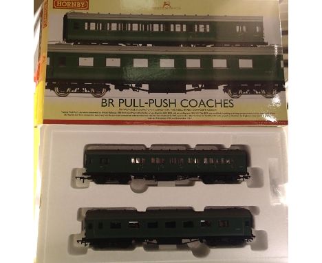
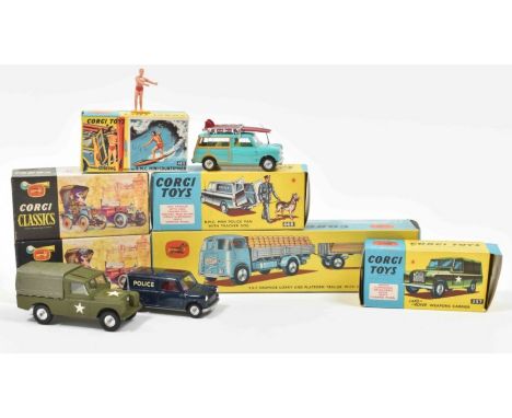
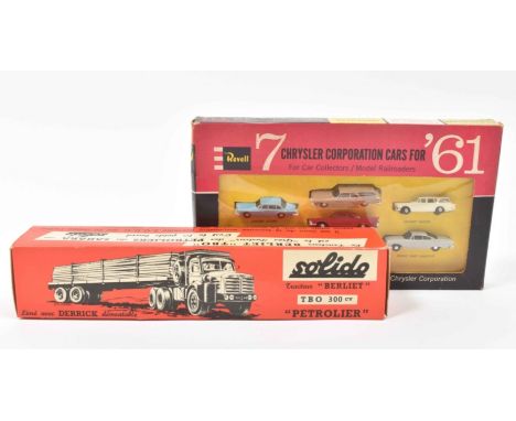
Lot 2501
Die-Cast scale model, Corgi, Playcraft Toys, London, 1964. (2) Landrover Wepons Carrier, Corgi Toys 357. (3) B.M.Mini-Countryman. W. opening doors. Plated Roof Rack. Surfing Figure. Surf Boards. Corgi Toys 485. (4) E.R.F. Dropside Lorry and Platform trailer w. cement and plank loads. Corgi Toys Gift Set no. 11. (Trailer only, lacking the Lorry)Added: Two Corgi Classics: 1915 Ford. No. 9011 and 1910 Renault Primrose No. 9032. *All boxed and in mint condition. (total 6)
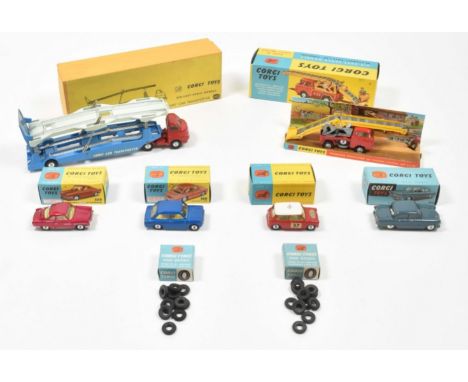
Lot 2503
Die-cast scale model. Corgi, ca. 1964. (2) Die-Cast "Carrimore" Car Transporter 1101. (3) Monte Carlo B.M.C. Mini-Cooper 317. (4) NSU Prinz 316. (5) Hillman IMP 251. (6) R.A.F. Staff Car-Standard Vanguard 352.Added: 2 boxes 'Corgi Tyres One Dozen'. *All boxed and in mint condition. (total 8)
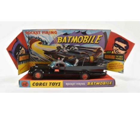
Lot 1300
Corgy Toys Die-Cast Scale Model, London, 1966. Sealed secret instructions concealed in box base. 12 red spare rockets attached to sprue. Pictorial card box with diaroma. Sublime copy, boxed and as new. *This copy had never been unpacked before and has been stored in the owner's attic for over 50 years.
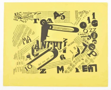
Lot 1892
Letterpress and cliché print, leaf size 32 x 39 cm (leaf), printed in black on bright yellow paper w. stamp "prova" in black verso.With central vertical fold; a bit creased in margins, but a very good copy. Eventually published in Let mots en liberté futuristes (Milan, 1919). 'A Tumultuous Assembly: Numerical Sensibility' is an example of tavole parolibere (free-word pictures). In this print, the subject of which is Italy’s victory in World War I, Marinetti drew from a visual collage and parole in libertà (words-in-freedom) and eschewed regulations of grammar and syntax to create a work that can be interpreted both visually and aurally. The work liberates numbers, signs, letters, and images from their functional responsibilities, exaggerates forms, and juxtaposes diverse elements, thereby producing unexpected associations. The Futurists celebrated the potential of war, drawing analogies between weaponry, such as torpedoes and bombs, and Futurist poetry. Here, Marinetti combined innovative typography, found elements (such as the image of the drummer boy on the left and the strips of letters and numbers throughout the composition), and dramatic variations in scale to create a dynamic composition representing a celebrating crowd'. (www.metmuseum.org)
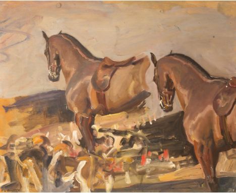
Lot 5
Sir Alfred James Munnings, PRA, RI (1878-1959)/Study For A Horse/signed AJ Munnings lower left/inscribed verso 'study for a horse on left in Why weren't you out yesterday'/oil on board, 48.25cm x 59.5cm/Provenance: An Important Collection of Sporting Pictures sold by order of Messrs. Hutchinson & Co. (Publishers) Limited; Christies, London, 20 July 1951, lot 40 (sold for £105) H.B. Hill, Esq., Gloucester/Exhibited: London, Royal Academy of Arts, Diploma Gallery, 1956, no.45/Note: A preparatory study for 'Why weren't you out yesterday', which was exhibited at the Royal Academy in 1939, five years before Munnings was elected President. One of Munnings' most humorous works (and featuring his wife, Violet, a family-friend, and four of his own horses), 'Why weren't you out yesterday' was based on a portrait of Mrs Cutting and her daughters, members of a prominent New Jersey family, painted in 1935. Munnings said 'so taken I was with the arrangement that I repeated almost the same design on another canvas for my own amusement'. In preparation for larger scale paintings, Munnings would produce studies to test, and figure out elements of each composition. The present work shows the artist doing exactly this, which affords the viewer an insight into his creative process. It is likely that Munnings would have painted the central hunter first, as the one to the right is a more worked-up version, with re-considered elements such as the angle of the head, and twitch of the left ear (communicating the horse's state of alert), both of which feature in the final painting. The hounds have been created with a quick succession of brush strokes that capture the energy and movement of the pack: light brown insinuates heads and rumps, and dashes of white create wagging tails. The red from the huntsmen's jackets beyond, breaks up the composition, a device which John Constable, a fellow Suffolk artist much admired by Munnings, also employed, particularly in his landscapes. The grey beyond strengthens the silhouettes and forms of the hunter and is a colour test for the sky of the final composition. It has been speedily executed with a gradation of colours and a 'zigzag' to the left, giving the implication of a cloud formation. Spontaneity, immediacy, understanding and above all, enjoyment are apparent in this study, and it captures Munnings returning, as he did throughout his life, to two of his greatest passions: horses and hunting. Our thanks go to Tom Rooth for producing this catalogue note CONDITION REPORT: The overall condition of the paint surface looks good. There are some minor flecks and specks of dirt as well as a couple of faint scuffs. The paint surface does look a bit dry and it would benefit enormously form a varnish. The frame has several knocks and surface flakes, I do not think the frame does the painting any favours. The board has a few worm holes to the reverse, these do not appear to the paint surface. I would say this painting has been very little interfered with and it could benefit form a little attention.ARR Artist's Resale Right may apply to the sale of this lot if the hammer price is the equivalent of 1000 Euros or more, incurring an additional fee. For further information please ask Chorley's or visit www.dacs.org.uk
Lot 111
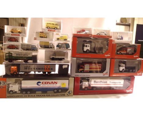
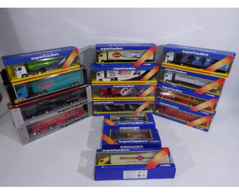
Corgi - Fifteen boxed diecast 1:64 scale Corgi 'Superhaulers' trucks. Lot includes TY87006 DAF 95 SWB & Close Couple Trailer 'Pickfords'; TY86617 Scania Curtainside 'Prestons of Potto'; TY86626 Scania Curtainside 'James Irlam' and similar. Models appear Excellent - Mint in window boxes ranging Fair Plus - Good with general storage wear and imperfections. (This does not constitute a guarantee)
Lot 113
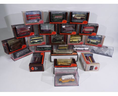
EFE, Corgi Original Omnibus - 22 boxed diecast 1:76 scale model buses. Lot includes EFE #12115 Harrington Cavalier 'South Wales NBC'; Corgi OO #42721 Van Hool Alizee 'W.Robinson'; EFE #14101 Bristol Lodekka 'United and similar. Models appear Very Good - Mint, in window boxes ranging some Poor - mainly Fair Plus - Good with storage imperfections. Some models loose in box, and are all unchecked for completeness. (This does not constitute a guarantee)
Lot 117
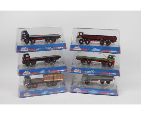
Corgi - Six boxed diecast 1:50 scale model trucks from the Corgi 'Marques of Distinction' series. Lot includes CC11509 AEC MkV 8 Wheeler 'William Nuttal'; CC10506 ERF KV 8 Wheel Dropside 'Rileys Transpiort'; CC10603 Leyland octopus 'Edward Derbyshire' and similar. Models appear to be in Excellent condition overall showing dusty signs of display, housed loosely in opened boxes, generally Fair with storage wear imperfections. Models are unchecked for completeness. (6 ) (This does not constitute a guarantee)

Lot 120
Corgi Heavy Haulage - A boxed 1:50 scale Corgi Heavy Haulage CC13209 Limited Edition DAF XF Ballasted Tractor, Nicolas Bogies & Load 'TSL Vanguard (Heavy Haulage) Ltd.' The model shows dusty signs of display and appears to be missing a certificate, otherwise appears Very Good - Excellent overall, unchecked for completeness. (This does not constitute a guarantee)
Lot 129
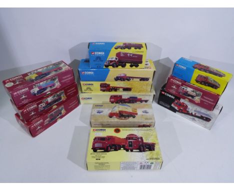
Corgi - A fleet of 12 boxed diecast 1:50 scale model trucks. Lot includes Corgi #29201 Guy Warrior Platform Trailer 'BRS'; #22101 Leyland Ergomatic Trailer Set 'BRS'; #20301 Bedford S Platform Trailer & Railway Container 'British Rail' and similar. Conditions appear to range Very Good - Mint, with majority of models showing dusty signs of display wear, presented in a couple Poor - mainly Fair Plus boxes with age and storage imperfections. (This does not constitute a guarantee)
Lot 148
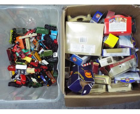
Corgi, Lledo, Oxford Diecast, Others - A large unboxed quantity of diecast in various scales. Lot includes Corgi Diamond T 980 Cab 'Wynns'; Lledo Morris Z Van 'Castrol'; Oxford Diecast 1:43 scale Commer Van 'PTO'; Corgi Thames Trader 'Chipperfields' and similar. Models all in Playworn condition ranging Fair - Very Good. Lot also comes with a large quantity of EMPTY diecast model boxes which be unassociated or associated with lot - condition generally Poor - Fair. All items are unchecked for completeness. (2) (This does not constitute a guarantee)
Lot 164
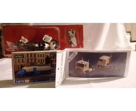
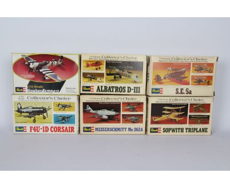
Revell - A squadron of six boxed 1:72 scale plastic model military aircraft kits by Revell. Lot includes Revell H61 F4U-1D Corsair; H75 'Collectors Choice' Sopwith Triplane; H76 'Collectors Choice' Messerschmitt Me262A and similar. Kits appear to be in Mint condition with loose parts and parts on sprues (some in clear open plastic bags), and all come with instructions and decals. All kits are unchecked for completeness. Kits are housed in Good - Very Good boxes with some age and storage related wear. (This does not constitute a guarantee)
-
216134 item(s)/page