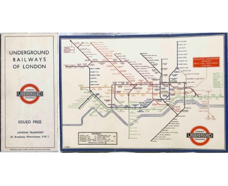
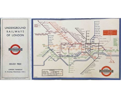
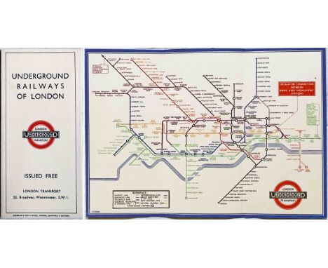
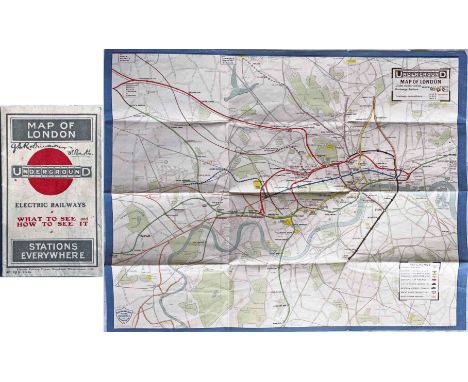
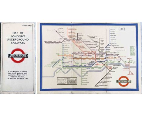
1913 London Underground POCKET MAP 'What to See & How to See it. Stations everywhere' with print-code 487-150M-1.6.13. Opens out to 14 " x 11" (36cm x 28cm). Shows projected extensions to Ealing Broadway, Queens Park and Edgware as well as the LNWR line to Watford in anticipation of the proposed Bakerloo extension. Cover has one of the first printed 'bar & circle' logos, possibly the first such. An excellent example in very good condition indeed with no significant blemishes other than (the first?) owner's name on the cover. [1]
We found 314796 price guide item(s) matching your search
There are 314796 lots that match your search criteria. Subscribe now to get instant access to the full price guide service.
Click here to subscribe- List
- Grid
-
314796 item(s)/page
c1932 Metropolitan Railway POCKET MAP, the Met's version of the London Underground map, with its own lines in red and the rest of the system in light blue. This is the green-cover issue with print-code M.1495/100M (no other codes), undated but circa 1932 and shows the Stanmore branch & Piccadilly Line to Cockfosters under construction. Generally in very good, lightly-used condition with light wear. [1]
London Transport pre-decimal GIBSON TICKET MACHINE s/n 27730 with correct case, webbing harness and plenty of spare rolls. This machine was professionally overhauled and restored by a specialist to mid-1950s condition a few years ago and prints fares from 1d-11d plus 'A' for Workman Returns. It incorporates a new fare print-wheel re-manufactured to original spec plus appropriate fare-band. One of only two to be treated to this very expensive restoration. Some wear to original, un-replaced print-plates but generally in good working order. [1]
c1924 Metropolitan Railway POCKET MAP, the Met's version of the London Underground map, with its own lines in red and the rest of the system in blue. This is the dark red-cover issue with print-code G.1608/100,000 (no other codes) and is the version with the overprint at Wembley Park for the British Empire Exhibition and Cup Final Stadium. In very good, lightly-used condition. [1]
1913 LGOC 'General' TIMETABLE BOOKLET: Bedford Motor-Bus Timetable. In-Town and Out-Town Services. Has been stamped on cover 'For the Eastern National Omnibus Co Ltd'. The 1913 date has been added by hand. An exceptionally uncommon survivor. Intact but in rather fragile condition with cover stains back and front and some loss of print at the top of the rear cover. Pages are numbered 3-15 so it appears that the title page is missing but all timetable information is present. [1]
1937 London Underground Metropolitan Line CAR DIAGRAM (map) for compartment stock showing all the branches from Aldgate. The lines are coloured green and the early LT bullseye is featured. Print-code: 37-4309-3,000. Printed on thick card, size: 24.5" x 8.5" (62cm x 21cm). Folded once vertically and a little stained from use but generally in good condition. [1]
c1926 Metropolitan Railway POCKET MAP, the Met's version of the London Underground map, with its own lines in red and the rest of the system in blue. This is the blue-cover issue with print-code G.3285/50.M (no other codes), undated but circa 1926. Generally in very good, lightly-used condition with a couple of very small partings at the fold corners. [1]
1933 London Underground H C Beck diagrammatic, card POCKET MAP from the first-year series titled 'Underground Railways of London'. Issued c.September 1933 and has print reference 33-2791. Shows the escalator connection between Bank and Monument stations. Some small foxing stains visible on both sides but very good in other respects. [1]
1933 London Underground H C Beck diagrammatic, card POCKET MAP from the first-year series titled 'Underground Railways of London'. This is the edition with no print-code, issued c. August 1933 and has 'LPTB' inside the bullseye logos. Refers to re-naming of Dover St station to Green Park and the merger of Holborn and British Museum stations, all in September that year. An excellent example, crisp, firm and unmarked. [1]
c1931 Metropolitan Railway POCKET MAP, the Met's version of the London Underground map, with its own lines in red and the rest of the system in light blue. This is the red-cover issue with print-codes M1090/100M and 24139 Met, undated but circa 1931 and shows the Stanmore branch under construction. Generally in very good, lightly-used condition with a short tear at one edge. [1]
1933 first edition of the H.C. Beck London Underground diagrammatic POCKET MAP with the famous cover slogan "A new design for an old map....." and print-code 750M - 1-33. This is the much less common paper version which was produced for inclusion in guidebooks but is otherwise identical to the card issues. An excellent example with only very minor blemishes. [1]
1933 London Underground H C Beck diagrammatic, card POCKET MAP from the first-year series titled 'Underground Railways of London'. Issued c.September 1933 and has print reference 33-2791. Shows the escalator connection between Bank and Monument stations. A well-used example with wear, small stains and very short inward fold-partings at the top edge. [1]
1933 London Underground H C Beck diagrammatic, card POCKET MAP from the first-year series titled 'Underground Railways of London'. Issued c.December 1933 and has print reference 33-3636. Shows the escalator connection between Bank and Monument stations. Overall in very good condition, just very lightly-used. [1]
1933 London Underground H C Beck diagrammatic, card POCKET MAP from the first-year series titled 'Underground Railways of London'. Issued c.December 1933 and has print reference 33-3636. Shows the escalator connection between Bank and Monument stations. An excellent example with only minor signs of use. [1]
Robert Hancock (1730 - 1817), A New and Accurate Plan of the City of Bath to the Present Year 1793, published by W. Taylor and W. Meyler, 1793, hand-coloured engraving, 47 x 53cm, framed and glazed, Bath from the Ordnance Survey, engraved by J. Henshall, coloured engraving, label verso from The Antique Map Shop, Bath, 'Guaranteed to be a genuine antique map, by Henshall, Date c1837', 31.5 x 19cm, framed and glazed, City of Bath, engraving, label verso from Antique Maps, Earley Maps c.1540 - 1900, Certificate of Authenticity, 'Earley Maps guaranteed this to be a genuine Antique Map as dated, by T. Moule, printed in c.1840', 27 x 20cm, framed and glazed, J. Newman, A view from the Railway Arch over Pulteney Road, coloured lithograph, 22 x 31cm, unframed, General Motors Limited advert, colour print, 26 x 9cm, unframed and The Rover Co. Ltd 1948 advert, colour print, 20.5 x 15.5cm, unframed
Pierette Lambert (b.1928), Harlequin Fantasy in Venice, print, signed in pencil in French and inscribed to the recipient Madame Irene Lawford, 68 x 86cm, framed and glazed, Ted Stourton, abstract flowers, oil on panel, signed lower left and S.J Rowe, interior scene depicting mother with baby, oil on board, signed lower right and dated '20, 22 x 35cm and another, interior scene depicting mother with child, initialled lower right SJR and dated 1919, the pair both gilt framed

-
314796 item(s)/page