BEWICK (THOMAS) A GENERAL HISTORY OF THE QUADRUPEDS engraved vignettes throughout, contemporary half calf, spine and corners rubbed, 8vo, 1824; LAWRENCE (T.E.) SEVEN PILLARS OF WISDOM first trade edition, fine contemporary binding, tree calf, spine gilt, g.e., 4to, 1935; MORRIS (REV F.O.) A SERIES OF PICTURESQUE VIEWS OF SEATS OF NOBLEMEN AND GENTLEMEN vol 1 and 5 only (of six) chromolithographed plates throughout, contemporary morocco, gilt, g.e., n.d., circa 1880 (4)
We found 118894 price guide item(s) matching your search
There are 118894 lots that match your search criteria. Subscribe now to get instant access to the full price guide service.
Click here to subscribe- List
- Grid
-
118894 item(s)/page
[ASSORTED]. CRICKET & OTHER Tinkler, Basil. A Somerset Hero Who Beat the Aussies. The Life and Times of J.C. `Farmer` White, first edition, The Parrs Wood Press, Manchester, 2000, boards, dustjacket, illustrations, octavo; Arlott, John. Days at the Cricket, first edition, Longmans, Green & Co., London, 1951, boards, dustjacket, illustrations, octavo; and others, (six boxes).
[CRICKET]. Foot, David. A History of Somerset Cricket. Sunshine, Sixes and Cider, first edition, David & Charles, Newton Abbot, 1986, boards, dustjacket, octavo; with Somerset County Cricket Handbooks, 1980-86 inclusive; Somerset County Cricket Club Yearbooks, 1988-92 inclusive; and a small quantity of other publications of related interest.
GIORGIO DECURSO & JONATHAN DE PAS (1932-1991) & DONATO D’URBINO (Né en 1935) & PAOLO LOMAZZI (Né EN 1936) - BBB BONACINA (Éditeur) Suite de douze chaises Junior démontables et empilables, "4 Knock Down”, dessin de 1972, en ABS rouge ou jaune, dont les piétements cylindriques ou les dossiers peuvent s’imbriquer indifféremment les uns dans les autres, permettant ainsi de créer des géométries ludiques et variables tel qu’un paravent. Cachet d’éditeur. A set of twelve "4 Knock Down" red or yellow plastic chairs, that can be dismantled and build large objects such as screen, designed in 1972. Haut. 50 cm - Larg. 30 cm - Prof. 32,5 cm Height. 19 3⁄4 in. - Width. 11 3⁄4 in.- Depth. 12 3⁄4 in. Bibliographie : - Emilio Ambasz, "Italy : New Domestic Landscape", Museum of Modern Art ; First edition, New York, 1972. - Thomas Müller, Romana Schneider, "Das Klassenzimmer. Schulmöbel im 20. Jahrhundert", Éditions Prestel, 1998, p. 145. - Carole Daprey, "Mobilier Design pour enfants", Piqpoq, 2009, Paris, pp. 130-131.
WWII Deutschland Erwacht German Book: The real first edition (not mentioning any later printing on title page) with the chapter "Hitler und seine SA" still mentioning Röhm as "Chef des Stabes der SA". In later printings this chapter has been rewritten completely. The portrait of Röhm has been changed for that of his successor Victor Lutze, but the new caption has been pasted on the old one, as likewise on several occasions elsewhere in the work where SA-leaders are concerned. The caption on p. 114 mentions a.o. Victor Lutze, whereas in later printings this has been changed in "Victor Lutze, der jetzige Chef des Stabes". With the large portrait of Hitler as frontispice and the enormous (130 x 30, 5cm) 6-times folding panoramic view of the "Standartenweihe in Luitpoldhain 1933". Binding designed by Felix Albrecht. Unfortunately wanting the dust-jacket, but complete with all the b/w and coloured pictures. Text by Wilfrid Bade. Ed. photographs: Heinrich Hoffmann. Edges original binding with minor shelf-wear. Very good copy. Excellent condition. An astonishing piece of propaganda.(some damage to spine but still retaining Dust Jacket Together with a copy Adolf Hitler Picture Album (having water damage) (2)
Proof Sets (11) Flat Packs (7) 1970, 1972, 1977 (2), 1978, 1979, 1980, Blue Sets (3) 1993, 1995, 1997, Standard Set 2000, FDC in the cases of issue, Queen Elizabeth Coinage in 2 albums , the first 1953 to 1967 Crowns to Farthings a complete set of currency issues in Lustrous GEF-UNC, the second Decimal issues 1968-1981 a complete set of currency issues AU to UNC and lustrous, Royal Mint Year Sets (3) 1997, 2008 Royal Shield of Arms, 2008 Emblems of Britain UNC in the wallets of issue, Five Pound Crown 1997 Golden Wedding, Two Pounds 1995 Peace Dove, Fifty Pence 1994 D-Day Landings UNC in the wallets of issue, Birds Eye Coin Collection (18 coins) from a variety of different countries 1964-1982 EF-UNC in wallet, Shell Historic Cars a 20-coin set, Book British Die Cast Model Toys 3rd edition and related literature
A COLLECTION OF FIFTY `JUST WILLIAM` BOOKS BY RICHMAL CROMPTON, one First Edition - `William Carries On` 1942, one with a dustjacket - `Still-William` 1957, duplicates and varying conditions. Includes at least one of every title before 1942 `William Carries On`. Latest title `William`s Television Show`. (50)
Frank Brangwyn Art Deco charger painted by Clarice Cliff The Brangwyn panels were designed for the Royal Gallery of The House Of Lords 1925 first exhibited at Olympia in 1933, a limited edition was hand painted painted by Clarice Cliff for Wilkinson Royal Staffordshire pottery, inscription to reverse and signed by Frank Brangwyn. 17½in. (43cm) No cracks, chips or detectable restoraration , light crazing visible in the unpainted area centre right, small areas of paint loss on orange turban but would estimate less than 5 % . Back of plate has gruby deposit from packing tape
GRANT, Duncan (illustrator). Samuel Taylor COLERIDGE. The Rime of the Ancient Mariner. [N.p. but London:] 1945. Limited edition of 700 copies for Allen and Richard Lane, 8vo (225 x 143mm.) 5 colour plates by Grant. (Light marginal browning to first and last few leaves.) Original blue morocco gilt, t.e.g. (spine slightly faded). Note: signed by Allen Lane and dated October 1948 to front-free endpaper).
[SAINT, Dora Jessie] ‘Miss READ’. Village School. London: Michael Joseph, 1955. First edition, 8vo (200 x 133mm.) Occasional illustrations by J.S. Goodall. Original cloth (extremities very lightly bumped), dust-jacket (Slightly browned and rubbed). – And forty-seven others by Miss Read (48).
JOHNS, W.E. Biggles of the Camel Squadron. London: John Hamilton Limited, [n.d. but adverts at rear for ‘Spring 1934’.] First edition, 8vo (182 x 125mm.) Colour frontispiece, 3 uncoloured plates only (of 4). (Some spotting or browning, occasionally heavy.) Original cloth (extremities scuffed and chipped, somewhat faded and discoloured). Provenance: H.S.G. Johnstone (label to front pastedown). – And forty-eight others by Captain W.E. Johns (49).
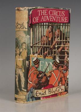
CHILDREN’S BOOKS. – Enid BLYTON. The Circus of Adventure. London: Macmillan and Co. Limited, 1952. First edition, 8vo (198 x 128mm.) Numerous illustrations by Stuart Tresilian. Original cloth (lightly bumped), dust-jacket (some tears and chipping, spine faded). – And a quantity of others, the majority children’s books including works by Helen Wells, Richard Crompton and others by Blyton (a quantity).
BINDINGS. – Julius Charles HARE. The Mission of the Comforter, with notes… second edition, revised. Cambridge: 1850. 8vo (219 x 129mm.) (Minor browning, spotting to first and last few leaves.) Contemporary calf gilt, the covers with centrally placed armorial of the Hulme Bequest (Munificentia Hulmiana), the spine in six compartments with raised bands, lettering piece in the second compartment, the others with repeat decoration in gilt (extremities lightly rubbed, spine darkened). – And twelve others, most leather-bound including a few others of religious interest (13).
BINDINGS. – William Makepeace THACKERAY. The History of Pendennis. London: Bradbury and Evans, 1849-1850. First edition in book form, 8vo (219 x 138mm.) Engraved frontispiece, additional decorative title and numerous plates. (Plates browned and spotted as usual, 1 leaf torn without loss.) Early 20th Century green half-morocco, t.e.g. (spines darkened to brown). – And twenty-two others, all leather-bound (24).
ARDIZZONE, Edward. Tim All Alone. London, New York, etc.: 1956. First edition, 8vo (253 x 189mm.) Illustrations throughout, some colour. (Occasional spotting.) Original pictorial boards, (bumped), dust-jacket (slightly browned and spotted). Provenance: Timothy W. Lockwood (inscription to front-free endpaper). Note: signed by the author to front-free endpaper and dated ‘Dec ‘04’. – And five others by Ardizzone (6).
MILITARY HISTORY. – U.H.R. BROUGHTON. The Dress of the First Regiment of Life Guards in Three Centuries. London: Halton & Truscott Smith Ltd., 1925. Limited edition of 300 copies, this number 183, 8vo (320 x 250mm.) Plates, including 40 tipped-in and colour. (Occasional minor spotting or browning.) Original pigskin (extremities and joints rubbed). – And one other volume (‘Roll of Honour, London and North Western Railwaymen who lost their Lives… during the Great War 1914-19’) (2).
CHAMBERLAYNE, Edward. Angliae Notitia: or, the Present State of England Compleat… the seventeenth edition. London: 1692. 12mo (163 x 90mm.) Engraved frontispiece. (Some browning, occasional spotting, first few leaves with marginal worm damage.) Near contemporary mottled calf (extremities rubbed and scuffed, spine worn, joints split). – And two other volumes (3).
FIELDING, Xan. The Stronghold, An Account of the Four Seasons in the White Mountains of Crete. London: Secker & Warburg, 1953. First edition, 8vo (217 x 140mm.) Portrait frontispiece, occasional illustrations. (Light browning and spotting.) Original cloth (extremities lightly bumped), dust-jacket (soiled, torn with some loss, backstrip darkened). – And one other of related interest (George Psychoundakis. ‘The Cretan Runner’. London: 1955. 8vo) (2).
JACKSON, Frederick John. The Birds of Kenya Colony and the Uganda Protectorate. London & Edinburgh: Gurney and Jackson, 1938. 3 vols., first edition, 8vo (255 x 175mm.) 24 colour plates, 1 folding map. (Occasional spotting or browning.) Original buckram, t.e.g. (extremities lightly bumped), dust-jackets (soiled, torn with some loss, a few tears repaired). Provenance: Arnold W. Boyd (review copy with publisher’s compliments slip, Manchester Guardian review request and a manuscript review loosely inserted in vol. I; passed to his nephew:); James Fisher (signatures to front-free endpapers). Note: James Fisher was an eminent naturalist, editor and broadcaster.
BURKE, Edmund. Reflections on the Revolution in France… ninth edition. London: 1791. [bound with:] Thomas PAINE. Rights of Man. London: 1791. 2 vols. bound in one, 8vo (198 x 123mm.) (Some spotting and browning, title-page to first work torn and repaired.) Late 19th Century cloth (worn, upper cover detached). Provenance: Edward Broderik (signatures to title-pages).
MILITARY HISTORY. – Jeffery WILLIAMS. First in the Field, Gault of the Patricias. London: Leo Cooper, 1995. First edition, 8vo (233 x 153mm.) Occasional illustrations. Original cloth, dust-jacket. Note: signed by the author to label pasted to front-free endpaper. – And a quantity of others of related interest (a quantity).
Flora H. Mitchell (1890-1973) VANISHING DUBLIN limited edition book; (from an edition of 600) 11.5 by 8.5in., 28.75 by 21.25cm. P Allen and Figgis, Dublin, 1966. First and only edition; the plates were destroyed after printing. A glimpse of old Dublin with fifty full colour plates and an introduction by the Earl of Wicklow. Quarto; original green cloth with gilt titled spine and dust jacket. Many of the 600 copies of this book have subsequently been broken up for the prints which were then sold individually. Other editions remain in public and special collections, thus Vanishing Dublin is a highly rare and desirable collectors item.
Jonathan Wade (1941-1973) TRIPTYCH, 1970 and SERIGRAPH 7, c.1970 (A PAIR) screenprint (from an edition of 10); (1); serigraph; (1) the first, signed and inscribed in the lower margin; second, signed, inscribed and dated in the lower margin; also with inscribed Davis Gallery label on reverse 5 by 15in., 12.5 by 37.5cm. L Neptune Gallery, Dublin and Davis Gallery, Dublin, respectively;Private collection `Jonathan Wade 1941-1973 Retrospective Exhibition`, The New Library Trinity College, Dublin, 23 May to 21 June, 1975, catalogue no. 54 as Triptych Dimensions of Serigraph 7: 10.25 by 6in. Both framed.Born in Pelletstown, Co. Dublin, Jonathan Wade was one of the most significant urban inspired artists Ireland has yet produced. His preoccupation with the urban and industrial landscape was largely a result of a Marxist philosophy combined with personal experience - he worked in an abattoir whilst studying by night at the National College of Art and was later employed in an oil company depot in London. His works have been described variously as ferocious, haunted and catastrophic (For further reading see Snoddy, pp. 682-683).
Pauline Bewick RHA (b.1935) HAZEL`S [HOUSE] and NEAR HAZEL`S, 1983 and WOMAN READING, 1981 pen and ink with watercolour; (2); colour print; (1); first edition books; (2) all signed inscribed and dated; books with illustrations and dedications within 3.75 by 5.75in., 9.375 by 14.375cm. L Family of the artist thence by descent Dimensions of each of the watercolours given (framed as one). Dimensions of print, 18 by 24in.Books included: Irish Tales and Sagas by Ulick O`Connor, Granada Publishing, 1981 and Pauline Bewick, Painting a Life by James White, Wolfhound Press, 1985. (4 Items total)
Sir William Orpen RA RI RHA (1878-1931) MINIATURE SELF PORTRAIT, 1925 and HUGH LANE AND HIS PICTURES by Thomas Bodkin ink on card; (1); limited edition book; (from an edition of 400); (1) the first signed, inscribed and dated 2.5 by 3.75in., 6.25 by 9.375cm. L Charming miniature self portrait of Orpen showing head and shoulders. With autographed noted, reads: With love, yours ever, William Orpen, London 1925.Hugh Lane and His Pictures, Pegasus Press, for The Government of The Irish Free State, Dublin, August 1932. Limited to 400 copies, pp.72 plus fifty pages of plates and corresponding text. Half green Morocco over marbled boards, with gilt-titled spine. Top edge also gilt. Book measurements, 12.50 by 9.5ins. (2 items total)"
Bry, Theodore de 1630 Willhelm Schouten Abfarth in die Sudsee This is the frontispiece to the German text edition of De Bry`s America. A double-hemisphere world map is shown with the track of Willem Schouten`s voyage around the world from 1615-17. Above the map are portraits of Ferdinand Magellan and Willem Schouten, both holding measuring dividers and being crowned with laurel wreaths by two angels. Flanking them are medallions with the portraits of other great explorers, including Francis Drake, Thomas Candish, Olivier van Noort and George van Spilbergen. This engraving is based on one originally published in Willem Schouten`s narrative of his voyage, first published by Willem Blaeu in 1618. 8.1"" W x 6.7"" H Watermarked paper with minor soiling and very narrow side margins.
Herrera y Tordesillas, Antonio de 1726 Historia General de los Hechos de los Castellanos en las Islas y Tierra Firme del Mar Oceano... Antonio de Herrera y Tordesillas was the official chronicler of the Spanish possessions in the Indies. His most important work, Historia General , begins with the history of the voyages of Columbus and includes events in America up to 1554, with the suppression of the revolt of Francisco Hernandez Giron in Peru. His work was originally published in 1601 with several editions and translations thereafter, all of which are scarce. This title page is from an early 18th century edition published by Nicolas Rodriguez. The engraving includes the royal coat of arms of Spain and portraits of famous Inca chiefs. At top center is a portrait of the legendary first Sapa Inca of the Kingdom of Cusco, Ayar Manco Capac, with his magic staff. Along the sides are portraits of 12 additional chiefs of the Inca Empire. 6.3"" W x 9.8"" H Minor soiling with a few small abrasions with no loss of image and a tiny hole only visible when held to light. The number ""2"" has been written in manuscript over the engraved number ""6"" in the date.
Sylvanus, Bernard 1511 [Untitled - World] ""This rare and distinctive """"modern"""" world map, from the 1511 edition of Ptolemy`s Geograhia, is an extremely early example of 16th century Venetian cartography and one of the earliest maps obtainable by today`s collectors. This Latin edition of Ptolemy was the first published in Venice, by Jacobus Pentius de Leucho, and was the first atlas to use two-color woodblock printing. The maps were printed in black with place names and headings printed in red ink by means of type set into the woodblock and applied with a second strike of the plate. The text was based on a Latin translation by Jacobus Angelus, with revised maps by Bernardus Sylvanus. Little is known of Sylvanus, a native of Southern Italy, although he is believed to have been a monk. Realizing that Ptolemy`s maps were outdated, Sylvanus set out to update them with modern information, often from contemporary manuscript sources. The resulting effect was an unusual hybrid of classical and modern information. Sylvanus also introduced a new world map, depicted for the first time in a distinctive cordiform (heart-shaped) projection, which was adopted by several later cartographers and used for a number of important 16th century maps. This world map was the first to show the newly discovered Americas in an edition of Ptolemy`s Geograhia, and presents a fascinating view of the post-Columbian world. South America, of which only the eastern coast is shown, is named Terra Sanctae Crucis but bears no additional place names. The islands of Cuba and Hispanola appear overly large and surrounded by numerous small, unnamed islands. Further north and quite close to Ireland are the island Terra Laboratorus and a partially delineated region named Regalis Domus, resulting from the Portuguese explorations of the Corte Real brothers in 1501. On the opposite side of the map the island of Zampagv (Japan), which appears for only the second time on a printed map. The first appearance being on the Contarini/Rosselli map of 1506, of which there is only one known copy. The land masses are vigorously engraved with mountain ranges, rivers and place names, and the map is surrounded by decorative wind heads and signs of the zodiac. Printed on two sheets, joined."" 22"" W x 16.3"" H A nice impression with light soiling, about 10 small worm holes (most only visible when held to light), and a couple of small chips along sheet edge at right, far from image. The bottom wind head has been partially cut off, apparently as issued as the to
Ritter, Franz 1607 [Untitled - World and Horological Diagrams] ""A rare and extremely unusual map shows the world projected from the North Pole as if it were the table of a sundial. Although at first glance it appears as if the landmasses are melting off the earth, they are actually drawn to scale based on a mathematical projection that links time and location. Ritter uses a gnomonic projection, in which surface points of a sphere are projected from the center of the earth onto a tangent plane. Meridians and the Equator are shown as straight lines, while all other parallels are depicted as ellipsis, parabolas or hyperbolas. In order to use the map to tell time, the center point would be 45°N 10°E, from which point a shadow would be cast onto a meridian to indicate the local sun time. The gnomonic projection was originally called horologium due to its relationship to sundials. The result is a very distorted, though mathematically correct, projection, with the distortion increasing rapidly away from the center point. The geography on the map is limited to major rivers and a few place names, including Florida in North America and the fabled golden city of Manoa on the mythical Parime Lacus in South America. The British Isles are curiously omitted, despite numerous small islands dotting the Atlantic. One small sea monster graces the waters between Africa and Madagascar. Surrounding the central map are ten horological diagrams, all enclosed in a decorative border. These diagrams include a windrose at top center (bearing the date Anno MDCVII), signs of the zodiac, and sundials for morning, midday and evening hours. The plate was designed for Ritter`s first edition of the Speculum Solis in 1607, and is a synopsis of all the plates that appear in his later editions. This is the first state."" 13.4"" W x 11.2"" H A nice impression on watermarked paper with a few small spots. Binding trims at left that have been replaced with old paper, with a small amount of neatline expertly replaced in facsimile. Issued folding, now pressed with a tear that enters 3"" into imag
Hondius/Mariette, 1642 Nova Totius Terrarum Orbis Geographica ac Hydpographica Tabula The Hondius world map of 1617 was the prototype for a series of maps by French publishers who combined Hondius` geographical information with the more scientific border decorations from Boisseau`s map of 1636. The map depicts the discovery of the Le Maire Strait at the tip of South America. In North America, the St. Lawrence River runs nearly the entire width of the continent, terminating in a large lake not far from the infamous Civolo 7 citta (7 cities of Cibola). Hudson Bay is depicted after the work of Gerritsz. In Asia, Korea is shown as an island, the northern coast of New Guinea is more properly located and there is a large Terra Australis Incognita with Boach named in the region of the Australian continent. The surrounding engravings include a pair of celestial charts, circular diagrams containing the compass points, the names of the winds, the climatic zones, the heavenly orbits and a thirty-year calendar. The map is richly adorned with a variety of decorations including three cartouches, two featuring native figures, numerous sailing ships, sea monsters, flying fish and a depiction of Neptune. This is the first state with Mariette`s imprint. Although dated 1642, this was likely published in the 1653 edition of Mariette`s Theatre Geographique de France. 22"" W x 15"" H A fine impression, issued folding and now flattened on watermarked paper with light soiling. There are professional repairs to a small hole at far left as well as a few short separations and tiny holes along the folds. The left and right margins have be
Danckerts, Cornelius 1710 De Werelt Caart This is Cornelius Danckerts` second world map; his first being a re-engraved version of his father`s map. This map is presented in the new scientific style popular at the turn of the 18th century. Danckerts retained the continental outlines from his father`s map, including the island form of California. However, he updated information on the course of the Mississippi from recent French discoveries. Terra Esonis stretches across the Pacific from just above California nearly to Asia and the land of Yedso above Japan. Tasman`s discoveries relating to Australia, New Zealand and Tasmania are shown in the Pacific. North and south polar projections appear at the top and bottom between the spheres. In each upper corner are illustrations of the Ptolemaic theory on the revolution of the planets and stars around the earth. In the lower corners are diagrams of the movement of the Sun throughout varying degrees of latitude, and a plan of the Sun, Moon and Earth during lunar and solar eclipses. There are extensive notations in Dutch at the top and a keyed table of latitude at the bottom. Dutch text on verso, from a Dutch Bible. This edition does not have Danckerts` imprint at bottom, which is more commonly found. 20.4"" W x 14.6"" H Nice impression and color on watermarked paper with minor toning and soling with narrow margins.
-
118894 item(s)/page


![[ASSORTED]. CRICKET & OTHER Tinkler, Basil. A Somerset Hero Who Beat the Aussies. The Life and Times of J.C. `Farmer` Wh](http://lot-images.atgmedia.com/SR/10066/2902790/251-2014228104817_468x382.jpg)
![[CRICKET]. Foot, David. A History of Somerset Cricket. Sunshine, Sixes and Cider, first edition, David & Charles, Newton](http://lot-images.atgmedia.com/SR/10066/2902790/255-2014228104827_468x382.jpg)




![GRANT, Duncan (illustrator). Samuel Taylor COLERIDGE. The Rime of the Ancient Mariner. [N.p. but London:] 1945. Limited editi](http://lot-images.atgmedia.com/SR/10123/2902926/3033-2014219153926_468x382.jpg)
![[SAINT, Dora Jessie] ‘Miss READ’. Village School. London: Michael Joseph, 1955. First edition, 8vo (200 x 133mm.)](http://lot-images.atgmedia.com/SR/10123/2902926/3043-2014219153946_468x382.jpg)





![BURKE, Edmund. Reflections on the Revolution in France… ninth edition. London: 1791. [bound with:] Thomas PAINE. Rights](http://lot-images.atgmedia.com/SR/10123/2902926/3201-201421915451_468x382.jpg)


![Pauline Bewick RHA (b.1935) HAZEL`S [HOUSE] and NEAR HAZEL`S, 1983 and WOMAN READING, 1981 pen and ink with watercolour; (2);](http://lot-images.atgmedia.com/SR/10092/2901686/94-201423164651_468x382.jpg)


![Sylvanus, Bernard 1511 [Untitled - World] ""This rare and distinctive """"modern""&q](http://lot-images.atgmedia.com/SR/36385/2901770/10-201425153635_468x382.jpg)
![Ritter, Franz 1607 [Untitled - World and Horological Diagrams] ""A rare and extremely unusual map shows the world](http://lot-images.atgmedia.com/SR/36385/2901770/15-20142515381_468x382.jpg)

