

A Map of Pennsylvania, with Part of the Adjacent States from the Latest Surveys Published in the second edition of The American Universal Geography from 1793 this first edition map focuses on Pennsylvania but extends to include New Jersey and parts of Delaware, Maryland, and New York. There is no Erie triangle indicating the map was drawn prior to 1792. Delaware is shown separated from Pennsylvania by a dotted line. Roads are denoted with fine dotted lines, watershed is well shown and many settlements are named. Locates Berlin, Pittsburgh, Mead`s Mill, Fort Franklin, Bedford, Greencastle, Shepherds T., Mt. Vernon, Buffalo Swamp, etc. The highest point in Pennsylvania is located. Compass rose at lower right orients north to the top of the page. Curiously, the lettering for Lake Ontario, Lake George and Oneida Lake are upside down, and Oneida Lake includes a second inscription that is correctly oriented. Longitude is measured from Washington at bottom and Philadelphia at top. Pennsylvania is spelled with two n`s on the map but with one in the title. There are a small edge tear at left and a fold separation at top, both confined to the blank margins and closed on verso with archival tape. Minor soiling. 7.2"" W x 7.8"" H Morse, Jedidiah (Rev.) 1793
We found 118894 price guide item(s) matching your search
There are 118894 lots that match your search criteria. Subscribe now to get instant access to the full price guide service.
Click here to subscribe- List
- Grid
-
118894 item(s)/page

Texas Compiled from the Latest and Best Authorities According to Rumsey, this map comes from a rare 1848 reissue of Greenleafs 1842 Universal Atlas. Greenleaf`s earlier 1842 map of Texas, which is nearly identical to this example, was based upon Burrs map of 1833 (which was the first to show the territorial claims that would eventually become the Republic). Texas is now part of the United States with the only update being the southern border now shown along the Rio Grande (the earlier edition conservatively had the border along the Nueces River) and the addition of San Patricio county. Development is confined to areas to the east of San Antonio and Austin, with the areas to the west void of detail except for the river system. Portions of Indian Territory, Arkansas and Louisiana are also shown. A nice impression with a few tiny edge tears and chips confined to the blank margins and minor toning along the top of the sheet. 10.7"" W x 12.8"" H Greenleaf, Jeremiah 1848
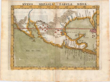
Nueva Hispania Tabula Nova This is a foundation map in the cartography of the American Southwest, and a must for collectors of that region. It is an enlarged version of Gastaldi`s map of 1548 with the only notable change being the peninsular Yucatan. The legendary seven cities of Ciuola are prominently depicted and Mexico City is shown floating in a large lake. The place names along the upper Gulf Coast reveal the explorations of Pineda, Cabeza de Vaca and Moscosso. The Mississippi makes its appearance as the Rio de Spiritu Santo and the R. Tontonteanc flows in the vicinity of the Colorado River. Considered the earliest relatively obtainable map of Mexico and the American Southwest. This is the first state according to Burden. Latin text on verso.See also lot 737 for the first edition of Ruscelli`s atlas, La Geografia de Claudio Tolomeo Allessadrino A dark impression on watermarked paper with faint offsetting, light text show-through, and minor toning along centerfold. 7.3"" W x 9.5"" H Ruscelli, Girolamo 1564

Audience de Guadalajara Nouveau Mexique, Californie, &c. This map was first published in 1656 and introduced the so-called second Sanson model of California as an island. This depiction shows a small peninsula (Agubela de Cato) above the island, two bays along the island`s northern coast and two new place names, Tolaago and R. de Estiete. Sanson actually based this on information from the less well known map by Luke Foxe, but it was this map that influenced many other cartographers throughout the rest of the century. On the mainland there are new Indian tribes identified in the region of the R. del Norte, which flows southwest from a large inland lake. The map was re-engraved for this edition, with only very minor differences from Sanson`s map of 1657. This is the second state of the Ribbius edition, with the addition of a grid of longitude and latitude. A dark impression, issued folding, with minor printer`s ink residue and a professionally repaired tear confined to right blank margin. 8"" W x 9.4"" H Sanson, Nicolas 1700
![[Lot of 2] Amer. Sep. Partie de la Nouvle. Californie. No. 52 [and] Amer. Sep. Partie de la Vielle Californie. No. 53 A. Ame](http://lot-images.atgmedia.com/SR/36385/2916721/328-2014116144015_468x382.jpg)
[Lot of 2] Amer. Sep. Partie de la Nouvle. Californie. No. 52 [and] Amer. Sep. Partie de la Vielle Californie. No. 53 A. Amer. Sep. Partie de la Nouvle. Californie. No. 52, (19.7 x 18.3""). This map features the central California coast from approximately Monterey south to Catalina Island. A chart of elevations fills the bottom of the map. Condition: Original color with light toning and foxing with a small damp stain confined to the top blank margin. B. Amer. Sep. Partie de la Nouvle. Californie. No. 53, (20.8 x 18.5""). This sheet shows the coast from San Juan de Capistrano to about Santa Rosalita, including the north end of the Sea of Cortez and the mouth of the Colorado River, and inland to Tucson (Pres. de Tubson). There are many notes on the Native tribes and the landmarks of San Xavier del Bac and Casa Grandes are shown. Condition. Original color with a few faint stains and light scattered foxing. The Atlas Universel contained 400 maps in six volumes. It was the first atlas made up of lithographed maps, and the first to present all the maps on the same scale (1: 1,641,836), with each map covering an area of approximately 20 degrees longitude (from Paris) and 6 degrees of latitude. If all the maps were joined together they would form a globe of 7.75 meters in diameter. The maps were published by subscription between 1825 and 1827, with each part containing ten maps. There was only one edition and the subscription list shows that 810 copies were sold; thus the maps are quite rare. See description See description Vandermaelen, Philippe Marie Guillaume 1825
![[On 4 Sheets] A New Map of Mexico and Adjacent Provinces Compiled from Original Documents This is one of the most important](http://lot-images.atgmedia.com/SR/36385/2916721/330-2014116144019_468x382.jpg)
[On 4 Sheets] A New Map of Mexico and Adjacent Provinces Compiled from Original Documents This is one of the most important maps of Texas and the Southwest from the early 19th century. Arrowsmith`s map was the first to incorporate the discoveries of both Zebulon Montgomery Pike and Alexander von Humboldt. Pike`s official account had just become available in 1810, and Humboldt`s map of New Spain was published in 1811. It is not known how Arrowsmith obtained an early copy of Humboldt`s map, and Humboldt accused him of plagiarism for neglecting to properly credit his work. However, Arrowsmith`s success came from relying on multiple sources of information. He carefully sifted through conflicting data between explorers and incorporated the most accurate cartographical information to create the most accurate, up-to-date map of the region.The California coastline was based on the explorations of Vancouver, whose track is noted in the map, as well as information provided to Arrowsmith by the Hudson`s Bay Company. The Rocky Mountain region and the Gulf Coast draw primarily on Humboldt, while present-day Texas and the Brazos and Guadalupe River regions were based on Pike`s accounts. The Dominguez-Escalante Expedition of 1776 from Santa Fe through present-day Colorado, Utah, and Arizona is also depicted. Additional notes on the mapping of the region are provided throughout the map.The eastern boundary of US and Mexico extends approximately 50 miles east of the present-day boundary of Texas at the Sabine River, to the Mermentau River in Louisiana. This was the official Spanish stance on the eastern boundary as reported by Humboldt. The boundary follows the Mermentau River to the northeast and then turns to the northwest until it passes the 32nd parallel just south of the Red River, and then begins to head southwest. Between the 99th and 100th meridians, the boundary again turns northwest up to the town of San Saba, which remains under Spanish control. The boundary then again heads southwest until it reaches the Rio del Norte.The map includes three inset maps of locations in Mexico. Below the title cartouche is the Valley of Mexico, from Mr. Humboldt`s Map showing the area surrounding Mexico City with excellent topographical detail, as well as towns, roads, and rivers. The other two insets illustrate the harbors of Veracruz and Acapulco, with numerous soundings, rocks, shoals, anchorages and navigational notes.There were several editions of the map with corrections in 1815, 1816, and 1817, with a note in the title indicating the date of the additions. A final edition was published in 1825 with further corrections, including the US-Mexico boundary reflecting the Adams Onis Treaty of 1819, although this edition is still dated 1810, and is occasionally mistakenly identified as the first edition (including by Streeter). According to Martin & Martin, Arrowsmith was able to synthesize the best information from various explorers, while omitting their errors, thereby creating a ""significantly improved depiction of the region."" Arrowsmith`s map of Texas and the southwest is a landmark map that was one of the most influential and widely copied maps for several decades.Printed on four double elephant-folio sized sheets. Size is for each sheet, which varies slightly. If joined, the map would measure approximately 62 x 50.5"". Fine impressions and bold original color on sturdy paper with ""J. Whatman 1811"" watermarks. There is light offsetting on each sheet, which are otherwise clean and bright. The bottom left sheet has a hint of toning along the centerfold and a 1/2"" centerfold separation at bottom. Please note that the image of the map as a whole is a composite image - the four sheets are not joined. 25.4"" W x 31.1"" H Arrowsmith, Aaron, Sr. 1810

Mexico This is the first edition of Arrowsmith`s folio-sized map of southwestern United States, Texas and Mexico, and was published four years prior to Texas gaining independence from Mexico. In Upr. or New California, there is an American Fur Co. Depot on the eastern shore of Youta or Gt. Salt L.. The Great Spanish Road is shown extending from the Red River on the US-Mexico boundary and past Santa Fe to Nutrias. A note through present-day New Mexico states that the area is ""frequented by roving bands of Indians who roam about in the quest of game."" A large inset depicts central Mexico, centered on Mexico City and showing the important ports of Acapulco, Vera Cruz and Tampico. Original color on sturdy paper with a few tiny, unobtrusive spots. 19.1"" W x 23.7"" H Arrowsmith, John 1832
![[Lot of 2] Amer. Sep. Curacao. No. 74 [and] Amer. Sep. Grandes Antilles. No. 73 The Atlas Universel contained 400 maps in si](http://lot-images.atgmedia.com/SR/36385/2916721/366-2014116144122_468x382.jpg)
[Lot of 2] Amer. Sep. Curacao. No. 74 [and] Amer. Sep. Grandes Antilles. No. 73 The Atlas Universel contained 400 maps in six volumes. It was the first atlas made up of lithographed maps, and the first to present all the maps on the same scale (1: 1,641,836), with each map covering an area of approximately 20 degrees longitude (from Paris) and 6 degrees of latitude. If all the maps were joined together they would form a globe of 7.75 meters in diameter. The maps were published by subscription between 1825 and 1827, with each part containing ten maps. There was only one edition and the subscription list shows that 810 copies were sold; thus the maps are quite rare. Included in this lot are: A. Amer. Sep. Curacao. No. 74 (22.0 x 19.7""). Shows the island of Curacao along with Aruba, the northern tip of Venezuela, and the southern coast of the Dominican Republic. A large panel of text at center describes Haiti`s phsical features, government and geology. Condition: Light toning and scattered foxing. (B+) B. Amer. Sep. Grandes Antilles. No. 73 (21.6 x 18.0""). Depicts a portion of the southern coast of Jamaica along with Banc Pedro and Cayo Alburquerque. Includes a panel of text describing Jamaica`s topography and climate. Condition: Scattered foxing and toning. (B) See description See description Vandermaelen, Philippe Marie Guillaume 1825

Isle St. Vincent Levee en 1773. Apres le Traite Fait avec les Caraibes. Traduit de l`Anglais This handsome copperplate map of St. Vincent is the first French edition of Thomas Jefferys` 1775 map of the island. The mountainous terrain is well defined and settlement is shown along the coastlines and rivers. The treaty to which the title refers was short-lived and it was not until 1797 that Carib resistance was finally crushed. The island was an important part of the British presence in the Caribbean due to sugar production. A note below the title explains that ""the island is 18 miles 1/8 long, and 11 miles 1/5 broad, has 22 rivers capable of turning sugar mills, and contains 84,286 acres."" The map illustrates the important rivers and shows the four parishes. The northern part of the island is noted as Terre des Caraibes where the Morne a Garou mountains dominate the topography. Watermarked paper with light offsetting and faint damp stains that just enter neatline in corners at right. 23.8"" W x 18"" H Le Rouge, George Louis 1778

Carte du Paraguay, du Chili, Detroit de Magellan, & Terre de Feu: dans l`Amerique Meridionale A large, handsome map of the southern part of the continent with good interior detail for the period. The routes of 18th century explorations are shown along with notations concerning their discoveries. The map includes two large inset. The first shows the Strait of Magellan in detail, with soundings, anchorages, rocks, shoals and a navigational note. The second is a south polar view extending to the equator, with a partially delineated Hollandia Nova and the South Pole labeled Polus Antarcticus and Australia Inaccessa. A large title cartouche, compass rose and a tiny ship decorate the map. This is the scarce first edition by Visscher, not the Covens & Mortier issue. Full original color on watermarked paper with faint offsetting and two light damp stains at top, entering less than 1"" into map image. 19.9"" W x 23.1"" H Visscher, Nicolas 1705

A New Chart of the Vast Atlantic Ocean; Exhibiting the Seat of War, both in Europe and America Fine copper engraved chart details the trade winds and sailing courses across the Atlantic. The area covered includes most of eastern North America through northern South America, and western Europe through northwestern Africa. Ornamented with rhumb lines, a beautiful compass rose and a decorative scroll-style title cartouche. The map is filled with numerous notes and comments. A note below the title details Bowen`s sources, including Capt. Cyprian Southacks 1731 map of New England, Edward Moseleys 1733 map of North Carolina, and James Wimbles 1739 map of the Carolinas. A table at top center compares position data between this map and ""Mr. Popple`s great Map of the British Empire in North America."" Jolly calls this ""a nicely executed map."" This is the first edition and not to be confused with the 1755 state. Issued folding with just a few faint spots and one tiny hole to the east of the Azores that has been professionally repaired. A binding trim at lower right has replaced with old paper, and an associated 1/4"" binding tear has been professionally repaired. 12"" W x 16.8"" H Bowen, Emanuel 1740

Islandia This important map first appeared in the 1595 edition of Mercator`s Atlas. It is similar to Ortelius` map of Iceland (issued five years earlier) and is based on the same source - that of Bishop Gudbrandur Thorláksson. Although the map is far from accurate, it is a marked improvement on earlier maps in both content and execution. The island is depicted with its vast mountains, glaciers and fiords and the eruption in Hekla. The settlements are fairly well located and many places of interest are named. The map is decorated with a strapwork title cartouche, a sea monster and a distance scale topped with dividers. Latin text on verso. A nice impression with attractive color and marginal soiling. There are professionally repaired centerfold separations at top and bottom, only entering map 1.5"" at bottom, and a small chip in bottom blank margin has also been professionally repaired. 11.2"" W x 17.4"" H Mercator/Hondius, 1623

Europa/ die Erst Tafel des Ersten Buchs This rare and striking woodcut map of Europe is oriented with south at the top. Although the map is a derivative of Munster`s map of Europe, first published in his Cosmographia in 1544, it supersedes Munster`s map with its elaborate decorations. The continent is filled with miniature bird`s-eye views of towns, trees, exaggerated rivers, and rope-like mountain ranges. The surrounding waters are teeming with galleons and sea monsters of every variety, reminiscent of Olas Magnus` Carta Marina. At the top of the map, to the right of Sardinia, is the sea God Triton, who plays music to calm or raise the waves in the sea. The various seas are labeled in decorative cartouches.This map was first published in Stumpf`s Gemeiner Loblicher Eydgnoschafft, which was the first national atlas of Switzerland, and the first national atlas published in Europe. Twenty-three woodblock maps were included in the first edition of Stumpf`s atlas, of which 10 were acquired from Honter`s Rudimenta Cosmografica. The remaining 13 maps, including this map of Europe, were newly engraved for Stumpf`s atlas based on the work of Waldseemuller and Munster. It is believed that Stumpf`s atlas was such an excellent example of bookmaking that it incited Munster to make significant improvements to his second edition of Cosmographia. An excellent impression with original margins, light toning along the centerfold, and a few small spots of foxing. There is marginal soiling and an archivally repaired centerfold separation in the bottom blank margin, far from map. 11"" W x 15.4"" H Stumpf, Johann 1548

Memoires de la Classe des Sciences Mathematiques et Physiques de l`Institut Imperial de France In this volume, Cuvier and Brongniart provide an expanded version of their important work on the Tertiary rocks of the Paris basin, first published in 1808, with a special part devoted to geological descriptions, maps, and sections. Their revised stratigraphic sequence included formations that were unknown in Werner`s rock classification system later adopted as Tertiary after the terminology first suggested by Arduino. Geikie credits them with establishing ""on a basis of accurate observation the principles palaeontological stratigraphy"" by showing a definite succession among the strata using fossils for establishing geological chronology and correlating formations over distances. Still bound into the book is their large map of the Paris basin, entitled Carte Geognostique des Environs de Paris (28 x 24"") which beautifully displays geologic features in 11 colors and patterns. Gohau, Carozzi and Carozzi (A History of Geology) state that this map ""was in fact the first modern geological map of France, or of a European country."" Accordingly, this report and map represent a landmark in the history of geology. Also contained within this volume is Laplace`s Memoire sur les Integrales Definies, et Leur Application aux Probabilities... plus papers by Mirbell, Bosc, Lelievre, Berthollet, Malus, and Legendre. First edition, complete volume divided into two parts (347 pp. & 183 pp.) with 3 engraved plates (2 folding) and large folding map. Hardbound in full tree calf with gilt title on spine, gilt floral decorations on the front cover and blue marbled endpapers and fore-edges. The map is near fine with just a hint of offsetting. Contents are clean and tight. There is a 1"" split along the bottom of the front joint, the covers are lightly worn and the corners are bumped. An overall very attractive example. 10.3"" W x 8.1"" H 1811
![[Title Below Map] This Mappe Declareth the Way Which the Israelites Went for the Space of Fortie Yeares from Egypt Thorow th](http://lot-images.atgmedia.com/SR/36385/2916721/606-2014116144843_468x382.jpg)
[Title Below Map] This Mappe Declareth the Way Which the Israelites Went for the Space of Fortie Yeares from Egypt Thorow the Wildernesse of Arabia This anonymous woodcut map displays the route of the Exodus. The daily progress is also noted by use of numbers placed alongside the route. The leaf is from the 1599 edition of the Geneva Bible printed by Christopher Barker, the printer for Queen Elizabeth I. The Geneva Bible was significant because it was the first mechanically printed, mass-produced Bible made available to the general public. On a full sheet of English text (6.3 x 8.5""). Light soiling mostly in the blank margins. 4.1"" W x 5"" H 1599
![Descriptio Acurata Terrae Promissae per Sortes XII [on sheet with] Terre Sainte Moderne que les Turcs, sous la Domination de](http://lot-images.atgmedia.com/SR/36385/2916721/610-2014116144851_468x382.jpg)
Descriptio Acurata Terrae Promissae per Sortes XII [on sheet with] Terre Sainte Moderne que les Turcs, sous la Domination des quels Elle est, Auiourdhuy, Divise. Nt en Sangiacs ou Gouvernements This large, uncommon sheet contains two maps. On the left is an ancient map of the Holy Land that depicts the Promised Land divided into the twelve tribes. On the right is a `modern` map that shows the region under Turkish rule and divided into provinces. The sheet provides a wealth of information, both in the maps and in the accompanying French text. The maps were created by Nicolas de Fer based on the work of Philippe de la Rue and first published in de Fer`s Atlas ou Recueil de Cartes Geographiques circa 1720. The right-hand map has the publisher`s imprint of Guillaume Danet, son-in-law and successor of de Fer, however this edition was published by Louis Charles Desnos, who reissued several of Danet`s works, and whose imprint has been added to the left-hand map. Very light soiling. 18"" W x 28.1"" H Fer, Nicolas de 1770

Lant Kaarte, van `t Oost Tartarie This fascinating map of northeastern Asia by Nicolaas Witsen shows numerous geographical misconceptions. Although Korea is correctly shown as a peninsula, there are conjectural dotted lines connecting it to Eso (Hokkaido). Further to the east is Compagnies Lant, which was supposedly discovered by Jean de Gama. A long, slender peninsula protrudes east from northeastern Siberia -- presumably the Kamchatka Peninsula -- with a notation that it consists of ""ice and stone cliffs."" The Amur River is shown flowing west, rather than south-southwest, with its mouth in the Sea of Okhotsk (Oceanus Orientalis), rather than in the narrow Strait of Tartary, which divides the Russian mainland from the island of Sakahlin. In China, the Great Wall is prominently depicted and several cities are named. In this map, Peking is correctly shown at 40 degrees latitude, which had been measured by the Jesuits. (However in Witsen`s similar map of the region, Peking is incorrectly depicted at 44 degrees latitude. See lot 621.)Nicholaas Witsen (1641-1717) was a Dutch statesman, administrator of the VOC, and cartographer. After studying Russia for over 20 years, Witsen became the first to publish a comprehensive work on Siberia and the Far East, Noord en Oost Tartarye, first published in 1685. There were several editions, often containing updated maps. This map appeared in the first edition as well as at least one 18th century edition. A nice impression on watermarked paper. Issued folding with one short fold separation in bottom blank margin that has been archivally repaired. 11.1"" W x 14.5"" H 1685

Nieuwe Lant-Kaarte, der Tartars van Niuche This fascinating map of northeastern Asia by Nicolaas Witsen shows numerous geographical misconceptions. Although Korea is correctly shown as a peninsula, there are conjectural dotted lines connecting it to Eso (Hokkaido). The Amur River is shown flowing west, rather than south-southwest, with its mouth in the Sea of Okhotsk (Oceanus Orientalis), rather than in the narrow Strait of Tartary, which divides the Russian mainland from the island of Sakahlin. In China, the Great Wall is prominently depicted and several cities are named. Peking is shown at 44 degrees latitude, despite the fact that the Jesuits had correctly measured it at 40 degrees latitude. Although Witsen was aware of this discovery, he chose instead to use the figure determined by Dutch Jesuit Father Verbiest, who had calculated the latitude and brought his findings to Witsen. As a result, many of the remaining cities noted are also miscalculated by 4-7 degrees. (However in Witsen`s similar map of the region, Peking is correctly depicted at 44 degrees latitude. See lot 620.)Nicholaas Witsen (1641-1717) was a Dutch statesman, administrator of the VOC, and cartographer. After studying Russia for over 20 years, Witsen became the first to publish a comprehensive work on Siberia and the Far East, Noord en Oost Tartarye, first published in 1685. There were several editions, often containing updated maps. This map appeared in the first edition as well as at least one 18th century edition. A nice impression on watermarked paper with wide margins. 5.6"" W x 7.3"" H 1685

Tab. III. Africae, in qua Cyrenaica, Marmarica, ac Lybia Exterior... Great Ptolemaic map of eastern Libya and Egypt with numerous ancient place names, particularly along the course of the Nile. The interior is filled with fanciful animals and monsters including a superb dragon. Mercator originally published this map in his 1578 edition of Ptolemy`s great Geography. Although he is most renowned today for the projection he popularized and for first using the term Atlas for a collection of maps, he devoted much of his life to his Ptolemaic maps. The maps were beautifully engraved as nearly as possible to their original form and embellished with fine cartouches. A nice impression with minor soiling and centerfold separations in top and bottom margins that have been archivally repaired. 13.3"" W x 18.6"" H Ptolemy/Mercator, 1730
![Uebersicht der Entdeckungen in Central Africa... [in] Neue Allgemeine Geographische und Statistische Ephemeriden
This is a](http://lot-images.atgmedia.com/SR/36385/2916721/694-2014116145120_468x382.jpg)
Uebersicht der Entdeckungen in Central Africa... [in] Neue Allgemeine Geographische und Statistische Ephemeriden This is a reduced, German edition of Map of the Travels and Discoveries made in Northern & Central Africa, by Dr. Oudney, Major Denham & Captn. Clapperton R.N., in the years 1822, 3, & 4 published in the Narrative of Travels and Discoveries in Northern and Central Africa . The British trio was sent to the region to establish trade links in Western Africa and to specifically trace the route of the Niger River. The map depicts their course from Tripoli, across the Sahara Desert, to the kingdom of Bornu. While they were the first documented Europeans to visit Lake Chad and proved that it was not the source of the Niger, they were unable to trace the river`s course due to local leaders` concerns that they would interfere with the local slave trade. Includes a 64-page article on their journey. Map is still bound in the 490-page text. Octavo, hardbound with marbled boards. Condition code is for the map which is crisp and bright with just a few tiny spots and a binding trim confined to the left blank margin that has been closed with archival tape on verso. Deckled text has some light toning along sheet edges. Covers are moderately rubbed with the bottom corners chipped (B). 19"" W x 12.8"" H Geographisches Institut, 1825

Africa Nuova Tavola This ""new"" map of the southern part of Africa includes some unusual cartography. It is based on Gastaldi`s map of 1548. The continent is very broad and the source of the Nile is shown in three lakes, instead of the normal two. Madagascar, Isola de S. Lorenzo, is oddly shaped and surround by smaller islands. It is engraved in the typical Italian style with stippled sea, wide rivers and anthill-like mountains. Italian text on verso.See also lot 737 for a complete first edition of Ruscelli`s Geographia, and 774 for Norwich`s excellent reference work, which describes this map. A nice impression on watermarked paper with a stain at the southern tip of the continent and two light red pencil marks. 7.3"" W x 9.8"" H Ruscelli, Girolamo 1574

La Geografia di Claudio Tolomeo Alessandrino, Nuovamente Tradotta di Greco in Italiano... This is the first edition of Girolamo Ruscelli`s translation of Claudius Ptolemy`s Geographia, published in Italian. It was printed by Vincenzo Valgrisi in Venice, with the text translated from Greek by Ruscelli. It is complete with 62 maps; 25 classic and 37 modern, which are enlarged copies of the maps created by Giacomo Gastaldi for his 1548 edition of Ptolemy. These maps demonstrate the amazing advances in geographic knowledge taking place in this great era of exploration. They are from finely engraved copper plates, which were a great improvement over the rather crude woodcut maps in many of the earlier editions. The maps were engraved two to a plate, then printed and separated for binding, which is why the plate mark for each map runs off the top edge of the page. The classic maps include a conical projection of the world, 10 maps of Europe, 4 of Africa, and 12 of Asia. The modern maps include two world maps, 17 maps of Europe, 5 of Africa, 6 of Asia, and 7 maps of the Americas.Orbis Descriptio is the first double-hemisphere world map to appear in atlas form. It is elegantly engraved in the characteristic Italian style, adapted from the oval projection used by Gastaldi, and presented on what is known as Roger Bacon`s circular projection. This projection was popularized by Ruscelli and later by Rumold Mercator. Another important feature of the map is the apocryphal bulge in South America; one of the most copied cartographic errors of the 16th century. Terra Incognita is distinctly shown as a land bridge linking Asia and North America with its coastline labeled Littus incognitum. This is the first state with no southern continent.Ruscelli`s important early map devoted to the East Coast of North America, Tierra Nueva, is based on Giacomo Gastaldi`s map of 1548, which combined data from the Verrazano and Cartier voyages. The cartography is unchanged, with the exception of the depiction of the Hudson and St. Lawrence Rivers (unnamed), which are shown connected upriver, a notion he borrowed from Ramusio. Engraved on copper by Giulio and Livio Sanuto in the unmistakable Italian style.Also included is Nueva Hispania Tabula Nova, a foundation map in the cartography of the American Southwest, and a must for collectors of that region. It is an enlarged version of Gastaldi`s map of 1548 with the only notable change being the peninsular Yucatan. The legendary seven cities of Ciuola are prominently depicted and Mexico City is shown floating in a large lake. The place names along the upper Gulf Coast reveal the explorations of Pineda, Cabeza de Vaca and Moscosso. The Mississippi makes its appearance as the Rio de Spiritu Santo and the R. Tontonteanc flows in the vicinity of the Colorado River.Complete, 358 pages, 62 maps, and index. Bound with the 47-page Discorso Universale de M. Gioseppe Moleto Matematico.... Original vellum binding with brown ink manuscript title on spine. The text and maps are bright with light foxing and a faint damp stain at top right, entering up to 1"" into some maps. Most of the maps are in very good to near fine condition, with a few only in good condition. The first 40 pages of text also have a damp stain along the spine. There are some manuscript notations and a previous owner`s stamp on the title page. The hinges are starting and the covers show some wear with a few small worm tracks. 9.3"" W x 6.4"" H Ptolemy/Ruscelli & Valgrisi, 1561

Carey`s Minor American Atlas; Containing Nineteen Maps... This is the complete first edition of this very rare atlas, which was published again in 1810. It contains largely the same maps as in Carey`s American Pocket Atlas, first published in 1796. The 19 maps in the atlas are: United States, Vermont, New Hampshire, Maine, Massachusetts, Rhode Island, Connecticut, New York, New Jersey, Pennsylvania, Delaware, N.W. Territory, Maryland, Virginia, Kentucky, North Carolina, Tennessee, South Carolina, and Georgia. The map of the United States is a larger folding map, while the remaining maps are all single page. The title explains that the maps are ""with the main roads correctly laid down."" The maps are engraved by William Barker, Amos Doolittle, and J. H. Seymour.The first map, ""The United States of America,"" depicts the young country stretching west to the Mississippi River. The states and territories are named with marked boundary lines, including Georgia, which extends from the Atlantic to the Mississippi River. Between Georgia and Florida is the short-lived Mississippi Territory. Rivers, topographical features, and towns fill the map. A large Northwest Territory is shown, with Bellin`s mythical islands in Lake Superior, and a Grand Portage extending west.The individual map of the Northwest Territory shows the land north of the Ohio River and east of the Mississippi, and mirrors the same features in and around Lake Superior as the United States map. A large portion of Michigan is labeled as an extensive high plain. Present-day Ohio is divided into Indian lands, Army lands, Virginia lands, and the Seven Ranges, which was the first tract to be surveyed under the Public Land Survey System. Numerous forts and towns are named, including Chicago and Detroit.The significant map of Georgia covers from the Atlantic seaboard to the Mississippi River; present-day Georgia, Alabama and Mississippi. There is good topographical information particularly in the north. Towns, Indian villages, and rivers fill the map. The road system exists only in the far eastern region of the state. Mississippi Territory is not shown, and Florida is divided into East and West, with a large swamp noted in East Florida.The Province of Maine shows the boundary line with New Brunswick (here called Nova Scotia) further to the east than the present-day boundary. Roads extend the length of the coastline, with numerous small towns noted along the way. The interior of the province is filled with rivers, lakes and mountain ranges.This rare atlas gives a fascinating view of the states and territories at the beginning of the 19th century. 4to, with marbled paper boards and a new, brown faux-leather spine. The majority of the maps are in good condition with toning, scattered foxing, and a few small stains. The folding map of the United States has moderate offsetting. The maps of Vermont, New Hampshire, Maine and Massachusetts are in satisfactory condition with more significant stains. The covers are heavily rubbed with bumped corners and some stains. The front paste-down has the name of a previous owner, Benjamin S. Webb, written in manuscript ink. 10.6"" W x 8.4"" H Carey, Mathew 1802
![[Lot of 3] The Vinland Map and the Tartar Relation [and] The Vinland Map and the Tartar Relation ... New Edition [and] Proce](http://lot-images.atgmedia.com/SR/36385/2916721/765-2014116145329_468x382.jpg)
[Lot of 3] The Vinland Map and the Tartar Relation [and] The Vinland Map and the Tartar Relation ... New Edition [and] Proceedings of the Vinland Map Conference A. The Vinland Map and the Tartar Relation, by R.A. Skelton, Thomas E. Marston, and George D. Painter, published 1965, black & white (9.1 x 11.8""). 291 pages with 30 illustrations and maps. This book analyzes 2 documents that surfaced in the late 1950`s. The first is a manuscript account of the expedition of Friar Carpini across Central Asia on a mission to the Mongols in 1245-47. The second is a world map including the Western Ocean with representations of Iceland, Greenland and a land mass named ""Vinland"" (the North American mainland as known to the medieval Norsemen). Hardbound in red boards. Condition: The spine is sunned and dust jacket missing. Contents very good. B. The Vinland Map and the Tartar Relation ... New Edition, by R.A. Skelton, Thomas E. Marston, and George D. Painter, published 1995, printed color (9.3 x 11.8""). New edition of the above title with an introduction by George Painter and essays by Wilcomb Washburn, Thomas Cahill, Bruce Kusko and Laurence Witten, II. The Vinland Map is reputed to be the only pre-Columbian map showing Norse discoveries in America. The claim is that if this part of the map originated in the North, and probably in Iceland, it represents the only surviving medieval example of Norse cartography. Painter`s new introduction presents scientific and humanistic evidence of the map`s authenticity, while the new essays focus on the maps provenance, the tests that have been performed on it, and its compositional and structural aspects. Also included is an account by the rare-book dealer who sold the map. 291 pages plus 65 pages of new material with 9 figures (maps) and 4 color plates, plus a large folded map (figure 1), 19 plates (3 large folded), and 26 pages of the facsimile of the original manuscript. Condition: Contents very good with a few short tears on the dust jacket.C. Proceedings of the Vinland Map Conference, by Wilcomb E. Washburn, published 1971, black & white (8.8 x 11.3""). Two-page color plate of the Vinland Map, black & white illustrations. A comprehensive chronicle of the debate surrounding the then controversial Vinland Map. If genuine, the Vinland Map, believed to be printed mid-15th Century, is the only known pre-Columbian map showing the existence of North America. Edited by Washburn and published for the Newberry Library by The University of Chicago Press. Maroon cloth and blue boards, with dust jacket. 185pp. Condition: Contents very good with one small chip and an unobtrusive abrasion on the dust jacket, else fine. See description See description 1965-95
![[Lot of 2] The Cartography of North America 1500-1800 [and] A Book of Old Maps Delineating American History A. The Cartograp](http://lot-images.atgmedia.com/SR/36385/2916721/766-2014116145330_468x382.jpg)
[Lot of 2] The Cartography of North America 1500-1800 [and] A Book of Old Maps Delineating American History A. The Cartography of North America 1500-1800, Portinaro & Knirsch, published 1987, hand color (9.8 x 13.1""). This essential and nicely illustrated cartographic reference is filled with biographical sketches of major cartographers. It presents reproductions of authentic maps from the first three centuries of the mapping of North America reflecting an unfolding story of daring exploration, tenacious settlement, and fierce colonial rivalry. 320 pp. containing 180 extensively captioned maps, nearly all in full-color and over 90 supplementary illustrations. Published by Chartwell Books, Edison NJ, 1987. Hardbound in blue cloth with dust jacket.B. A Book of Old Maps Delineating American History from the Earliest Days Down to the Close of the Revolutionary War, Fite & Freeman, published 1969, black & white (10.1 x 14.5""). An excellent study of American cartographic developments in 74 selected maps made between 1474 and 1825. These maps provide a unique view of an important stage in the growth of America. Each map has an accompanying essay describing its background and historical importance. Illustrated in black and white, 299 pages, hardbound with gilt title on front cover and spine. Compiled and edited by Emerson D. Fite & Archibald Freeman, Arno Press, New York, 1969. Reprint of the Harvard University Press edition of 1926. Near new condition with minor wear to dust jackets. See description 1969-87
![[Lot of 3] The Dictionary of Imaginary Places Expanded Edition [and] Animals & Maps [and] Cartographical Curiosities A.](http://lot-images.atgmedia.com/SR/36385/2916721/767-2014116145332_468x382.jpg)
[Lot of 3] The Dictionary of Imaginary Places Expanded Edition [and] Animals & Maps [and] Cartographical Curiosities A. The Dictionary of Imaginary Places Expanded Edition, by Alberto Manguel and Gianni Guadalupi, published 1987 (8.6 x 12.1""). This is the updated edition of this fascinating reference book that features over 1,200 entries detailing fictional and often fantastic locales. Homer, Swift, Carroll, Coleridge, Kafka, Verne, Calvino, and Tolkien are among the writers whose invented realms are explored. The book includes over 200 illustrations, many of them maps of the lands discussed, including Robinson Crusoe`s Island, Oz and its surroundings, and Narnia. Paperback, 454 pp., with an index. Condition: Contents fine with some minor wear to the cover and spine. The bottom corner of the back cover and later pages is slightly bent. A price sticker is on the back cover. B. Animals & Maps, by Wilma George, published 1969 (6.3 x 9.8""). First edition of this book that shows that cartographers had a sound knowledge of the animals and their distribution on the various continents. Ristow says that George ""...argues convincingly that the mapmakers knew what they were about and that Renaissance and later maps provide much useful source material on contemporary natural history."" Another reference says that the book ""...seeks to support the thesis that animals portrayed on ancient maps are zoogeographically [sic] significant."" Hardbound with a dust jacket, octavo, 235 pp., ten page bibliography, index. Profusely illustrated in black and white. An unusual cartographic reference book with an interesting thesis that is a useful read for all map collectors. Condition: Internally clean with minor soiling on the cover, slight wear to the dust jacket, and a small chip on the inside of the dust jacket.C. Cartographical Curiosities, by Gillian Hill, published 1978 (9.7 x 7.4""). This reference book corresponds to the British Library Map Library`s 1978 exhibition of the same title. It discusses unusual and outlandish maps, including satirical maps, geographical misconceptions, invented lands, and maps with a symbolic shape. Features numerous illustrations. Paperback, 63 pp., with a complete list of the exhibits at the end. Condition: Contents and cover fine with a price sticker on the back cover. See description See description 1969-87
![[Lot of 4] Investing in Maps [and] Antique Maps for the Collector [and] Collecting Antique Maps An Introduction to the Histo](http://lot-images.atgmedia.com/SR/36385/2916721/768-2014116145333_468x382.jpg)
[Lot of 4] Investing in Maps [and] Antique Maps for the Collector [and] Collecting Antique Maps An Introduction to the History of Cartography [and] Cities of the World Europe- Africa - Asia A. Investing in Maps, by Roger Baynton-Williams, published 1969 (8.7 x 12.0""). Comprehensive guide, discusses the range of maps that can be found on the market and approximate indications of their values, with descriptions of the methods by which they were made, and the men who made them. While the market values are now quite outdated, the book provides an excellent overview of the various factors affecting value. 160 pages, 16 full-page color reproductions and many other black and white illustrations. Hardbound in blue cloth, gold titling on spine, with illustrated dust jacket.B. Antique Maps for the Collector, by Richard van de Gohm, published 1972 (7.6 x 9.6""). This work is a concise history of cartography, with an examination of the major European cartographers from the 14th to the 18th centuries. The book also discusses printing and coloring techniques, restoration, identification, starting a collection and includes a glossary of map makers. Illustrated with more than 130 images (some in color), 157 pp. First American Edition, published by The MacMillan Co. Hardbound with illustrated dust jacket.C. Collecting Antique Maps An Introduction to the History of Cartography, by Jonathan Potter, published 1999 (8.9 x 12.1""). This is a revised edition of this very nice introduction to collecting antique maps. Text and illustrations, many in color, cover all parts of the world from about 1500 to 1850. The book is divided into three sections: Looking at Maps deals with collecting - how to look at antique maps and starting a collection; Mapping the World and Its Countries focuses on the great variety of antique maps, charts, plans, and globes; and Curiosities and Miniatures looks at maps with a difference - maps as objects, celestial and thematic maps and maps of amusement. Hardbound in green with gilt title on spine. Illustrated dust jacket. 207 pages.D. Cities of the World Europe- Africa - Asia, by Lelio Pagani, published 1990 (10.7 x 15.1""). This work is a facsimile edition of a portion of Braun & Hogenberg`s first volume of Civitates Orbis Terrarum, published in 1572. The volume contains 29 of the 58 plates from the original first volume, including Paris, Barcelona, Brussels, Amsterdam, Cologne, Vienna, Naples, Venice, Jerusalem, Istanbul, Cairo, and many more. The plates are preceded by an introduction by Lelio Pagani and a reproduction of the title page from the Civitates Orbis Terrarum. Hardbound with illustrated front cover. Very minor wear. See description 1969-99

Facsimile-Atlas to the Early History of Cartography with Reproductions of the Most Important Maps Printed in the XV and XVI Centuries This is a reprint of Nordenskiold`s highly important and useful work, which was the first systematic approach to the study of cartographic history. Translated by Johan Adolf Ekelof and Clements R. Markham with a new introduction written by J. B. Post and a glossary of cities. Reproduces 169 of the most important maps printed before 1600, including the complete 1400 edition of Ptolemy. This is a wonderful reference atlas of significant maps. 141 pp., plus 102 plates. Soft pictorial covers. Minor shelf wear and sunned spine. 16"" W x 11"" H Nordenskiold, Nils Adolf E. 1973

The Making of the Nuremberg Chronicle Detailed examination of the making of this important early illustrated book taken from surviving page layouts, original contracts for the illustrations, contracts for printing, etc. It includes a history of the printer, Anton Koberger, and a list of known copies of the first Latin and German editions. The text of this study of the Chronicle`s production combines scholarship with wit, providing a fascinating view of the incunabula period. Introduction by Peter Zahn and published by Nico Israel, 253 pp., illustrated, including color plates. First edition, second printing. Hardbound in gray cloth, pictorial dust jacket. 14"" W x 9.9"" H Wilson, Adrian 1978
![[Lot of 2] Maps of the Heavens [and] The Mapping of the Heavens A. Maps of the Heavens, by George Sergeant Snyder, published](http://lot-images.atgmedia.com/SR/36385/2916721/775-2014116145346_468x382.jpg)
[Lot of 2] Maps of the Heavens [and] The Mapping of the Heavens A. Maps of the Heavens, by George Sergeant Snyder, published 1984 (12.1 x 15.3""). A beautifully illustrated volume chronicling the history of celestial mapmaking, offering a magnificent array of images of the stars and planets as created by such figures as Copernicus, Galileo, Tycho Brahe, Kepler, and many more. Insightful examination of how humans have interpreted the sky above. 144 pp., 75 illustrations, 50 in color. Hardbound in blue cloth with gilt embossed cover and dust jacket. First edition. B. The Mapping of the Heavens, by Peter Whitfield, published 1995 (10.7 x 11.7""). Throughout history, efforts to map the heavens have often resulted in very beautiful images. Over eighty of some of the most beautiful and interesting celestial charts ever made are reproduced here in full color to reveal some of the ways in which the underlying structure of the universe has been conceived and explained. Published in association with the British Library. 134 pp., hardbound in blue cloth with a dust jacket in a protective mylar sleeve. In both books the content is fine, and there is just minor wear and soiling to the dust jackets. See description 1984-95

Manhattan in Maps 1527-1995 This is the first edition of this fascinating reference book by Robert T. Augustyn and Paul E. Cohen that focuses on the history of Manhattan on maps from its earliest appearance on the lost Maggiolo Map from the early sixteenth century to more modern satellite views. The book is well illustrated, with many plates shown in full color. 164 pp., hard bound in orange cloth with a dust jacket. Contents and cover fine with very little wear to the dust jacket. This copy is autographed by both of the authors. 11"" W x 9.4"" H 1997

Description de l`Univers Tome I A fine example of the title page from the first edition of this work. The plate shows Atlas on the left and Neptune on the right standing before columns. Between them is the heavenly chariot of Eternity drawn by a pair of lions. Above them sit the personifications of Day and Night, flanked by an armillary sphere on the left and a terrestrial globe on the right. A nearly flawless example. 5.9"" W x 4.2"" H Mallet, Alain Manesson 1683
![[On 2 Sheets] Typus Cosmographicus Universalis [with book] Novus Orbis Regionum ac Insularum Veteribus Incognitarum... This](http://lot-images.atgmedia.com/SR/36385/2916721/7-2014116145130_468x382.jpg)
[On 2 Sheets] Typus Cosmographicus Universalis [with book] Novus Orbis Regionum ac Insularum Veteribus Incognitarum... This striking oval woodcut map of the world was first published in the 1532 edition of Novus Orbis Regionum, an anthology of travel reports published by Simon Grynaeus and Johann Huttich. The work includes a commentary by Sebastian Munster, to whom the map is often attributed due to a statement within his commentary: ""We have found it impossible to indicate the position of all of the regions and all of the islands, because the narrowness of our map did not allow it, and that was not our object."" However, the map bears little resemblance to Munster`s maps of the world and western hemisphere published in 1540. The nomenclature, distribution of land, and geographical depictions are starkly different between this world map and Munster`s other work. It is more likely that Munster`s commentary used the terms ""we"" and ""our"" to reference the collaborative effort of putting together Typus Cosmographicus Universalis, rather than admission of his own efforts related to it. The highly decorative nature of this map is quite unusual for the early 16th century. The masterful engraving of the embellishments has led scholars to believe that the map was designed by Hans Holbein the Younger, who engraved vignettes for Munster and others in Basel between 1528-32.Although the authorship of this map is debatable, its rich artistry is undeniable. The oval projection is surrounded by vignettes depicting various people and fauna from around the world, both real and mythical. At bottom left are the cannibals of South America, with body parts roasting on a spit and hanging from a teepee-like structure. At top left are the Ubangi people of Africa displaying lip plates, a hunted elephant who appears to have captured a human of his own, and winged dragons devouring a horned sheep. At top right is an additional hunting scene along with depictions of several plants. And at bottom right is Lodovico de Varthema, an Italian adventurer, returning to a European seaport to tell of his travels in the Middle East and Asia.However the most fascinating, and revolutionary, decorative elements are the two angels hovering at the north and south poles, turning crank handles to rotate the world on its axis. This concept of keeping the world in motion was innovative in the early 16th century, when it was still believed that the universe revolved around the earth. In fact, Copernicus` ground-breaking and controversial theory of heliocentrism wasn`t published until 1543 in his De Revolutionibus Coelestium. It is possible that the map`s author was aware of Copernicus` principles either by word of mouth or from a brief manuscript edition of Copernicus` Commentariolus, which began circulating around 1529.Within the oval itself are additional embellishments, including a galleon, several dolphin-like sea monsters, and a siren off the eastern coast of Asia.Geographically, the map is antiquated. There are no signs of a southern continent, despite reports from the first circumnavigation of the globe in 1522, led by Magellan. The map generally follows the models of Waldseemuller`s world map of 1507 and Apianus` world map of 1520, showing America as a separate continent between two distinct oceans. However, the map`s author tries to reconcile between Waldseemuller`s map and Columbus` claim that Cuba was not an island by depicting North America with an elongated shape and named Terra de Cuba, and showing only one (rather than two) large islands to the east, yet labeled as both Isabella (Cuba) and Spagnolla (Hispaniola). To the north is Terra Cortesia, a representation of Newfoundland. Another interesting aspect is the representation of Japan, Zipangri, which is shown closer to North America than to Asia.The map is accompanied by the 1537 edition of the Novus Orbis Regionum, in which the map was originally published but has since been removed. The work includes accounts of the expeditions of Columbus, Vespuccio, Marco Polo, and Varthema, among others. Small folio, 598 pp. Bound in full vellum (not original) with title stamped on spine and new endpapers. The map is clean and bright with wide, original margins. The left-hand sheet has professional repairs to one small and three tiny worm holes along the centerfold, with a minute amount of image replaced in facsimile. The right-hand sheet has a centerfold separation that enters 1/2"" into image at left and has been professionally repaired. The text is also clean and bright with very minor soiling. Sebastian Munster`s name has been blacked out in old manuscript ink in the table of contents and his commentary section, causing a hole in the title page at top. The title page has several old ink notations. The hinges are starting and the covers are heavily worn, with the vellum beginning to detach from the covers. Please note that the image of the map as a whole is a composite image - the two sheets are not joined. 14.5"" W x 22.5"" H Munster, Sebastian 1537
![[Lot of 2] A View of the General & Coasting Trade-Winds in the Great South Ocean [and] A View of the General & Coast](http://lot-images.atgmedia.com/SR/36385/2916721/18-201411614365_468x382.jpg)
[Lot of 2] A View of the General & Coasting Trade-Winds in the Great South Ocean [and] A View of the General & Coasting Trade-Winds in the Atlantick & Indian Oceans [with related text] Important pair of maps from the third edition of William Dampier`s ""Voyages and Descriptions."" Dampier, based upon his own knowledge and information from other mariners, produced the first map of trade winds in the Pacific Ocean. He also showed that the boundary between the southeast and northeast trade winds was not the equator, but 5 degrees to the north. The map of the Pacific depicts California as an island and an incomplete coastline of Australia, which appears to be connected to New Guinea. Includes 112 pages of related text (4.8 x 7.5""). William Dampier (1652-1715) was a soldier, buccaneer, pirate, British navy captain and hydrographer. He was also among the most influential of travel writers. Dampier completed his first circumnavigation between 1679 and 1691, during which he was among the first group of Englishmen to land in New Holland (Australia). The maps are lightly toned with a few spots of foxing. The map of the South Ocean has a small hole in an unengraved area to the west of Australia closed on verso with old paper. The disbound text is lightly toned with scattered foxing and the first few pages are loose. 5.9"" W x 11.7"" H Moll, Herman 1705
![[Untitled - Corona Meridionalis] This very attractive, early constellation map depicts Corona Meridionalis (southern crown).](http://lot-images.atgmedia.com/SR/36385/2916721/34-2014116144035_468x382.jpg)
[Untitled - Corona Meridionalis] This very attractive, early constellation map depicts Corona Meridionalis (southern crown). The plate was included in Bayers Uranometria Omnium Asterismorun in 1603, which is considered to be the first engraved star atlas with 51 constellations depicted. This example is from a later edition with no text on verso. The stars are identified by letters; Greek for the brightest, Roman for the fainter, with the order of the alphabets corresponding to decreasing brightness of the stars. Although a similar scheme had been introduced by Piccolomini (1540), it was Bayer`s scheme that became universally accepted. Bayer based his constellation figures on the work of Jacobo de Gheyn and included stars from Ptolemy as well as the recent observations of Tycho Brahe and Keyser. The map has been professionally painted in cobalt blue and gold highlights, and there is very minor extraneous creasing. 10.9"" W x 14.7"" H Bayer, Johann 1655
![[Lot of 2] La Voye Laictee Pole Antarctique [and] Fig. 34 This lot features a lovely pair of miniature celestial charts. Th](http://lot-images.atgmedia.com/SR/36385/2916721/36-2014116144111_468x382.jpg)
[Lot of 2] La Voye Laictee Pole Antarctique [and] Fig. 34 This lot features a lovely pair of miniature celestial charts. The first shows the Milky Way and allegorical representations of some of the signs of the zodiac, including Scorpio and Sagittarius, as well as some uncommon names like Le Grand Chien (the big dog). There is a key to the stars in both French and German, indicating that this is from a German edition. Curiously, the French text indicates this is the south pole, while the German text states that it is the north pole. The second engraving illustrates the constellations of the northern sky at night. In the background behind the chart is a nocturnal seaside scene. Size varies slightly. Both sheets have remnants of hinge tape on verso and marginal soiling. The bottom margin of La Voye Laictee Pole Antarctique has been extended. Fig. 34 is on watermarked paper. 5.8"" W x 4.1"" H Mallet, Alain Manesson 1683

Carte d`Amerique, Dressee pour l`Instruction, par Guil. Delisle et Phil. Buache... This is a later, updated edition of one of the most popular maps of the 18th century. It was first issued by Delisle in 1722 and went through 19 different versions according to Tooley. This edition was issued by Dezauche, the successor to the Delisle cartographic firm, and has been extensively updated through numerous revisions. The map includes the information from Cook`s discoveries in the Northwest and Alaska in an inset ""Supplement a la Partie Nord Ouest de l`Amerique d`apres les Decouvertes du Capitaine Cook."" The newly independent United States extends to the Mississippi River in the west and to Florida in the south, with the unorganized Louisiana Territory not reaching the Pacific coast. The map shows a number of spurious mountains ranges in the West, going east to west and north to south, and sometimes doing both within the same range. A garland style title cartouche and another cartouche containing an advertisement decorate the lower corners. In this edition, the Privilege is changed from ""du Roi"" to ""d`Auteur."" Due to the French Revolution the Royal arms were erased from the cartouche and replaced by ribbons, and the king`s name was removed from the title. An excellent impression on a clean, bright sheet of watermarked paper with minor offsetting. 18.9"" W x 23.6"" H Delisle/Dezauche, 1790

Nouvelle Carte Particuliere de l`Amerique, ou Sont Exactement Marquees, une Partie de la Baye d`Hudson / Ou sont Exactement Marquees la Nouvelle Bretagne, le Canada, ou Nouvelle France These are the two northern sheets of the Dutch four-sheet version of Henry Popple`s important map, A Map of the British Empire in America, published by Covens and Mortier. Popple`s map was the most important map that detailed the country before John Mitchell`s map of 1755. Popple based his map on first-hand information gathered over several years at the Board of Trade and Plantations. The map, first issued in London on twenty sheets in 1733, was the first large-scale British map to provide an overall view of the eastern half of North America. As tensions grew between the colonial powers, the map became immensely influential throughout Europe and was copied by several cartographers. Each map of the four-sheet edition by Covens and Mortier carried a separate title and was surrounded by full borders, so that each sheet could be sold individually. In this example the two sheets have been joined, with the cut-off borders retained on verso.The northwestern sheet covers the Mississippi River valley from just below St. Louis, the Great Lakes, and extends to Hudson Bay. The superb detail includes forests, lakes, bogs, rivers, portages, forts, towns, and Indian villages. The Great Lakes are shown with considerable distortion and several hypothetical lakes are prominently shown. The advertising cartouche at upper left boasts of the map`s accuracy and includes a recommendation by the prominent astronomer, Edmund Halley.The northeastern sheet covers the region from Labrador to Cape Fear, North Carolina, and inland to the eastern shore of Lake Ontario. The map is filled with incredible detail including the important Grand Fishing Bank of New-Foundland. The sea is filled with a myriad of different ships and fishing boats. Original outline color with light toning and minor soiling. Several worm tracks and tears located primarily within the title and top border, as well as a 3"" worm track along border at bottom left, have all been archivally repaired. The map has been trimmed to the neatlines, and a 2"" fold separation at far left has been closed on verso with archival tape. 22.5"" W x 40.1"" H Popple/Covens & Mortier, 1737

Tierra Nueva This important early map was the first map devoted to the East Coast of North America, and the first largely devoted to Canada. The map extends from Labrador south to Florida, and as far east as the Azores. This was one of the first maps of the area to show detail, based primarily on the expeditions of John Cabot (1497-98), Giovanni da Verrazzano (1524), and Jacques Cartier (1535-36). Gastaldi was known to use the most current geographical information available, and made use of numerous sources, including the manuscript maps from Verrazzano, Maggiolo, Cabot and others.Several place names appear on this printed map for the first time and are still in use today, including Larcadia (Acadia), C. Breton, and Labrador. Verrazzano named Larcadia after the ""beauty of the trees"" and although it appears on Gastaldi`s map in the area of the Outer Banks, North Carolina, the place name moved gradually further north in later years to represent the French area around Maine and Nova Scotia. The name Tierra del Bacalaos is also derived from reports by Verrazzano, who noted the land of Bacalaia, named after a fish (likely cod). Tierra de Nurumberg was the coast discovered by Verrazzano, who reported that the natives called it Nurumbega. The depiction of Newfoundland as a group of islands, which was derived from early accounts by Cabot, was first used by Mercator in 1538 and continued to be copied until the end of the 16th century. Further south is Angoulesme (New York Harbor), named by Verrazzano after Francis I.Gastaldi`s edition of Ptolemy`s Geography was the first to include regional maps of the American continent. With maps engraved on copper, Gastaldi`s work was conceived as the first ""pocket"" or miniature atlas. His monumental work was the most comprehensive atlas produced between Waldseemuller`s Geographiae of 1513 and Ortelius` Theatrum of 1570. Italian text on verso.See also lot 769 for Nordenskiold`s excellent reference work, which describes this map. A dark impression with some printer`s ink residue, a light damp stain at bottom left, and marginal soiling. 5.1"" W x 6.7"" H Gastaldi, Giacomo 1548

Carte du Canada ou de la Nouvelle France et des Decouvertes qui y ont ete Faites... First issued in 1703, this richly detailed map provides the most accurate rendering of the Great Lakes of the time, with the lakes fully enclosed and properly placed in longitude and latitude. Delisle`s map of Canada and the Great Lakes is one of the most outstanding and influential maps of the eighteenth century. Detroit marks it`s debut on this map, only two years after its founding. Delisle`s cartography is very meticulous and adds new information from Joliet, Franquelin, and the Jesuit explorers. It correctly positions the Ohio River but confuses its name with the Wabash River. West of the Mississippi Lahontan`s fictitious Riviere Longue is prominently depicted. In Canada special attention is given to the rivers and lakes between Hudson Bay and the St. Lawrence, and Lac de Assenipoils (Lake Winnipeg) connects to Hudson Bay. Sanson`s three islands of the Arctic are retained. The exquisite cartouche with a beaver, natives, priest and friars, was engraved by Guerard. This is the second state of the map and remains essentially unchanged from the first edition. A fine impression with bold original color and a professionally repaired centerfold separation that enters 3"" into map at bottom. A clean and bright example. 19.3"" W x 22.6"" H Delisle/Covens & Mortier, 1730

A New Map of North America from the Latest Discoveries This is the uncommon first state, not the 1763 edition from London Magazine, of this fine map noting the colonial possessions in North America eastward from Texas to the Atlantic coast. It shows early settlements, forts, Indian villages, and tribal territory. The colonies have boundaries extending past the map`s western border. Various treaty and charter boundaries are shown. Earl Granville`s Property stretches from the Atlantic west to beyond the Mississippi River. In Florida, a line from Fort St. George to St. Mark delineates the Limits Stipulated in 1738 and below, nearly to Cape Canaveral, are the Bounds of Carolina by Charter of 1665. The fishing banks off Canada are prominently outlined. The map is enhanced by a delicate title cartouche and fancy compass rose. Issued folding on watermarked paper with a few spots of printer`s ink residue. A binding trim at right has been replaced with old paper, and an associated 1"" binding tear has been closed on verso with archival tape. 10.8"" W x 14.8"" H Spilsbury, J. 1761

A Correct Chart of the East Coast of North America Engraved for Malham`s Naval Gazetteer This handsome chart traces the coast of the young United States north to Canada. Although no borders are shown, a majority of the early states are named, including Vermont and Kentucke, the latest additions to the nation at the time of publication. Numerous towns and major cities, Indian tribes, harbors, sounds, banks, and more are located. The name Indiana appears despite the fact that the map pre-dates the creation of the Indiana Territory in 1800. A note by Salvador or Guanahani (San Salvador) in the Bahamas reads, ""First Land seen by Columbus 1492."" There is a compass rose capped with fleur-de-lis in the Atlantic that radiates rhumb lines. The chart was engraved by Neele for Rev. John Malham (1747-1821), a writer and teacher of navigation, for a British edition of The Naval Gazetteer; or, Seaman`s Complete Guide. Issued folding with a hint of offsetting and minor toning along sheet`s edges. 9.4"" W x 7.4"" H Malham, John (Rev.) 1795

Carte pour Servir au Voyage des Capes. Lewis et Clarke, a l`Ocean Pacifique This is a very early map illustrating the Lewis and Clark expedition, and locates parts of their route from the mouth of the Missouri River westward through North America to the Pacific Ocean, during the years 1804-1806. Wheat notes that ""Tardieu had no Lewis and Clark map to assist him, but he apparently had at hand Meriwether Lewis`s brief letter-report to Jefferson, and he did his best to locate on his map at least a few of the Expedition`s points of geographic interest. His available topography, based as it was on Soulard, was both skimpy and erroneous, but his use of the quoted legends showed much ingenuity."" This map was published in the first French edition of a journal about the expedition written by Patrick Gass, who accompanied Lewis and Clark on their expedition. This map was not included in Gass` first edition of his journal, The Corps of Discovery, which was published in 1807. Issued folding with light offsetting, minor soiling, and a tear that enters 1"" into map at right that has been professionally repaired. Remargined at right to accommodate framing. 9.6"" W x 7.9"" H Tardieu, Jean Baptiste Pierre 1810

Carte de la Louisiane et du Cours du Mississipi avec les Colonies Anglaises This is the updated version of Delisle`s influential map of the French possession of Louisiana that drew together the cartographic work of the previous half century and had a tremendous impact on the history of cartography. When originally published in 1718, it was the first detailed map of the Gulf region and the Mississippi, and the first to show the explorations of De Soto, Cavelier, Tonty, Moscoso and Denis. The map was designed for the political purpose of invalidating the English claims west of the Appalachian Mountains and laid claim to Carolina by the French, which provoked an angry English response. However, it is the cartography of the Mississippi Valley for which the map is notable today. The name Texas made its first appearance in print on this map, with the legendary Mission de los Teijas, established in 1716. The notation of Indiens errans nommes Chetis along the Gulf Coast is changed from the earlier editions, which noted that they were anthrophages, or cannibals. An inset of the Mississippi Delta and Mobile Bay fills the lower right corner. This is the Dezauche edition, which is a reissue of the second state of the original plate, showing the settlement of New Orleans, founded in 1718. A fine impression on watermarked paper with original outline color, a hint of offsetting, two short printer`s creases adjacent to centerfold, and one unobtrusive spot at bottom center. 19.3"" W x 25.6"" H Delisle/Dezauche, 1782
![[Map and 3 Text Volumes] Carte Generale des Etats de Virginie, Maryland, Delaware, Pensilvanie, Nouveau-Jersey, New-York, Co](http://lot-images.atgmedia.com/SR/36385/2916721/137-2014116143449_468x382.jpg)
[Map and 3 Text Volumes] Carte Generale des Etats de Virginie, Maryland, Delaware, Pensilvanie, Nouveau-Jersey, New-York, Connecticut, et Isle de Rhodes...[and] Lettres d`un Cultivateur Americain This is an updated French edition of Evans` rare and important map of the Middle Colonies that was first published in 1755. It was produced for St. John de Crevecoeur`s book and includes some additions in New England, but fewer than the extensive additions of Pownall`s 1776 reissue, according to McCorkle. Engraved by Pierre Francois Tardieu. Highly detailed, the map covers the frontier, not just the better known populated areas of the states. It extends to include Lakes Ontario and Erie, and the St. Lawrence River to Montreal. The map randomly uses French or English for the scores of place names, while most notations and the legend are in English. A large inset at upper left ""Esquis se duresse de la Riviere de l`Ohio"" shows the course of the Ohio River to the Mississippi and up to Lakes Michigan and Huron. The French had better knowledge of the Great Lakes area as evidenced by additions on this map not found on the original Evans. For example, the Portage of Chikago, Fort Erie, and St. Louis are shown and the Niagara River valley contains more detail of the watershed in the region. De Crevecoeur also included updated information in New England particularly in Vermont, where Dartmouth College, Putney, Bennington, and Westminster are located. Kentucky is erroneously named as a state and there are early references to important cities in the region like Louisville and Leestown, which was the first Anglo-American settlement on the north side of the Kentucky River and is now part of Frankfort. The map names Indian tribes and a legend explains their status: Extinct; Nearly extinct; and those that are Still considerable. Included with the map are the three matched volumes of text, including an untitled bridge plate over the Shetuket River near Norwich, CT. Volume 1 (478 pp.), volume 2 (438 pp.), volume 3 (592 pp.). Octavo, hardbound in original full calf with gilt title on red labels on spine, marbled endpapers and all edges gilt. A very attractive map with complete text.See also lot 773 for Schwartz and Ehrenberg`s excellent reference work, which describes this map. The map is issued folding with faint offsetting. A 0.5"" fold separation and an adjacent 1"" tear near the center of the map image have been closed on verso with archival tape. Text is clean and tight and front hinges are starting. Covers are lightly rubbed with bumped edges. 18.9"" W x 25.8"" H Crevecoeur, Michel Guillaume De 1787

Map of an Exploring Expedition to the Rocky Mountains in the Year 1842 and to Oregon & North California in the Years 1843-44 This is the large edition of the influential map that details John Charles Fremont`s epic exploration of the American West. Fremont and his traveling companion and topographer, George Carl Preuss, launched the expedition from the frontier settlement of Westport at the juncture of the Kansas and Missouri Rivers. There Fremont first met Kit Carson who signed on as guide to the expedition. Traveling across the Rocky Mountains at South Pass to the Columbia River in Oregon Territory, they then continued south along the Sierra Nevada nearly to the ""Pueblo del los Angeles"", northeast to Lake Utah and finally east to the Arkansas River. Fremont`s map and report had a profound influence on emigration to the Far West as his westward route eventually became the Oregon Trail. Wheat, who called this ""an important step forward from the earlier western maps"" devoted seven text pages to its description. The map was drawn by Charles Preuss ""whose skill in sketching topography...has probably never been surpassed in this country."" There is much to study and appreciate in this rare map, but we return to Wheat for this short praise: ""To Fremont and his magnificence map of his Second Expedition all praise. This is an altogether memorable document in the cartographic history of the West, and for it alone Fremont would deserve to be remembered in history."" Issued folding with light toning, scattered foxing, and four unobtrusive tears (0.25"" to 1"") in a blank area just to the east of the Columbia river that have been closed on verso with archival tape. 30.5"" W x 51"" H Fremont/Preuss, 1845


Walton (Isaac) The Compleat Angler or, A Contemplative Man`s recreation, published by Richard and Henry Causton, London, 1772, leather bound, together with Johnson`s Gardeners Dictionary and Cultural Instructor, edited by J. Fraser and Hemsley, third impression, 1917, cloth bound, Coutts (J) The Complete book of Gardening, Ward Lock & Co Limited, second impression, 1931, Hulme (F.Edward) and Hibberd (Shirley) Familiar Garden Flowers, First Series, with coloured plates, published by Cassell, Petter, Galpin & Co, leather bound cover, Kelman (Janet Harvey) Trees, with 32 coloured plates, undated, Simson (Clive) A Bird Overhead, 1966, first edition, with dust jacket, and Rogerson and Tunnicliffe, Our Bird Book, 1949
MILITARY MEDALS, A Fascinating WWI & WW2 ‘Fighting’ MC Group of 5 awarded to Captain Robert Foden-Petchler, Home Guard, late 201st Company, Royal Engineers. He blew a key 84 foot two-lane steel bridge across the canal at Ham on the morning of 23 March 1918, detonating his set charges at the very last moment as part of a tactical fighting retreat in the face of the German Spring Offensive. Having held out for some time whilst exchanging gunfire with the advancing German Infantry, ironically, he was in fact awarded the MC at a later date for this time having constructed a small foot bridge under bombing and machine gun at Avelghem 7 November 1918, comprising: Military Cross, GVR, British War and Victory Medals, 1914-19 (Lieut. R. Foden-Petchler), Defence & War Medals, 1939-45; the second and third officially impressed, remainder unnamed as issued, medals mounted on board for display. VM slightly corroded in places, otherwise generally very fine, lightly toned. (5) MC London Gazette 04.10.1919 – “On the night of the 7/8th November 1918 at Avelghem, he reconnoitred and constructed a footbridge across Den Rijtgracht under bombing and heavy machine gun fire. It was due to his enterprise and courage that an advance across stream was made. He has on previous occasions shown great courage under difficult circumstances.” (Presumably the second part of the citation refers to the first rather more remarkable event of the two.) Captain Robert Foden-Petschler was born in Manchester in 1893, his grandfather was a German emigrant. In WWI he enlisted as a Sapper in the Royal Engineers in July 1915, after an unsuccessful bid to join the Royal Naval Air Service. After some initial training in Esher, he was swiftly promoted to Corporal, and in a bid to find active service he applied for a commission in October 1916, gaining his first commission as 2nd Lieutenant in the Royal Engineers and at last being sent to France in 1917. He was posted to the 201st Field Company, Royal Engineers, which was part of the 30th Division, fighting in the Ypres Salient. Initially his Company was involved in fortifying the Somme area in building redoubts, machine gun emplacements, dugouts and trench systems. It was however in next year that he played his part in some important fighting in response to the German Spring Offensives in late March, 1918. As recorded in impressive detail in an extract from his memoirs titled ‘In Retreat’ (as published in ‘Stand To!’ The Journal of the Western Front Association, Edition 91), the days 21 to 29 March 1918 were highly eventful, and Lieutenant Foden-Petschler and his Company fought a tactical retreat; often fighting almost as infantry in setting up machine-guns and sniping, against the advancing German forces. It was at the small town of Ham, located on the main road between St. Quentin and Noyon, where he was placed in charge of blowing the bridge, should it fall into enemy hands: “I began to fear that the Germans would pass on the flanks and encircle the town; I had only three men with me and I posted them as sentries to the best advantage where they could see all around as far as the mist allowed… The position was now desperate…The machine gun fire was now intense…In the distance I saw an officer leading a platoon and when he reached me he said he was the last of the infantry. His commanding officer had ordered the bridge to be blown…then I heard a tremendous burst of cheering, it was the Germans entering the town. Bullets were now flattening themselves on the walls and road near me. Presently through the mist I saw movement and then it was unmistakable – a small party of Germans were running for the bridge. I waited until they had just set foot on the bridge and then pushed down the handle of my exploder for all I was worth. Up went the bridge with a terrific crash…”


Serner, W., Zum blauen Affen. Dreiunddreissig hahnebüchene Geschichten. Hannover, P. Steegemann 1921. OPp. mit VDeckelillustration, 18,5 : 12 cm.Erste Ausgabe. - Die Silbergäule Bd. 91-98. - Mit der Widmung `Marietta! Marietta!! Marietta!!!` Seltene erste Ausgabe in der Variante mit dem roten Pappeinband mit Vorderdeckelillustration; -`Von wem die Umschlagzeichnung stammt, konnte ich nicht ermitteln.` (Meyer) - `Serner trägt weder Brille noch Monocle. Er sieht durch ein Prisma die heliogabalischen Lüste der Kleinbürger, Literaten, Schieber, Hochstapler und Kokotten. Er umreißt und vernichtet diese Welt tragischer Lächerlichkeit mit einer Kunst, die ebenbürtig ist den besten Werken Heinrich Manns und Carl Sternheims.` (aus der Ankündigung des Steegemann-Verlages) - Exemplar mit den 5-seit. Verlagsanzeigen hinten im Buch. Gegen Ende mit kl. Braunfleck im Bundsteg, Einbd. nur geringfüg. verzogen und bestoßen; insges. gutes Exemplar.Meyer 62. - Meyer/Marzona 62. - Raabe 275,3 (verz. irrtümlich 1920). - Vgl. Hayn/Got. IX, 546.First edition. Orig. boards with illustration on front board, 18,5 : 12 cm. - Copy with five pages of publisher`s advertisements at the end on the book. With small browning to gutter towards the end, Binding just slightly cocked and scuffed; all in all fine copy.

Serner, W., Der Pfiff um die Ecke. Zweiundzwanzig Spitzel- und Detektivgeschichte. Berlin, E. Gottschalk 1925. OHLwd. mit farb. Deckelzeichnung von H. Bellmer . 19 : 13 cm.Erste Ausgabe. - Die tollen Bücher Bd. 4. - Das Werk ist der späteren Ehefrau Serners, Dorothée Herz gewidmet. `Theodor Lessing bezeichnete Serner nach Erscheinen dieser Sammlung als den `Maupassant der Kriminalistik` ` (Blickfang). - `Hans Arp schreibt über Serner in seinem `Dada-Land`: `Später gesellte sich zu uns Dr. Serner, Abenteurer, Verfasser von Kriminalromanen, Salontänzer, Hautspezialist und Gentleman-Einbrecher` ` (Verkauf S. 170f.). - Titel in Rot und Schwarz. Kanten leicht berieben; gutes Exemplar.Raabe 275,6. - Blickfang S. 137 (mit Abb.). - Hayn/Got. IX, 546.First edition. Orig. half cloth with color drawing by H. Bellmer on front board. 19 : 13 cm. - Title in red and black. Slightly rubbed; fine copy.

Fechter, P., Pechstein. - Das graphische Werk Max Pechsteins. Mit 6 Orig.-Graphiken , 24 mont. Tafeln und zahlr. Abbildungen von M. Pechstein. Berlin, F. Gurlitt 1921. OHLdr. mit RTitel, Deckel mit Orig.-Farblithographie von M. Pechstein. 31 : 25,5 cm.1 von 75 röm. num. Exemplaren der Vorzugsausgabe auf `weißem Karton` und in Halbleder. - Erste Ausgabe der ersten Zusammenfassung des graphischen Werkes von Max Pechstein. - Mit den Original-Graphiken: Musiker (Dr. Freundlich), Radierung (Krüger R 109). - Fischerhaus auf Nidden, Holzschnitt (Krüger H 232). - Selbstporträt, Lithographie (Krüger L 366). - Leuchtturm, Lithographie (Krüger L 367). - Auf den Deckeln die beiden Farblithographien Selbstbildnis mit Monogramm (Krüger L 369) und Aufstrebende Hand (Krüger L 370). - Die Vorzugsausgabe des frühen Werkverzeichnisses spiegelt in ihrer opulenten originalgraphischen Ausstattung alle graphischen Techniken, welche Pechstein anwandte: Radierung, Lithographie und Holzschnitt. Druck der Graphiken auf der Gurlitt-Presse, Berlin, Druck des Textes bei O. von Holten, Berlin. - Buchblock angebrochen. Kanten geringfüg. berieben, Rücken leicht verfärbt. Insges. schönes sauberes Exemplar der Vorzugsausgabe.Krüger S. 329. - Jentsch 106. - Dok.-Bibl. II, 282 und V, 127 (Normalausg.). - Mason/Ludman S. 257. Special edition, 1 of 75 röm. numb. copies. First edition. With 6 orig. graphics by M. Pechstein (2 on the covers), 24 mounted plates and numerous illutrations. Orig. half calf with lettering and orig. color lithographs on covers. - Inner book broken. Edges slightly rubbed, spine minim. discolored. Altogether fine and clean copy of this rare special edition.

Regler, G., The bottomless pit. Der Brunnen des Abgrunds. Mit 5 Illustrationen von M.-L. Vogeler-Regler . Mexiko, `La Nacional Impresora` 1943. Mod. Lwd. mit mont. OU. 27,5 : 20,5 cm.Erste Ausgabe. - Deutsch-englische Parallelausgabe, erschien in 400 num. Exemplaren (Numerierung hier ausgelassen). - Sehr seltene Exilpublikation! Gustav Regler war 1940 von Frankreich über die USA nach Mexiko ausgewandert, zusammen mit seiner Frau Marielouise, der ältesten Tocher Heinrich Vogelers. Die Illustrationen des vorliegenden Werkes stammen von ihr.Sternfeld/T. S. 405. - Dt. Exil-Archiv 4752.Extremely rare publication from exile in first edition. Modern cloth with mounted orig. wrappers. 27,5 : 20,5 cm. German and English parallel text, published in 400 numb. copies (this copy unnumbered).

Matheson, W., Oltner Bücherfreunde. - Die hundert VOB Publikationen 1936-1965. Mit 1 Tafel. Olten 1965. Weißer OKalblederband mit goldgepr. RTitel und KGoldschnitt sowie roten Lederspiegeln, in Schuber. 20 : 13 cm.100. Publikation der Oltner Bücherfreunde. - 1 von 45 röm. num. Exemplaren der Luxusausgabe. - Erste Ausgabe. - Breitrandiger Pressendruck auf chamoisfarb. Zerkall-Bütten, in einem signierten Handeinband von H. Peller. Auf dem Vortitel mit eigh. Widmung m. U. von William Matheson : `so schöne Bücher anzufertigen ist einer der herrlichsten Berufe, und als Verleger solche herauszugeben, betrachte ich als eines der schönsten Hobbys.` - Der Schuber etw. eng gearbeitet.Matheson 100.100th publication of the Oltner Bücherfreunde. - 1 of 45 Roman numbered copies of the de-luxe edition. - First edition. Half title with autogr. and signed deication by William Matheson: With 1 plate. White orig. calfskin binding with gilt title and top edge gilt with red calf pastedowns, in slipcase. 20 : 13 cm. - Slipcase slightly narrow.

Seneca, L. A., Naturalium quaestionum libri VII. Mit 2 Holzschnitt-Druckermarken (wdh.). Venedig, Aldus Manutius & Andreas Torresanus, Febr. 1522. Roter Maroquin des 19 Jhs. mit RVerg., goldgepr. Deckelfileten mit Eckfleurons, Innenkantenverg. und GGoldschnitt (sign. Rivière). 4to. (19,5 : 12,5 cm). 6 nn., 130 num., 6 nn. Bll.Erstausgabe bei Aldus . - `Ce livre est depuis long-temps regardé comme un de plus rares de ceux qu`ont imprimés les Alde` (Renouard). - `M. Fortunatus will mehrere Hdschr. genau verglichen u. viele tausend Fehler verbessert haben. Eine der seltesten Aldinen` (Schweiger). - Tls. leicht stockfleckig. VGelenk restauriert, Kanten tlw. etw. berieben. - Gest. Wappen-Exlibris Baron C. J. Stuart. Aldinen-Slg. Berlin 379. - Renouard 96, 10. - Adams S 932. - BM STC, Italian Books S. 621. - Schweiger II 918. - Dibdin II, 395.First edition by Aldus. With 2 woodcut printer`s devices (rep.). 19th cent. red morocco with gilt spine, gilt fillets, gilt inside border and gilt edges (signed Riviere). - Partly slight foxing. Front joint restored, edges partly somewhat rubbed. Engr. armorial bookplate C. J. Stuart.
-
118894 item(s)/page