We found 116692 price guide item(s) matching your search
There are 116692 lots that match your search criteria. Subscribe now to get instant access to the full price guide service.
Click here to subscribe- List
- Grid
-
116692 item(s)/page
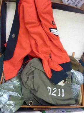


Lot 597
Medals-A World War I Family Group comprising: British War Medal, 1914-1915 Star and Victory Medal posthumously awarded to Private Leonard Hingley, Army Cyclist Corps together with death plaque, a copy of Commemoration, three dog tags and cap badge. British War Medal awarded to Private Frank Hingley together with death plaque and copy of Record of Commemoration and British War Medal and Victory Medal awarded to Private William Hingley, Northumberland Fusiliers also a Durham National Reserve badge, a World War I commemorative medal and copies of a family photograph and census sheet relating to the family


Lot 118
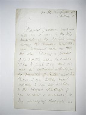
FLORENCE NIGHTINGALE - a handwritten letter from Florence Nightingale, from 30 Old Burlington Street, London. A letter of reference for Margaret Goodman who had served with her in the War Hospitals of the British Army during the Crimean Expedition. Double sided, signed at the end. Florence Nightingale is recorded in the 1861 census as living at the Burlington Hotel, 30 Old Burlington St. London ++a little faded and with some pin holes at the top


Lot 238
2nd World War Medal Group to 5612621 W.O.II A Cornish R.E. Includes: WW2 star, Africa star with 8th army clasp, defence and war medals, general service medal with `Palestine` clasp and army long service and good conduct medal with regular army bar (total of 6). Overall good condition but with some fading to the ribbons.


Lot 263
A fine DSO Boer war group to Brigadier General C.F. Watson C.M.G. D.S.O. The Queens Royal West Surrey regiment. CMG. DSO (1901 Edward crown), QSA medal with clasps - care colony, laings nek, transvaal, relief of ladysmith, orange free state, tugela heights. KSA medal with clasps - South Africa 1901 and 1902. 1914 star with clasp, war medal, victory medal with M.I.D., IGS with clasp Burma 1930-32, French legion of honour. (total 9), in a spink display case. Medals excellent condition, some ribbons faded. Together with a superb framed photo of Captain Watson taken before his wedding in January 1906 wearing full dress uniform and wearing his DSO and Boer war medals. Also included are 2 point-to-point programmes from 1914 showing Captain Watson entered for a silver cup race on his horses called `Nancy`. He won! Charles Fredric Watson was commissioned 2nd Lieutenant on 22/1/1886 and fought in the Boer war with the Queens Royal West Surrey regiment. He was mentioned in despatches and awarded the D.S.O. (London Gazette 27/9/01). He went to France with the B.E.F. soon after the outbreak of World War I in 1914 and by September was in action. He was wounded and mentioned in despatches. Following a series of promotions on the staff he was sent to the Palestine campaign to command the 180th brigade, 60th division. He was the first officer to enter Jerusalem. At some point in the campaign he was wounded again. In 1922 he commanded the 2nd BN, the Royal Worcestershire regiment. This was followed by a period on half pay until selected as Brigadier General in command of the Rangoon brigade. He retired from the army in 1931 and died on 12/7/1948. From the family.

Lot 265
Somerset Rifles officers or Senior NCOs grey cloth Shako, complete with black ball tuft. Blackened badge to the front (45th Somersetshire Rifles) and small blackened mask at rear. It is trimmed with black piping etc. and there is red silk lining and leather sweat band velvet trimmed at the peak. Makers name is in gilt `T Gandy, Army Tailor, George Street, Bath`. Some minor crazing to the patent leather peak and scuff marks. Moth damage is in one place on top. Otherwise very good condition for age. Complete with its original tin case. Nb. The 45th were based in the Wells area.


Lot 112
OO gauge, seven Lima diesel/electric locomotives: consists of 205129 Class 42 Bo-Bo `Rapid D838` wrong box; 5x Class 47 Co-Co (one F repainted to `Merddin Emrys 47145`, Railfreight `Diamond Jubilee 47365` wrong box, 204818 `Old Oak Common 47701`, 205089 `Captain Peter Manisty RN 47833/D1962 Lt. Ed. Cert. No 814/850, 204823 `The Royal Army Ordnance Corps 47972` Lt. Ed. Cert. No 492/850); Class 59 Co-Co `Yeoman Endeavor 59001`. All appear G/VG unless noted, boxed. (7).

Lot 356
Palitoy Action Man Action Soldier, c.1960s: with hard painted head, wears tunic, trousers, boots and metal ID tag, includes Action Soldier Army Manual. In G/VG condition, uniform faded, contained in F box missing flaps at one end. Together with a selection of Action Man accessories including Astronaut outfit in G condition.

Lot 677
Ten Quality Products `Buddy L` preschool toy vehicles: consists of 5273 Kenworth Aerodyne Space Shuttle Carrier; 2544 Mack Brute Haulers with Space Shuttle; 554 3-stage Missile Carrier; 593 Searchlight Trailer; 544 Space Shuttle Carrier; 558 Command Defense Trailer; 595 Assault Chopper Transporter; 308 Army Tank; 5221 Army Jeep; 5210 Special Forces Troop Transport. All appear G/VG in F/G boxes. (10)


Lot 158
Colonial Mid-Atlantic (A Map of the Country round Philadelphia Including Part of New Jersey New York Staten Island & Long Island), Anon., Gentleman`s Magazine, Edinburgh, [1776]. 8.5 x 7”. (BW) This Revolutionary Warperiod map encompasses the area of Eastern Pennsylvania through Long Island and south to include Chesapeake Bay. The map was issued to illustrate the British Army`s objective of defeating Gen. Washington at Long Island and then to march to Philadelphia and put a quick end to the conflict. It is centered on Philadelphia, includes most of New Jersey, Delaware, Long Island, southwest Pennsylvania, northern Chesapeake Bay and the greater New York City area. The southern New Jersey coast is labeled Sandy Barren Deserts. The map is filled with interesting features including Indian villages, towns and cities, ferries, and roads (including the distances between towns). Adorned with a simple compass rose. Ref: Jolly GENT-247; Phillips (M) p.699; Klein G76.6; Sellers and Van Ee 1041. Issued folding, with light offsetting and a few short fold separations in blank margins, closed on verso with archival tape. (+B)

Lot 164
Mid-Atlantic United States (Theatre des Operations des Armees Americaine et Britanique en 1776 et 1777, depuis la Riviere de Rariton, dans le Jersey de L`Est, jusqu a la tete de L`Elk Dans le Maryland), Marshall, Vie de George Washington, Philadelphia, ca. 1807. 15 x 9.8”. (BW) Detailed map of the field of operations in 1776 and 1777 centered on Philadelphia, and including Princeton, Wilmington, Burlington, etc. with positions of English and American forces during the Revolutionary War. Map depicts from the Rariton River (New Brunswick) in New Jersey to Elk Head (Elkton) in Maryland with great detail of the army positions, forts, roads, town and taverns. This map appeared in the French edition of Marshall`s Life of Washington. (A)

Lot 169
Colonial Southeast (A New and Accurate Map of North Carolina, and Part of South Carolina, with the Field of Battle between Earl Cornwallis and General Gates), Lodge, Political Magazine, London, 1780. 15 x 10.8”. (BW) This scarce map of the Carolinas, published during the American Revolution, is apparently based on Henry Mouzon`s 1778 foundation map of the region. It is filled with topographical notes and the locations of important plantations, court houses, meeting houses, swamps, and chapels. This map illustrates the region involved in the southern theater of the war. After General Clinton seized Charleston in May of 1780, the British began a campaign into the Carolinas in pursuit of the remnants of the Continental Army. The map illustrates the Battle of Camden in August, 1780, where the American General Gates was defeated by British General Cornwallis. Ref: Jolly no.POL-16. Issued folding, now pressed with light soiling. There are several fold separations, tears, extraneous creases and small holes along left-hand fold that have all been closed on verso with archival materials, with minute loss of image. (B)
![Florida, Georgia ([Lot of 2] Florida. Nach den besten Quellen bearbeitet [and] Neueste Karte von Georgia mit seinen Strassen,](http://lot-images.atgmedia.com/SR/36385/2862480/176-2012510161833_468x382.jpg)
Lot 176
Florida, Georgia ([Lot of 2] Florida. Nach den besten Quellen bearbeitet [and] Neueste Karte von Georgia mit seinen Strassen, Eisenbahnen und Entsernungen), Meyer, Hand Atlas, 1845. 11.5 x 14.5”. (HC) A. Florida. Nach den besten Quellen bearbeitet. This is an interesting map of the state of Florida based on the important Mitchell series showing towns, forts, roads, canals, major rivers and lakes. There are references to forts, battlefields, and routes used by the Army during the Seminole War. There are also three inset maps detailing Pensacola, Tallahassee, and St. Augustine. Water routes from St. Augustine and Pensacola to various ports are described along the upper and lower margins. B. Neueste Karte von Georgia mit seimen Strassen, Eisenbahnen und Entsernungen. This is the German edition of the Tanner/Mitchell Georgia map from the New Universal Atlas, with a German title but using English place names. Along the bottom of the map are the steamboat routes from Savannah to Augusta and Charleston (here spelled Carleston). The map shows early county development along with gold mines, canals, trails, roads and railroads. It has a remarkable twelve distance scales. Florida has a few faint spots with light toning along sheet edges Georgia is lightly toned with a few edge tears confined to the blank margins that are closed on verso with archival tape. (+B)
![Southwestern United States ([Lot of 2] Military Reconnaissance of the Arkansas, Rio del Norte and Rio Gila… [and] Notes](http://lot-images.atgmedia.com/SR/36385/2862480/199-201251016208_468x382.jpg)
Lot 199
Southwestern United States ([Lot of 2] Military Reconnaissance of the Arkansas, Rio del Norte and Rio Gila… [and] Notes of a Military Reconnaissance, from Fort Leavenworth, in Missouri, to San Diego, in California…), Emory, Washington D.C., 1847-48. 67 x 30”. (BW) A) Military Reconnaissance of the Arkansas, Rio del Norte and Rio Gila, by W.H. Emory, dated 1847, (67" x 30"). An important Mexican-American War period map that shows the route of Col. Kearny and his Army of the West as they traveled from Ft. Leavenworth to Los Angeles via Santa Fe and San Diego. Wheat states that the map was an important milestone in the cartographic development and accurate determination of the geography of the West. Published in Senate Doc no.7, 30th Cong., 1st Session. A large map printed on three sheets, joined as issued. Ref: Wheat [TMW] no.544. Condition: Scattered foxing with numerous short splits at fold intersections and a few light damp stains at left. Folds into attractive contemporary hard blue covers with ribbon tie closures. (C+) B) Notes of a Military Reconnaissance, from Fort Leavenworth, in Missouri, to San Diego, in California..., by W. H. Emory, published 1848, (6" x 9"). This is the Senate edition of Emory`s important report documenting the 1846-1847 journey of the advanced guard of General Kearny`s Army of The West. Emory was Brevet Major of the Corps of Topographical Engineers. Emory`s reports are enjoyable reads and this is no different, with passages such as "I stopped in the little town of Isoletta, to visit my friend, the accolade, who has the reputation, Indian though he be, of being the most honest man and best maker of brandy in the territory." The report summarizes the activity of the U.S. Army of the West after the capture of New Mexico with important early views of the region. It is illustrated with 26 lithographed views, three battle maps, and 14 botanical plates. The important view of San Diego is present. The battle plans are: Sketch of the Actions fought at San Pasqual in Upper California…; Sketch of the Passage of the Rio San Gabriel...; and Sketch of the Battle of Los Angeles Upper California. Fought between the Americans and Mexicans Jany. 9th, 1847. Complete with the two page report (Appendix No. 7) by P. St. Geo. Cooke, Major 2d Dragoons. Printed by Wendell and Van Benthuysen. This is the second edition printed, and thus did not originally contain the large folding map by Emory, which was included in the first and third editions. 416 pages + plates. 8vo, hardbound in brown cloth covers with original paper label on spine. Ref: Wagner & Camp no.148:2. Condition: Moderate to heavy foxing throughout the text with the plates showing only light scattered foxing. Label and covers are very worn. (B) See descriptions. ()

Lot 206
Southwestern United States (Report of the Exploring Expedition from Santa Fe, New Mexico, to the Junction of the Green Rivers of the Great Colorado of the West, in 1859…), Macomb, Washington D.C., 1876. 9.5 x 12”. (PC) This important report was produced in 1860 but not issued until 1876 due to the Civil War. Included is the very rare Map of Explorations and Surveys in New Mexico and Utah… (34 x 28.5"), which is considered by Wheat to be a landmark in the mapping of the region and "one of the most beautiful maps every published by the Army." According to Wheat there are several reasons for its importance. First, it is the first to show a trail to the junction of the Green and Grand Rivers. Second, he praises the map for its depiction of numerous routes of other explorers. Finally, it demonstrates the culmination of the process developed by Egloffstein to convey the idea of altitude. The process used a combination of extremely fine lines and applying acid to the plate for varying times, thus giving the map a remarkable 3-dimensional realism unmatched in the period. It is also the first to correctly establish the relationship between the San Juan and Colorado Rivers. The map covers Arizona, Utah, New Mexico and about 30% of Colorado. This highly sought after report is complete with eleven black and white engravings and eleven chromolithograph prints, and also features "Descriptions of the Cretaceous fossils collected on the San Juan Exploring Expedition under Capt. J. N. Macomb, U.S. Engineers." by F. B. Meek. 4to. Complete. Hardbound in brown cloth with gilt title on spine. Ref: Wheat (TMW) no.983. There are a number of fold separations and splits at fold intersections, some of which have been repaired on verso with archival material, including a clean 5" fold separation crossing the title that has not been closed. There is some light toning along folds, minor offsetting, and a few small spots. Text and plates are very good with some light toning and occasional small spots. The covers and spine are worn with the front cover loose and almost detached. The binding is almost perished with some pages separated from text block. (B)
![Tennessee, Civil War ([Lot of 9 - Civil War in Tennessee]), Ruger, History of the Army of the Cumberland, [1875]. x ”.](http://lot-images.atgmedia.com/SR/36385/2862480/252-2012510162354_468x382.jpg)
Lot 252
Tennessee, Civil War ([Lot of 9 - Civil War in Tennessee]), Ruger, History of the Army of the Cumberland, [1875]. x ”. (PC) Included are nine maps by Edward Ruger illustrating the various Civil War battles in Tennessee from the atlas of Van Horne`s "History of the Army of the Cumberland." Ruger worked for the Topographical Engineers and had access to the War Department maps and plans, which he used in the production of these finely detailed and well engraved maps. Each shows highly detailed troop actions and movements with color overprinting. Published by Robert Clarke & Co., and printed by the Krebs Lithographing Co., Cincinnati. A. Map Exhibiting the Campaigns of the Army of the Cumberland…, (17.3" x 14.5"). Condition: Two tiny splits at fold intersections and a 0.5" edge tear that has been repaired on verso with archival tape.. (B+) B. Map Exhibiting the Chattanooga & East Tennessee Campaigns in Conjunction, (18" x 16.5"). Condition: There are 2" and 5" fold separations that have been partially repaired on verso with archival tape. Binding trim at upper right. (B) C. Map of the Field of Shiloh…, (5" x 8.3"). Condition: (A). D. Map of the Battlefields in Front of Nashville, (8.8" x 8"). Condition: (A). E. Battlefield of Chattanooga With The Operations of the National Forces… , (8" x 9.5"). Condition: Binding trim at lower left. (B+) F. Battlefield in Front of Franklin, Tenn., (5" x 8"). Condition: (A). G. Map of the Battlefield of Stone River, (5" x 8.1"). Condition: (A). H. Map of the Battle of Chickamauga, (8" x 5"). Condition: (A). I. Map of the Country Between Monteret, Tenn. And Corith, Miss. … , (6.5" x 8"). Condition: (A). See descriptions. Larger sheets are issued folding. ()

Lot 268
Missouri (No. 3 Map of the Harbor of St. Louis, Mississippi River), U.S. Army, Senate Doc. no.139, 25th Congress, 2nd Session, Washington D.C., 1837. 42 x 16.6”. (BW) Robert E. Lee surveyed and produced three maps of the Mississippi River in 1837. This one, joined on two sheets, covers that portion of the river in the vicinity of St. Louis and includes a street plat of the city (with some streets named). It locates stone quarries, lime kilns, Indian mounds, etc. The islands of Cascarot (partial), Bloody, Duncan`s and part of Cahoe are shown. There are proposed dikes and revetments to improve the harbor. A cross-section of a typical dyke is illustrated. Finely drawn by Lee, it contains very good detail of the area. Just a hint of offsetting and toning, else fine. (A)
![New Mexico (Map of the Territory of New Mexico, made by order of Brig. Gen. S. W. Kearney… [with] Report of Lieut. J. W](http://lot-images.atgmedia.com/SR/36385/2862480/275-2012510162537_468x382.jpg)
Lot 275
New Mexico (Map of the Territory of New Mexico, made by order of Brig. Gen. S. W. Kearney… [with] Report of Lieut. J. W. Abert, of his Examination of New Mexico, in the Years 1846-47), Abert & Peck, HR. Ex. Doc. 41, 30th Congress, 1st Session, Washington D.C., 1846-47. 19.5 x 25”. (BW) During the War with Mexico, Lieutenants Abert and Peck were enroute to the Pacific with Lieut. Emory as part of General Kearny`s Army of the West, but the two were left behind due to illness. They took the opportunity to continue their survey efforts earlier started on Fremont`s third expedition. The resulting map is a very detailed look at the Rio Grande Valley and some adjacent areas including the pueblos of Laguna and Acoma. This important map, illustrated in Wheat, is roughly centered on Santa Fe. It details the territory along the Rio Grande from above Taos south to well below Socorro and San Antonio to the ruins at Valverde. Excellent detail of the topography and watershed to either side of the river with the mountains shown via hachure. Filled with place names including numerous villages and small towns, and the Comanche Route from Arkansas. Blank areas to the west and north are labeled Navajo Indians and Utah Indians. This map was issued with Emory`s Notes of a Military Reconnaissance in 1848. 10,000 copies were produced for this House of Representatives edition. This lot includes the unbound Abert`s report which includes 24 plates. Unbound, title page, pages 417 - 548, 24 plates, 7.3 X 4.3" The plates include: Santa Fe; O-CUM-WHO-WUST; Old Bark`s Son AH-MAH-NAH-CO and Squaw; Las Cumbres Espanolas; San Miguel; Ruins of Pecos; The Gold Mountains near Tuerto; Fort Marcy and the Parraquia - Santa Fe; San Felippe; Pueblo de Santo Domingo; Pueblo de Santa Ana; Moquino; Acoma, No. 1; Acoma, No. 2; Acoma, No. 3; View near Rito; El Canon Inferno; Ruins of Abo; Bosque de Apache; Valverde, and four more. Historical and important map complete with its report. Ref: Wheat (TMW) 532; Wagner-Camp-Becker 148.5; Howes E145 Map has been backed with tissue to reinforce and repair a few minor tears and splits along the folds. There is toning along the folds where cello tape, now removed, had previously reinforced the map. Report is disbound with the first few pages loose from text block. Map and report are housed in an attractive, contemporary brown clamshell folder. (+C)

Lot 296
Wilmington, North Carolina (Cape Fear River, with the Counties Adjacent, and the Towns of Brunswick and Wilmington, against which Lord Cornwallis, Detached Part of his Army, the 17th. of January Last), Lodge, Political Magazine, London, 1781. 7 x 9.5”. (BW) This interesting and scarce map depicts the Cape Fear River vicinity near the close of the Revolutionary War. Wilmington was captured by the British in 1781 and plantations in the Cape Fear area were ransacked. The map shows numerous locations including Mount Misery, Wilmington, Brunswick and Lockwoods Folly with notations of their distance from Charlestown, from which General Cornwallis launched his attack on the region. Fort Johnson, which had been destroyed at the outbreak of the war, is also shown. Published by John Bew. Ref: Jolly no.POL-22; Sellers & Van Ee no.1512. Issued folding with a few faint spots. (+B)

Lot 318
Virginia, Civil War (Map of the Vicinity of Petersburg. Taken from Surveys Made by Order of Maj. Gen. J. F. Gilmer, Chief-Engineer, C. S. A.), Gilmer, Life and Campaigns of General Robert E. Lee, Philadelphia, [1866]. 12 x 18”. (BW) This is an uncommon map by Major General Gilmer, who was in charge of providing detailed maps for use by the Confederate Army. It is a good example of the painstaking detail his surveyors gathered, covering an area 15 miles by 22 miles wide, and shows numerous fortifications, towns, railroads, and locations of residents. Petersburg is located along the Appomattox River, and was the scene of the last of the great battles of the Civil War. This edition was copied from Gilmer’s original and lithographed by H. L. Penfield of New York. There is some light, uneven toning and a tiny pinhole located on the lower fold. The top margin is narrow but adequate for framing. Issued folding on thin banknote paper. (+B)
Lot 808
Africa (Afrique), Levasseur, Atlas Universel Illustre, Paris, ca. 1845. 17.5 x 12”. (HC) This decorative 19th century map of the continent shows the colonial possessions and major tribal kingdoms. The interior is mostly void of detail, with the exception of the mythical Monts de la Lune, or Mountains of the Moon in the center of the continent. These legendary mountains were long thought to be the source for the Nile, dating back to Ptolemy. Stanley traced a fluvial connection from the Nile back to a mysterious snowy mountain range in Central Africa in 1888, dubbing the mountains Ruwenzori and proclaiming them the Nile source that Ptolemy described. The map is surrounded by steel-engraved scenes by Raimond Bonheur including the pyramids, wild animals, natives, the French army in Algeria and vignettes of Alexandria, Cairo, and Algiers. The map also includes population statistics from the major countries and French text describing the continent and the engravings surrounding the map. Minor foxing confined to the blank margins. (A)

Lot 900
Atlases (New Universal Atlas Containing Maps of the Various Empires, Kingdoms, States and Republics of the World…), Thomas, Cowperthwait & Co., Philadelphia, 1854. 14 x 17.5”. (HC) The title continues "With a special map of each of the United States, Plans of Cities &c. Comprehended in seventy five sheets and forming a series of one hundred and twenty two maps plans and sections." This famous and highly sought-after atlas is complete with 75 map sheets of the world, North America and the other continents, Oceanica, the United States and its territories, and numerous city plans. The atlas concentrates mainly on the American continents, and features many important and desirable maps. The map of Texas is one of the most influential atlas maps of the period. It depicts the new boundaries that were determined by the Compromise of 1850. The organized counties extend only to Cooke in the north and Kinney in the southwest. The western edge of the frontier is marked with a line of army forts separating the settled region from the vast area noted as rolling table lands and desolate plains Destitute of Timber. This area is largely the range of Apache, Kiowa, Comanche and Lipan Indians. Wagon roads, springs, and trails are identified, including the Comanche War Trail, Connelly`s Trail and the Emigrant`s Route. Tiny flags locate important battlefields in both the Texas war for independence and the Mexican American war. Descriptive explanations and notes make this map an interesting study. A table provides statistics according to the Census of 1850 including the population by ethnic groups, e.g. "Free Colored males" is given as 171. There are insets of Northern Texas, noting the northern boundary at Lat. 36 30`, as resolved in the Compromise of 1850, and the vicinity of Galveston City. The spectacular map of the West has a large Oregon territory extending to the Continental Divide, the huge Utah Territory extends from California to Indian Territory, and New Mexico occupies all of the Southwest with a pre-Gadsden Purchase border. The double-page map of the United States features the same borders in the West, plus a large inset map of the Gold Region of California. The map of Minnesota features the large territories of Pembina and Blue Earth extending to the Missouri River. The frontispiece is a hand colored, engraved diagram showing the lengths of rivers and heights of mountains. The title page includes a fine, early chromolithographic image by P.S. Duval titled First Landing of Columbus in the New World, which shows Columbus and his crew giving thanks to God for their safe journey. Folio, frontis, chromolithographed pictorial title page depicting Columbus` arrival in the New World, table of contents printed in red and gilt color, 74 map sheets comprising 70 single-page maps, 3 double-page maps (US, New York and Europe) and the thematic plate. Bound in half red leather over marbled paper boards. Red leather label on front cover with gilt title and design. Published by Thomas, Cowperthwait, & Co. No. 253 Market Street, Philadelphia. This is an increasingly difficult to find atlas complete with all its maps. Maps have original color and are mostly in near fine condition with some in very good condition with occasional light foxing. Toning is primarily confined to blank margins, although a few maps have overall light toning. The binding is very loose and the spine is missing. The covers are detached and show moderate wear and rubbing. This example would benefit greatly from professional rebinding. (+B)

Lot 912
Exploration and Surveys (Exploration of the Red River of Louisiana in the Year 1852), Marcy, Sen. Exec. Doc. 54, 32nd Congress, 2nd Sess., Washington D.C., 1853. 6.3 x 9.3”. (BW) The U.S. Army expedition commanded by Captain Marcy was the first to discover the source of the Red River. His report abounds in topographical and geographical detail with attention also paid to the customs of the native people in the southern plains. It includes an impressive scope of data, including meteorological and natural history information, with emphasis on geology, paleontology, reptiles, fish, insects and botanicals. Sixty-four beautifully lithographed plates are included, as well as a hand-colored fold-out geological chart of the region. The two folding maps accompanying the report are not present. Hardbound in embossed green cloth with gilt title on spine. 320 pp. 8vo. Ref: Wagner-Camp no.226.1 Scattered foxing and toning throughout. Covers and spine are bumped and worn, and the hinges are starting. (B)


Lot 721
Maxwell (W.H.). Life of Field-Marshal His Grace the Duke of Wellington, 3 vols., 4th ed., 1845, half-title, eng. frontis., and additional eng. title to each vol., eng. plts., plans, etc., orig. gilt- and blind-decorated red cloth, a little rubbed and lightly soiled (generally in good condition), together with Mackinnon (Colonel Daniel), Origin and Services of the Coldstream Guards, 2 vols., 1st ed., 1833, half title to each vol., b&w plts., occ. light marginal spotting, orig. cloth, faded to spine and edges, and somewhat soiled, joints frayed, with rear cover to second vol. near-det., plus Oman (Charles), A History of the Peninsular War, 4 vols., 1902-11, folding maps, b&w plts., etc., bookplate of Charles Corkran to front endpaper of each vol., t.e.g., orig. uniform red cloth gilt, rubbed and spines lightly faded, and others on the Peninsular War and similar, including Alexander Innes Shand, Wellington`s Lieutenants, 1902, F. Loraine Petre, Napoleon`s Campaign in Poland 1806-7, pub. 1901, Rev. Herbert Randolph, Life of General Sir Robert Wilson, 2 vols., 1862, Report of a Committee Appointed by the Admiralty to Examine and Consider the Evidence Relating to the Tactics Employed by Nelson at the Battle of Trafalgar, pub. HMSO, 1913, Cecil C. P. Lawson, A History of the Uniforms of the British Army, 4 vols., mixed eds., 1961-66, etc., mostly 8vo. Ex libris Captain Michael Boyle, Irish Guards. (25)

Lot 722
Milne (Samuel). The Standards and Colours of the Army, from the Restoration, 1661, to the Introduction of the Territorial System, 1881, pub. Leeds, 1893, twenty-nine col. and b & w plts. (correct as list), EXTRA ILLUSTRATED with approx. thirty-five orig. watercolour drawings and a few pen and ink drawings, by D. Hastings Irwin, as well as a few related news cuttings, prints and manuscript notes, t.e.g., orig. cloth gilt, minor wear to extremities, 8vo. Limited edition 120/200. Ex libris D. Hastings Irwin (military historian) with his ownership signature on flyleaf. (1)

Lot 738
*India - Third Anglo-Maratha War. A group of fourteen autograph letters relating to the conflict and its aftermath, c. 1817-1820, many addressed to Lieutenant Colonel Doyle (military secretary to the Marquis of Hastings), the earliest dated letter (camp twelve miles between Mooltye & Beetool, 13th October 1817) from John Briggs, in part `... the delays that the troops have experienced this season have been owing principally to the total want of means for crossing rivers. The Manjissa (a contemptible stream) the Poona which empties itself into the Godavery equally is so insignificant as not to require boats in general but travels[??] have this year stopt detachments even without guns for three weeks and a month together. this is a subject that has attracted the notice of General Lionel Smith particularly... `, `... the Nabob Sullabut Kahn with 1200 foot and 1700 good horse joined us at a -; 400 of the former and 500 of the latter have been left to explore and defend if possible Gauilgur Range and the cavalry are to act in body on the plain if any small parties of Pindaris penetrate through them - the principal object to be attained by this will be the local information of passes and roads direct from Berar to the Hubudda which will facilitate our communication of much and by our current presence preclude the possibility of its again becoming the hiding place and rendezvous of all marauders who are either headed into them from the plains or who assembe to make inroads into them...`, other correspondence include W.J. Beason, F. Chamberlin, John Briggs and R.G. Mallory, the latter writes to Carroll (Camp near Jaulnah, 31st March 1818), `I promise to give you an account of the occurences of this campaign since the attack on Colonel Burr at Poona on the 5th November last with my own remarks on the operations of this division of the Deckan army... `, and later in the same letter `Instead of following the Peshwa and seizing the advantage of the difficult roads he had to pass we remained at Poona the 17th and 18th [November]. On the 19th we heard that part of the enemy`s guns which attempted to get through the Suttrage Ghaut were at our mercy. A detachment was sent out, took fourteen guns, killed all that endeavoured to defend them & captured jewels & property amounting to more than a Lakh. Some of our Light Company got the amount of 10,000 rupees in plunder of pearls then. Burr marched[??] on the 23rd via the Bore Ghaut and had a trifling cavalry affair near the Neera river with the Chechor or Kinchore Rajahs divisions but they`d retreated and passed the Salphe Ghaut, which we also ascended on the 28th. Goklh endeavoured to oppose us at the head of the pass but, after sustaining some loss, he was forced to retreat... `, this letter with cross writing, mostly two to four pages and some with integral address panels or envelope, 4to, each with typed transcription, together with ten related letters without transcriptions and a group of approx forty other 19th-c. military and naval autograph letters and manuscript documents, many relating to India, including twelve from Gough to Daisy and other family members in London and Ireland, c. 1883, twelve letters to and from Captain George Egerton RN to his wife and others, two written onboard HMS St. George, dated c. 1876-95, various sizes, some with envelopes, plus a much later typed letter signed (3rd August 1965) from Mountbatten of Burma. The Third Anglo-Muratha War (1817-1818) was the final and decisive conflict between the British East India Company and the Muratha Empire in India. The war left the Company in control of most of India. The invasion by 110,400 British East India Company troops was led by Governor General Hastings, supported by General Thomas Hislop. The latter wrote a book of these events titled `Summary of the Muratha and Pindarree Campaign During 1817, 1818, and 1819, Under Direction of the Marquis of Hastings` (1820). (a folder)
-
116692 item(s)/page