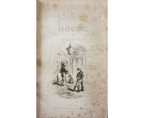

Dickens (Charles). Bleak House, 1st edition, London: Bradbury Evans, 1853, monochrome illustrations by H. K. Browne later endpapers, some spotting & toning, later plum half morocco retaining contemporary morocco spine, spine & hinges slight rubbed, 8vo, together with other 18th-century to modern miscellaneous literature, including A Cyclopedia of Agriculture, Practical and Scientific;..., 2 volumes, by John C. Morton, London: Blackie And Son, 1856, contemporary uniform gilt decorated half calf, 8vo, The History of Pendennis..., 2 volumes, London: Bradbury Evans, 1849, The Virginians. A Tale of the Last Century, 2 volumes, London: Bradbury Evans, 1858, both by William Makepeace Thackeray, 8vo, some leather bindings, mostly original cloth, G/VG, 8vo/folioQTY: (6 shelves )
We found 137173 price guide item(s) matching your search
There are 137173 lots that match your search criteria. Subscribe now to get instant access to the full price guide service.
Click here to subscribe- List
- Grid
-
137173 item(s)/page
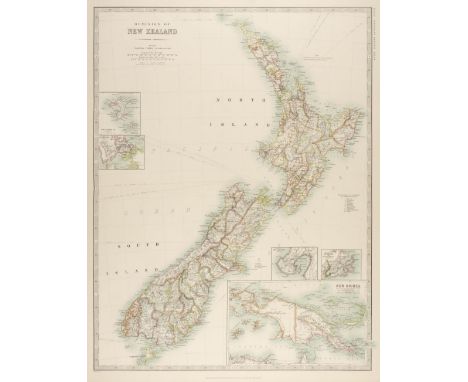
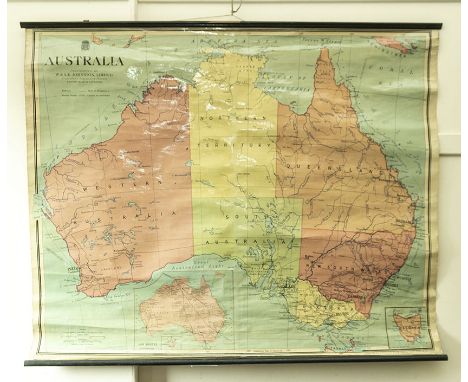
Australasia. Johnston (W. & A. K.). Dominion of New Zealand, circa 1880, colour lithographic map, inset maps of Chatham island, Environs of Aukland, Environs of Wellington, Environs of Dunedin and New Guinea, 585 x 450 mm, together with Vandermaelen (Phillipe Marie Guillaume). Iles des Amis, circa 1827, engraved map with contemporary outline colouring, inset descriptive text in French, 480 x 555 mm, with Walker (J. & C.). Western Australia Containing the Settlement of Swan River and King George's Sound [and] Van Diemen Island, 1833, two engraved maps on one sheet (as published), contemporary outline colouring, 320 x 405 mm, plus Bonne (Rigobert). Isles de la Reine Charlotte [and] Carte de la Terre Van-Diemen, Paris, circa 1787, two hand-coloured engraved maps, slight spotting, each approximately 250 x 360 mm, and another seven maps similar, including examples by or after Cook, Morse and Walker, plus a small late 18th century uncoloured engraved portrait of Captain James Cook, 175 x 110 mmQTY: (13)
![Collins (Capt. Greenville). Fowey & Mounts Bay..., [1693 -1779], hand coloured engraved sea chart, inset map of Mount's B](https://cdn.globalauctionplatform.com/4839b208-d815-4d8e-b853-aeeb010dbac6/8148bd5a-f165-469d-8a9c-aeec0114a347/468x382.jpg)
Collins (Capt. Greenville). Fowey & Mounts Bay..., [1693 -1779], hand coloured engraved sea chart, inset map of Mount's Bay, elaborate cartouche, compass roses and numerous rhumb lines, 450 x 565 mm, together with A Large Draught of the Downes..., hand coloured engraved sea chart, 430 x 535 mm, with a chart of Rye and its harbour, 450 x 290 mm, with Mercator (Gerard). Zelandia Comitatus, circa 1600, hand-coloured engraved map, large strapwork cartouche, 345 x 490 mm, French text on verso, plus Johnston (A. K.). West India Islands, circa 1850, engraved map with contemporary outline colouring, some marginal fraying, slight toning to the central fold, 505 x 605 mm, and Johnston (Keith). Ireland, circa 1870, engraved map with contemporary outline colouring, 430 x 340 mm, with two other maps similarQTY: (8)
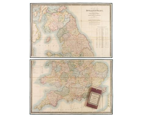
Folding Maps. A collection of nine folding maps, mostly 19th century, engraved and lithographic regional and touring maps, including Wyld (James). A New Map of England & Wales Projected upon the Trigonometrical Operations made for the General Survey of the Kingdom, James Wyld (Successor to Mr Faden), 1st. January 1830, large engraved map with bright contemporary hand colouring, sectionalised and laid on linen on two sheets, calligraphic title, table of the altitudes of the principal mountains and table of explanation, slight offsetting, edged in green silk, each sheet approximately 625 x 950 mm, paper endpapers, contained in a contemporary cloth slipcase with a publisher's printed label to the upper cover, together with Wallis (John). Wallis's New and Correct Map of the Post Roads of England & Wales, 1790, engraved map with contemporary outline colouring, sectionalised and laid on hessian, some staining, small holes where old folds cross, old manuscript ownership signature to the upper margin, 555 x 470 mm, contained in a contemporary marbled card slipcase with publisher's printed label to the upper cover with an additional manuscript ownership signature, heavily worn and frayed, with Cassell, Petter, Galpin & Co. (publishers). Map of Greater London, printed by Edward Stanford, circa 1890, folding lithographic map laid on linen, slight spotting and staining, 740 x 630 mm, contemporary cloth boards with the gilt letters 'J. H. L.' to the upper siding, plus Johnston (W. & A. K. publishers). Northern Part of Ross and Cromarty Shires, Compiled from Actual Surveys by John Craig, Glasgow, circa 1850, engraved map with contemporary outline colouring, sectionalised and laid on linen, inset map of Lewis, 1020 x 700 mm, contained in a contemporary blind-stamped cloth slipcase, and Brion de la Tour (Louis). Cartes des Postes D' Allemagne et des États Voisins..., Paris, 1791, engraved map with contemporary outline colouring, sectionalised and laid on linen, edged with pink linen, 730 x 1060 mm, two string ties in the upper corners, with another four folding maps, including examples by or after Ordnance Survey, Foley. Headley and Dufourcet, various sizes and condition, with Lewis (Samuel). A Topographical Dictionary of England..., 1831, folding engraved map of England and Wales and forty (only) uncoloured engraved county maps (including 10 folding), bookplate of Earl Granville, contemporary half gilt with gilt decorated spine, upper board detached, worn at extremities, 4to, plus Taylor (A. E.). Twenty-five City Plans, circa 1930, uncoloured photolithographic plans with English text below and on the verso of each map, map size approximately 120 x 180 mm, and Blomfield (Ezekiel). Lectures on the Philosophy of History..., 1819, printed title, advertisement and contents list, twelve (complete as list) engraved hemispherical maps with contemporary hand-colouring, partially uncut, slight spotting throughout, contemporary boards, 4to, together with Kent. Porcelain plate, possibly Coalport, circa 1880, colour transfer design featuring a map of the county of Kent, on a white background with a gilt and floriate rim, 225 mm diameter, and Treen. Spooled Length of Ribbon, circa 1880, yellow ribbon contained between two wooden circular discs, one disc painted, the other with an uncoloured circular lithographic map centred on Tunbridge Wells, diameter 55 mm, with a vellum indenture dated 1690, with one red wax seal and a small attached simple manuscript map, overall size 650 x 750 mmQTY: (39)
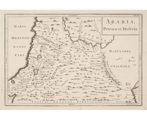
Middle East. A collection of approximately 42 maps, 18th & 19th century, engraved maps of Peria, Arabia, Palestine, Syria, Turkey and Asia Minor, including examples by or after De Vaugondy, Wilkinson, S. D. U. K., Cellarius, Brué, Rapkin, Gellatly and Radfeld, some duplicates, together with four engravings of costume and genre scenes, various sizes and conditionQTY: (46)
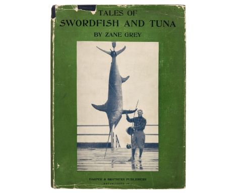
Grey (Zane). Tales of Swordfish and Tuna, 1st edition, New York and London: Harper & Brothers, 1927, code 'H-B' to title verso, half-tone illustrations by the author, top edge green, original blue cloth, dust jacket, a few small chips and tears, 4to, together with Tales of the Angler's Eldorado New Zealand, 1st edition, New York and London: Harper Brothers, 1926, code 'G-A' to title verso, half-tone illustrations, a few spots, contemporary presentation inscription at front, letter tipped-in at rear, original cloth, a little rubbed at spine ends, a few light marks, 4to, plus Tales of Fishing Virgin Seas, 1st edition, New York and London, 1925, code 'K-Z' to title verso, half-tone illustrations, original cloth, tiny close tear to spine, some light damps stains to spine and part of upper cover, 4to, with other fishing-related etc including Zane Grey's Tales of Lonely Trails, 1922, Tales of Southern Rivers, 1924 R.C. Grey Adventures of a Deep-Sea Angler, 1930 (rebound), The Best of Zane Grey. An Anthology compiled by Tom Fort, 1997, limited signed edition 60/750, and 3 Derrydale Press limited edition Zane Grey reprints, 1990-1993 QTY: (20)
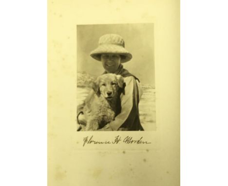
Morden (Florence H.). From the Notebook of Florence H. Morden, Concord, New Hampshire: Privately printed by William J. Morden, 1940, half-title, monochrome portrait frontispiece (lightly spotted), vignette illustrations in red by Francis Lee Jaques, original cream quarter paper, cloth sides, lightly toned to spine and boards, 4toQTY: (1)NOTE:Number 91 of an unspecified limited edition. Designed by William K. Wilson and printed at the Rumford Press of Concord, New Hampshire.
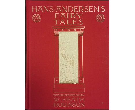
Folio Society. Hans Andersen's Fairy Tales, illustrated by W. Heath Robinson, 1995, Clarissa, Or the History of a Young Lady..., 2 volumes, by Samuel Richardson, 1991, The Mapp And Lucia Novels, by E. F. Benson, 6 volumes, 1994, The Travels of Marco Polo, 3rd impression, 1973, The Father Brown Stories, 2 volumes, by G. K. Chesterton, 1996, together with 17 further volumes of Folio Society publications, all original cloth in slipcases, 8voQTY: (29)
A GORDON HIGHLANDERS OFFICER'S SGIAN DUBH T. K. EBUTT, EDINBURGH 1968 of conventional form with carved basket weave back wood handle and oak leaf gallery and citrine above, the leather covered scabbard with simple mounts, single fullered blade with scalloped back edgeDimensions:Overall length 20.5cm
A COLLECTION OF UNBOXED AND ASSORTED MODERN DOCTOR WHO ACTION FIGURES AND ACCESSORIES, to include battery operated remote control K-9, not tested but appears largely complete and in good condition, damage to aerial on remote control, assorted Doctor and assistant figures, Cyberman, Daleks (missing items), figures not checked may be missing some small accessories
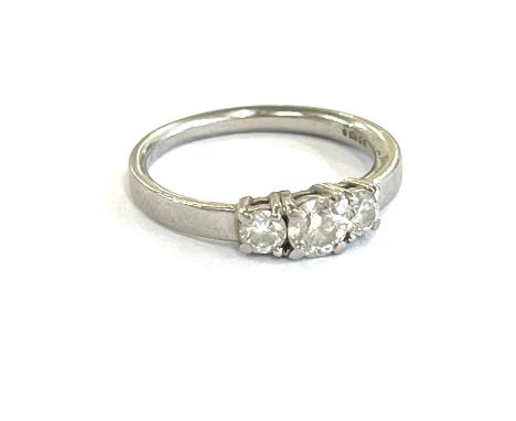
A silver ring set with pear shaped, rose cut Bharat blue sapphire, surrounded by white zircons, size J/K; a large flowerhead design, Bharat blue sapphire ring, size L/M; a matching pendant; A large oval green Grandidierite and diamond ring in silver setting, size N/O, 3.38gms ; a chrome diopside and Red Dragon pendant and silver ring

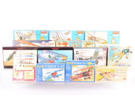
WWI Period Aircraft Postwar and Modern Kits, boxed examples, Merit Bristol Bulldog, Inpact Kits, Classic Fighter Series, P203 Bristol Bulldog, P202 Hawker Fury, P204 Fairey Flycatcher, Those Magnificent Men in Their Flying Machines, P102 Martin Handasyde, P105 Bristol Boxxite, Lindberg Line 534:98 Curtiss Jenny, K&B 11341:48 scale Fokker, Roden 1:72 scale 043 Bristol F.2B, Eduard 1:48 scale 8030 Alabtros, 8031 Werner Voss, Revell 1:72 scale 04116 Fokker, 4177 Fokker and Airfix carded and sealed 1:72 scale 01062 Sopwith Pup, all appear complete but unchecked, G-E, packaging G-E, (14)
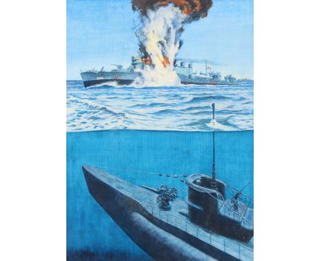
David K. Stone (American, 1922 - 2001) "USS Reuben James Sunk" Original Oil painting on Masonite. Signed lower right. Provenance: Collection of James A. Helzer (1946-2008), Founder of Unicover Corporation. This painting is the original painting which was published on the Republic of the Marshall Islands 30c USS Reuben James stamp issued October 31, 1991. On October 23, 1941, the USS Reuben James departed from Newfoundland to join five other American destroyers serving as convoy escorts for British merchant vessels. In the early morning hours of October 31, a surfaced German U-boat spotted the convoy and transmitted the news of its find to other subs in the area. Ordered to locate the source of the transmissions, the Reuben James increased speed and swerved to port -- just as the U-562 fired two torpedoes. One sped harmlessly aside; the other caught the venerable destroyer below the bridge, splitting the ship in half and igniting the forward magazine. The vessel sank within five minutes, and one hundred fifteen men -- two-thirds of its crew -- perished. The USS Reuben James thus became the first American warship lost in the Battle of the Atlantic. Image Size: 27 x 19.5 in. Overall Size: 27 x 24 in. Unframed. (B13152 / B13153)

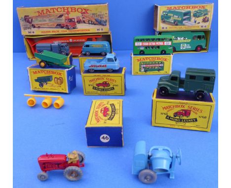
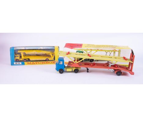
Seven boxed Matchbox die-cast models, two unboxed and one empty box.7 BOXED: Racing Car Transporter K-5; Car Transporter M-8; Volkswagen Mico Van 34;Trailer 51 (Lesney); Morris J2 Pick-up 60; Army Wireless Truck 68; Daimler Bus 74.2 UNBOXED: Cement Mixer and Blue Tractor.EMPTY BOX: Morris Minor 46;

-
137173 item(s)/page