We found 86082 price guide item(s) matching your search
There are 86082 lots that match your search criteria. Subscribe now to get instant access to the full price guide service.
Click here to subscribe- List
- Grid
-
86082 item(s)/page


Lot 660
George Staunton - An authentic account of An Embassy From the King of Great Britain to the Emperor of China with notices of Tristan d`Acuna, Amsterdam, Java, Sumatra, Cochin-China, the Atlas Folio Volume, issued 12th April 1796 by G. Nicol (first and only edition), paper size 43.5cm x 57.2cm in original boards, complete with 44 plates in VERY good condition *The first British Embassy to China, which was to lead to the foundation of Hong Kong as a British trading post. The plates are of special interest due to their depiction of subjects that very few Europeans had recorded or seen and the observations they gave the considerable technical, artistic and organisational advancement of the Chinese civilisation


Lot 633
SLEVOGT (MAX) REISEBILDER 12 AQUARELLE VON MAX SLEVOGT mounted colour plates of watercolours by Slevogt, cloth backed folio, Berlin, nd, eight others on Slevogt, including catalogues and a commemorative bronze medal, glazed and framed by Spink & Son Ltd (10) ++An interesting group forming a comprehensive survey of Slevogt`s oeuvre, in good condition. in the same German emigree family ownership since new

Lot 263
COMPOSITION AUX TITRES DE SOURATES Double folio de Coran sur lequel sont collés onze cartouches de titres de sourates du même Coran, découpés et montés sur les textes des deux pages. Les marges ont été décorées d`enluminures découpées dans le même Coran. Iran, XVIIe siècle. A 17th century Iran double paged Qur’an. DIM. de la double page : 24,5 x 31,5 cm (9 5⁄8 x 12 7⁄16 IN.)

Lot 45
Harry Kernoff RHA (1900-1974) PORTRAIT OF A LADY, 1928 chalk pastel on buff-coloured paper; (1); woodcuts; (2) signed and dated lower left 21 by 15in., 52.5 by 37.5cm. P Also with this lot are two woodcuts by Harry Kernoff, Breacadh an Lae or Dawn, 1929 and Profile of a Man in Shirt and Tie, 1931. Each signed and dated in the lower margin. Folio size of each title: 11.25 by 9in. and 8.5 by 6in., respectively.Breacadh an Lae or Dawn is illustrated in two books, the first, Woodcuts, Harry Kernoff, RHA a limited edition book (220 copies) published in Dublin, 1942 by Cahill and Company Ltd. The second title, Cap with Bells, Woodcuts by Harry Kernoff and Ink Washes by Noel Sheridan, by Coburn Britton, The Dolmen Press, Dublin 1959 (320 copies, illustrated p.26).
Lot 433
“Notes for the Press on the Occasion of a Visit to the Royal Airship Works, Cardington, 23rd August, 1928”. “Notes for the Press on the Occasion of a Visit to the Royal Airship Works, Cardington, 23rd August, 1928”,being 12 pages duplicated folio giving details of R-101’s construction, ground arrangements and meteorological arrangements. GC (final page detached, damp stain to lower l.h. corner throughout); together with “Report of the R101 Inquiry” being a photocopy of the report published by the H.M.S.O March 1931. (2).

Lot 184
CAVIAR À LA LOUCHE. – Manuscrit dactylographié de son roman, avec corrections de Mary Marquet et quelques-unes d’autres mains. Environ 200 pp. in-folio. Roman paru en 1978 (Paris, Grancher). Envoi autographe « Pour mon Philippe, cette 1ère "frappe" de mon premier roman. Sa Mamie. 15 janvier 1978 » Conclusion ajoutée de sa main : « ... Mais, avec vous, le temps passe vite. Il est l`heure de vous quitter. Adieu. Ne bougez pas... Attendez-moi... C`est merveilleux d`être attendue par quelqu`un !... »


![BAUDELAIRE (Charles)] : « Tristesses de la lune », « Le crépuscule du matin », « La servante au grand coeur ». 38 pp. in-foli](http://lot-images.atgmedia.com/SR/2242/2891785/190-2013118114026_468x382.jpg)
![[NOAILLES (Anna de)] : « Les campagnes », « La petite ville », « Paysage persan », « Solitude », «Paroles à la lune », « Les](http://lot-images.atgmedia.com/SR/2242/2891785/191-2013118114028_468x382.jpg)
Lot 191
[NOAILLES (Anna de)] : « Les campagnes », « La petite ville », « Paysage persan », « Solitude », «Paroles à la lune », « Les plaintes d`Ariane », « La nostalgie ». Longue citation par Mary Marquet de ses propres mémoires concernant Anna de Noailles. On joint également des copies de textes de MarcelineDESBORDES-VALMORE (« La couronne effeuillée ») et de Marie NOËL (« Chandeleur », « Chant de la Vierge Marie »). Soit environ 150 pp. in-folio.


Lot 618
Three boxes of assorted Mechanical, Electrical and Motor Vehicle related books to include three volumes "The Modern Motor Engineer", four volumes "The New Electrical Encyclopedia", together with various "Ford Fleet Efficiency Guides", folio bound, Workshop Manuals, Lister Operators Handbook, one volume "Stationery Steam Engines", "Beam Engines by Shire Publications, Haynes Owner Workshop Manuals, together with nine various vintage car colour prints, and a box of assorted bound folios to include "Know How", "Worlds Wild Places" Time Life books


Lot 9
Ptolemy/Mercator, 1704 Claudii Ptolemaei Tabulae Geographicae Orbis Terrarum Veteribus Cogniti This striking, classical title page is from Mercator`s edition of Ptolemy. It features two river gods in the foreground, and personifications of music, art, and learning are shown mapping the globe, while the angel of Fame trumpets above. Engraved by Jan van Vianen. Although Mercator is most renowned today for the projection he popularized and for first using the term "Atlas" for a collection of maps, he devoted much of his life to his Ptolemaic maps. This example is on a folio sized sheet and still attached to the table of contents for the atlas, published by Francois Halma and Guiljelmus van de Water. 9.3" W x 14.4" H Light soiling with a few small spots of foxing.

Lot 222
Carey & Lea, 1822 Geographical, Historical and Statistical Map of Kentucky The map is on a full folio sheet (22 x 17.3") with English text below giving a brief description of Kentucky`s boundaries, productions, rivers, climate, chief towns, manufactures, commerce, education, and religion. The finely engraved map delineate and hand colors counties with their organization current to 1821. Kentucky and Tennessee are almost always shown on the same map, so it is uncommon to find Kentucky alone. The cleanly engraved map details the roads, towns and settlements, rivers and political divisions. Very finely engraved by Young & Delleker. 18.5" W x 11.3" H Nice impression on a clean sheet with a few minor spots and a short centerfold separation at top that just passes the neatline.

Lot 310
Homann Heirs, 1759 Insula Antegoa ad Fidem Prototypi Londinensis Designata et Excusa This map was copied from the work of Herman Moll in 1729. It is meticulously detailed with a compass rose, soundings, anchorages, navigational hazards, roads, churches, landowners` names, windmills, forts, and sugar plantations. This small map was trimmed from a folio map that featured five maps of the region. 11.1" W x 10.3" H Remargined on all four sides with a portion of the border in facsimile and a few very faint spots.

Lot 350
Chatelain, Henry Abraham 1719 Carte Particuliere du Perou, Plan de la Ville de Lima, Description de Quelques Plantes, Animaux, & Machines du Pays. Avec l`Habillement des Hommes & des Femmes Espagnoles qui y Demeurent This interesting folio sheet contains two maps and two engravings surrounded by panels of French text. The top map covers the northwest coast of South America from Panama to northernmost Chili, with detail of towns, rivers, and mountain ranges. The map is flanked by two engravings depicting the people, tools, animals, and plants of the region. At bottom is a bird`s-eye plan of Lima showing its fortifications. 14.8" W x 19.3" H On watermarked paper with faint scattered foxing and a few short fold separations in the blank margins.

Lot 486
Ortelius/Marchetti, 1598 Transilvania Attractive miniature map of Romania and Hungary and the surrounding region. The tiny map is filled with place names, each symbolized by a tiny castle and pictorial depictions of the mountainous countryside. Pietro Maria Marchetti produced the second pocket atlas based on Abraham Ortelius` folio "Theatrum". It is often referred to as the plagiarized version of the "Epitome". The copper plates are closely copied from those of Philip Galle`s 1593 Italian edition. On a full sheet of Italian text measuring 5.5 x 7.6". 4.1" W x 2.9" H Watermarked paper with marginal soiling and a light damp stain along bottom edge of sheet.

Lot 493
Ortelius/Marchetti, 1598 Slavoniae, Croatiae, Carniae, Istriae, Bosniae, Descri. Lovely miniature map of northeastern section of the Balkans - present day Slovenia and Croatia with the Adriatic Sea located at the lower left. The map is filled with tiny cities and good detail of the rivers systems. Pietro Maria Marchetti produced the second pocket atlas based on Abraham Ortelius` folio "Theatrum". It is often referred to as the plagiarized version of the "Epitome". The copper plates are closely copied from those of Philip Galle`s 1593 Italian edition. On a full sheet of Italian text measuring 5.6 x 7.6". 4" W x 2.8" H Watermarked paper with marginal soiling and light show-through of text on verso.

Lot 501
Ortelius/Marchetti, 1598 Corcyra vel Corfu Miniature map of this important Greek island, handsomely adorned with a sailing ship and a sea monster. Pietro Maria Marchetti produced the second pocket atlas based on Abraham Ortelius` folio "Theatrum". It is often referred to as the plagiarized version of the "Epitome". The copper plates are closely copied from those of Philip Galle`s 1593 Italian edition. On a full sheet of Italian text measuring 5.5 x 7.5". 4.1" W x 2.9" H Watermarked paper with marginal soiling and minor show-through of text on verso.

Lot 518
Ortelius/Marchetti, 1598 Ischia Ins Charming miniature map of this Italian island famous for its therapeutic baths. The map is oriented with north to the bottom, and towns are depicted as tiny castles. Pietro Maria Marchetti produced the second pocket atlas based on Abraham Ortelius` folio "Theatrum". It is often referred to as the plagiarized version of the "Epitome". The copper plates are closely copied from those of Philip Galle`s 1593 Italian edition. On a full sheet of Italian text measuring 5.5 x 7.5". 3.9" W x 2.7" H Watermarked paper with marginal soiling and minor show-through of text on verso.
Lot 519
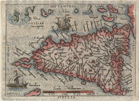
Ortelius/Marchetti, 1598 Siciliae Descriptio This great little miniature map shows rivers, lakes, and many towns on the island of Sicily. The stipple sea is adorned with a sailing ship, a galley, a sea monster, and an erupting volcano. Pietro Maria Marchetti produced the second pocket atlas based on Abraham Ortelius` folio "Theatrum". It is often referred to as the plagiarized version of the "Epitome". The copper plates are closely copied from those of Philip Galle`s 1593 Italian edition. On a full sheet of Italian text measuring 5.5 x 7.5". 4.1" W x 2.9" H Watermarked paper with marginal soiling and minor show-through of text on verso.

Lot 534
Ortelius/Marchetti, 1598 Malta Olim Melita Insula Charming miniature map of Malta with towns depicted with castles. The map is richly adorned with a sea monster, sailing ship, and the Apostle Paul`s shipwreck depicted off the northern coastline, with two swimming survivors and several onlookers on land. Pietro Maria Marchetti produced the second pocket atlas based on Abraham Ortelius` folio "Theatrum". It is often referred to as the plagiarized version of the "Epitome". The copper plates are closely copied from those of Philip Galle`s 1593 Italian edition. On a full sheet of Italian text measuring 5.5 x 7.5". 4.1" W x 2.9" H Watermarked paper with marginal soiling and minor show-through of text on verso.

Lot 536
Ortelius/Marchetti, 1598 Cyprus Insula This tiny map is a charming depiction of the island showing the rivers and cities. The island is surrounded by sailing ships and a sea monster. Pietro Maria Marchetti produced the second pocket atlas based on Abraham Ortelius` folio "Theatrum". It is often referred to as the plagiarized version of the "Epitome". The copper plates are closely copied from those of Philip Galle`s 1593 Italian edition. On a full sheet of Italian text measuring 5.5 x 7.5". 4.1" W x 3" H Watermarked paper with marginal soiling and minor show-through of text on verso.

Lot 539
Ortelius/Marchetti, 1598 Candia Olim Creta Beautifully and fully engraved copper plate map features exceptional detail of the island. The map has numerous place names and is embellished with a full stipple sea that has two sailing ships and a vigorous sea monster. Shows the mythological Labyrinth where the Minotaur was confined. Pietro Maria Marchetti produced the second pocket atlas based on Abraham Ortelius` folio "Theatrum". It is often referred to as the plagiarized version of the "Epitome". The copper plates are closely copied from those of Philip Galle`s 1593 Italian edition. On a full sheet of Italian text measuring 5.5 x 7.5". 4.1" W x 2.9" H Watermarked paper with marginal soiling and minor show-through of text on verso.

Lot 541
Ortelius/Marchetti, 1598 Sardinia This charming miniature map delineates all of Sardinia and part of Corsica. North is oriented to the left. The stipple engraved sea is embellished with a sailing ship and sea monster. Pietro Maria Marchetti produced the second pocket atlas based on Abraham Ortelius` folio "Theatrum". It is often referred to as the plagiarized version of the "Epitome". The copper plates are closely copied from those of Philip Galle`s 1593 Italian edition. On a full sheet of Italian text measuring 5.5 x 7.5". 4.1" W x 2.9" H Watermarked paper with marginal soiling and minor show-through of text on verso.
![Ortelius, Abraham 1598 Natoliae, quae olim Asia Minor, Nova Descriptio [on sheet with] Aegypti Recentior Descriptio [and] Car](http://lot-images.atgmedia.com/SR/36385/2893812/543-2013117142530_468x382.jpg)
Lot 543
Ortelius, Abraham 1598 Natoliae, quae olim Asia Minor, Nova Descriptio [on sheet with] Aegypti Recentior Descriptio [and] Carthaginis Celeberrimi Sinus Typus Three maps are on one folio sheet. On the left is a map of Turkey oriented with east at the top. The detailed map is based on the cartography of Gastaldi/Forlani and extends to include Candia and Cyprus. At top right is a map of northern Egypt showing the Nile River delta. Below is a map of the vicinity of ancient Carthage (Tunis) with many oared ships in the sea. French text on verso and marked page 113. 19.5" W x 12.7" H Watermarked paper with wide, original margins, all edges gilt, and a few small spots of foxing.
![Moxon, Joseph 1715 The Holy Bible, Containing the Old and New Testaments... [bound with] The Book of Common Prayer [and 6 Bib](http://lot-images.atgmedia.com/SR/36385/2893812/567-2013117142618_468x382.jpg)
Lot 567
Moxon, Joseph 1715 The Holy Bible, Containing the Old and New Testaments... [bound with] The Book of Common Prayer [and 6 Biblical maps] "This magnificent folio-sized King James Bible is bound with “The Book of Common Prayer”, “The Books Called Apocrypha”, “The New Testament”, and “The Whole Book of Psalms: Collected into English Metre” by Thomas Sternhold and John Hopkins. This edition of the King James Bible includes marginal notes from the Geneva Bible, an ironic combination because the Geneva Notes apparently played a role in King James` decision to commission a new Bible. In addition, this Bible features a series of 6 Biblical maps originally by Nicholas Visscher and translated from Dutch by Joseph Moxon: A. “A Map of All the Earth and How After the Flood it Was Divided Among the Sons of Noah”. The map illustrates how the world was divided up among the sons of Noah after the Flood. It is centered on the Old World and only the place names are concentrated there. The rest of the world is shown only with continental outlines, rivers and lakes. The “island of California” appears across the expansive Pacific Ocean where there are partial outlines for Japan, Australia and New Zealand. A series of vignettes surround the map illustrating the Creation and the Garden of Eden at top, with scenes from the Fall of Man to the Crucifixion of Christ at bottom. Two cartouches further decorate the sheet, including a dedication to Gilbert Sheldon, Archbishop of Canterbury. This is the second state, with the addition of Pennsylvania marked on the map. Reference: Shirley #457; Laor #516A. B. “Paradise, or the Garden of Eden. With the Countries Circumjacent Inhabited by the Patriarchs”. An attractive and uncommon map of the Middle East, including Cyprus, a portion of the Persian Gulf and the north shore of the Red Sea filled with details of Old Testament locations, including Babel and Nineveh. There is a coat of arms at upper left and a cartouche at upper right showing the expulsion of Adam and Eve from Paradise by the Angel. Reference: Laor #517. C. “Israels Peregrination, or the Forty Years Travels of the Children of Israel out of Egypt through the Red Sea, and the Wilderness into Canaan, or the Land of Promise”. This lavishly decorated map of the Holy Land depicts the flight from Egypt and the wanderings of the Children of Israel. Includes a fine title cartouche, ships sailing in both the Mediterranean and Red Seas, numerous putti, several engravings of religious icons, Moses, Aaron, and a charming scene of Jonas and the whale. Reference: Laor #519. D. “Jerusalem”. This detailed bird`s-eye view was one of the most popular plans of Jerusalem during the seventeenth century. While it is imaginary, it provides great detail of the city walls and streets, with 36 principal sites numbered and keyed to a table in a scroll at left, which is held aloft by an eagle. Solomon`s Temple is at upper center and Herod`s Palace is located at the far left. The scenes in the foreground include the Crucifixion at left and Salomon`s anointment at right. Reference: Laor #1084A. E. “Canaan, or the Land of Promise. Possessed by the Children of Israel: and Travelled Through by our Saviour Jesus Christ; and His Apostles”. This fine map of present-day Israel is oriented with north to the right. There is a large, decorative title cartouche at bottom flanked by vignettes depicting the life of Christ. At top, putti hold banners with the key to the map and scale of miles. Tiny ships and the track of Apostle Paul are shown in the sea. At top center is a coat of arms with a dedication to Lord Bishop Humphrey. Reference: Laor #522A. F. “The Travels of St. Paul and Other the Apostles...” This map portrays the Eastern Mediterranean from Rome, through Asia Minor and the Holy Land, to Babylon. Territorial divisions reflect the political conditions of the first century A.D. The route of Apostle Paul is charted from Jerusalem to Rome. The decorative panels at top and bottom show the major events of Paul`s journey; each vignette being a composite of two or three episodes. The one at the left of the cartouche shows Paul`s conversion, his baptism by Ananias, and finally his daring escape from the city. Other scenes depict the young Paul before his conversion, healing the paralytic, his ship wreck at Malta, and his appearance before Nero. At bottom left is a coat of arms with a dedication to Seth, Lord Bishop of Salisbury. Reference: Laor #523A. This example also includes three pages of meticulous genealogical notes of the Joseph Maude and Thomas Holme families (from 1662-1863) written in delicate manuscript by a previous owner. 6 maps, 91pp, 719pp, 160pp, 248pp, 54pp. Original full diced paneled brown calf over beveled wooden boards, with a central, ornate blind-stamped lozenge to each board, and raised bands on spine. The original brass clasps and catches are no longer present." 10.6" W x 16.8" H Five of the six maps are in very good condition with faint, scattered foxing and minor offsetting. The sixth map (Canaan) is in good condition with some show-through of old manuscript ink on verso. The text is mostly very good with light scattered foxing and toning, with heavy toning on the first and last few pages. The binding is sound but the hinges are starting. The front cover is cracked vertically near the fore-edge and has been professionally repaired. The spine is cracking and is missing a 4x2" piece at bottom. There is a bookplate from a previous owner (Rosa Walter Meertief, born c. 1872) on front pastedown.

Lot 657
Mercator/Cloppenburgh, 1673 Africae Nova Tabula This fine chart details the entire continent of Africa with Madagascar and the Arabian Peninsula. It was published in the Cloppenburgh atlas and is taken from Hondius` folio map of the same title (Norwich Africa #34). Includes the hypothetical interior detail, which is typical of maps from this period. The Nile originates from two large lakes well south of the Equator. Decorated in the sea with numerous sailing ships and sea monsters. Strapwork style title cartouche. Engraved by Pieter van den Keere. 9.7" W x 7.3" H A nice impression on a moderately toned sheet with light offsetting.

Lot 675
Mercator/Cloppenburgh, 1632 Abissinorum, sive Pretiosi Ioannis Imperium The legendary kingdom of the Christian Prester John is the central focus of this small and densely engraved map of central Africa. It is a reduced edition of the folio Mercator map and is cartographically similar to Ortelius` map and is based on the travels of the Portuguese explorer, Francisco Alveres, who searched for the mythical kingdom in the year 1520. The kingdom itself is shown atop the "Amara Monti" in the region where Alveres encountered the Coptic Christian ruler David II. The Nile is shown with its source in the Ptolemaic twin lakes of "Zaire" and the unnamed" Zaflan", at the foot of the Mountains of the Moon ("Zet Montes"). The map includes fancy script lettering, a large strapwork title cartouche and a bold moiré patterned sea. French text on verso and page number 607 on recto. 9.9" W x 7.4" H Very light scattered foxing with a few tiny chips and tears in blank margins that have been archivally repaired.

Lot 701
Audubon, J. J. 1860 Smew or White Nun, Mergus Albellus "This original chromolithograph is Plate 414 from the double-elephant folio Bien edition of Audubon’s great work on American ornithology. Audubon traveled throughout the U.S. and recorded 435 life-size images of every native bird in the country, depicting them in natural poses in their native habitats. This handsome engraving depicts a male Smew in flight with a female in the water below, with cliffs filling the landscape behind them. Audubon procured a male specimen himself at Lake Barataria (outside of New Orleans) circa 1821 and made a drawing on the spot. Although Audubon recognized that the Smew was not an American species, he decided to include it in his “Birds of America” as the duck was known to make occasional (and potentially accidental) visits to the U.S. The full sheet measures 25.5 x 39.9”. Julius Bien was among the pioneers in developing chromolithography (an early form of color printing) in the United States. The Bien edition was initiated by John Woodhouse Audubon, the younger of the two Audubon sons. Originally conceived to be a full reissue of the 435 images in 44 parts consisting of ten images each, the project was discontinued in 1860 after only 15 parts had been issued. As a result, these plates are even rarer than the first “Birds of America” edition." 19.8" W x 25.8" H Vivid color with a few tiny, unobtrusive spots in image and very light marginal soiling. There are several expertly repaired tears all confined to the blank margins and far from image. Professionally backed in Japanese tissue.
![Speed/Kaerius, 1666-68 A Prospect of the Most Famous Parts of the World [bound with] England Wales Scotland and Ireland Descr](http://lot-images.atgmedia.com/SR/36385/2893812/728-2013117143148_468x382.jpg)
Lot 728
Speed/Kaerius, 1666-68 A Prospect of the Most Famous Parts of the World [bound with] England Wales Scotland and Ireland Described… "This handsome miniature atlas is famously known as the “miniature Speed” atlas since the maps, engraved by Pieter van den Keere, were based on John Speed`s folio-sized maps published under the same title, “A Prospect of the Most Famous Parts of the World”. This example is a dual atlas containing both the world atlas and an atlas of the British Isles. Both atlases had an interesting publication history, beginning with the atlas of the British Isles, which was first published between 1605 and 1610. In 1619, the British Isles maps came into the hands of London printer George Humble, who included additional maps and reprinted them under the name of John Speed, thereby initiating the popular series of “miniature Speed” atlases. The success of the miniature “Theatre” was then joined in 1646 by the first edition of the miniature “Prospect” atlas published by George Humble`s son, William Humble, and was sometimes bound separately from the British Isles atlas and sometimes bound in a dual atlas. The miniature maps in “A Prospect” were engraved by Van den Keere while in his 70`s, and are believed the be the last maps engraved by him before his death at the age of 75. The atlas is complete with 20 maps: the world, Asia, Africa, Europe, Americas, eleven maps of European countries, Persia, the Turkish Empire, China and Tartary. Each of the maps is single page with text on verso taken from Speed`s folio atlas, and all are signed with Van den Keere`s Latinized name, Petrus Kaerius. The simple, typographic title page contains the list of maps and is dated 1668 with the imprint of Roger Rea. The double-hemisphere world map, “A New and Accurat Map of the World,” depicts a huge southern landmass, labeled “Unknowne Land” in the eastern hemisphere and “Magallanica” in the western hemisphere. The northwest coast of North America shows a conjectural coastline that extends to the Strait of Anian. Although the world map shows a peninsular California, the western hemisphere map, “America”, depicts “California as an island” with a flat northern coast and several place names. The cartography of this map is based on Goos` folio map from 1626, and omits any French presence in Canada. “Newe Ing. Land” is located north of the St. Lawrence River, and “Plymuth” is the only European settlement depicted. There are 62 (of 63) maps in “England Wales Scotland and Ireland”, including the folding map of the British Isles, separate maps of England, Wales, Scotland and Ireland, and 57 county maps. (The map of Yorkshire is missing.) The majority of the British Isles maps were also engraved by Van den Keere and were based on Saxton for the English and Welsh county maps, on Ortelius for the Scottish maps, and on Van den Keere`s own map of Ireland for the Irish maps. It is believed that the maps of the British Isles and of England were not engraved by Van den Keere, but were commissioned by Humble for the 1627 edition. The British Isles map was based on Blaeu`s miniature edition of Camden`s Britannia, and the England map was based on Speed`s folio map, omitting the costumed figures. The text in this atlas was derived from Speed`s “Theatre of the Empire of Great Britain”. The title page is dated 1666 and features two putti, a Dane and a Norman. Full leather with raised bands on spine and the initials “WP” stamped on front and back covers. The provenance of this atlas is quite fascinating, as it comes from a direct descendent of the cartographer John Speed. The Speed family believes the atlas was purchased in the 1800`s and then passed down from generation to generation." 6.6" W x 4.3" H All the maps except for two are in very good condition, with light overall toning and an occasional spot of foxing. The title page of the British atlas and the British Isles folding map are in good to satisfactory condition with heavier toning, soiling, and several fold separations and small chips. The map of Radnor has a hole apparently caused by a paper flaw, and several county maps have short tears primarily confined to blank margins, all of which have been archivally repaired. The last few pages of the text block are heavily toned around the edges caused by contact with the leather, which does not affect any maps. The covers and spine are heavily worn but have been recently conserved, with numerous small chips and cracks to the leather repaired.

Lot 729
Moll, Herman 1723 The Compleat Geographer: or, the Chorography and Topography of All the Known Parts of the Earth. To Which Is Premis`d an Introduction to Geography ... The Fourth Edition... "This is the fourth edition of Moll`s “Compleat Geographer” and contains a total of 42 maps interspersed within the text, most with attractive outline color (all but the Americas). There are two volumes within the atlas: volume one (402 pp.) is focused on Europe and contains 20 maps including a world map featuring the “island of California”, Europe, Britain, Italy and Russia to name a few. The second volume (288 pp.) includes 9 maps of Asia, 4 of Africa, 4 of North America and 5 of South America. Of particular importance is “The Isle of California. New Mexico. Louisiane. The River Misisipi. And the Lakes`s of Canada” which prominently features the “island of California” and the western part of North America and combines a vast amount of information and quite a bit of misinformation. Just north of California are “The North Straits” that separate the island from “Agubela de Cato” and the “Land of Panimaha”. Further north lies the “Straits of Annian” and the partial coastline of” Annian”. Four major rivers flow west into the Gulf of California with “The 7 Cittys” near the mouth of the “Coral R.”, just west of Acoma. “Conibas Lake” forms the source of the “North or Bravo R.” (Rio Grande), which correctly empties into the Gulf of Mexico. Much of the map appears to have been derived from Hennepin, but it contains vastly more detail and the locations of numerous Indian villages, including the “Missourits” on the bank of what would become the Missouri River. In Canada, the “Mission des Recolets” is located just south of the “Lake of Assinibouels”, and is noted as “ye Farthermost in ye whole Country”. The other maps related to North America include “The English Empire in America...” which covers the entire eastern seaboard from Florida north to Newfoundland; “Mexico, or New Spain. Divided into the Audiance of Guadalayara, Mexico, and Guatimala, Florida”, and “America “which depicts the entire Western Hemisphere. Contents include frontis, title page, advertisement, table of contents, index, introduction (51 pp.) and main text (690 pp.). Folio, hardbound in original leather with raised bands on spine." 9.5" W x 14.2" H The maps range from good to near fine with some offsetting and light text show-through in the image on some. There is a damp stain at the top and bottom of the gutter throughout that does not impact any of the map images. Covers are very worn and detached and the spine has perished, resulting in the text block being separated into two sections. Given the complete map count, this atlas would benefit from professional rebinding.

Lot 734
Stieler, Adolph 1876 Hand Atlas Uber Alle Theile der Erde und Uber das Weltgebaude "This handsome and complete atlas contains 89 steel engraved maps in a beautiful combination of hand coloring and printed color with precise engraved lines characteristic of Stieler`s fine work. The large double-page maps are numbered 2 to 90, and the beautifully engraved title page is number 1 according to the contents page. Each map is a study in precision engraving, with exceptional detail. Of the maps, four are celestial (including a fabulous engraving of the moon), two are thematic, and the rest cover the continents, polar regions and countries of the world. Many of the maps include insets of principal cities and topographical features. The map of Antarctica gives terrific detail of the latest discoveries. The Atlantic Ocean map details the sub-sea telegraph cables. The atlas has six maps of United States interest. The map of the United States and Mexico shows the newly established state of Colorado along with numerous territories, including Washington, Idaho, Montana, Dacota, Arizona, New Mexico and Indian Territory (Oklahoma). The map also depicts roads and a prominently featured northern transcontinental railroad from New York City to San Francisco. The maps are dated 1876. Folio. Original hard covers in blue cloth and quarter leather spine and tips with gilt titles on front and spine. Published by Justus Perthes." 10.3" W x 15.6" H The maps range in condition from near fine to good, with the majority being in "A" and "B+" condition. Some of the maps have foxing, ranging from very light to moderate, and a couple of maps have short centerfold separations. The last five maps have a faint damp stain along fore-edge confined to blank margins. The binding is excellent and the covers and spine show light wear.

Lot 737
Tunison, H. C. 1891 Tunison`s Peerless Universal Atlas of the World "This is a lovely and unusual atlas with approximately 80 wax engraved, hand colored maps and diagrams, most with decorative borders and some with vignettes. Thirty-seven maps relate to the United States. The map of “California, Oregon & Nevada” is particularly nice with insets of Yosemite and the Redwoods. Also featured are two pages of presidential portraits, two pages showing agricultural production, and numerous engravings showing the diverse civilizations and cultures of the world. The last map is “Map of the Regions about the Unknown North Polar Sea Showing the Latest Exploring Expeditions”. The maps in this atlas are uncommon for their late hand coloring, a laborious process that was largely abandoned two decades earlier. Please note that this example is missing pp. 79-80 which are maps of Louisiana/Mississippi and Florida, as well as the title page. Small Folio, 207 pp. Hardbound in original, embossed maroon cloth boards with gilt title and illustration on the front cover." 12.3" W x 14.3" H Maps are generally good to very good with some pleasant light toning, occasional soiling, and a few pencil notations mostly in the blank margins. The map of Georgia & South Carolina has been trimmed in the left blank margin and has nearly separated. Covers and spine show light wear with a chip at the bottom of the spine. The front hinge is starting and the back hinge is nearly perished.

Lot 738
Cram, George F. & Company 1893 Cram`s Unrivaled Atlas of the World Indexed This is a complete and very nice late 19th century atlas with 135 single-page, and 26 double-page maps covering all the U.S. states and major cities, Canadian provinces and countries throughout the world. The maps are printed on both sides of the sheet, and all double-page maps are printed on one sheet that is attached to the atlas with a backstrap. There are numerous diagrams, historical charts and city plans. The historical section on the United States includes additional thematic maps. This edition includes a double-page map of Jackson Park in Chicago, the site of the World`s Fair in this publication year, along with six pages of illustrations featuring the buildings at the fair. Also included is a map of "Yellowstone National Park Wyoming" showing mainly topography. 370 pages. Complete. Folio. Hardbound in original brown cloth with embossed title on front. 11.8" W x 15" H Condition code is for the maps which are clean and bright with just the occasional small spot or minor damp stain. Endpapers are missing and the title page has a 3" tear at top and a long extraneous crease. The coves are loose, bumped and worn, and partially detached.

Lot 751
1967 The English Pilot the Fourth Book Facsimile atlas of "The English Pilot The Fourth Book" from the Theatrum Orbis Terrarum series published in 1967. 148 pages, with bibliographical note by Coolie Verner, and featuring 15 double-page, and 5 full-page charts of American waters. Elephant folio, hard boards bound in cloth with dust jacket. 12.2" W x 20" H Some soiling on covers and dust jacket.

Lot 45
Henri-Louis DUHAMEL DU MONCEAU (1700-1782) physicien, botaniste et agronome. Traité des arbres et arbustes qui se cultivent en France en pleine terre (Paris, H.-L. Guérin et L.-F. Delatour, 1755), tome II seul, avec ADDITIONS et CORRECTIONS autographes ; in-4 avec planches gravées, couverture cartonnée usagée., EXEMPLAIRE DE TRAVAIL ABONDAMMENT ANNOTE, CORRIGE ET COMPLETE DE CET IMPORTANT TRAITE D`ARBORICULTURE, truffé de plus de 90 feuillets de notes ou additions, dont plusieurs avec DESSINS ; ces feuillets sont pour la plupart intercalés ou collés à l`endroit des sujets traités, d`autres glissés en tête ou à la fin du livre. On a aussi porté de nombreuses additions, notes et corrections sur une centaine de pages de texte ou au dos des planches., Tome II seul de ce traité en deux tomes, incomplet des feuillets de faux-titre et titre et des 3 dernières pages de la table des matières, mais bien complet des 114 planches (dont 3 dépliantes) gravées sur bois, utilisant les bois gravés au XVIe siècle pour l`herbier de Mattioli., La plupart des additions sont de la main de Duhamel du Monceau, d`autres de la main d`un collaborateur, probablement son frère Alexandre DUHAMEL DE DENAINVILLIERS (1697-1775), à qui est adressée une lettre M. de Bregançon sur le bois de mûrier (1758), et qui dresse une liste d`échantillons à demander à MALESHERBES, ainsi qu`une longue description détaillée de pins (avec dessins)., En tête, Duhamel du Monceau a collé une note avec croquis sur le treuil utilisé par M. de Corbeille pour relever les arbres fruitiers abattus par le vent. Le Traité s`ouvre par une description du magnolia ; on a intercalé deux beaux dessins à la mine de plomb et un double feuillet de notes d`après le botaniste écossais Philip Miller : “ Miller décrit quatre especes de Magnolia. 1. Magn. Lauri folio subtus albicante Catesby. (Je crois que c`est là le Bleu). 2. Magn. Absissima, flore ingenti candido Catesby. - Ces deux sont dans le Tr. des Arbr. et Arb. […] Le n° 4 est rare en Angleterre, et dans l`Amérique même. On en trouve au Nord de la rivière de Susquehannah : je n`ai pas pu découvrir ce nom dans la carte de la Caroline “. L`article “ Magnolia “ est aussi annoté sur le livre même : “ M. de Fontenette qui a esté longtems medecin a la Louisiane m`a dit que le bois du Laurier tulipier estait fort dur et bon a bruler mais qu`il pourit promptement quand on l`expose a l`humidité “, etc. L`article suivant, consacré au pommier, porte en marge de la liste de 12 espèces : “ Les fleurs du pommier n° 4 [pommier de Virginie à fleurs odorantes] pendent à de longues queues elles ressemblent beaucoup à celles du bigarreautier. Elles sont d`un rouge tendre fort agréable et repandent une odeur très gracieuse. Le fruit n`a aucun merite. Il y a chez M. le chevalier de Janssen un pommier reçu de Virginie qui ne quitte point ses feuilles et dont les fleurs sont odorantes “… Etc. Les notes se réfèrent très souvent aux travaux de Miller, de Linné, de Tournefort, de Clayton…, On notera en particulier des feuillets ajoutés concernant le Menispermum, le Mespilus (nefflier, avec croquis), le Molle, le Morus (mûrier), le Nux (noyer), le Paliurus, le Pin, le Platane, le Populus (peuplier), le “ Pseudo-Acacia “, le Ptelea (avec dessin), le Pyrus (poirier, avec dessin), le Quercus (chêne, avec feuilles de chêne collées), les Rhamnoïdes, le Rhis (vinaigrier), le Rosier, la Sabina, le Salix (saule, plus un imprimé joint), la Siliqua (caroubier), le Smilax, le Sorbus (sorbier), la Spiræa (notes et dessins sur la Spirea de Tartarie), le Taxus, le Terbinthus, le Tilleul, le Toxicodendron, le Viburnum (viorne), l`Uva-ursi (busserolle), le Yucca… À la fin du livre, des notes concernent le Nyssa et le Psoralea (avec dessin) : “ Le psoralea est un joli arbrisseau. Ses feuilles sont formées de trois foliolles portées par une queue assez longue deux sont attachées à cette queue sans en avoir qui lui soyent propre celle du milieu en a une qui lui apartient. Les feuilles sont posées alternativement sur les branches “… etc.
Lot 20
DOUGLAS Sir Robert, The Peerage of Scotland containing historical and genealogical account, 2nd edit, revised and corrected by John Philip Wood, pub Edinburgh 1813, red leather with gilt titles and tooling and The Baronage of Scotland, illus with coat of arms, pub Edinburgh 1798, red leather, folio (3)
Lot 164
WHITE Gilbert, Museum Edition of The Natural History of Selborne, preface by Lord Selborne and David Attenborough, bound by Zaehnsdorf`s of London, 85/150, in slip case, a Folio Society Copy 3rd impression 1965 in slip case, a Ray Society edition No 160, pub 1993 a New edition, pub century Hutchinson 1988 (4)
Lot 255
Sitwell S., Buchanan H. and Fisher J. . Fine Bird Books 1700-1900. Folio. Pp.104, 16 col. plates, 1 folding, 24 collotype plates, Ltd. 2000 copies. Original cloth marbled boards: Dustjacket incomplete. and Mitchell, F.S The Birds Of Lancashire. London: John van Voorst. 1885.First edition. 2 coloured lithographs. 13 other illustrations, folding map and vignettes. green cloth, gilt titles. (2)
Lot 276
ANON, A Jolly Children`s Book Merry Moments Full Of Fire Side, London: McCorquodale - Bigger Value Books no date Pp, 38, Folio, Stiff boards.Many illustrations. Some colouring. Browning Robert illustrated by Kate Greenaway The Pied Piper of Hamelin, London: Routledge 1888. Large 4to, Pp.64. Bound in original illustrated boards with cloth spine, some shelfware to outer edges. Browning Robert illustrated by Kate Greenaway The Pied Piper of Hamelin London: Frederick Warne. Square 8vo. Pictorial boards. Chromolithographs by Kate Greenaway. pub. Edmund Evans, Ltd. Thompson 19. Stevenson, Robert Louis. Charles Robinson. A Child`s Garden of Verses. pub. London: Bodley Head. 1928. [16875] Pp. xii, 153, [11] adverts. Black and white illustrations and 8 coloured illustrations. Cream boards with an illustration. Inscription dated 1928. (4)


-
86082 item(s)/page