36562 Preisdatenbank Los(e) gefunden, die Ihrer Suche entsprechen
36562 Lose gefunden, die zu Ihrer Suche passen. Abonnieren Sie die Preisdatenbank, um sofortigen Zugriff auf alle Dienstleistungen der Preisdatenbank zu haben.
Preisdatenbank abonnieren- Liste
- Galerie
-
36562 Los(e)/Seite

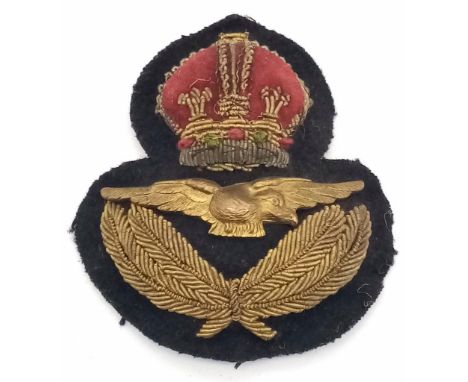
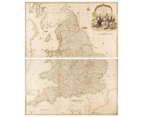
Los 88
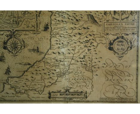
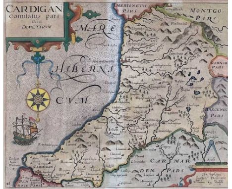
Cardiganshire. Speed (John), Cardigan Shyre Described with the due forme of the Shire Town as it was Surveyed by J. S. Anno 1610, John Sudbury & George Humble, circa 1611, uncoloured engraved map, inset town plan of Cardigan, large strapwork cartouche, mileage scale and compass rose. Framed and glazed. H.51 W.63cm.
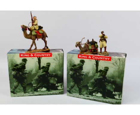
Los 284
King and Country - Two boxed figures from King and Country including AK33 Vichy French Camel Corp Arab on Guard; together with AK34 Vichy French Camel Corps Officer with Compass. Figures appear to be in Mint condition in Excellent boxes with some minor storage wear. (This does not constitute a guarantee) (K)
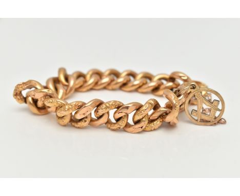
Los 9
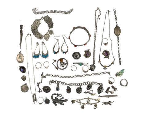
A YELLOW METAL CURB LINK BRACELET, hollow links alternating between floral patterned and plain polished links, fitted with an integrated box clasp AF, also attached is a Masonic square and compass charm set with rose cut diamonds, fitted with a jump ring for suspension, approximate diameter 14.8mm, with an additional safety chain, all unmarked, length 190mm, approximate gross weight 17.2 grams (condition report: clasp is broken and requires attention, most links have damage and dinks, soft solder repair to one link, overall condition fair, acid test result for 18-22ct)
Los 108
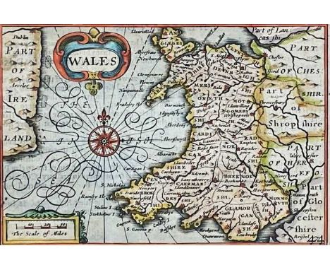
PIETER VAN DEN KEERE coloured antiquarian map entitled in cartouche 'Wales', showing the whole of Wales and a small section of Ireland, with inset scale of miles, compass and other illustrations, circa 1620s, 8 x 12cmsProvenance: the Welsh art collection of award-winning television producer, the late Pat Llewellyn (1962-2017), by descentComments: framed and glazed, ready to hang

Los 20
America.- Merian (Matthaeus) Virginia. Erforshet und Beschriben durch Capitain Iohan Schmidt, early map based on the sixth state of John Smith's prototype map showing explorations and observations made by Smith and the Jamestown settlers, with small crosses marking the range of those explorations, decorated with large compass rose set within the Atlantic sea in the lower left with numerous rhumb lines, decorated with a vignette of the Powhatan's Council, and a Susquehannock Indian in the upper right quadrant, engraving, on laid paper without watermark, platemark 293 x 367 mm (11 1/2 x 14 1/2 in), sheet 327 x 414 mm (12 7/8 x 16 1/4 in), central vertical fold, printers' crease along the central fold to lower half, minor surface dirt and browning, mainly marginal, unframed, [circa 1647]

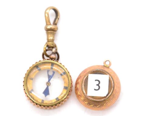
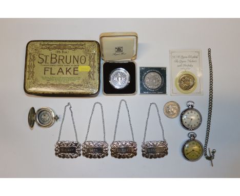
Los 1013
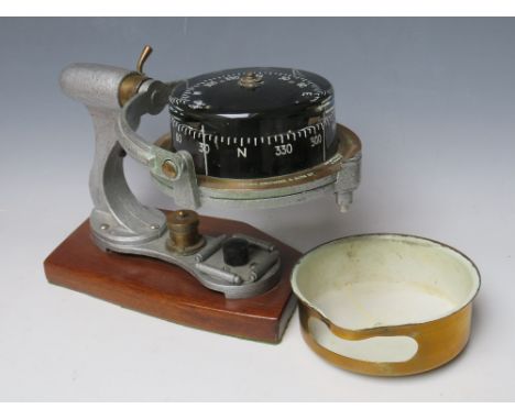
A gold circular cased keyless wind open-faced lady’s fob watch, the gilt movement detailed ‘AM.Watch Co. Waltham Mas 9394704’, the inner and outer cases detailed ‘10c’, total weight 43.9g, case diameter 3.8cm, together with a silver cased keyless wind open-faced fob watch, import mark Glasgow 1910, case diameter 3.3cm, two further keyless wind open-faced pocket watches, an Omega gilt metal fronted and steel backed lady’s wristwatch, two gentlemen’s wristwatches, comprising Citizen Quartz Crystron and Renel, and a brass cased compass (glass damaged).
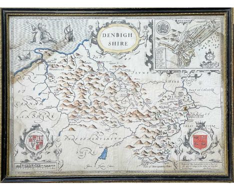
Los 421
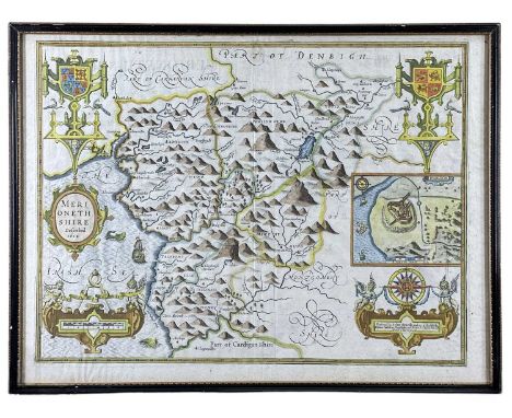
SPEED, John. 'Denbighshire' Engraved map, inset town plan of Montgomery, large strapwork cartouche, compass rose and mileage scale, English text to verso, centre fold, toning, partially hand coloured, framed and double glazed, 49 cm x 58.5cm, [17th century]; With one other and a framed Robert Morden of Cheshire. (3)
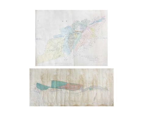
Los 164
'Trenwith Mine, St Ives,' Surveys and maps by Leonard Hawkey, 1911. Hand drawn cross sectional survey on thin linen by L. Hawkey, scale 1 inch to 5 fathoms, showing Victory Shaft, Berriman Shaft and Old Sump Shaft, reference of Adit Level, damp staining to edges, colour ink offsetting, rolled, approx 75cm x 215cm, 1911; 'Longitude Section', scale 1 inch to 5 fathoms, damp staining and nibbles to edge, rolled, approx, 75cm x 220cm [L. Hawkey, 1911]; Handrawn map on linen, with scale and compass, showing mine burrows, Stennack Road and Trenwith Terrace, damp staining, rolled, approx, 65.5cm x 143cm, [L. Hawkey, 1911], '....Berriman Shaft, Transverse Section,' hand drawn, scale 1 inch = 30 feet or 5 fathoms, damp staining to edges, approx 56cm x 21cm on much larger thin linen, rolled, [L. Hawkey, 1911]; With the same for 'Old Sump Shaft' and 'Victory Shaft'; Hand drawn survey both transverse and longitudinal sections for 'East Virgin Shaft and Sump Shaft', on linen with damp staining to edge, rolled, approx 68cm x 100cm, [L. Hawkey, 1911]; 'St Ives. Ordnance Map to show Leases and accompany Report of October 8th 1907,' tears and nibble to edges, rolled, approx 88cm x 109cm. (8)Surveyed by Hawkey during the reopening of the mine, by the German-owned 'British Radium Company' for the extraction of uranium (and radium). A fascinating survivor of subterranean St. Ives. From the estate of Ron Hooper, M.V.O., A.C.S.M., F.I.M.M.Born in St.Agnes, he graduated from Camborne School of Mines. After a short career mining in the Gold Coast of Ghana he joined the Camborne School of Mines, eventually becoming Senior Lecturer in Surveying. At the same time, he acted as an independent mining engineer and was appointed mineral agent for several Cornish estates including the Duchy of Cornwall, Tregothnan, and the Godolphin Estate (amongst others).


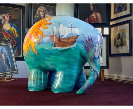
Los 100
An Elmer Elephant, 'Compass Rosie' painted by Anne-Marie Byrne, height approx 110cm. Anne-Marie is a Suffolk-based artist, an ex-archaeologist and civil servant. Anne-Marie rediscovered her artistic roots when Pigs Gone Wild trail came to Ipswich in 2016. She has participated in several trails around the UK, painting lions, sun bears, hares, giraffes, bees, ducks and otters. She also painted a Van Gogh inspired car that went all the way to Monte Carlo in a charity rally. When not painting, Anne-Marie creates digital art and writes fiction.

Los 376
Simmons, Mary Ann (British, 1959-present); b. Vancouver, emigrated to United Kingdom 1988 ENGLAND, The Fourth Service 1939-1945, 2002, a cast bronze medal by Mary Ann Simmons [Crucible Foundry] for the British Art Medal Society, concentric radiating waves, rev. map of the Western Atlantic approaches and the Rockall Trough, site of the first vessel to be sunk by a U-boat on the first day of World War II, edge highlight-impressed the fourth service 1939-1945 between the points of the compass, highlight notches on upper reverse edge, 90mm, 545.65g (The Medal 41, pp.118-19). Extremely fine, as made, a poignant medal, very rare; in black pouch of issue £100-£150 --- Provenance: bt BAMS, April 2003 Edition of 10. The medal commemorates the role of the Merchant Navy as the ‘fourth service’ during World War II. The reverse alludes to the sinking of the passenger liner Athenia, outbound from Liverpool to Montreal, torpedoed by U-30 220 miles north-west of Ireland at 7.30pm on 3 September 1939, the day that Britain declared war with Germany, with the loss of 117 lives. For a full description of the background to the issue of the medal and for an explanation of the notches on the upper part of the reverse, see The Medal 41, p.118.

Los 111
Deschamps, Léon-Julien (French, 1860-1928); b. Paris FRANCE, L’Étude, 1908, an Art Nouveau bronze award plaque by L.-J. Deschamps, naked female standing amongst classical ruins, holding a parchment and a compass, rev. open book resting on palm branch, named (Cinquantenaire de la Librairie Armand Colin, 1870-1920), edge impressed bronze and cornucopia, 81 x 46mm, 112.67g (PBE 364; CGMP p.143; cf. DNW M14, 1363). Extremely fine £80-£100 --- Provenance: bt Simmons, July 2002 Armand Colin, of 18 rue de l'Abbé de l'Épée, Paris, was a publishing house founded in 1870 by Auguste Armand Colin (1842-1900), and is now part of Hachette.
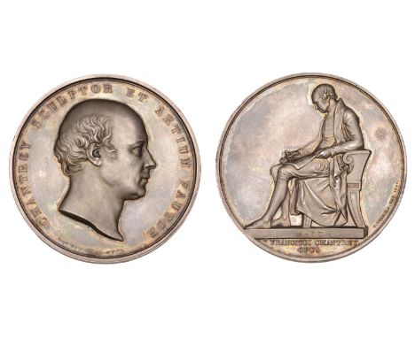
Los 441
Wyon, William (British, 1795-1851); b. Birmingham ENGLAND, Sir Francis Chantrey, 1846, a silver medal by W. Wyon for the Art Union of London, bust right, rev. James Watt seated left, a drawing of a plan resting on his lap, on which he rests a compass held in his right hand, from Chantrey’s sculptured memorial in Handsworth Church, Birmingham, edge impressed art-union of london 1843, 55mm, 75.35g (Beaulah 1; BHM 2227; BDM VIII, 683; E 1381). Extremely fine and richly toned, very rare; perhaps only 30 struck and awarded as prizes by the Union in 1847 £300-£400 --- Sir Francis Legatt Chantrey (1781-1841) was the leading portrait sculptor in Regency Britain. Intended as the first medal in the Art Union of London series and sanctioned in 1843, it was not until late in 1846 that Wyon, until then heavily involved in producing Indian campaign medals, was able to finalise a working set of dies. Medals were struck in two batches, in 1846 and 1847.

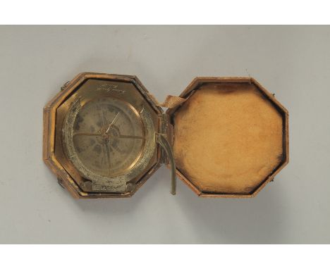
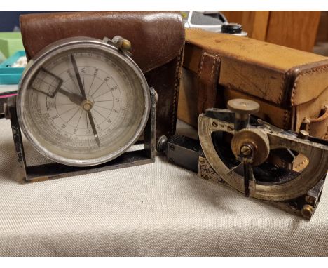
Los 257
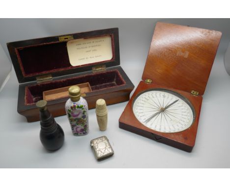
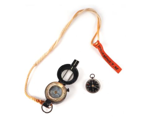
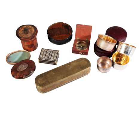
A DUTCH BRASS TOBACCO BOX17th/early 18th century, with engraved decoration, 17.5cm long; a tortoiseshell magnifying glass, 18th century, 8cm; a collapsible silver-plated beaker in a red morocco case, 19th century, 7.5cm diameter; a George III pocket compass in a mahogany case, 5.5cm wide; and three other boxes (7)
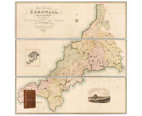
Los 37
Cornwall. Greenwood (C. & J.), Map of the County of Cornwall from an Actual Survey, made in the Years 1826 & 1827, by C. & J. Greenwood. Most Respectfully Dedicated to the Nobility, Clergy & Gentry of the County, published Greenwood & Co. 1827, large scale engraved map on three sheets, sectionalised and laid on linen, bright contemporary wash colouring, inset map of the Scilly Isles, calligraphic cartouche, engraved vignette of St. Michaels Mount, table of explanation and compass rose, faint offsetting, each sheet approximately 605 x 1845 mm, each sheet edged in green silk, marbled endpapers, contained in a contemporary tree calf book box with a contrasting red morocco gilt label to the spineQTY: (1)NOTE:R. C. E. Quixley (2nd edition expanded by J. M. E. Quixley). Antique Maps of Cornwall and the Isles of Scilly, number 76. A fine copy in very good condition.
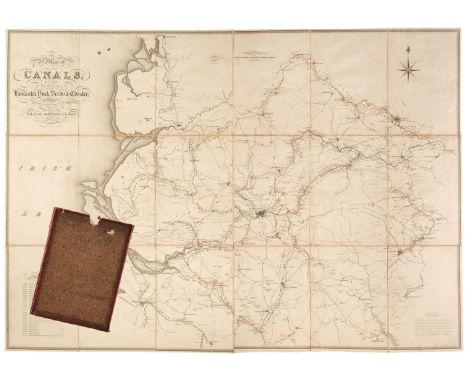
Los 77
Johnson (William and Son). A Map of Several Canals situated in the Counties of Lancaster, Derby, York & Chester; Shewing the Heights of their pools above the Level of the Sea at Low Water...., 1825, map with contemporary outline colouring, engraved by J. & G. J. Pickett, sectionalised and laid on linen, calligraphic title, compass rose, mileage scale and table of reference, slight ink staining, 865 x 1240 mm, marbled endpapers, contained in a contemporary marbled card slipcase, case worn and rubbedQTY: (1)
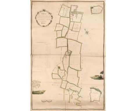
Los 53
Estate Plan. Sparrow (Joseph), A Map of an Estate belonging to Mr. J. Dunk, also Stock Farm situated in the Parishes of Smeeth, Brabourn & Aldington in the County of Kent, 1803, pen, ink and watercolour plan on vellum, floriate cartouche, compass rose, contents list and scale of rods and chains, two inset maps of adjacent fields, two watercolour vignettes, one of a pastoral scene with cattle and sheep, the other of a running hare, old folds, some dust soiling, faint later pencil annotations, 910 x 630 mmQTY: (1)
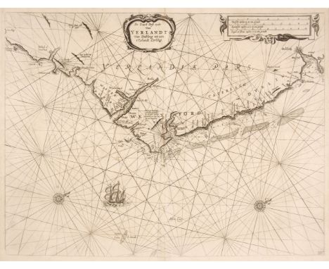
Los 70
Ireland. Lootsman (Jacob), De Zuyd Oost Zyde van Yerlandt van Dubling tot aen t'Eylandt Corkbeg, circa 1668, uncoloured engraved chart of the southeast coast of Ireland from Dublin to Cork, ornamental strapwork title and distance scale, numerous rhumb lines, compass rose and ships, one closed tear professionally repaired at the base of the central fold, 415 x 545 mmQTY: (1)
Los 109
Sea Chart. Van Keulen (Johannes), Nieuwe Paskaart van Ierland en de West Kust van Engeland ..., The New Sea Map of Ireland and the West Coast of England, containing St. George and the Channel of Bristol..., Amsterdam, circa 1735, large hand-coloured engraved sea chart of the west coast of England & Wales, The Irish Sea and Ireland, on two conjoined sheets, oval cartouche, compass rose and numerous rhumb lines, old folds, slight creasing, 600 x 960 mmQTY: (1)NOTE:Originally published in the Zee-Faakel.
![The Caribbean. Mount (Richard & Page Thomas), A Correct Chart of the Caribbee Islands [1715 - 50], hand-coloured engraved](https://cdn.globalauctionplatform.com/910db78b-cd1e-4760-a5d0-b0dc011def41/ad64e0e7-4cd8-4c96-b6af-b11e011e4d81/468x382.jpg)
Los 118
The Caribbean. Mount (Richard & Page Thomas), A Correct Chart of the Caribbee Islands [1715 - 50], hand-coloured engraved map, orientated to the east, large strapwork cartouche, compass rose and numerous rhumb lines, 435 x 545 mmQTY: (1)NOTE:A chart of the Lesser Antilles extending from Puerto Rico to Venezuela. The chart was published in Mount & Page's The English Pilot. The Fourth Book Describing The West India Navigation, the first sea atlas of America containing charts only from English sources.
Los 120
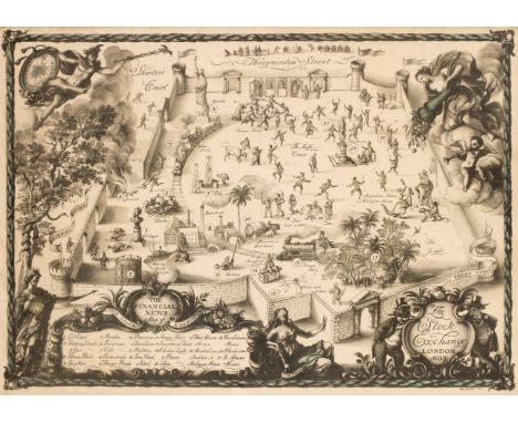
* The Stock Exchange. Whistler (Reginald John, 'Rex'), The Stock Exchange London 1933, London: The Financial News, 1933, colour photolithograph, additional cartouche with the title 'The Financial News map of the Stock Exchange' with a table of explanation below, numerous allegorical symbols and figures surrounding the map, slight marginal staining, laid on later card, 390 x 535 mm, framed and glazedQTY: (1)NOTE:A scarce map crammed with allegorical symbolism. The cartouche is supported by a bear and a bull, the classic representations of a sellers and buyers market, and both are shown in morning dress. The secondary cartouche is flanked by King Midas who has coins spilling from his waist and Dame Fortune who is blindfolded and holding a pair of scissors and whose arm rests on the 'rota fortunae' or wheel of fortune, a symbol of the capricious nature of fate. In the upper corners of the map are representations of Mercury carrying an elaborate compass and the goddess Demeter spilling her cornucopia into the market. The stock exchange itself is shown as a castellated courtyard within whose walls commodities, gilts and bonds are depicted being traded by a variety of humorous vignettes.
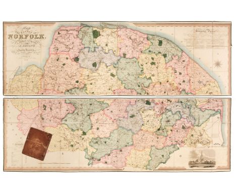
Los 101
Norfolk. Bryant (Andrew), Map of the County of Norfolk from Actual Survey by A. Bryant in the Years 1824, 1825 and 1826, Respectfully dedicated to the Nobility, Clergy & Gentry of the County, published A. Bryant, Dec. 1st. 1826, large-scale engraved folding map on two sheets, bright contemporary hand colouring, sectionalised and laid on linen, calligraphic cartouche, list of the ecclesiastical divisions, compass rose, table of explanation and uncoloured engraved vignette of Norwich Cathedral, slight offsetting, bordered with green silk, each sheet approximately 750 x 2275 mm, contained in a contemporary sheep book box, box heavily worn and frayed with one section near detachedQTY: (1)NOTE:T. Chubb. A Descriptive List of the Printed Maps of Norfolk 1574 - 1916, page 106.
![* Worcestershire. Speed (John), Worcestershire Described, Thomas Bassett & Richard Chiswell [1676], hand-coloured engrave](https://cdn.globalauctionplatform.com/910db78b-cd1e-4760-a5d0-b0dc011def41/9b7dde53-73ef-4935-8aa4-b11e011e63ec/468x382.jpg)
Los 133
* Worcestershire. Speed (John), Worcestershire Described, Thomas Bassett & Richard Chiswell [1676], hand-coloured engraved map, inset city plan of Worcester, large strapwork cartouche and compass rose, small areas of strengthening to the verso, 385 x 505 mm, mounted, framed and double-glazed, English text on verso, together with Morden (Robert). Worcestershire [1695 or later], hand-coloured engraved map, 365 x 425 mm, mounted, framed and glazedQTY: (2)
Los 40
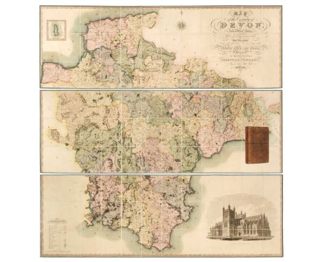
Devon. Greenwood (C. & J.), Map of the County of Devon from an Actual Survey, made in the Years 1825 & 1826 by C. & J. Greenwood, most Respectfully dedicated to the Nobility, Clergy and Gentry of the County, by the Proprietors Greenwood, Pringle and Co., February 20th, 1827, large scale engraved map on three sheets, sectionalised and laid on linen with bright contemporary wash colouring, inset map of Lundy Island, calligraphic cartouche, compass rose, table of explanation, uncoloured engraved vignette of the 'North West View of Exeter Cathedral', slight offsetting and spotting, each sheet edged in green silk, each sheet approximately 645 x 1905 mm, contained in a contemporary tree calf book box with a contrasting red morocco gilt label to spineQTY: (1)NOTE:Batten & Bennett. The Printed Maps of Devon, number 96.
Los 106
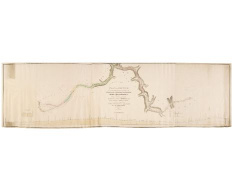
Railways. Stephenson (George, surveyor), Plan and section of an Intended Railway, commencing at the Liverpool and Manchester Railway in Salford in the Parish of Manchester and County Palatine of Lancaster, and Terminating at or near to Quarry Gap, in the West Riding of the County of York, where it is intended to join the Proposed Railway from Bradford to Leeds and of the Branches therefrom. Surveyed under the direction of George Stephenson Esq. r, Civil Engineer, by T. L. Gooch, circa 1830, large engraved plan with contemporary outline colouring on four conjoined sheets, the paper watermarked 'J. Whatman 1830', calligraphic title, compass rose and cross sections, slight dust soiling and creasing, 650 x 2300 mmQTY: (1)NOTE:Rare. No institutional copies found.
Los 47
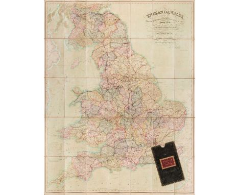
England & Wales. Walker (J & C), England & Wales founded upon the Grand Trigonometrical Survey, Shewing all the Mail Coach, Turnpike & Rail Roads, the Rivers & Navigable Canals, also the Boundaries & Divisions of Counties..., circa 1850, engraved map with contemporary wash colouring, sectionalised and laid on linen, slight staining and spotting, calligraphic title and table of explanation, 1300 x 1030 mm, contained in a contemporary green morocco gilt slipcase with red morocco gilt label to the upper cover, some wear to extremities, together with another copy similar (dated 1845) with some offsetting from the calligraphic title, contained in a contemporary cloth slipcase, with Wyld (James. successor to Mr Faden). A New Map of England & Wales Projected upon the Trigonometrical Operations made for the General Survey of the Kingdom, January 1st 1836, engraved map with contemporary wash colouring, sectionalised and laid on linen, table of the 'Altitudes of the Principal Mountains', and table of explanation, slight offsetting, edged in green silk, advertisement endpapers, 1250 x 950 mm, contained in a contemporary cloth slipcase with publisher's printed label to the upper cover, slipcase worn and frayed, plus Mogg (Edward). Map of the United Kingdom of Great Britain & Ireland with the adjacent parts of the Continent from Amsterdam to Paris and Brest..., January 1st 1834, engraved map with contemporary wash colouring, sectionalised and laid on linen, with an additional title above the map 'Mogg's Map of Steam Navigation', inset map of the Shetland and Orkney Islands, table of reference and compass rose, very slight staining, 770 x 610 mm, advertisement endpapers, contained in a contemporary blue card slipcase with publisher's printed label to the upper cover, slipcase worn and frayed at extremities, and Sayer (Robert). An Accurate Modern Map of England and Wales, drawn from the latest Surveys, Corrected & Improved by the Best Authorities, circa 1775, an engraved map with contemporary outline colouring, sectionalised and laid on linen, some staining and dust soiling, slight wear where old folds cross, 480 x 405 mm, contained in a contemporary marbled card slipcase with a near-contemporary manuscript ownership signature to the upper cover, slipcase worn and frayed, with Wyld (James). Wyld's Road Director through England and Wales being a New and Comprehensive Display of the Roads and Distances from Town to Town and of each Remarkable Place from London, 1851, lithographic folding map with contemporary outline colouring, laid on linen, slight offsetting, bound in contemporary cloth boards with publisher's label to the upper cover, some wear to extremitiesQTY: (6)
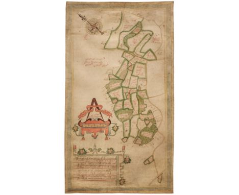
Los 52
Estate Plan. Boycot (Thomas). A mapp and Description of the mannor of hampton Liinge in the parish of braborne In Kent: with: 31: parcells of arrable and Pasture:; and: 12: Parcells of wood containing: 320: acrers noc Quarters:: 38: Peartches The: 31 Parcells of arrable and Pasture Contayne: 253: - 2 - 36: pertches: and the: 12 Parcells of wood Containe: 66 - 2 - D perchs, 1650, pen, ink and watercolour plan on vellum, compass rose, decorative distance scale surmounted by dividers, some dust soiling and creasing, 690 x 390 mmQTY: (1)NOTE:An unusually well-preserved mid-17th-century estate plan in the vicinity of Braborune, south-east Kent.This lot is subject to the Manorial Documents Rules 1959, 1963 and 1967, administered by The Historical Manuscripts Commission at The National Archives on behalf of the Master of the Rolls. Accordingly the purchasers of the documents lie under an obligation to notify the Secretary of the Commission of their acquisition and to provide details of where they will be kept. They may in no circumstances be removed from England and Wales without the prior consent of the Master of the Rolls.
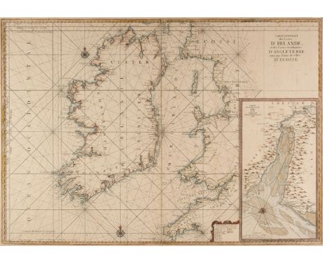
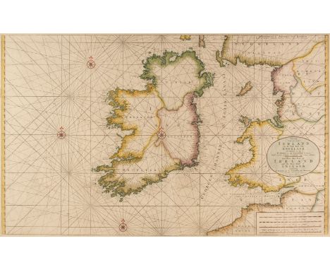
Los 74
Ireland. Van Loon (Hermanus.), Carte Generale des Costes D'Irlande et des Costes Occidentales D'Angleterre avec une Partie de celles D'Ecosse, [1661 or later], large hand-coloured sea chart of Ireland and the west coast of England & Wales, inset map of the River Dee and Chester, compass rose and numerous rhumb lines, narrow margins, slight spotting, 610 x 870 mm, together with Taylor (Alexander). A New Map of Ireland having the Great Features of the Country described in a Manner Highly Expressive..., New Edition, James Wyld, Successor to Mr Faden, June 1st. 1827, engraved map with contemporary wash colouring, sectionalised and laid on linen, decorative cartouche and dedication and table of references, toned overall short splits along old folds, one section torn and detached, 740 x 610 mm, contained in a near-contemporary cloth slipcase (not uniform with the map), the slipcase worn and rubbed, with Forster & Co. (publishers). Geological Map of Ireland to Accompany the Instructions to Valuators..., Sold by Hodges & Smith, Dublin, August 1853, colour-lithographic map, sectionalised and laid on linen, inset tables and cross-section, 515 x 360 mm, marbled endpapers and bound in contemporary cloth boards with publishers printed label to the upper cover, board size 145 x 100 mmQTY: (3)
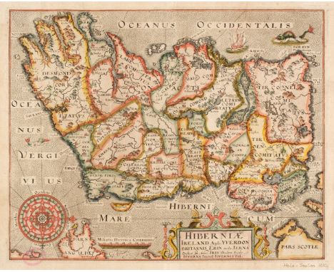
Los 69
Ireland. Hole (G.), Hiberniae, Ireland Anglis Yverdon Britannis Erin..., 1610, hand-coloured engraved map orientated to the west, strapwork cartouche and ornate compass rose, slight staining to the margins, sight creasing, old pink collector's stamp to verso (RWS) with slight show through just affecting the printed image, 270 x 340 mm, no text on verso, together with Morden (Robert). The Kingdom of Ireland [1695 or later], hand-coloured engraved map, 410 x 350 mmQTY: (2)NOTE:The collector's stamp is that of the late cartographic collector, author and academic Rodney W. Shirley.
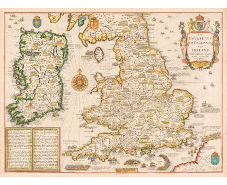
Los 48
England, Wales & Ireland. Speed (John), The Invasions of England and Ireland with al their Civill Wars since the Conquest, Thomas Bassett & Richard Chiswell, circa 1676, hand-coloured map, engraved by Cornelius Danckerts, large compass rose and numerous rhumb lines, good margins, 380 x 515 mm, English text on versoQTY: (1)NOTE:R. W. Shirley. Early Printed Maps of the British Isles, 1477 - 1650, number 397.
Los 45
England & Wales. Rocque (John), England and Wales Drawn from the most accurate surveys, Containing all the Cities, Boroughs, Market Towns and Villages..., circa 1794, large engraved map with contemporary outline colouring on two sheets not conjoined, large cartouche with later hand-colouring, inset map of the Scilly Isles, old folds, slight offsetting and spotting, overall size 1200 x 985 mm, together with Kitchin (Thomas). A New Map of England & Wales Drawn from Several Surveys &c. on a new Projection Corrected from Astronomical Observations..., The Canals inserted to 1792 by J. Phillips Surveyor, Laurie & Whittle, 12th May 1794, large engraved map with contemporary outline colouring on two sheets not conjoined, inset map of the Scilly Isles, large uncoloured decorative cartouche, the cartouche incorporates a coastal scene with a ship, a soldier and a sailor and a spread of artefacts representing British trades, including sheep, wheat and cannonballs, compass rose and table of remarks, slight dust soiling, old folds, overall size if conjoined 1275 x 1090 mmQTY: (4)
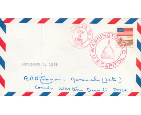
Los 193
WW2 SAS Gen Richard O'Connor DSO MC signed1981 US Washington DC FDC. General Sir Richard Nugent O'Connor, KT, GCB, DSO and Bar, MC (21 August 1889 - 17 June 1981) was a senior British Army officer who fought in both the First and Second World Wars, and commanded the Western Desert Force in the early years of the Second World War. He was the field commander for Operation Compass, in which his forces destroyed a much larger Italian army - a victory which nearly drove the Axis from Africa, and in turn, led Adolf Hitler to send the Afrika Korps under Erwin Rommel to try to reverse the situation. O'Connor was captured by a German reconnaissance patrol during the night of 7 April 1941 and spent over two years in an Italian prisoner of war camp. He eventually escaped after the fall of Mussolini in the autumn of 1943. In 1944 he commanded VIII Corps in the Battle of Normandy and later during Operation Market Garden. In 1945 he was General Officer in Command of the Eastern Command in India and then, in the closing days of British rule in the subcontinent, he headed Northern Command. His final job in the army was Adjutant-General to the Forces in London, in charge of the British Army's administration, personnel and organisation. Good condition. All autographs come with a Certificate of Authenticity. We combine postage on multiple winning lots and can ship worldwide. UK postage from £5.99, EU from £7.99, Rest of World from £9.99
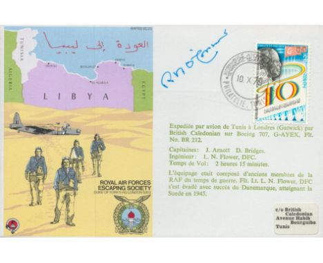
Los 178
WW2 SAS Gen Richard O'Connor DSO MC signed Escape from Tunisia RAF escaping society cover. General Sir Richard Nugent O'Connor, KT, GCB, DSO and Bar, MC (21 August 1889 - 17 June 1981) was a senior British Army officer who fought in both the First and Second World Wars, and commanded the Western Desert Force in the early years of the Second World War. He was the field commander for Operation Compass, in which his forces destroyed a much larger Italian army - a victory which nearly drove the Axis from Africa, and in turn, led Adolf Hitler to send the Afrika Korps under Erwin Rommel to try to reverse the situation. O'Connor was captured by a German reconnaissance patrol during the night of 7 April 1941 and spent over two years in an Italian prisoner of war camp. He eventually escaped after the fall of Mussolini in the autumn of 1943. In 1944 he commanded VIII Corps in the Battle of Normandy and later during Operation Market Garden. In 1945 he was General Officer in Command of the Eastern Command in India and then, in the closing days of British rule in the subcontinent, he headed Northern Command. His final job in the army was Adjutant-General to the Forces in London, in charge of the British Army's administration, personnel and organisation. Good condition. All autographs come with a Certificate of Authenticity. We combine postage on multiple winning lots and can ship worldwide. UK postage from £5.99, EU from £7.99, Rest of World from £9.99
-
36562 Los(e)/Seite