A George III silver cased compass, by J & W Watkins, London, mark TH (possibly Thomas Hodge), London 1787, with enamel dial, 4.8cm diameter Please note Roseberys do not guarantee the working condition of scientific instruments offered for sale. Please refer to department for condition report
36562 Preisdatenbank Los(e) gefunden, die Ihrer Suche entsprechen
36562 Lose gefunden, die zu Ihrer Suche passen. Abonnieren Sie die Preisdatenbank, um sofortigen Zugriff auf alle Dienstleistungen der Preisdatenbank zu haben.
Preisdatenbank abonnieren- Liste
- Galerie
-
36562 Los(e)/Seite
A George III brass and silvered surveyor's compass, by J & W Watkins, London, late 18th century, set in a mahogany case, the four-point compass rose signed J & W WATKINS, Charing Cross, London and with scale 0-360°, 13cm diameter, the case 15cm square Please note Roseberys do not guarantee the working condition of scientific instruments offered for sale.Please refer to department for condition report
A Regency mahogany cased surveyor's circumferentor, by J.Raxter, Birmingham, first-quarter 19th century, the silvered dial with eight-point rose and 0-360 scale, inscribed J.Raxter, Birm, on brass mounted tripod stand, 17cm square, tripod approx. 103cm total Note: Before the theodolite came into common use the instrument most often carried by Land Surveyors to measure horizontal angles was the circumferentor. This consisted of a large conventional compass, fitted with a pair of sights and mounted on a tripod. Despite its comparative lack of accuracy it continued to be preferred in America, and other heavily forested areas where the sight lines were more likely to be obscured. Please note Roseberys do not guarantee the working condition of scientific instruments offered for sale. Please refer to department for condition report
A silver cased pocket compass, by W & S Jones, first half 19th century, marks partially rubbed, the enamel dial with 32-point compass rose and outer degree scale, signed W & S JONES, HOLBORN LONDON, 5.5cm diameter Please note Roseberys do not guarantee the working condition of scientific instruments offered for sale.Please refer to department for condition report
A small George II bronze sundial plate, by Thomas Heath, London, second quarter 18th century, engraved with 8 point compass rose, hours marked with Roman numerals and divided by 10 minutes, the solid gnomon signed T.Heath London FECIT, 16.5cm square Note: Thomas Heath, a London instrument maker, worked from 1720-1753 at the sign of Hercules and Globe in the Strand. Please refer to department for condition report
A George III bronze 12 inch sundial plate, by Watkins & Smith, London, third quarter 18th century, engraved 16 point compass rose, hours marked with Roman numerals and divided by 10 minutes, signed Watkins & Smith, London, 30cm diameter Note: Francis Watkins the elder and Addison Smith, who was Watkins apprentice, worked at 5 Charing Cross. The partnership was dissolved in the 1770's.Please refer to department for condition report
A George III bronze 14 inch sundial plate, by Benjamin Martin, London, third quarter 18th century, engraved with 16 point compass rose, hours marked with Roman numerals and divided by 5 minutes, solid gnomon, signed B Martin LONDON, 35.5cm diameter Note: Benjamin Martin is recorded as working at South Street, Chichester, Sussex circa 1736-1740 and thereafter at London addresses until circa 1777.Please refer to department for condition report
A George III bronze 9 inch sundial plate, by George Adams, London, mid-18th century, engraved with 8-point compass rose, hours marked with Roman numerals and divided by 5 minutes, solid gnomon, signed G ADAMS At, No 60 Fleet St, LONDON, 23cm diameter Note: The signature Adams could refer to a number of instrument makers operating in London throughout the 18th century, including George Adams and his sons George (II). Please refer to department for condition report
An English bronze 10 inch sundial plate, by J Sisson, 18th century, engraved with 16 point compass rose, calendrical equation of time, hours marked with Roman numerals and divided by 10 minutes, solid gnomon, signed J Sisson, LONDON, 24cm diameter Note: The maker of the current lot is either Jonathan Sisson (1690-1747) or his son Jeremiah (fl.1747-1770), both notable makers of mathematical instruments, see Nicholas Goodison, English Barometers 1680-1860, Antique Collectors` Club, xxxxPlease refer to department for condition report
A Scottish George III bronze 15 inch sundial plate, by Miller & Adie, Edinburgh, early 19th century, engraved with 8 point compass rose, calendrical equation of time, hours marked with Roman numerals and divided by 10 minutes, pierced gnomon, signed MILLER & ADIE EDINBURGH, 38cm diameter Note: Alexander Adie was apprenticed to his uncle the eminent Scottish instrument maker John Miller in 1789. In 1804 his uncle took him into partnership trading under the name Miller and Adie. The business continued until Miller's death in 1815. Adie then continued operating under his own name, and later Adie & Son when his son joined the firm. Adie was particularly interested in meteorological instruments and is perhaps best known as the inventor of the Sympiesometer, a compact and lightweight type of barometer, in 1818. In recognition of his work he was elected a Fellow of the Royal Society of Edinburgh in 1819.Please refer to department for condition report
A Victorian polyhedral slate sundial, by Richard Melvin, dated 1856, the bronze gnomon set for Latitude 51 42 North (probably Coventry or nearby), with four subsidary dials for Morning New York N America, Afternoon Alexandria Egypt Africa, Evening Island of Borneo Asia and Night N Holand Australia, 8 point compass rose, calendrical equation of time, hours marked with Roman numerals and divided by 5 minutes instructions for use: To find the time of the several places names in this circle add the time past the meridian; subtract the time wanting,and To find Greenwich or Railway times: add 12 minutes to the time on the dial, signed RICH MELVIN Fecit AD 1856 and with motto Horas non numero nisi sernas (I could the bright hours only), 35.5 x 34cmNote: Melvin was based in Glasgow and he worked at Dargavel House, Pollock House, Aikenhead House and most notably for the pioneering Gothic Revival architect William Butterfield at Perth Cathedral and the Cathedral of the Isles. By the 1850s he had moved to Liverpool and his prestigious commissions included a dial at Ruthin Castle in Denbighshire for the Gothicist William Burges.Please refer to department for condition report
An English 4 inch terrestrial table globe, by Geographia, London, first quarter 20th century, printed label "GEOGRAPHIA" 4 INCH TERRESTRIAL GLOBE, Steamer route distances in Sea Miles, British Possessions Red, GEOGRAPHIA (1923) LTD, 55 FLEET STREET, LONDON, E.C.4, on an ebonised stand inset with compass, 24cm high Please refer to department for condition report
A brass Anglo-French octagonal pocket sundial and compass, by Michael Butterfield, Paris, c.1700, with hinged triangular gnomon cast as a bird calibrated in degrees for elevation to the outer edge, the underside showing latitudes for twenty French cities, signed BUTTERFIELD A PARIS, the glazed compass with baseplate inscribed with seven European cities and Premier Cadron, 6cm wideProvenance: A gift from Dr. Gwendolyn Pratt.Note: Michael Butterfield was born in England around 1635 but moved to France in around 1663 finally settling in Paris in 1677 where he established his workshops at Faubourg St-Germain, rue Neuve-des-Fossés trading under the sign 'arms of England'. In 1680 Butterfield was made 'Engineer of The King' and became associated through the likes of Huygens and Cassini with the Academy of Sciences from whom he received a coat of arms in 1698. In 1702 Butterfield was admitted as a freeman to the Founders Corporation. Michael Butterfield became one of the leading makers of instruments with products from his workshop including lodestones, graphometers, quadrants, graduated rulers, sectors, proportional compasses and various types of sundials. His reputation was such that he received patronage from Tsar Peter the Great in 1717. By this time Michael Butterfield was trading from the 'Le Quay de l'Horloge' where he was based until his death on 1724.Please refer to department for condition report
A Regency gilt brass pocket compass, by Berge, London, c.1820, the enamel dial marked in degrees and quadrants, signed on dial Berge, London, 6cm diameter Provenance: A gift from Dr. Gwendolyn Pratt.Please note Roseberys do not guarantee the working condition of scientific instruments offered for sale.Please refer to department for condition report
A Victorian mahogany stick tube barometer, by Ledger Smith & Co., London and Calcutta, c.1870, the wide arched glazed case with fretwork panel, enclosing enamelled scales and signature plate, scale down to 16†on right, heights in feet on left down up to 14960 at 18â€, manually adjusted pointer slide, Fahrenheit and Reaumur mercury thermometers each side of tube, Fitzroy directions ('Barometer Rises', 'Barometer Falls' etc.), a mother-of-pearl compass set at the bottom, the arched plate marked Ledger, Smith & Co., ST MARY AXE LONDON AND 21 STRAND, CALCUTTA, with registered trade mark KAISAR-I-HIND above and BAROMETER, 107cm high Note: Sir Nicholas Goodison notes: 'The fretwork suggest that this barometer was made for the Indian market'. Please note Roseberys do not guarantee the working condition of barometers offered for sale. This lot contains liquid mercury. If you intend to ship this overseas it is classified as hazardous cargo and will require additional declarations alongside specialist crating/packing. Prior to bidding, please contact your shipper or talk to our specialists for more information.
Channel Islands. Von Reilly (Franz Johann Joseph), Die Insel Jersey [and] Die Englaendischen Inselin an der Küste von Frankreich, Vienna, circa 1799, together two engraved maps with contemporary outline colouring, each approximately 205 x 340 mm, mounted, together with Collins (Captain Greenville). Untitled sea chart of the western tip of Cornwall and the Scilly Isles, circa 1790, hand-coloured engraved sea chart, 455 x 575 mm, with Sayer (Robert & Bennett J., publishers). A New Chart of Mounts Bay in Cornwall with the Adjacent Coast from Cape Lizard to Cape Cornwall, 1780, hand-coloured engraved sea chart, compass rose and numerous rhumb lines, five inset horizon profiles, 490 x 695 mm, plus Bonne (Rigobert). Carte Particuliere des Isles Jersey, Grenesy et Aurigny, circa 1770, engraved miniature map with contemporary outline colouring, inset map of Alderney, 105 x 130 mm, with two other similar by or after Lewis and Millar, various sizes, good condition QTY: (7)
Essex. Chapman (John, and André, Peter). A Map of the County of Essex from an actual survey taken in MDCCLXXII: LXXIII & MDCCLXXIV by John Chapman and Peter André, October 1st, 1777, large-scale engraved map of 25 sheets (complete, including the list of subscribers), plus the double-page key map, large compass rose, inset plan of Harwich Harbour and map of Colchester, slight spotting and offsetting, each sheet approximately 470 x 600 mm, 19th century half morocco gilt, with a heraldic motto and crest to the upper siding, worn and rubbed, folioQTY: (1)NOTE:Chapman and André's meticulously detailed and accurate survey of Essex resulted in the finest large-scale map of the county. It was the first to depict minor roads and included every country house and cottage, milestone, bridge, turnpike, creek, ferry, cliff and even a duck decoy. It is unlikely that more than 300 copies of the first edition were sold, though there was a second smaller edition issued in 1785.The crest on the front cover is that of Joseph Cockfield Dimsdale, 1st Baronet (1849 - 1912), a resident of Essex, knighted in 1894 and was Lord Mayor of London on the occasion of the coronation of Edward VII in 1902. He was created a Baronet and a Knight Commander of the Victorian order and was a Member of parliament from 1900 - 1906. His library was sold by Christie's in April 1913.
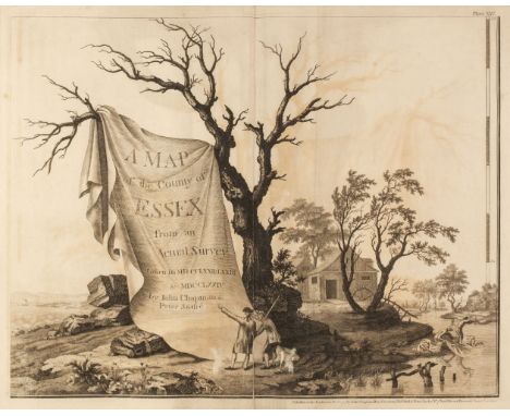
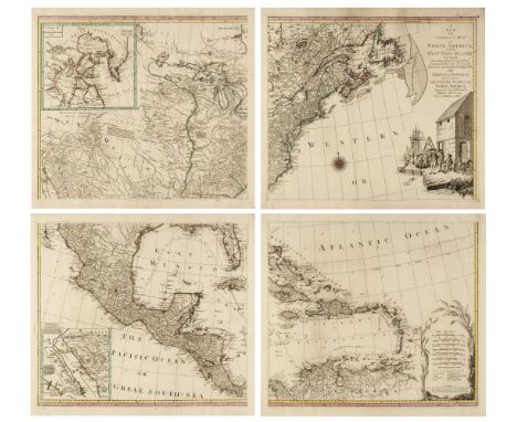
Greenwood (C. & J.). Atlas of the Counties of England made from Actual Surveys made from the years 1817 to 1833..., 2 volumes, 1834, calligraphic title with an engraved map of England & Wales, 41 (only) engraved double-page maps, with contemporary outline colouring, each with an ecclesiastical vignette, table of explanation, compass rose and calligraphic title, some damp staining affecting the lower part of the maps, each map re-guarded and backed with linen, slight dust soiling, creasing and spotting, a few maps trimmed to the neatline, map of Durham with long repaired closed tears and a small area of loss, each map approximately 590 x 690 mm, modern half morocco gilt with contrasting calf labels to spines, slight wear to extremities, folioQTY: (2)NOTE:The maps consist of Bedford, Berkshire, Buckinghamshire, Cambridge, Cumberland, Dorset, Durham, Essex, Gloucester, Herefordshire, Hertford, Huntingdon, Kent, Lancaster, Leicester, Lincolnshire, Middlesex, Norfolk, Northampton, Northumberland, Nottingham, Oxford, Rutland, Salop (Shropshire), Somerset, Southampton (Hampshire), Suffolk, Surrey, Sussex, Warwick, Westmorland, Wiltshire, Worcestershire, East Riding of Yorkshire, West Riding of Yorkshire, North Riding of Yorkshire, Glamorgan Brecon & Radnor, Anglesey Caernarfon & Merioneth, Flint Denbigh & Montgomery, Cardigan Pembroke & Caermarthen [and] Monmouth
Ireland. Speed (John), The Province of Connaugh with the City of Galwaye, Thomas Bassett & Richard Chiswell [1676], hand-coloured engraved map, inset town plan of Galway, large strapwork cartouche, compass rose and mileage scale, slight worming to the lower margins, 385 x 510 mm, English text on verso, mounted, framed and double-glazedQTY: (1)
North America. Lotter (M. A. & G. F.). A New and Correct Map of North America, with the West India Islands. Divided According to the last Treaty of Peace, concluded at Paris, the 20th. of Jan. 1783 wherein are particularly Distinguished the Thirteen Provinces wich (sic) Compose the United States of North America..., large engraved four-sheet wall map (not conjoined) with contemporary outline colouring, inset maps of Baffin & Hudson Bays and the Kino map of the land passage to California, compass rose and table of explanation, large uncoloured title cartouche of a wharf scene with merchants supervising slaves moving cargo, large margins, slight dust soiling, but confined to the margins, each sheet approximately 510 x 585 mm, if joined approximately 1020 x 1170 mm QTY: (4)NOTE:A scarce pirated edition of Thomas Pownall's map of 1755.
Poland. Plan von der neuen Festung Neyss wie solche der Konig von Preussen hat Fortificieren Lassen, circa 1750. large watercolour plan of the fortifications of the town of Neisse (Nysa), compass rose, distance table and inset cross-section of the ditches and ramparts, 475 x 685 mmQTY: (1)NOTE:Nysa is a town in southwestern Poland on the Eastern Neisse river. Nysa is one of the oldest towns in Silesia and its fortifications originate from 1350. These plans were probably drawn during the First Silesian War (War of the Austrian Succession) when in 1741 it was besieged and captured by the Prussians. King Frederick II of Prussia laid the foundations of its modern fortifications which saw action again in 1758 when it was besieged by the Austrians.
Sussex. Bowen (Emanuel), An Accurate Map of the County of Sussex Divided into its Rapes, Deanries and Hundreds, Drawn from Surveys..., John Sayer, Robert & Carington Bowles, circa 1765, engraved map with contemporary outline colouring, originally published in 'The Large English Atlas', inset panoramas of the north prospect of Chichester and the south prospect of Lewes, inset iconography of Chichester and Lewes, large decorative uncoloured cartouche and dedication, 515 x 690 mm, together with Greenwood (C. & J.). Map of the County of Sussex from an actual Survey, made in the years 1823 and 1824...., published July 4th 1829, map engraved by H. Frost with bright contemporary hand-colouring, calligraphic cartouche, compass rose, table of explanation and a vignette of Chichester Cathedral, additional horizontal fold, 590 x 720 mmQTY: (2)NOTE:Two unusually bright clean examples.
Sussex. Gardner (W. & Yeakell T & Gream T.), A Topographical Map of the County of Sussex divided into Rapes, Deanries and Hundreds, Planned from an Actual Survey by a Scale of one Inch to a Statute Mile, begun by W. Gardner and the late T. Yeakell, completed by Thos. Gream, Land Surveyor..., 1st. edition, W. Faden, 1795, large scale map with bright contemporary hand-colouring, engraved by Thomas Foot, sectionalised and laid on linen on four sheets, calligraphic cartouche and dedication and compass rose, slight offsetting and dust soiling, edged in green silk, overall size 785 x 1960 mmQTY: (1)NOTE:D. Kingsley. The Printed Maps of Sussex no. 57, One of the most important maps of Sussex and the first to be based upon a trigonometrical survey.
Wales. Mercator (Gerard & Lhuyd Humphrey), Cambriae Typus Auctore Humfredo Lhuydo Denbigiense Cambrobritanno, [1607 - 1633], hand-coloured map, engraved by Pieter Van den Keere, large strapwork cartouche, mileage scale and quarter compass rose, slight overall toning, 350 x 490 mm, Latin text on verso,QTY: (1)NOTE:John Booth. Antique maps of Wales, map no. 3.
A VICTORIAN WALNUT CASED MAW OF LONDON BRASS AND GLASS BREAST PUMP AND A SMALL QUANTITY OF OTHER SCIENTIFIC APPARATUS, ETC, the breast pump with name plaque 'MAW, 11 ALDERSGATE ST, LONDON' fitted in a velvet lined case, together with five Victorian microscope slides, a 19th century pocket compass / sundial in a turned wooden case, diameter 6.8cm, a Victorian gilt metal travelling candlestick, the pull off cover (on chain) engraved with coronet and initials, fitted with folding hooks to attach to a coach's upholstered interior, height 15.5cm, an early 20th century brass table top magnifying glass on adjustable stand, inscribed '1872 Stanley London' to the upright and 'Ross, 28 Bond Street, London 1887',to the underside, height of stand 25.5cm and a brass wall mount gimbal frame (10) (Condition report: the wooden cover on the compass has a split but the majority of other items are in reasonable condition)
Pair of US Army Signal Corps binoculars, by Bausch & Lomb Optical Co, in leather case with integral compass; a box containing gentleman's cufflinks, and personal effects including WWI medals presented to 5747 Pte. F. Mason 22-Lond.R., ; plus other items including Caithness vases, ceramic jugs, chess set, etc.
An interesting selection of collectables comprising:a set of four mid-20th century kitchen storage jars; a circular giltwood-mounted ceramic tile (as a table top); a modern cased C.F. Casella & Co. No. 1963 spirit level;a W. M. Tapp compass;a large 19th century salt-glaze stoneware pitcher (26.5 cm high);two 19th century bottles (one marked 'J. Schweppes & Co. - .52 Berners Street' and the other 'Arnold Perrett & Co - Wickwar'
A polished hardstone-style handled desk set comprising two unengraved seals, a letter opener, a fountain pen and a propelling-pencil. Together with further bijouterie to include including a pear-shaped carved Chinese jadeite pendant, an early 20th century hallmarked silver button hook and a compass. (small selection)
Derbyshire, John Speed: 'Anno Darbieshire described', hand coloured engraved map, [1676], Thomas Bassett & Richard Chiswell, inset town plan of Derby and a view of Buxton, large strapwork cartouche and compass rose, some wear and possible strengthening at central fold, approx 38.5 x 51cm, framed and glazed, the whole approx 50 x 63cm

-
36562 Los(e)/Seite