36562 Preisdatenbank Los(e) gefunden, die Ihrer Suche entsprechen
36562 Lose gefunden, die zu Ihrer Suche passen. Abonnieren Sie die Preisdatenbank, um sofortigen Zugriff auf alle Dienstleistungen der Preisdatenbank zu haben.
Preisdatenbank abonnieren- Liste
- Galerie
-
36562 Los(e)/Seite

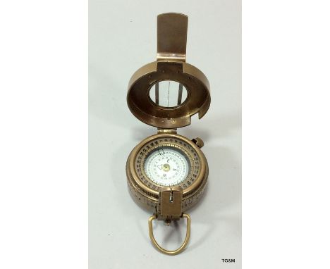
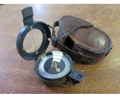
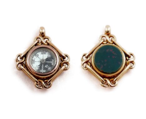
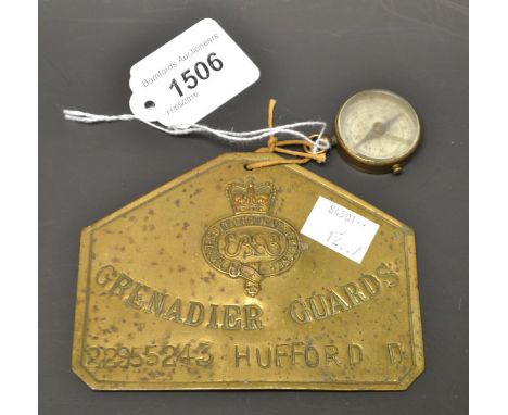
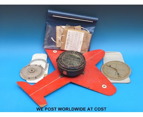
Los 1121
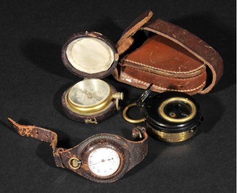
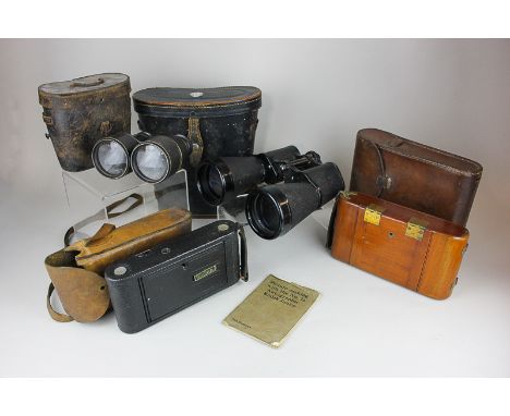
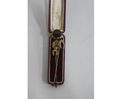
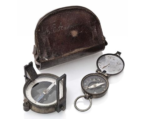
*WWI Compass. An officer's compass by Negretti & Zambra, with hinged eyepiece, various stamps including 'Patents 1818/15 103019/16', in its brown leather case, together with a WWI gunmetal timepiece with circular white enamel dial, Arabic numerals, gold hands and subsidiary dial contained in a brown leather wrist strap (as used by officers), plus a Victorian gilt metal compass with silvered dial signed L. Casella London, in a brown leather carrying case (3)
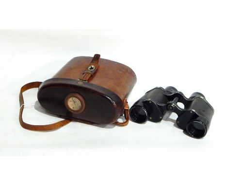
Los 845
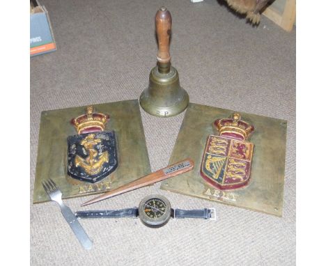
*Pilot's Compass. A WWII German pilot's wrist compass, the circular dial inscribed 'Kadlec Instrumenfabrik', stores stamps to back plate, Werk Nr 11438, with leather strap, together with an ARP brass bell, additionally stamped 'Fiddian' with wooden handle, 26 cm high, Third Reich aluminium fork with Wermacht eagle, stamped 'W.S.M 41 Rostfrei', 18 cm long, pair of cast iron plaques for Army & Navy, 26 x 24 cm, plus a treen letter opener from HMS Ajax (Battle of the River Plate) (6)
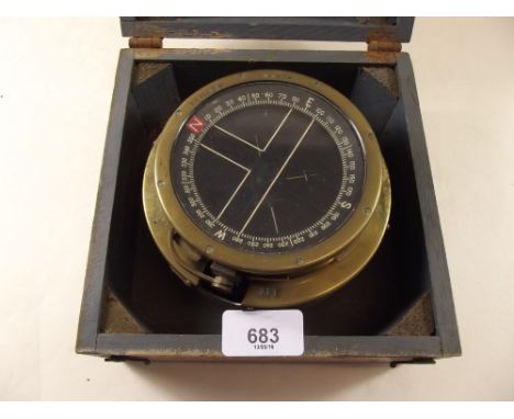
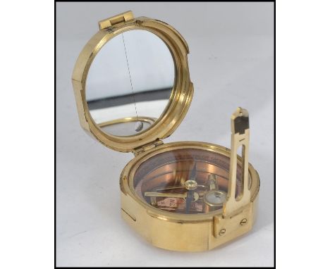
Los 866
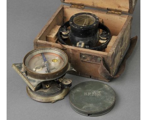
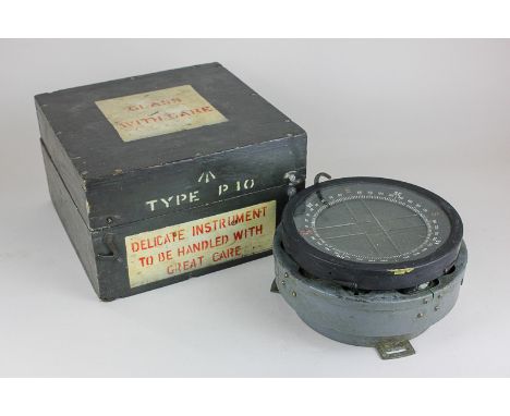
*Royal Flying Corps. A Mark II 259 pattern flight compass, with suspension frame, sprung adjustors, stamped on the viewing window PATT. 259 A MARK II No 1755, 13cm diameter, in a pine box, the lid printed Patt 25 9 A Mark II with original paper label for Admiralty compass Observatory Slough (compass mechanism dislodged), together with a WWI German Foot Artillery Gun Sight by C.P Goerz, Berlin, the circular silver dial with detachable compass, stamped N. C.P. Goerz, Berlin B.R.2898 Fussartillerie S, with brass cover (2)
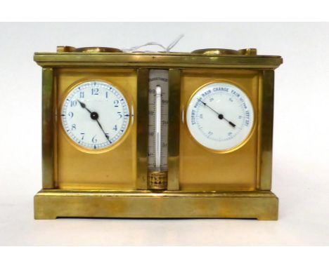
Los 177
* A brass compendium desk timepiece, circa 1910, carrying handle, combined timepiece/compass/barometer/thermometer, single barrel movement with a silvered platform lever escapement, 15cm high over handle26.04.16, Case surfaces are discoloured, back glass panel with small chips, timepiece dial with the signature rubbed, enamel dials with no cracks, movement needs cleaning.
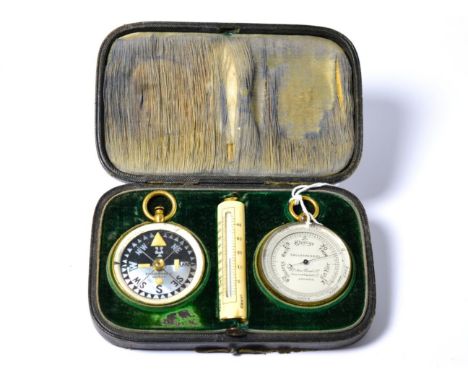
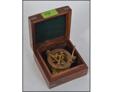
Los 563
A Compendium cased aneroid barometer/compass/thermometer, retailed by Callaghan & Co, New Bond Street, London, circa 1900, gilded barometer and compass cases, ivory cased thermometer, in a fitted case 25.04.16, Both gilded cases with staining marks and rubbed areas, compass glass is cracked, inner silvered ring is discoloured to the compass, barometer hand is moving when doing the plastic bag test, thermometer in good condition, outer fitted case with scuff marks to the exterior, inside the lid is worn and green velvet is worn in parts.
Los 456
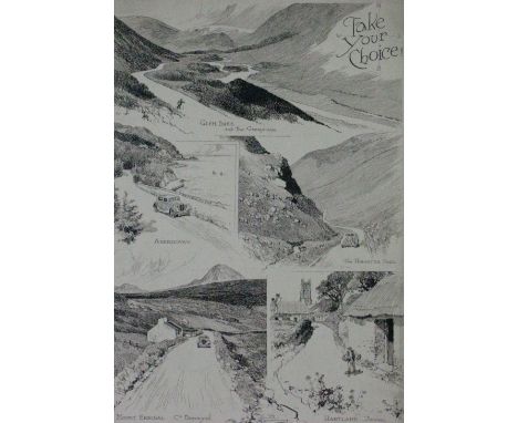
*Take Your Choice. Depicting five scenes, three of which include motorcars: Glen Shee and the Grampians; Aberdovey; The Honister Pass; Mount Errigal, County Donegal; and Hartland, Devon, inscribed with the main title (and points of the compass) top right, signed and dated 1937 bottom centre, and annotated in pencil 'Favourite Touring Haunts' in the top margin and 'Motor Thursday' in the bottom margin, sheet and image size 17 3/4 x 12 1/2 ins (44 1/2 x 31 cm), some marginal soiling, with the image somewhat affected, so would benefit from a clean (1)
Los 175
Birmingham. Sherriff (James), A Map of Upwards of 25 Miles round the Town of Birmingham..., published Jas. Sherriff & Wm. Faden, 1798, large engraved map with contemporary outline colouring, sectionalised and laid on linen, decorative uncoloured cartouche and mileage scale, table of explanation and compass rose, slight spotting, 845 x 705 mm Uncommon. (1)
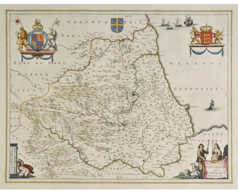
Los 181
Durham. Blaeu (Johannes), Episcopatus Dunelmensis vulgo The Bishoprike of Durham, published Amsterdam, circa 1645, engraved map with contemporary hand colouring, 385 x 500 mm, French text on verso, together with, Jansson (Jan), Episcopatus Dunelmensis vulgo The Bishoprike of Durham, published Amsterdam, circa 1650, engraved map with contemporary hand colouring, ornate cartouche, compass rose and numerous rhumb lines, slight overall toning, 405 x 510 mm, French text on verso, with another copy framed and glazed, plus another twenty-three county maps and town plans including examples by Blome, Saxton/Kip, Morden, Pigot, Cary, Duncan, Dawson, Lewis, Fullarton, Hinton, Bowen and Kitchin, some duplicates, various sizes and condition (26)
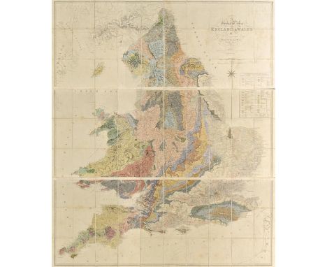
Los 182
England & Wales. Greenough ( G.B.), A Geological Map of England & Wales by G.B.Greenough, President of the Geological Society..., 1819 [but published 1820], engraved map with contemporary hand colouring, on three sheets, sectionalised and laid on linen, compass rose and table of explanation, some staining, each sheet approximately 640 x 1620 mm, contained in a marbled book box, worn A map which was controversial at the time of its publication in that Greenough was accused of plagiarising William Smith's earlier and ground breaking geological survey and map of 1815. Greenough was stung enough by the critisicm to issue a written defense of his actions which was published in 'Memoir of a Geological Map of England: to Which are Added, an Alphabetical Index to the Hills, and a List of the Hills Arranged According to Counties (1820), p4.'.Smith's low social staus and background resulted in his work being largely ignored and the Geological Society of London did indeed plagiarise the map, undercutting Smith's asking price, which eventually pushed Smith to financial ruin and the debtor's prison. Recognition of his role as 'The Father of English Geology' would only follow much later in 1831 when Smith was awarded the Woolaston medal by the Geological Society. Greenough's map is important in its own right and is now recognised as a separate piece of scholarship but unlike Smith it involved no surveying but relied on other surveyors sending him information which he then collated. (1)
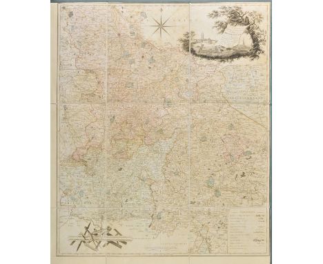
Los 185
Essex. Greenwood (C & J), Map of the County of Essex from an Actual Survey made in the Year 1824..., published Greenwood & Pringle & Co., [1825], large uncoloured engraved map on six conjoined sheets, calligraphic cartouche, engraved vignette of Audley End House, table of explanation and compass rose, occasional marginal closed tears, one split along old fold, folds strengthened on verso, old adhesion stains on verso, 1275 x 1520 mm (1)
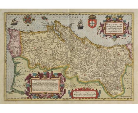
Los 214
Portugal. Mercator (Gerard & Hondius Jodocus), Portugalliae Que Olim Lusitania, Novissima et Exactissima Descrtiption Auctore Vernando Alvaro Secco..., circa 1610, engraved map by Baptista van Doetecum, with contemporary hand colouring, three ornate strapwork cartouches, compass rose and rhumb lines, slight oxidisation to old watercolour causing slight cracking, repaired on verso, 335 x 495 mm, German text on verso One of the most attractive maps of Portugal and one of the few maps engraved for Hondius by Baptista van Doetecum. The map is a based upon Alvares Secco's map of 1561. (1)
Los 223
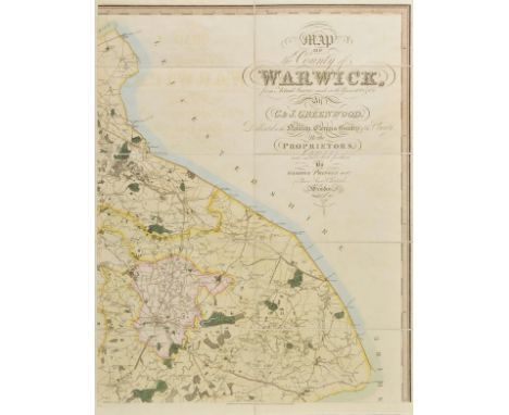
Warwickshire. Greenwood (C. & J.), Map of the County of Warwick from actual Survey made in the years 1820 & 1821 by C. & J. Greenwood, Dedicated to the Nobility, Clergy & Gentry of the County by the Proprietors and Published for them by George Pringle Junr. 1822, engraved map with contemporary hand colouring, sectionalised and laid on linen, on four sheets, calligraphic title, table of explanation, compass rose and uncoloured vignette of Warwick castle, very slight offsetting, edged in blue linen, 1320 x 1050 mm, contained in modern blue cloth slip case with morocco gilt label to spine (1)
Los 62
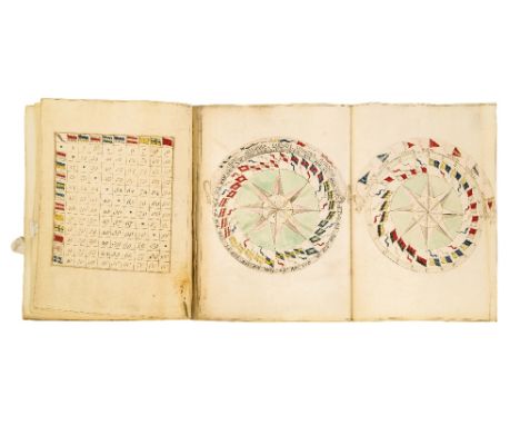
NAVAL SIGNAL BOOK (HARBOUR SIGNALS, SEA SIGNALS, NIGHT SIGNALS AND FOG SIGNALS), 2 vol, manuscript on vellum, 35 and 25 leaves (including 19 blank), exquisite hand-coloured manuscript frontispiece of a trophy of flags and geographical instruments, folding leaf containing two watercolour drawings of compass diagrams, some of the tables with flags painted in watercolour. Both in contemporary calf, blindstamped decoration round the sides, small 4to, -- 6¼ x 4¾in. (15.5 x 12cm.), contained in their original red straight-grained morocco wallet binding with flap, on the flap a small oval silver plaque inscribed: Honble Captn P. Bertie., Captain Peregrine Francis Bertie (1741-1790) was the third son of the Earl of Abingdon and commissioned a lieutenant in 1759, being made post captain in 1762 when he commanded the first-rate ship Repulse. He entered Parliament as MP for Oxford in 1774 and later went to sea again in the 1780s, commanding H.M.S. Fortitude and H.M.S. Carnatic. His son-in-law was Sir Thomas Bertie (1758-1825), a friend and contemporary of Nelson who would rise to the rank of Admiral.,
Los 63
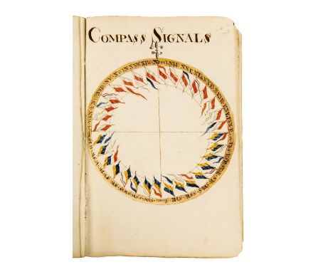
SIGNALS TO BE OBSERVED BY THE SQUADRON UNDER THE COMMAND OF REAR ADML. LEVESON GOWER, ENGLISH, CIRCA 1788, 36 leaves, (including two final blanks), 75 exquisitely drawn and hand-coloured manuscript signals including the full-page of 'Compass Signals' with 32 hand-coloured flags, contemporary (?original) printed wrappers, stitched as issued, 8vo (15 x 10cm.), John Leveson Gower (1740-1792), naval officer and politician entered the navy and was commissioned lieutenant in 1758. His naval career prospered until 1779 but he was unemployed for three years. In January 1783 he was appointed a junior Lord of the Admiralty. He returned to the navy in 1785 and in 1787 was promoted to rear-admiral of the Blue. Demanding of his subordinates, loyal to his friends and harsh to his enemies, Admiral John Leveson Gower showed himself to be a resourceful and thoroughly competent officer in every command he held, ODNB. This little book contains about 216 signals.
Los 172
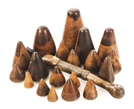
Ø A COLLECTION OF TREEN, comprising: a small oak tiller inscribed to top MARY HANNAH in the form of an alligator with ropework arm clasping a ball; two fids; a set of 19 lignum vitæ plumbers' turn pins; a cased set of boxwood naval architects' shapes, each stamped ER 1865; a beam compass; a wooden level; a saw, two wood and brass spirit levels and a small model of a spirit level; together with a small anchor -- tiller 19in. (48cm.) long, (a lot)
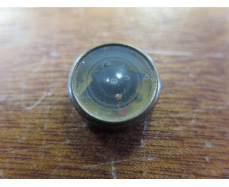
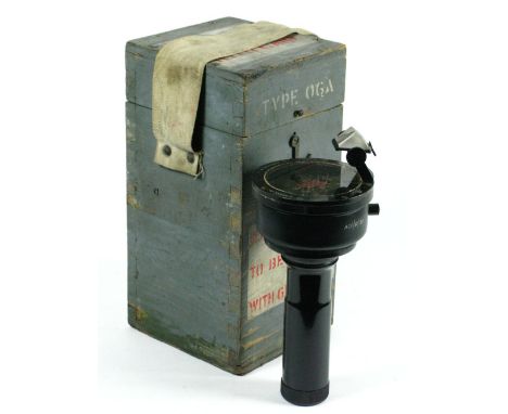
Los 184
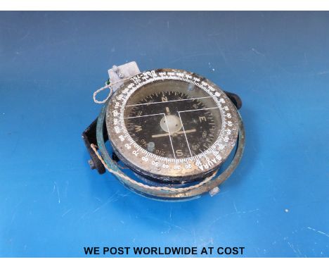
AN EARLY 20TH-CENTURY SIGHTING COMPASS, unsigned, the aluminium compass ring stamped in reverse, half blued steel needle with steel pivot and locking clamp, in brass drum case with folding sighers and threaded handle, leather case with belt loops, scratch inscribed A.B. Amundsen, the case -- 6in. (12.5cm.); together with pocket marching compass, (2), This compass was discovered in a lifeboat located in New Zealand, any connection to the famous explorer Roald Amundsen has yet to be made.
Los 194
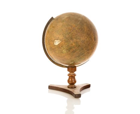
A 12IN. CELESTIAL GLOBE PUBLISHED BY G.F. CRUTCHLEY, LONDON CIRCA 1850, hand-painted gores signed as per title and inscribed Crutchley's Late Cary's New Celestial Globe ..., mounted through the Colurus Aequinoctium line with calibrated brass meridian on turned wood stand with tripod foot -- 18in. (45.5cm.) high; together with late 19th-century 12in. terrestrial globe by John Haywood, Manchester, London, mounted on turned stand with inset compass to base, (2),
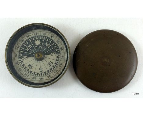
Los 197
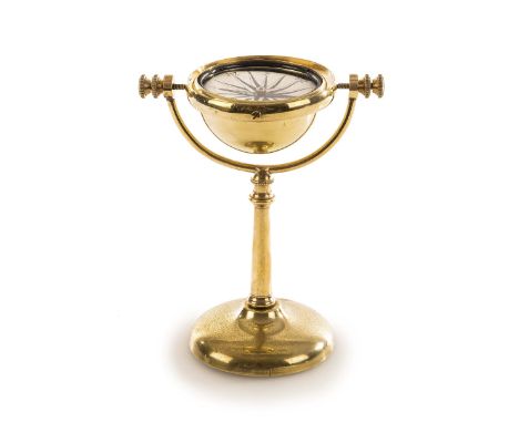
A 19TH-CENTURY LACQUERED BRASS GIMBALLED DRY CARD CONTINENTAL DESK COMPASS, with 2¾in. paper dial stamped Logia within weighted brass bowl set within gimbal rings attached to tapering support with flared foot base -- 7½in. (19cm.) high; together with a finely observed nickel plated model anchor inscribed 'Anvers', (2)
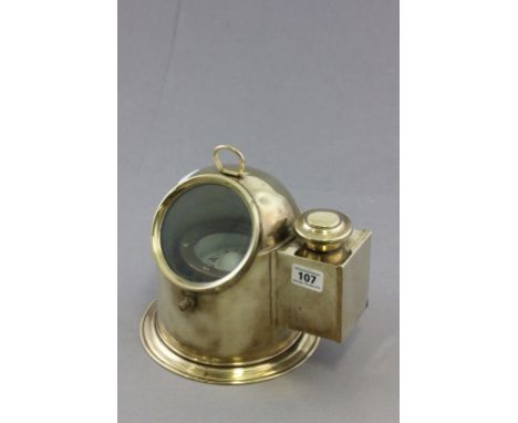
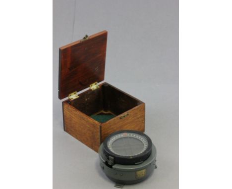
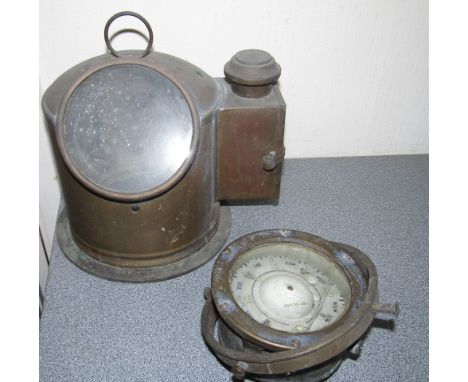
Los 198
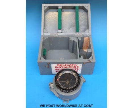
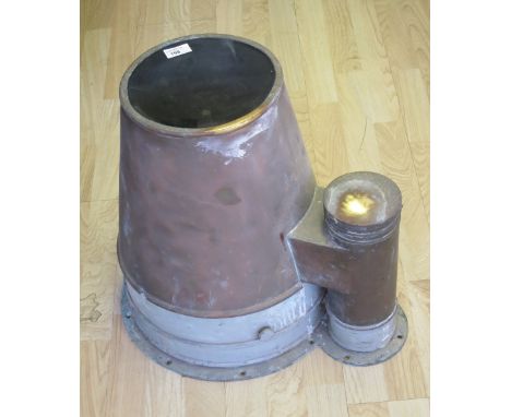
A BINNACLE COMPASS, BY H.S.M.I. CO., HULL, the 7in. reverse-printed translucent card signed as per title and mounted within a liquid-filled gimballed bowl, mounted within a brassed hood with side light housing and top glass -- 18in (45.5cm.) high, Provenance: Purchased from the MoD in 1990.,
Los 199
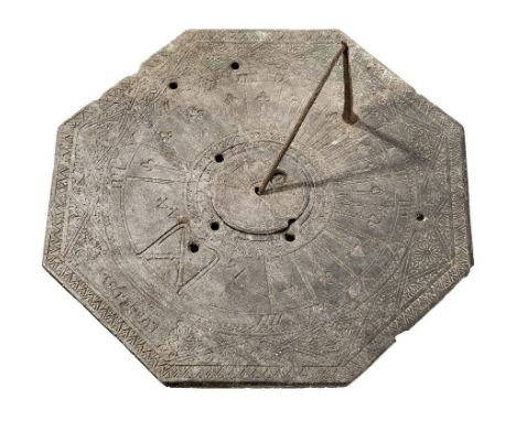
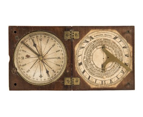
A FINE LACQUERED BRASS SUNDIAL BY HENRY SHUTTLEWORTH, LONDON, CIRCA 1770, engraved to a latitude of 55° (Newcastle or Londonderry) with finely worked sixteen-point compass rose, outer minute scale, perspective radiused Roman hour numerals recording IIIIam to VIIIpm each separated by a decorative fleur-de-lys motif, signed at south Shuttleworth London, gnomen, three threaded pad feet, (retaining much original lacquered finish and black-waxed filling) -- 10in (25.5cm.) high, Literature: Turner, A: Early Scientific Instruments Europe 1400-1800, Sotheby's 1987, p.176, this dial illustrated fig. 182, Henry Raines Shuttleworth (w. 1760-1797) was apprenticed to the famous London Maker John Cuff in 1746. Made a Freeman of the Spectacle Makers Company 1756 he subsequently established his own Mathematical Shop near the west end of St. Paul's in Ludgate Street. Succeeded by his son, (also Henry, apprenticed to his father 1778) in Ludgate Street 1797-1811. His signature denotes some of the finest London mathematical instruments of the period.,
Los 201
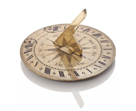
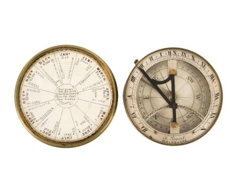
AN 18TH-CENTURY COMPASS SUNDIAL BY BENJAMIN MARTIN, LONDON, the 3¼in. silvered dial with finely engraved compass rose, blued steel hand, lacquered brass case, hinged latitude, horizon ring signed B. Martin Fecit with folding gnomon, contained within a lined morocco case (later) approximately -- 6in. (15cm.) square, Benjamin Martin worked between 1738 and 1777 from one address in Chichester and five in Fleet Street and latterly as Benjamin Martin & Son until 1782 when the firm went bankrupt.,
Los 206
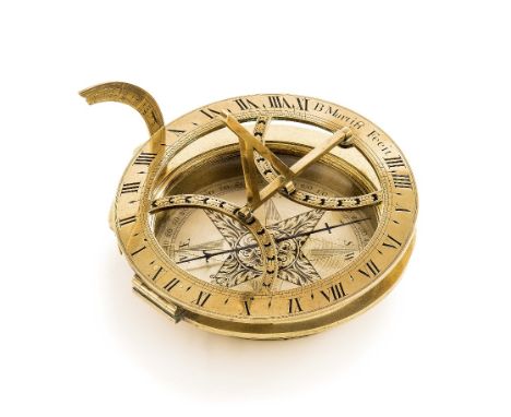
A RARE POCKET SUNDIAL BY T. GAUNT, MELBOURNE, CIRCA 1890, paper compass rose with steel needle and clamp, silvered chapter ring signed as per title, folding oxidised gnomon, the lid with printed equation of time, contained within original leather carry case with strap -- 3¾in. (9.5cm.) diameter, Thomas Gaunt (1829-1890) was born in London and moved to Melbourne, Australia, in 1852. He was known as a manufacturer of turret clocks, a dealer and repairer of instruments and, rather eccentrically, also made ecclesiastical jewellery.
Los 213
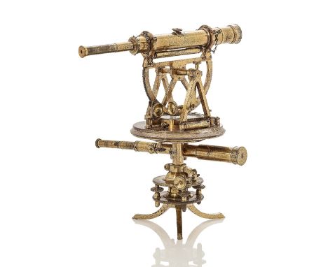
A RARE AND FINE DOUBLE THEODOLITE BY MATTHEW BERGE, LONDON, FORMERLY OWNED BY THOMAS, FIRST BARON DUNDAS, GOVERNOR OF THE FORTH AND CLYDE CANAL COMPANY AND PROMOTOR OF WILLIAM SYMINGTON'S STEAM BOAT TRIALS, CIRCA 1805, constructed in lacquered brass with silvered scales, signed and inscribed on the main plate M. Berge, London / Lord Dundas, bubble levels, compass with jewelled pivot, telescope with blanking nut, lower telescope mounted on separate axis, secondary base with screw levelling and threaded removable tripod feet, contained within original fitted shaped wooden box of issue with two telescope tubes, adjusting instrument and key -- 14½ x 11½ x 8¼in. (37 x 29x 21cm.), Thomas, Lord Dundas (1741-1820) the educated and well-connected "nabob of the north" was a hugely significant figure in Scottish and Northern English politics and culture almost until the day he died. As a friend of the Prince of Wales, Lord Dundas enjoyed an active social life, being a member of Brooks's Club, the United Service Club, the Society of Dilettanti and the Society of Antiquaries. From 1793 to 1813 he was the effective commander of the Yorkshire militia, and was Lord Lieutenant and Vice-Admiral of Orkney and Shetland between 1794 and 1820. An enthusiastic agricultural improver, he spent his income from rents on draining and enclosing land, experimenting with new crops and breeds and building water- or horse-powered threshing mills. As governor of the Forth and Clyde Navigation Company (1786-1816), he presided over the canal's completion and the creation of Grangemouth and Port Dundas. He also persuaded the company to test the first practical steam-tug, the Charlotte Dundas - named for a daughter. Despite its early promise, concerns over bank erosion were not addressed and the project foundered. Matthew Berge succeeded Jesse Ramsden in 1800 and for a time signed his instruments "Berge, Late Ramsden". This example has a more flamboyant signature now obscured by a plate securing knob and had to be re-signed underneath, but was probably used by Dundas until he stepped down as Governor of the Canal in 1813.
-
36562 Los(e)/Seite