36562 Preisdatenbank Los(e) gefunden, die Ihrer Suche entsprechen
36562 Lose gefunden, die zu Ihrer Suche passen. Abonnieren Sie die Preisdatenbank, um sofortigen Zugriff auf alle Dienstleistungen der Preisdatenbank zu haben.
Preisdatenbank abonnieren- Liste
- Galerie
-
36562 Los(e)/Seite


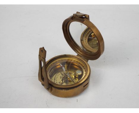

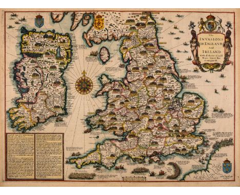
Los 279
British Isles.- Speed (John) The Invasions of England and Ireland with al their Civill Wars Since the Conquest, First edition, decorative title cartouche surmounted by royal arms, upper right, naval battles in the Channel and North Sea, numerous land battles, large compass rose, arms of Scotland, Ireland and France, a text panel lower left, engraved map by Cornelius Danckerts, with hand-colouring, platemark 390 x 520 mm (15 1/4 x 20 1/2 in), sheet 413 x 557 mm (16 1/8 x 21 7/8 in), English text verso, central vertical fold with careful repairs to splitting verso, marginal nicks and tears, small marginal loss to upper left, some even toning with light exposure lines outside of borderline, unframed, George Humble, [1627-1632]
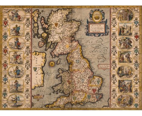
Los 280
British Isles.- Speed (John) Britain as it was devided in the tyme of the Englishe Saxons especially during their Heptarchy, decorative map of the British Isles with compass rose and numerous rhumb lines, fourteen engraved vignettes of historical scenes and Saxon kings to the vertical margins, engraving with hand-colouring, on laid paper with watermark of fleur-de-lis, 385 x 510 mm (15 1/4 x 20 in), under glass, English text verso, central vertical fold with careful repairs and parallel creasing visible, marginal nicks and tears repaired verso, surface dirt, framed, Bassett & Chiswell, [1676].
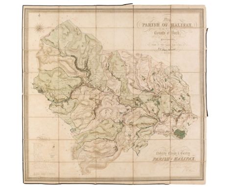
Los 107
Halifax. Myers (J. F.), Map of the Parish of Halifax in the West Riding of the County of York, Shewing the Township Borough & Manorial Boundaries, from an Actual Survey Made in the Years, 1834 and 1835, by J. F. Myers, Surveyor, Halifax, circa 1835, large scale engraved map with contemporary hand colouring, sectionalised and laid on linen, calligraphic title and dedication, compass rose and a table of references, some light dust soiling and staining, 1075 x 1135 mm,QTY: (1)
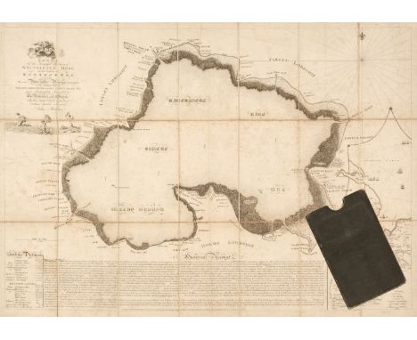
Los 110
Huntingdonshire. Bodger (John), A Chart of the Beautiful Fishery of Whittlesea Mere, in the County of Huntingdon: and of such navigable rivers with which it has communication from their spring heads to their influx into the sea..., sold by the proprietor John Bodger, Stilton, Mr Debrett Piccadilly & Mr Boydell Cheapside London, 1st May 1786, uncoloured engraved map, sectionalised and laid on linen, inset map of the environs of the country surrounding the mere, calligraphic cartouche, compass rose and numerous rhumb lines, sailing distances and an extensive description of the mere's history below the map, some spotting and staining, 470 x 670 mm, contained in a contemporary cloth slipcase with a printed label to the spine, some wear to the extremitiesQTY: (1)NOTE:A scarce, separately published angling map. Only two copies recorded on Copac.
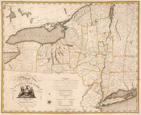
Los 127
New York State. De Witt (Simeon), A Map of the State of the State of New York by Simeon De Witt, Surveyor General, Contracted from his Large Map of the State, New York, 1804, engraved map with contemporary outline colouring, large inset title cartouche and compass rose, old folds, some adhesion scaring to verso, a few folds strengthened and repaired on the verso, slight marginal fraying and creasing, 565 x 690 mmQTY: (1)NOTE:Ristow. American Maps and Mapmakers, pages 73-83. Rare. Copac lists only one institutional copy (British Library), although we have found other copies at Yale and The Centre for Brooklyn History.
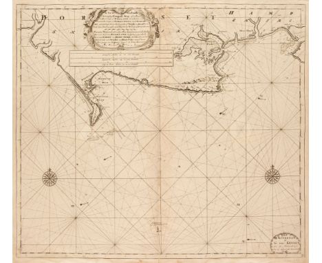
Los 145
Sea Charts. Van Keulen (Gerard), A New Gradually Encreasing Compass Map of a Part the Sea Coasts of England in which is contained the Coasts of Dorsetshire and Hampshire, extending from the West side of Wight to Bridport with their Shallownesses and Depths by Nicholas de Vries Geome, Amsterdam, [1698 or later], uncoloured engraved sea chart, decorative cartouche, two compass roses and numerous rhumb lines, two small closed repaired tears, slight staining and toning, slight fraying to the margins, 525 x 595 mm, together with Collins (Captain Greenville). Six sea charts [1693 or later], six charts, five with later hand-colouring of The Isle of Portland, Burlington Bay, Aberdeen, St Georges Channel, Yarmouth and Kingsale Harbour, each approximately 455 x 575 mm, various conditionQTY: (7)
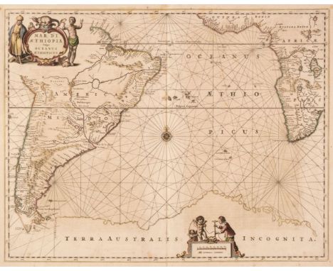
Los 147
South Atlantic Ocean. Jansson (Jan), Mar Di Aethiopia vulgo Oceanus Aethiopicus, circa 1660, engraved map with contemporary outline colouring, ornate cartouche and mileage scale, compass rose and numerous rhumb lines, slight staining and spotting, margins strengthened on verso, central fold partially split at the base, crudely repaired on verso, 440 x 550 mm, German text on versoQTY: (1)NOTE:Published in Jansson's 'Atlas Maritimus'.
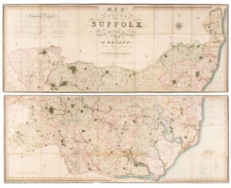
Los 150
Suffolk. Bryant (Andrew), Map of the County of Suffolk from actual survey by A. Bryant in the years 1824 and 1825..., published March 1st. 1826, large-scale engraved map with contemporary outline colouring, sectionalised and laid on linen, on two sheets, calligraphic title and compass rose, list of ecclesiastical divisions and table of explanation, some staining to lower sheet with very slight fraying, each section edged in green silk, green endpapers, overall size approximately 1510 x 1955 mmQTY: (1)
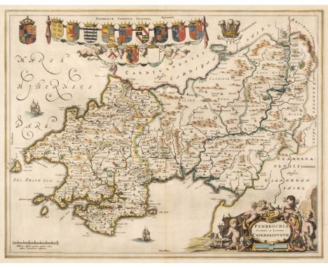
Los 154
Wales. Blaeu (Johannes), Penbrochia comitatus et comitatus Caermaridunum, Amsterdam, circa. 1648, engraved map with contemporary outline colouring, central fold strengthened and repaired on verso, 415 x 530 mm, Latin text on verso, together with Glamorganensis comitatus vulgo Glamorgan Shire, Amsterdam, circa. 1645, uncoloured engraved map, one small rust mark to the margin, but not affecting the printed image, 385 x 505 mm, French text on verso, with Jansson (Jan). Principatus Walliae pars Australis vulgo South-Wales, Amsterdam, circa 1650, uncoloured engraved map, decorative cartouche and mileage scale, slight creasing and staining, slight marginal fraying, 415 x 525 mm, French text on verso, plus Ogilby (John). The Continuation of the Road from London to St. Davids Comencing at Monmouth & Extending to Burton Ferry co. Glamorgan..., circa 1676, hand-coloured engraved strip road map, slight creasing, 335 x 355 mm, and Greenwood (C. & H.). Map of the County of Monmouth from an Actual Survey made in the years 1829 & 1830..., 1831, map with contemporary wash colouring, engraved by Josiah Neele, calligraphic title, table of explanation, compass rose and an uncoloured vignette view of Tintern Abbey, slight offsetting, 560 x 710 mm, with another three engraved maps of Monmouthshire and South Wales by Edward Weller and John Cary, and a sea chart of Milford Haven by Captain Greenville Collins, various sizes, good conditionQTY: (9)
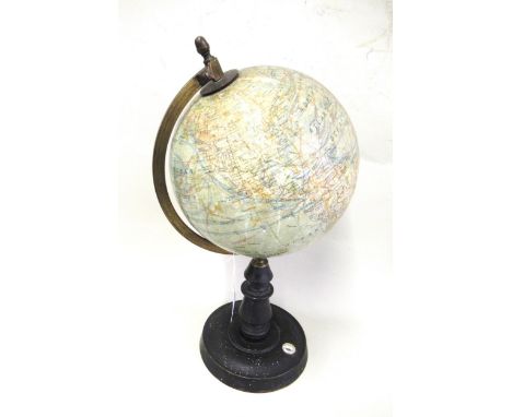
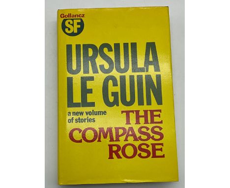
![* Wales. Speed (John), Montgomery Shire, John Sudbury & George Humble, 1st edition [1611], hand-coloured engraved map, in](https://cdn.globalauctionplatform.com/2a43871f-d280-4166-9f6c-af8800c0bef7/5ebc6448-6560-426e-8e1f-af8900a98ac4/468x382.jpg)
Los 157
* Wales. Speed (John), Montgomery Shire, John Sudbury & George Humble, 1st edition [1611], hand-coloured engraved map, inset town plan of Montgomery, large strapwork cartouche, compass rose and mileage scale, 385 x 515 mm, framed and double-glazed, English text on verso, together with The Countie of Radnor Described and the Shyre Townes Sittuatione, John Sudbury & George Humble, 1st edition [1611], hand-coloured engraved map, inset town plan of Radnor, strapwork cartouche, compass rose and mileage scale, slight toning to the central fold, 385 x 510 mm, framed and double-glazed, English text on verso, with Breknoke both Shyre and Towne Described, John Sudbury & George Humble, circa 1627, hand-coloured engraved map, inset town plan of Brecknock, large strapwork cartouche and mileage scale, 385 x 505 mm, framed and glazed, no text on verso, plus Denbighshire, Thomas Bassett & Richard Chiswell [1676], hand-coloured engraved map, inset town plan of Denbigh, 380 x 515 mm, framed and double-glazed, English text on versoQTY: (4)
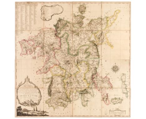
Los 159
Worcestershire. Taylor (Isaac), To The Right Honourable Earl of Coventry, Lord Lieutenant & Custos Rotulorum of this County...., This Map of the County of Worcester is most Humbly Dedicated by their Obedient and most Humble Servant, Isaac Taylor, Ross-on-Wye, 1772, large scale engraved map with contemporary outline colouring, sensationalised into 16 pieces, each laid on to later card, each with a manuscript number, decorative uncoloured cartouche and mileage scale, compass rose, table of explanation set within a floriate border and a 'list of places taken from the Land Tax book', slight dust soiling, each sheet 255 x 255 mm, overall size if conjoined, approximately 1020 x 1020 mm, contained in a contemporary marbled card slipcase, the case is heavily worn, frayed and split along the jointsQTY: (1)NOTE:A rare example of one of Isaac Taylor's fine large-scale county maps.
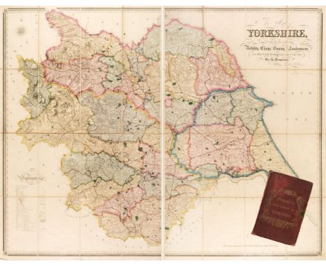
Los 161
Yorkshire. Hobson (William Colling), This Map of Yorkshire is most respectfully dedicated to the nobility, clergy, gentry, landowners and manufacturers of the county, 1847, large engraved map on two sheets, with bright contemporary outline colouring, engraved by J. & C. Walker, sectionalised and laid on linen, calligraphic title, compass rose and table of explanation, slight staining, each sheet approximately 1250 x 790 mm, bound in contemporary morocco boards with elaborate gilt title to the upper siding, lacking half of the metal clasp, worn and rubbed at extremitiesQTY: (1)
-
36562 Los(e)/Seite