WW2 RAF Escape and Evasion tunic button compass, when the base section is unscrewed opens to reveal a concealed compass, button marked on back 'BUTTONS Ltd B'HAM', together with five regular RAF buttons & a Royal Artillery Regiment tunic button converted in to a sweet heart brooch. (7) * Condition: In very good condition, compass with clear undamaged glass.
36562 Preisdatenbank Los(e) gefunden, die Ihrer Suche entsprechen
36562 Lose gefunden, die zu Ihrer Suche passen. Abonnieren Sie die Preisdatenbank, um sofortigen Zugriff auf alle Dienstleistungen der Preisdatenbank zu haben.
Preisdatenbank abonnieren- Liste
- Galerie
-
36562 Los(e)/Seite
British Isles. Knipe (James A.) Geological Map of the British Isles and part of France, Showing also the Inland Navigation by means of Rivers and Canals, The Railways and Principal Roads and Sites of the Minerals, under the Patronage of His Royal Highness the Prince Consort..., 1870, revised 1871, engraved map with contemporary hand colouring, sectionalised and laid on linen on four sheets, inset map of the Orkney and Shetland islands, table of geological reference, table of explanation, nine geological cross sections, compass rose and calligraphic title, some staining, each sheet approximately 780 x 650 mm, contained in a contemporary morocco gilt book box with 'envelope style' lid with the royal coat of arms to the upper board, a little worn at extremities (1)
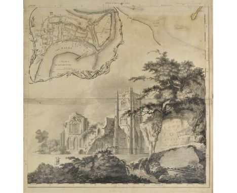
Yorkshire. Jefferys (Thomas), The County of York Survey'd in MDCCLXVII,VIII, IX and MDCCLXX, 1st edition, published T.Jefferys, 1772, large engraved map, sectionalised on to twenty sheets, sparse contemporary outline colouring, each sheet backed with later linen, decorative cartouche, large engraved vignette of Middleham Castle with dedication, table of references, compass rose and inset town plans of York, Scarborough, Leeds, Sheffield, Kingston-upon-Hull and Ripon, reduced index map of the County of York, slight dust soiling and occasional staining, a few sheets trimmed with slight loss, later endpapers, book plate of Keighley public library, library label to front endpaper, contemporary half morocco gilt with gilt title 'Maps of Yorkshire' to upper siding, worn and frayed at extremities, slim folio (1)
British Isles. Jansson (Jan), Britannia prout divisa temporibus Anglo-Saxonum praesertim durante illorum Heptarchia, [1646 or later], hand coloured engraved map, fourteen inset panels of Saxon kings and historical scenes, elaborate cartouche, compass rose and numerous rhumb lines, repaired marginal closed tears, slight creasing, central fold strengthened on verso, 420 x 520 mm, German text on verso R. W. Shirley. Early Printed Maps of the British Isles 1477 - 1650, no. 577. (1)
England & Wales. Willdey (George), A new and correct map of England & Wales now called South Britain, done from the latest surveys and best observations. Containing all ye cities & market towns with ye roads & distance in reputed miles between town & town by inspection without scale or compass..., circa 1717, engraved map with contemporary outline colouring on two conjoined sheets, tables of towns and cities and eighteen uncoloured vignettes of principal cities to vertical margins, old folds and central fold strengthened on verso, slight tape staining at base of folds, 620 x 1010 mm R. W. Shirley. Printed Maps of the British Isles 1650 - 1750. Willdey 3. An uncommon distance map of England, based on the John Adams wall map of 1677. (1)
A small collectors' lot to include a brass Stanley London pocket compass/sundial (af), a military compass 'Magnetic Marching Mk 1', marked 'B198077' by T.G. Co Ltd, a mother of pearl handled pocket knife, a further smaller similar example, two further pocket knives and a small quantity of military-related badges and buttons.
Box of assorted china to include: Hamilton collection limited edition animal plates, commemorative cups and saucers, Carlton Ware rouge royale dish, part teawares including Midwinter, together with Japanese lacquered compass/calendar in box etc. Together with additional box of ceramics, Vernal pattern pedestal dish, floral bouquets, Coalport pottery vases etc. (2)(B.P. 24% incl. VAT)
A Georg Jensen silver brooch, in a looped abstract design, detailed Georg Jensen 925 S Denmark 321, a Victorian silver pendant, formed as two crossed rowing oars, with a compass, Birmingham 1883, with a silver ropetwist link neckchain and further mostly silver jewellery, comprising; a pale blue gem set necklace, two pendants with neckchains and a grey tinted cultured pearl woven link bracelet, (6).
Various Instruments including E R Watts Sighting Compass in leather case, Fowlers Long Scale Calculator with instructions in leather case, Otis Kings Pocket Calculator, with instructions in original box, Salter Spring Balance (30lbs), Preston & Sons Spirit Level, Trough Compass, E R Warrs Miners Dial (damaged, cased); John Harris - The Description and Uses of the Celestial and Terrestrial Globes (4th Edition) dated 1713; and a Tribrach

-
36562 Los(e)/Seite