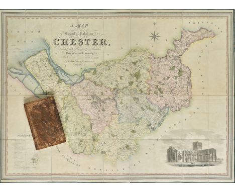
36562 Preisdatenbank Los(e) gefunden, die Ihrer Suche entsprechen

Verfeinern Sie Ihre Suche

Jahr

Sortieren nach Preisklasse
  • Liste
  • Galerie
  • 36562 Los(e)
    /Seite

Los 138

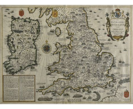
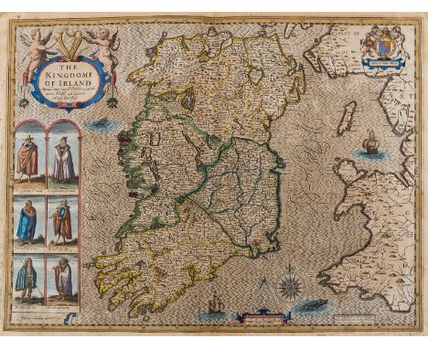
Ireland.- Speed (John) The Kingdome of Irland Devided into Severall Provinces, and the againe Devided into Counties. Newly Described, decorative map with strapwork title cartouche flanked by putti, the Royal coat of arms, sea monsters, sailing ships, and a compass rose, with vignettes of people of the region at the lower left, including 'The Gentleman and Gentlewoman of Ireland', 'The Civill Irish man and woman', and 'The Wilde Irish man and woman', engraving on laid paper with indistinct watermark, sheet 420 x 550 mm. (16 1/2 x 21 3/4 in), central vertical fold with careful old repairs to splitting, spotting and some toning to sheet, surface dirt, unframed, Sudbury and Humble, [1612].

Los 131

British Isles.- Speed (John) Britain as it was Devided in the Tyme of the English Saxons especially during their Heptarchy, decorative map of the British Isles with compass rose and numerous rhumb lines, fourteen engraved vignettes of historical scenes and Saxon kings to the vertical margins, engraving with hand-colouring, 380 x 510 mm. (15 x 20 in), English text verso, central vertical fold with careful repairs to splits, cockling and creases running from this, with one or two small fine parallel splits carefully restored, the upper edge with small areas of minor loss and splits to sheet extremity, framed, [circa 1676]

Los 146

England & Wales.- Walker (John) Map of the Inland Navigation, Canals, and Rail Roads with the Situations of the various Mineral Productions throughout Great Britain, large detailed folding map with calligraphic title and dedication, compass rose and table of explanation, and inset map of Scotland in the upper right, engraving with outline hand-colouring, 1940 x 1580 mm. ( 76 1/4 x 62 1/4 in), dissected and mounted on linen, off-setting, browning and surface dirt, edged with green linen, folding with marbled ends, presented in contemporary red morocco book-style slipcase, gilt and blind tooled, rubbed and worn, 4to, 1830.

Los 249

A German Third Reich pennant, with an eagle above a swastika, approx. 25.5 cm wide, and a pair of field glasses, inset a compass, and with faux crocodile skin mounts, cased (2)

Los 106

A cased compass from a Lancaster Bomber which was forced to land after being shot (story to bottom of case). Condition reports are not available for our Interiors Sale

Los 73

* Pocket compass. A pocket sundial and compass by Frances Barker circa 1875, the yew wood case hinged to reveal circular paper dial with blued steel needle, original paper label to inner lid, inscribed 'Reece' on base and lacking gnoman cord , 2cm high x 5cm wide x 7.5cm deep (Qty: 1)NOTESFrances Barker (1819-1875) founded the company Frances Barker & Son in 1848 based in Edenbridge, Kent, they specialised military grade electro-optical products, search and location equipment, educational material and radio electronics becoming notable as precision equipment suppliers to allied forces during the Great War and WWII.

Los 74

* Pocket compass. A pocket sundial and compass by Francis Barker circa 1875, the yew wood case hinged to reveal circular paper dial with blued steel needle, original paper calender to inner lid, some scratches to the case and lacking gnoman cord, 2cm high x 5.5cm wide x 7.5cm deep (Qty: 1)

Los 259

A Victorian silver Ludgate pocket watch, J W Benson, London 1884, white enamelled dial with Roman numerals and subsidiary seconds dial, engraved marks and numbers 27832 and 4658, on a silver chain with compass fob, 5.5cm diameter, 38cm long

Los 400

A pair of Harrison sovereign scales in leather case, together with novelty violin case vesta case, knife sharpener and a compass, F Barker and Son

Los 872

A BOXED BRASS CAPTIN CABIN MAP READER/ COMPASS AND MAGNIFYING GLASS

Los 474

Hallmarked sterling silver 30cm total length In vintage condition Signs of age & wear Dog clip in good working order compass not working See photographs

Los 338

A collection of bone and ivory cased pocket knives and others, manicure and sewing tools, 19th century and later, jewellery boxes, a T G Co Ltd No. B202457 1942 MK III compass, Solo wristwatch and a few others items (qty).

Los 244

A WORLD WAR ONE BRITISH ARMY OFFICER'S BRASS PRISMATIC COMPASS, MARKED F-L88467, 1917, LEATHER CASE AND A VICTORIAN BLACK PAINTED BRASS POCKET BAROMETER, THE SILVERED DIAL INSCRIBED DOLLOND LONDON, MAKER'S MAROON MOROCCO CASE

Los 190

World War Military Interest - Cambridge Dial Thermometer; other gauges; Negretti and Zambra gauge; War Issue Air Compass Type; Night Lights; etc

Los 215

A Zenit camera, a pair of Super Zenith binoculars and a prismatic compass

Los 106

* Lancashire. Saxton (Christopher & Hole G.), Lancastriae comitatus Palatinus olim pars Brigantum, [1637], hand coloured engraved map, large strapwork cartouche, compass rose and mileage scale, slight creasing, 300 x 310 mm, mounted, framed and glazed, together with Saxton (Chrisopher & Kip W.). Wiltoniae Comitatus herbida Planieie nobilis vulgo Willshire pars olim Belgarum, circa 1610, hand coloured engraved map, 285 x 375 mm, mounted, framed and glazed, with Morden (Robert). Somersetshire, circa 1701, hand coloured engraved map, old folds, 175 x 210 mm, mounted, framed and glazed, plus Badeslade (T. & Toms W. R. ). A map of Oxfordshire North West from London [and] A Map of Kent South East from London, A Map of Leicestershire North of London, 1742, together three hand coloured engraved maps, each approximately 150 x 150 mm, mounted, framed and glazed and Kitchin (Thomas). Cornwall from an actual survey and regulated by Astronl. Observatns., circa 1760, hand coloured engraved map, inset map of the Isles of Scilly, trimmed to neatline and tipped on to later paper, 195 x 230 mm, mounted, framed and glazed, with another seven county, regional and road maps, with examples by Cary, Owen & Bowen, Senex and Luffman, various sizes and condition, all framed and glazed (Qty: 14)

Los 129

* Oxfordshire. Plot (Robert), The Map of Oxfordshire, [1677], [1677], hand coloured engraved map, decorative cartouche, mileage scale, table of explanation and compass rose, old folds, slight creasing, slight overall toning, 500 x 480 mm, mounted, framed and glazed (Qty: 1)NOTESCreated by the first keeper of the Ashmolean Museum of Oxford, the map is decorated with 172 coats of arms of the county's gentry, Oxford colleges, the city and the four county towns. One of the most decorative maps of Oxfordshire ever produced.

Los 146

Sanderson (George) To the Nobility, Clergy, Gentry, Professional Gentlemen and Public in General, this Map of the Country Twenty Miles Round Mansfield, Comprehending Parts of the Counties of Nottingham, Derby, York, Lincoln and Leicester, showing the fields and characteristic features of the district from actual surveys made in the years 1830, 1831, 1832, 1833 & 1834..., published Mansfield Nottinghamshire, July 10th 1835, monumental circular wall map, engraved by J. & C. Walker, on four sheets, sectionalised and laid on linen, with contemporary hand colouring, calligraphic title, compass rose, table of explanation and an engraved vignette of Newstead Abbey, some staining causing slight fraying to paper, each sheet 1135 x 1140 mm, contained in a contemporary morocco gilt book-box, box worn and frayed and lacking base (Qty: 1)

Los 148

Shropshire & Staffordshire. Jansson (Jan), Salopiensis comitatus cum Staffordiensi. Shropshire & Staffordshire, circa 1650, engraved map with contemporary outline colouring, decorative cartouche and mileage scale, central fold partially split and repaired on verso, 430 x 535 mm, Dutch text on verso, together with Greenwood (C. & J.). Map of the County of Salop from an actual Survey made in the Years 1826 & 1827, published 1830, engraved map with contemporary hand colouring, large calligraphic cartouche, compass rose, tables of reference and explanation, uncoloured vignette of Shrewsbury, very slight offsetting, occasional marginal closed tears, 580 x 690 mm (Qty: 2)

Los 153

Shropshire. Speed (John), Shropshyre described, The Sittuation of Shrowesbury shewed with the Armes of thos Earles and other memorable things observed, published Roger Rea [1662], hand coloured engraved map, inset town plan of Shrewsbury, large strap-work cartouche and compass rose, very slight staining and worming, 385 x 510 mm, no text on verso (Qty: 1)

Los 154

* Somerset. Jansson (Jan), Comitatus Somersettensis, Somerest-Shire, circa 1638, hand coloured engraved map, ornate strapwork cartouche and mileage scale, compass rose and numerous rhumb lines, slight text show-through, 385 x 505 mm, mounted, framed and double glazed, German text on verso, together with Saxton (Christopher & Kip William). Somersettensis Comitatus vulgo Somersett Shyre qui olim pars suit Belgarum, [1610], hand coloured engraved map, large strapwork cartouche and mileage scale, 285 x 390 mm, mounted, framed and glazed (Qty: 2)NOTESThe first described item is in the scarce 'pre-atlas' state printed before the addition of the six coats of arms and a re-working of the title cartouche.

Los 157

Sussex. Figg (William), Map of the County of Sussex from an Actual Survey made in the Years 1823 & 1824, Corrected to the present time by William Figg F.S.A. Surveyor, Presented to the Subscribers to The Sussex Express, Surrey Standard & Kent Mail by the Proprietor William Edwin Baxter, Lewes,1861, calligraphic title, lithographic map with bright contemporary hand colouring, sectionalised and laid on linen on six sheets, table of explanation, compass rose, reference to the hundreds and a large uncoloured vignette of Chichester cathedral, each sheet approximately 640 x 700 mm, marbled endpapers, contained in a contemporary morocco gilt slip case, spines repaired, some wear to extremities (Qty: 1)NOTESOriginally published by C. & J. Greenwood in 1825.

Los 159

* Waghenaer (Lucas Janszoon). Zee Caerte van Engelants Eijndt, Alsoe hemtselsde Landt verthoont beginnede van Sorlinges tot Pleymondt, [1586], engraved hand coloured sea-chart of Cornwall, elaborate ornamental title cartouche, separate scale of distance surmounted by open dividers, royal crest, compass rose and rhumb lines, decorated with several sailing ships, sea monsters and land animals, 330 x 520 mm, Latin text to verso, mounted, framed and double glazed (Qty: 1)NOTESFrom the Latin edition of Waghenaer’s landmark atlas of sea charts “Spieghel der Zeervaerdt”, or the 'Mirror of the Sea'. The atlas, which was originally published in Dutch in 1584, was translated into Latin in 1586.

Los 163

Yorkshire. Tuke (John), Map of the County of York by John Tuke, Land Surveyor, MDCCLXXXVII, [1787], engraved map with contemporary outline colouring, sectionalised and laid on linen on four sheets, inset town plan of Kingston upon Hull, inset map of the county showing the Roman roads, large decorative coloured cartouche, compass rose and table of explanation, slight dust soiling and staining, trimmed to neat-line with thread margins, overall size 1190 x 1420 mm, contained in a contemporary marbled card slipcase with manuscript label to upper cover, slipcase heavily worn and frayed (Qty: 1)

Los 79

Cheshire. Swire (W. & Hutchings W.F.), A Map of the County Palatine of Chester, Divided into Hundreds & Parishes from an accurate survey, made in the years 1828 & 1829, published Henry Teesdale, 1830, large scale map engraved by J. Dower with bright contemporary hand colouring, sectionalised and laid on linen, calligraphic title, compass rose, table of reference and an uncoloured vignette of the south west view of Chester cathedral, slight offsetting, edged in green silk, marbled endpapers with decorative book-plate of John Ireland Blackburne and dated 1874, 960 x 1320 mm, contained in a contemporary marbled calf book-box, box heavily worn and frayed (Qty: 1)

Los 89

* England, Wales & Ireland. Speed (John), The Invasions of England and Ireland with al their Civill Wars since the Conquest, published George Humble, circa 1627, published George Humble, circa 1627, hand coloured engraved map by Cornelius Danckerts, decorative cartouche, compass rose and numerous rhumb lines, slight text show-through, some creasing, central fold partially repaired on verso, 385 x 520 mm, mounted, framed and double-glazed, English text on verso (Qty: 1)NOTESShirley. Early Printed Maps of the British Isles, 1477 - 1650, no. 397.

Los 194

Victorian hallmarked silver compass charm, verso a seascape scene, Birmingham 1881, 2.4cm diameter

Los 1535

A natural Sine compass, smaller example, Everite and Rotary watches etc 

Los 425

German Imperial. WW1 Kaiserliche Marine Ship’s Gimble Compass.A rare black painted brass example made by Steder of Kiel. The compass is numbered 1822. Housed in its stained pine box, the front and sliding lid with an Imperial Crown “M” and number 1825. Good clean condition. The vendor states the compass was acquired by a family member present at Scapa Flow 1918/1919.

Los 491

WW2 Period RAF / SOE Escape & Evaision Silk Maps and Compass. Comprising: Silk map J3/J4. Printed double sided showing Italy ... Map 43 E showing, Croatia, Germany, Italy etc ... Miniature Escape Compass with four hole pattern compass rose. Overall GC (3 items)

Los 61

A brass cased natural sine compass by Stanley of London in fitted box

Los 309E

Praktica EE2 camera body, Aires Penta 35 camera, another camera, Telegraph Works Silvertown of London compass and a Ohmmeter marked 'Edelmann of Munchen' (5) 

Los 279

Bezique and Polish Bezique card maker's game in original box, Oriental counters, two silver pill boxes, miniature compass, pocket watch, etc (1 box) 

Los 88

Sundries: including jeweller's anvil vice , military compass by S. Morden & Co, glass bottle seal, Medieval thimble, etc

Los 14

A gold micro mosaic brooch, depicting a bouquet of flowers, cracks to the panel, rub set to frame with ribbon motifs at the compass points, to hinged pin and 'C' catch, tested as approximately 18ct gold, 71 x 61mm, together with a 9ct gold Hirco mechanical watch, with gilt metal bracelet, and a gilt metal Medana mechanical watch with enamelled bezel (3)

Los 59

A silver miniature purse, together with a silver threepence, a silver sovereign case, a silver miniature bottle, a silver compass, and a collection of silver Vesta cases, etc

Los 12

A Reproduction Brass Marine Hand Held Compass in Brass Mounted Box

Los 250

Ingersoll Yankee Radiolite watch with silver fob compass & an Olimpia pocket watch 

Los 107

Russian army cap with badges, two handheld telescopes, compass in wooden box with plaque "Titanic 1912" etc.

Los 70

Box of military related items, a German Oigee gun sight, brass compass, a T. Walker "Cherub" brass ship-log, etc

Los 439

A George IV Masonic copper baluster ale jug with plain loop handle. Engraved with a square and compass and inscribed (indistinct) Brother Richard Holmes, to the Lodge of Antiquity, No. 294 Decr' 25th 1820, 24cm. Fabulous riveted patch repair under the spout. Wear. Some dents.

Los 311

TRAY CONTAINING JUBILEE CROWNS, COMPASS, PEN KNIVES ETC

Los 341

A quantity of costume jewellery etc including miniature compass, hat pins, painted fan, jet pendant, bone beads etc.

Los 178

Sue Atkinson (b.1949) ''Checking the Compass'' Signed, acrylic on board, 29.5cm by 27cm Artist's Resale Rights/Droit de Suite may apply to this lot, please refer to our Terms of Business

Los 811

A LATE 19TH CENTURY MAHOGANY CASED POCKET COMPASS, the square case with hinged cover, silvered circular dial. Case 7cm square

Loading...Loading...
  • 36562 Los(e)
    /Seite

Kürzlich aufgerufene Lose