Small collectibles including a Sundo altimeter, Ever Ready wooden torch, small brass spirit level by Rabone in original leather case, Starrett Speed indicator, cased, two miniature distance measuring devices, brass measuring instrument in leather case, engineer's directional compass, Simba referee timer, boxed, small loupe, two brass boxes (12).
36562 Preisdatenbank Los(e) gefunden, die Ihrer Suche entsprechen
36562 Lose gefunden, die zu Ihrer Suche passen. Abonnieren Sie die Preisdatenbank, um sofortigen Zugriff auf alle Dienstleistungen der Preisdatenbank zu haben.
Preisdatenbank abonnieren- Liste
- Galerie
-
36562 Los(e)/Seite
Four assorted 19th Century Sunderland lustre footed bowls comprising one with scenes of 'The Mariner's Compass' and 'A West View of the Cast Iron Bridge over the River Wear, built by R. Burdon Esq', diameter 25.5cm, one with various transfer applied and hand tinted vinaigrettes to include 'New Bridge over Teewear at Sunderland', diameter 24.5cm, another smaller similar example, diameter 21.5cm and the last with printed verse and 'Manchester Unity Independent under of Odd Fellows', diameter 15.5cm, all with damages
*RAF Compass. WWII Air Ministry hand compass Type 06, standard grey finish stamped with Air Ministry markings, No.15801.D. 6A/0.473, wooden handle, 23cm long, together with a mixed collection of aviation items including an RAF P.8 compass, with original wooden box dated 1942, a Bombsight "D" with Air Ministry markings, 10cm diameter, aircraft clock dated 1939, altitude meter dated 1941 plus headsets and receivers (8)
*Compass & Binnacle. WWII German Kriegsmarine ships compass, by G Plath Hamburg, serial no. 3525, with Kriegsmarine eagle stamp, with composite compass ring stamped '13184' with liquid filled glass dome, aluminium casing and bulkhead fixings stamped 'SK 3057/6v, approximately 31cm diameter, together with brass binnacle (1)
A C W Dixey London pocket combination barometer, thermometer and compass, of circular form, the one side with thermometer and compensated barometer, numbered 1093, the other side with screw off compass with mother of pearl dial, the white metal case with suspension loop to the top and being engine turned, in a leather covered double opening case
WW1 Royal Artillery Officer’s Attributed Binoculars & Compass.Comprising: British 1917 dated binoculars, these contained in a polished leather case dated 1916. Both case and binoculars with the name Brinkworth RFA. Clean. ... Accompanied by a military marching compass, contained in polished brown leather case. This with ink name “N.A. Hood RA” Some service wear. (2 items)Attributed to 2Lt Sydney George Skeate Brinkworth who was commissioned on the 21st December 1917 and landed in France 27th February 1918. ... Attributed to Lt Col Neville Albert Hood CMG DSO Royal Garrison Artillery.
WW2 RAF / SOE Agent Issue Escape Cigarette Lighter.A rare example of the official MI9 issue cigarette lighter issued to RAF aircrew and SOE Agents. Black metal body, which conceals an escape compass to the base. Overall GC the exterior retains all original black painted finish. PLEASE NOTE the inner lid which conceals the compass is absent.
WW2 Royal Australian Air Force Small Escape and Evasion Tunic Button CompassA rare original WW2 issue example appertaining to be an ordinary pocket size brass tunic button, embossed with a crown, retaining traces of blackened finish, indicating RAAF issue. When the base section is unscrewed opens to reveal a concealed miniature compass. GC. PLEASE NOTE Compass Rose & Glass absent shell of compass and needle only.
WW2 RAF / SOE Issue Miniature Compass.A rare example of the miniature compass 8mm diameter designed to be concealed in a number of Escape & Evasion items, including: Pipe, pen top, etc.. The brass body retaining compass rose and glass. ... Accompanied by a second example, now lacking compass rose and glass (2 items)
WW2 RAF / SOE Fly Button Two Piece Button Compass.A scarce example of the two piece flat brass metal button. When fitted together act as a compass. The upper button with North & South Markers. Slight wear. ... Accompanied by an escape compass in original waterproof cover retaining lace. ... Also a packet of four Gillette magnetised Blades. Overall GC (3 parts)
British Isles. Moll (Herman), A new map of Great Britain according to the newest and most exact observations, published Thos. & John Bowles, John King, [1732], large engraved map with contemporary hand colouring on two sheets conjoined, inset map of the Shetland Islands, picture frame cartouche and compass rose, old folds strengthened on verso, lower vertical margin trimmed tp plate mark, occasional marginal closed tears, 1025 x 625 mm R.W.Shirley, Printed Maps of the British Isles, 1650 - 1750, Moll 7. state 3. (1)
Gloucestershire. Greenwood (C. & J.), Map of the County of Gloucester, from an actual survey made in the year 1823, published November 22nd. 1824, large scale uncoloured engraved map on six sheets, calligraphic title, compass rose, table of explanation and a vignette of the South west view of Gloucester cathedral, slight offsetting, one sheet split along central fold, bound with later endpapers, modern half calf with contrasting morocco gilt label to spine, some scuffing to boards and extremities, slim folio (1)
Merionethshire & Montgomeryshire. Speed (John), Merionethshire described, published George Humble, [1627], hand coloured engraved map, inset town plan of Harlech, large strapwork cartouche, mileage scale and compass rose, 385 x 515 mm, English text on verso, mounted, together with Blaeu (Johannes), Montgomeria comitatus et comitatus Mervinia, Amsterdam, circa 1645, engraved map with bright contemporary hand colouring, 385 x 500 mm, French text on verso, mounted (2)
Sea charts. Pine (John), Untitled map [A chart shewing the several places of action betwen the English and Spanish fleets...,], 1739, two engraved charts on on sheet (as published) printed in blue, showing the English channel from Portland to Dover, decorative borders printed in black, trimmed inside plate mark and laid on later paper, 375 x 600 mm, together with Collins (Captain Greenville), Untitled chart of the Isle of Portland, circa 1690, hand coloured engraved map, compass rose and numerous rhumb lines, some dust soiling and slight staining, 450 x 575 mm, mounted, with Mackenzie (Lieut. Murdoch), Survey of the south coast of England from St. Alban's Head to Abbotsbury, 1787 - 1808, uncoloured engraved Admirality chart of the Dorset coast, 635 x 955 mm, with another five charts similar, variious sizes and condition (8)
Wales. Schenk (Petrus & Valk Gerard), Principatus Walliae pars borealis vulgo North Wales, Amsterdam, circa 1710, engraved map with contemporary hand colouring and some later enhancement, slight oxidisation to early watercolour, central fold split and repaired on verso, 400 x 510 mm, mounted, together with Collins (Captain Greenville), Untitled chart of Holy Head Island and North Anglesey, circa 1700, uncoloured sea chart, orientated to the west, inset horizon profile, compass rose and numerous rhumb lines, slight toning to central fold, 445 x 570 mm, mounted, with Kitchin (Thomas), An accurate map of Carmarthenshire..., [and] An accurate map of Glamorganshire..., published J. Tinney, 1754, two engraved maps with contemporary outline colouring on one sheet (as published), vertical and horizontal fold, slight creasing, laid on later paper, overall size 700 x 535 mm, with Saxton (Christopher & Hole G.), Caernarvo. comitatus pars olim Ordovicum, [1637], hand coloured engraved map, 255 x 310 mm, mounted, with another uncoloured copy, both mounted, plus another twenty-two county and regional maps of Welsh counties, including examples by Cole & Roper, Saxton/Kip, Kitchin, Pigot and Walpoole, occasional duplicates, various sizes and condition (27)
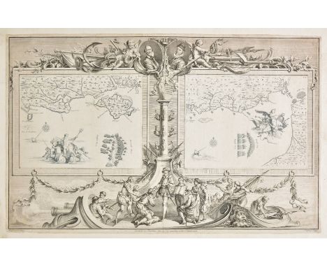
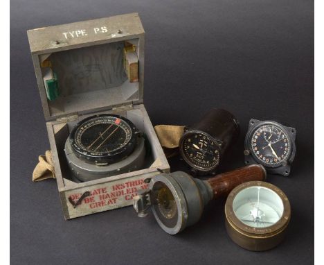
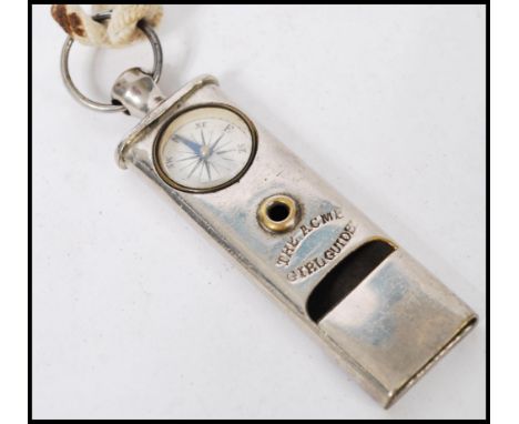
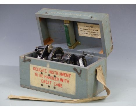
Worcestershire & Warwickshire. Blaeu (Johannes), Wigorniensis comitatus et comitatus Warwicensis nec non Coventrae Libertas. Worcester, Warwik Shire and the Liberty of Coventre, Amsterdam [1658], engraved map with contemporary hand colouring, 410 x 505 mm, Spanish text on verso, mounted, together with Bowen (Emanuel), An accurate map of Worcester divided into hundreds and drawn from the best authorities..., published R. Sayer & Carington Bowles [1779], engraved map with contemporary outline colouring, 535 x 710 mm, together with Bowen (Emanuel), An Accurate map of Worcester divided into its hundreds and drawn from the best authorities..., R. Sayer, C & J Bowles, 1756, engraved map with contemporary outline colouring and some later enhancement, 530 x 705 mm, together with Saxton (Christopher & Hole W.), Wigorniensis comitatus Sabrinae fluminis..., [1637], hand coloured engraved map, large strapwork cartouche, mileage scale and compass rose, 285 x 320 mm, with Van den Keere (Pieter), Worcestershir. circa 1627, hand coloured engraved miniature map, horizontal margins extended, 850 x 125 mm, English text on verso, plus Tunnicliff (William), A new map of Worcestershire..., 1788, engraved map with outline colouring, vertical margins extended, old folds, 470 x 460 mm, with another thirteen maps of Worcestershire, including examples by Conder, Moule, Cary, Lodge, Whittaker, Seller/Grose, Kitchin, Owen & Bowen and Harrison, occasional duplicates, various sizes and condition (19)
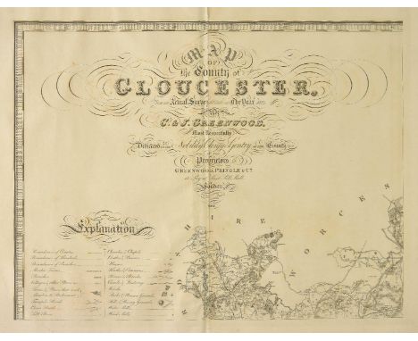
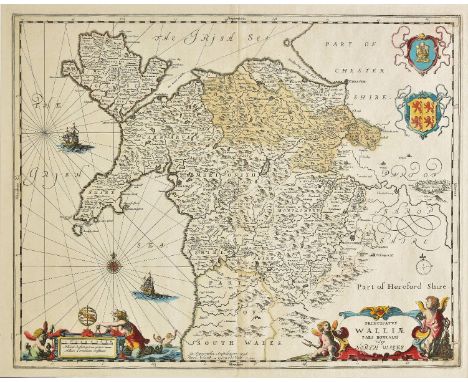
British Canal Map. Walker (John), Map of the Inland Navigation, Canals, and Rail Roads with the Situations of the various Mineral Productions throughout Great Britain, from actual surveys projected on the basis of the trigonometrical Survey made by order of The Honourable The Board of Ordnance..., published Richard Nichols, Wakefield, January 1st, 1830, very large engraved map with contemporary hand colouring, sectionalised and laid on linen, large calligraphic title and dedication, compass rose and table of explanation, inset map of Scotland, slight offsetting, marbled endpapers, 1920 x 1560 mm, contained in a contemporary calf gilt book box, worn at extremities, together with Priestley (Joseph), Historical account of the Navigable Rivers, Canals and Railways throughout Great Britain..., published Logman, Rees, orme, Broan and Green, 1831, title and deication, folding cross section bound at rear, contempoary half calf gilt, heavily worn and rubbed, 4to Published and intended to accompany Joseph Priestley's "Historical Account of the Navigable Rivers, Canals, and Railways, of Great Britain" (includied in the lot). The map contains a wealth of detail bringing together many aspects of the Industrial revolution, namely the mining industry and the canal and railway networks. (2)
A 19th Century brass level by Troughton & Simms with mahogany case and tripod.Condition: compass dial in tact however not in working order, spirit level is empty (brass case only), all moving parts working and moving freely, no major signs of damage or repair, lense has a couple of spots on but otherwise good, focus ok, box contents as pictured, split to top of box as pictured.
A selection of collectors items to include: two black cat stick pins, two small musical boxes, 19 th century papier-mâché snuff box showing a lady in Eastern European peasant costume, a Mauchline ware circular jar cover showing St Mary’s church and schools Ambleside, a Maison Lyons toffee bucket, two decks of playing cards in decorative French case, small oil of a terrier, continental cast pewter chamber stick and owl handle with vester case, selection of maps including railway maps, two pocket watches, white metal purse, military compass, Madam Tussaud & Sons exhibition catalogues 1873, a Brocklehurst Whiston silk of the 1953 coronation etc

-
36562 Los(e)/Seite