36562 Preisdatenbank Los(e) gefunden, die Ihrer Suche entsprechen
36562 Lose gefunden, die zu Ihrer Suche passen. Abonnieren Sie die Preisdatenbank, um sofortigen Zugriff auf alle Dienstleistungen der Preisdatenbank zu haben.
Preisdatenbank abonnieren- Liste
- Galerie
-
36562 Los(e)/Seite


Los 878
Seven Second World War Stars, comprising 1939-45 Star, Atlantic Star, Pacific Star, Africa Star, Italy Star, Burma Star and France and Germany Star, a Defence Medal, a War Medal, a London Fire Brigade bronze medal to `Sydney R. Moody 1950`, a Life Saving Society bronze medal, two school medals, a 1911 Coronation souvenir medal, a red cloth eagle shoulder badge, a quantity of medal ribbons, an Air Council forwarding slip, a pair of Boy Scouts cufflinks, contained in a medals box, two US Army badges and a compass.


Los 69
An unusual desk ornament, in the form of a brass diver’s helmet with compass, brass hour glass (AF) and 2 pen holders, on wooden base; a wooden walking cane with plated metal knob and mounted with WM KRRC badge; a third pattern FS knife; an African short sword with horn hilt; a German WWII metal container for machine gun barrel; and a quantity of German army maps of Drosendorf area (all the same). Average GC
Los 205
8 cap badges: Geo VI RE, WM Tanks, Devon, Suffolk, Westminster, Hereford, Geo VI RASC and RAMC, on a webbing belt; 6 others; a prismatic compass, Mk III, d 1941; a tapered cylinder oil can, d 1917; a “Gallon” measure with handle and spout, khaki painted, with inspector’s stamp; sundry other items. Generally GC


Los 52
A Stainless Steel Automatic Centre Seconds Calendar Wristwatch, circa 2010, lever movement, black dial with luminous baton and Arabic numerals, day/date aperture, case with rotating bezel, crown at 9 to move the inner ring for points of the compass, Seiko steel bracelet with deployant clasp, 47mm wide, with Seiko boxes see illustration


Los 850
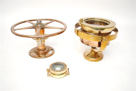
A 19th century rosewood cased set of brass drawing instruments, a similar Victorian mahogany cased set and a quantity of similarly sized boxes containing drawing instruments, two cylindrical slide rules marked Made in England in black painted and chromium plated brass, a simple naturalist`s microscope in oxidised metal, a World War Two Astro Compass Mk II, an early Sinclair Enterprise programmable pocket computer, 1970s, another, etc


Los 287
Astronomical Nautical Compass, c. 1860 Manufactured by: "Lilley & Son, London", brass, lithographed compass rose, graduation 4 x 90°, arc divided 0-150/150-0, circle divided 80-0-80, with embossed brass plaque "By her Majesty`s Royal Letters Patent, E. D. Ashe. R. N., Patentee", height 12 1/2 in. - Probably made for the Royal Society. Astronomisch nautischer Kompaß, um 1860 Hersteller: "Lilley & Son, London", Messing, lithographierte Windrose, Teilung 4 x 90 Grad, Winkelteilungen 0-150/150-0, Kreisteilung, 80-0-80, mit geprägter Plakette "By her Majesty`s Royal Letters Patent, E. D. Ashe. R. N., Patentee", Höhe: 32 cm. Eventuell hergestellt für die Royal Society. Condition: (2-3/3) Starting Price: €500

Los 302
Nuremberg Compass Sundial, c. 1780 Unidentified maker`s mark, brass hour ring, windrose on colored copper plate, in boxwood case with lid, Ø 2 1/4 in. Taschen-Sonnenuhr, Nürnberg, um 1780 Unidentifizierte Meistermarke, in der Art von David Behringer. Messing-Zifferblatt und Polus, feiner kolorierter Windrosen-Kupferstich, in Buchsbaum-Fassung (mit Deckel), Ø 5,8 cm. Condition: (3/2) Starting Price: €160


Los 307
Artillery Compass, End of the 19th Century Germany or Austria, possibly by Voigtländer, lacquered brass, silvered compass scales, size 4 3/4 x 4 3/4 x 4 in. Artillerie-Kompaß, Ende 19. Jh. Deutschland oder Österreich, eventuell Voigtländer, zaponiertes Messing, Skalen im Kompaß versilbert, Maße 12 x 12 x 10 cm. Condition: (2-3/2) Starting Price: €180


![Title Pages ([Leo Belgicus] Verduytscht door Guilliam van Aelst Den. I. Druck), Strada, ca. 1645. 3.5 x 5”. (HC) Among](http://lot-images.atgmedia.com/SR/36385/2862480/2-2012510162021_468x382.jpg)
Los 2
Title Pages ([Leo Belgicus] Verduytscht door Guilliam van Aelst Den. I. Druck), Strada, ca. 1645. 3.5 x 5”. (HC) Among the most interesting decorative works of cartography is a series of arresting maps showing The Netherlands and Belgium in the shape of a lion. This wonderful, miniature version of the Leo Belgicus is based on the original 1538 Aitsinger form with the lion standing facing right with the right paw raised and holding a shield. This version is beautifully engraved with a stippled sea filled with a ship, a sea monster and a compass rose. The De Bello Belgico, written by Famianus Strada, a Jesuit and teacher at the Collegium Romanum in Rome, was a pro-Spanish and pro-Catholic book on the Dutch war of independence. Ref: Tooley (MCC-7) no.21. Backed with tissue to repair small tears, chips and worm holes, several of which just enter image at left and right. Marginal soiling. (B)

Los 13
World (Nova Totius Terrarum Orbis Geographica ac Hydrographica Tabula), Blaeu, Amsterdam, ca. 1635. 21.3 x 16.3”. (HC) A magnificent map featuring a carte-a-figures border with allegorical representations of the sun, the moon, the five known planets, the four elements and the four seasons. Along the bottom are vignettes showing the seven wonders of the world: the Hanging Gardens of Babylon, the Colossus straddling the harbor at Rhodes, the Pyramids, the Mausoleum of Halicarnassus at Cairo, the Temple of Diana, the Statue of Jupiter and the lighthouse at Alexandria. Josua van Ende engraved this map, reducing it from Blaeu`s 1605 wall map for inclusion in atlases. Petrus Plancius` world map of 1592 was the main source of geographical information. The map is shown on Mercator`s projection with a massive Southern Continent attached to New Guinea, with the coastal names of Beach and Psittacorum regio noted from Marco Polo`s travel memoirs. North America has the westward bulge characteristic of the time, with the Strait of Anian noted. Korea is shown as an island and Japan is in a kite-like shape. The map itself is richly decorated with cartouches, sea battles, monsters and compass roses. Fourth state with Tierra del Fuego shown as an island and the date omitted from the lower cartouche on the right. French text on verso. Ref: Goss (Blaeu) no.1; Shirley no.255. Lovely color with slightly uneven toning and two small, insignificant spots in blank areas of map image. (+B)

Los 27
World (An Essay of a New and Compact Map, Containing the Known Parts of the Terrestrial Globe), Bellin, Paris, 1750. 27 x 20”. (HC) Bellin`s popular world map is presented on Mercator`s projection with two fine compass roses orienting the chart. North America is shown with a very pronounced River of the West connecting through a series of rivers and lakes from Lake Superior to the Pacific - representing the elusive Northwest Passage. A portion of the Asian coastline is depicted a short distance from the supposed western coast. The Russian discoveries in the North Pacific are not yet shown, although there is a note about the voyages of 1743. Able Tasman`s new discoveries in New Zealand and Australia are shown. Australia is labeled Hollandia Nova with Nova Guinea linked to the mainland by the Carpentier coastline. Terre de Diemen, also labeled I. Tasman, is connected to the mainland by conjectural dotted lines. A large, decorative title cartouche completes the composition. Published by Peter de Hondt with titles in French and Dutch in lower margin. Issued folding, now pressed with wide margins and slight printer`s ink residue. A few small fold separations, as well as a long tear in upper-right corner, have been professionally repaired. (+B)

Los 44
Ancient World (Geografische Kaarte van de Oude Weereld Volgens de Verdeeling der Kinderen van Noach…), Calmet, Paris, ca. 1725. 17.5 x 12.8”. (HC) This classic map of the ancient world depicts Europe, Asia, and northern Africa with ancient place names. The prominent rococo-style cartouche and a large compass rose with fleur-de-lis adorn the elegant sheet. Watermarked paper with faint toning along centerfold at top. (A)
![Western Hemisphere ([A Correct Sea Chart of the Whole World, According to Wright`s Commonly Called Mercator`s Projection]), H](http://lot-images.atgmedia.com/SR/36385/2862480/72-20125101729_468x382.jpg)
Los 72
Western Hemisphere ([A Correct Sea Chart of the Whole World, According to Wright`s Commonly Called Mercator`s Projection]), Halley, Atlas Maritimus & Commercialis, London, [1728]. 27 x 23.5”. (HC) This sea chart depicts the Western Hemisphere of the four-sheet world map A Correct Sea Chart of the Whole World..., for which the title cartouche resides on the Eastern Hemisphere sheet. The chart depicts the Island of California, with the northwest coast of North America indented before trailing off. The interiors of North and South America are not delineated, with place names focused on the coasts. The Falkland Islands are only partially delineated, and the eastern coast of New Zealand is shown in the south Pacific. Published by J. & J. Knapton and John Senex. The sheet stands well on its own and is decorated with three compass roses. On two sheets, joined. Ref: McLaughlin no.207; Shirley (BL Atlases) no.M.HALL-1a, no.1; Wagner, H. (NW) no.532. Issued folding, now pressed, with light soiling. There is a short fold separation and two 1" tears west of South America that have been professionally repaired. There is a minute hole near the Galapagos Islands, only visible when held to light. (+B)
-
36562 Los(e)/Seite