36562 Preisdatenbank Los(e) gefunden, die Ihrer Suche entsprechen
36562 Lose gefunden, die zu Ihrer Suche passen. Abonnieren Sie die Preisdatenbank, um sofortigen Zugriff auf alle Dienstleistungen der Preisdatenbank zu haben.
Preisdatenbank abonnieren- Liste
- Galerie
-
36562 Los(e)/Seite

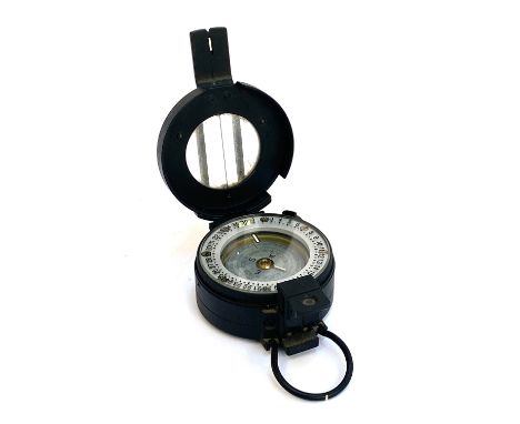
Los 432
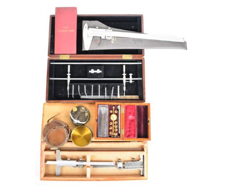
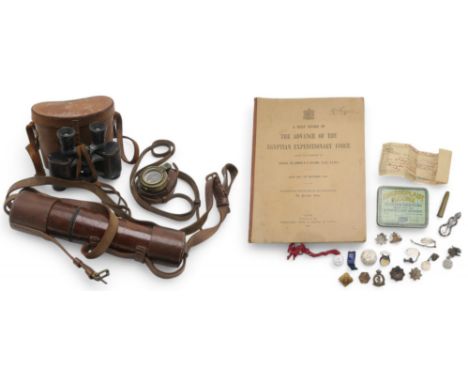
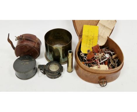
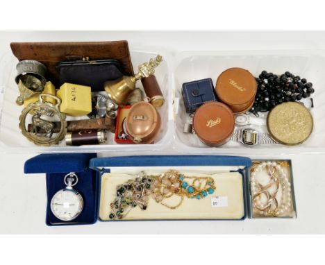
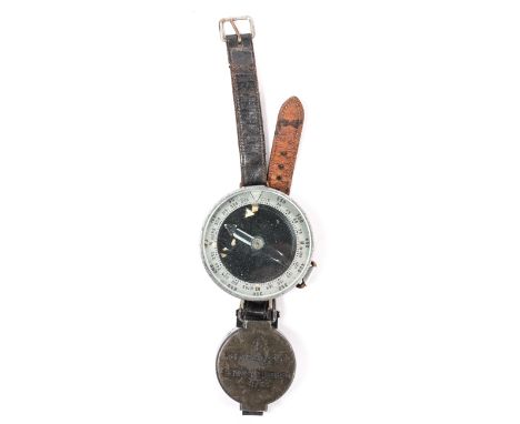
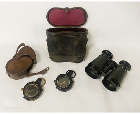
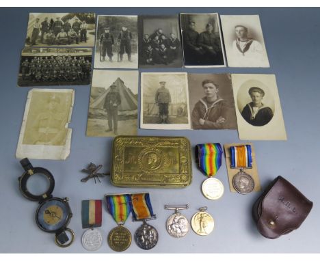
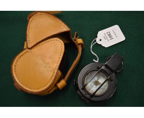
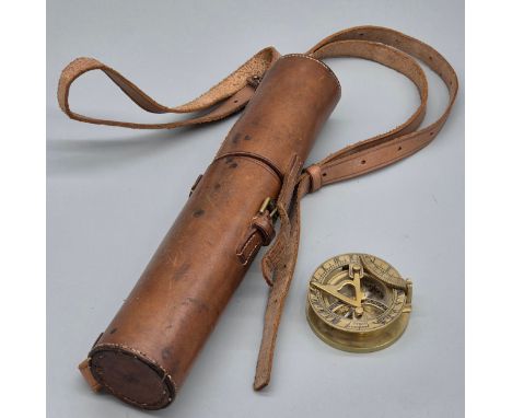
A WW1 1916-dated Tel. Sig. (Mk. IV) military telescope by Negretti & Zambra, London, no. 19193; a 1917-dated Verner's Pattern compass, no. 107488, housed in a leather case stamped "Garston & Co"; a selection of military and other uniform badges; a selection of silver identity tags; and a copy of A Brief Record of the Egyptian Expeditionary Force under the command of General Sir Edmund H.H. Allenby G.C.B., G.C.M.G. July 1917 to October 1918 Condition Report:Available upon request
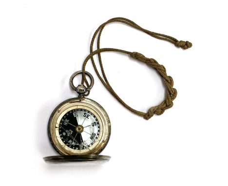
Los 287
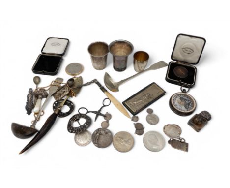
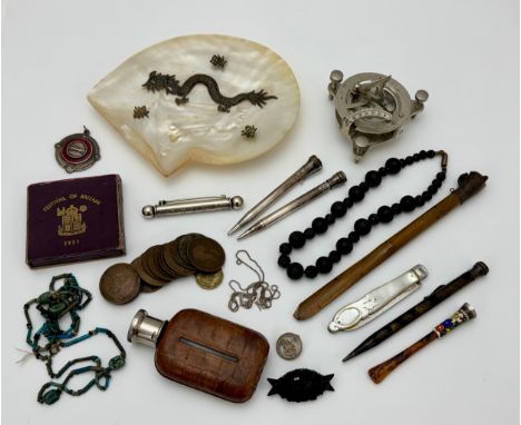
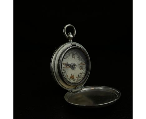
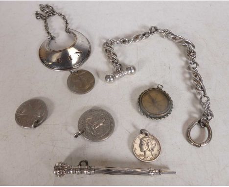
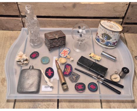
A Norwegian silver shot cup, marked 830S, Torgersen, another marked 830S, inscribed 'Sundre Hotel', a smaller example marked 830S, a mother of pearl-handled baby rattle (af), two fob medals, a silver-topped glass inkwell, a Negretti & Zambra silver-cased mother of pearl compass, a white metal ladle, assorted mounted coins, buckles etc, weighable silver 106gms (qty) Condition Report:Available upon request
Los 107
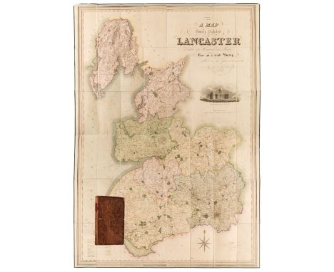
Lancaster. Hennet (George), A Map of the County Palatine of Lancaster Divided into Hundreds and Parishes from an accurate survey made in the years 1828 and 1829, London: Henry Teesdale and Co. May 1st, 1830, engraved map with contemporary hand-colouring, sectionalised and laid on linen with calligraphic cartouche, compass rose, table of explanation and vignette of the New Custom House Liverpool, some offsetting and staining, edged in green silk (some fraying), marbled endpapers, 1600 x 1112 mm, contained in a contemporary calf book box (spine scuffed, corners bumped) QTY: (1)
Los 100
Huntingdonshire. Gordon (William), An Accurate Map of the County of Huntingdon Actually Surveyed after a new Method in the Years 1730 & 1731, large scale map, engraved by Emanuel Bowen, with contemporary outline colouring on six sheets, not conjoined, oval cartouche, compass rose, large allegorical dedication cartouche to William Montague Duke and Earl of Manchester and an inset list of 'Index Villaris', stained and creased and each sheet is heavily frayed and torn with some loss, repaired with tape on verso, each sheet is approximately 490 x 580 mmQTY: (1)NOTE:One of the earliest and rarest large-scale county surveys, but sadly in poor condition. Only two institutional copies found (Cambridge University and the British Library).
Los 90
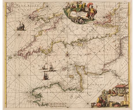
English Channel. Renard (Louis), Canalis inter Angliae et Galliae Littora/Pascaert van't Canaal tusschen Engeland en Vranckryck, Amsterdam, circa 1715-39, engraved sea chart with contemporary outline colouring, two decorative cartouches with titles in Latin and in Dutch, compass rose and numerous rhumb lines, slight repaired marginal fraying but not affecting the printed image, torn with loss to the central fold, skillfully repaired on verso, 480 x 555 mm, together with Van Keulen (Johannes). Nieuwe Pas-Kaert vande Oost Kust van Yrland, Beginnende van de Hoeck van Waterfoort tot aen de Mayds, als mede de West Kust van Engeland van S. David tot Moul van Galoway..., [and] Paskaarte van de Zuyder Zee met Alle des Zelfs Inkoomende Gaaten..., Amsterdam: circa 1681, two engraved sea charts, both with contemporary wash colouring, both oriented to the west, both trimmed with slight loss to the upper horizontal margin, slight dust soiling and staining, each approximately 505 x 580 mm, QTY: (3)
Los 135
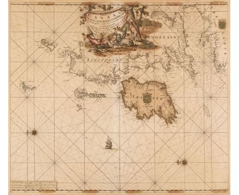
Sea chart. Van Keulen (Johannes), Paskaart van't Canaal Engelandt Schotlandt en Yrland..., Amsterdam: circa 1690, engraved chart of the British Isles and the North Atlantic, orientated to the west, contemporary hand-colouring, decorative cartouche, two compass roses and numerous rhumb lines, some oxidization to the watercolour causing cracking and splitting to the image, strengthened and repaired on the verso, the verso backed with archival tissue, 510 x 580 mmQTY: (1)
Los 32
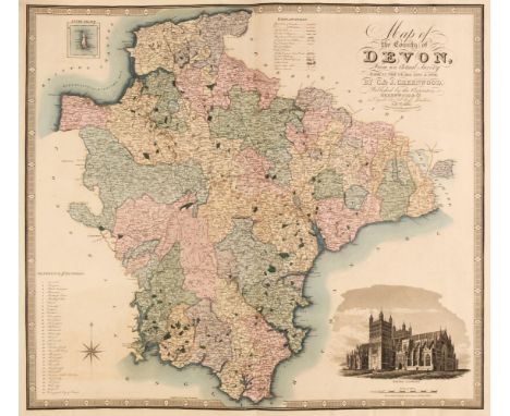
Greenwood (C. & J.). Atlas of the Counties of England from Actual Surveys made from the Years 1817 to 1833..., published 1834, double-page calligraphic title with a hand-coloured map of England & Wales, forty-six (complete) engraved maps with contemporary hand colouring, each with an ecclesiastical vignette, table of explanation, compass rose and calligraphic title, most maps with some offsetting, some spotting throughout, later endpapers, bookplate of Dr D G Bancroft to the front pastedown, later half calf gilt, bumped with wear to the extremities, large folioQTY: (1)NOTE:Chubb CCCCLVIII (b).
Los 165
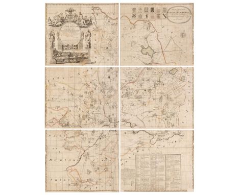
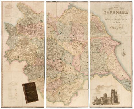
Yorkshire. Teesdale (Henry & Stocking C.), To the Nobility, Gentry & Clergy of Yorkshire, this map of the county constructed from a survey commenced in the year 1817 & corrected in the years 1827 & 1828 is respectfully dedicated by the proprietors, April 21st, 1818, Teesdale & Co. and C. Stocking, April 21, 1828, large scale engraved map with contemporary hand colouring, sectionalised and laid on linen on three sheets, calligraphic title, compass rose, table of explanation and a table of the altitudes of the principal mountains and an uncoloured engraved vignette of the North West View of York Cathedral, some offsetting from the title, some staining and spotting, marbled endpapers, edged in green silk, overall size 1840 x 2230 mm, contained in a contemporary blind-stamped gilt morocco book box, worn, bruised and rubbedQTY: (1)
Los 68
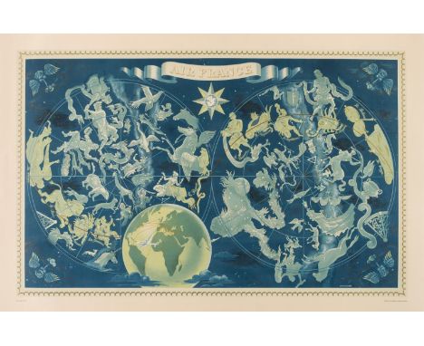
Boucher (Lucien, 1889-1971). Air France, Double-Hemisphere Celestial Map, printed by Perceval, Paris: circa 1950, colour lithographic map of the heavens and the zodiacal constellations, printed in gold, turquoise and blue, wind heads in each corner, small globe to lower centre showing Air France routes around the world and in the upper cusp is a circular image of a hippocampus set within a compass rose, large margins, 620 x 965 mm, laid on later linenQTY: (1)NOTE:The celestial companion piece to Boucher's 1950 double-hemisphere terrestrial map. These large-scale posters proved very popular and were issued in several editions throughout the early 1950s. This example is referenced as "10 - 1950."Louis Boucher designed and produced posters for Air France for nearly thirty years and this clever design manages to give the suggestion of a blend of fantasy and reality, and at the same time provides the viewer with a suggestion of the experience they will have if they choose to fly with Air France. It is designed to capture the imagination and at the same time provides a strong brand message. In an almost surrealistic manner, Boucher has managed to illustrate the constellations as obtainable and encourages us to see the aeroplane as not just the master of the sky, but of the whole universe, connecting the passenger not merely to earthly destinations, but to the stars themselves.
Los 158
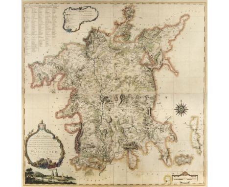
* Worcestershire. Taylor (Isaac), To The Right Honourable Earl of Coventry, Lord Lieutenant & Custos Rotulorum of this County...., This Map of the County of Worcester is most Humbly Dedicated by their Obedient and most Humble Servant, Isaac Taylor, Ross-on-Wye, 1772, large scale engraved map with contemporary outline colouring and some later enhancement, printed on four conjoined sheets, decorative cartouche and mileage scale, compass rose, table of explanation set within a floriate border and a 'list of places taken from the Land Tax book', slight staining, the map appears to have been laid on card, 1030 x 1015 mm, framed and glazedQTY: (1)NOTE:A rare example of one of Isaac Taylor's fine large-scale county maps.
Los 109
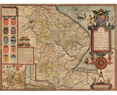
* Lincolnshire. Speed (John), The Countie and Citie of Lyncolne Described, with the Armes of them that have bene Earles thereof since the Conquest, 1st edition, [1611], hand-coloured engraved map, inset town plan of Lincoln, large strapwork cartouche, compass rose and mileage scale, one small rust hole, slight staining, central fold strengthened and repaired on verso, 385 x 505 mm, mounted, framed and double-glazed, English text on versoQTY: (1)
Los 766
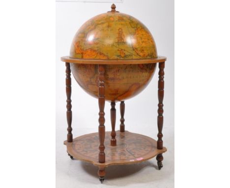
A 20th Century vintage terrestrial mahogany veneer globe drinks cabinet with hinged lid to reveal decanter cocktail cabinet, atop turned supports and castors with finial top. Globe decorated with transfer printed map, wooden piece around the equator depicting illustrations of zodiac signs, and compass points decorating the lower tier. Measures approx: 94x54cm
Los 201
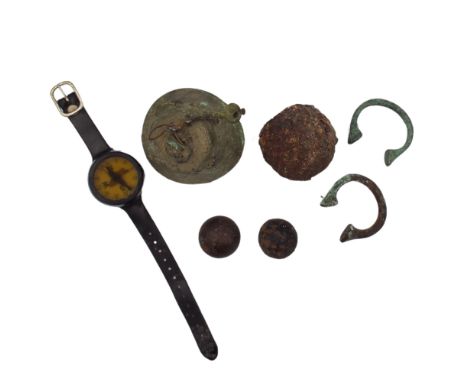
Wreck Salvage, Roland Morris collection. Various salvage to include three various sized round shot, two manilla bangles, a small bell, two wreck coins, a divers wrist depth gauge and a divers wrist compass. Condition report all with verdigris or concretions. Roland Morris was a well known maritime archeologist, historian, writer and entrepreneur based in Cornwall, particularly Penzance. His most famous discovery was the wreck of the Association also working on other major wrecks around the Cornish coast. He also opened the Admiral Benbow a much celebrated pub filled with nautical themed decoration.
Los 300
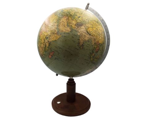
A circa 1920 12" world globe map. Roland Morris collection. Raised on a turned base with inset compass, height 53cm. Roland Morris was a well known maritime archeologist, historian, writer and entrepreneur based in Cornwall, particularly Penzance. His most famous discovery was the wreck of the Association also working on other major wrecks around the Cornish coast. He also opened the Admiral Benbow a much celebrated pub filled with nautical themed decoration.
Los 206
Assorted collectables including silver plated sifter, a Halcyon Days pill box, collection of antique keys, Japanese black lacquered cylindrical pot and cover, assorted early to mid-20th century British coinage, a Chinese carved soapstone spherical pot and cover, a bakelite cased trough compass, three letters dated 1846-47 bearing franked red penny stamps and other items
Los 747
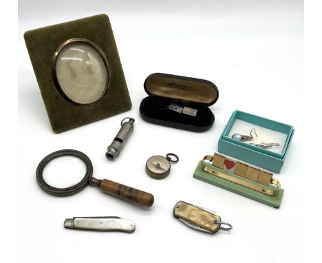
A tortoiseshell bamboo-shaped parasol handle and tip, late 19th c, 41cm l, a Victorian white metal miles from London medallion by I Ottley, medallist, Birmingham, 50mm diam, a nickel-plated watch-shaped Moko Lightning Calculator, c1900, a plated watch fob compass in the form a Sovereign case, etc Parasol handle in good condition, save for slight graze on one of the nodules Medallion with slight corrosion Lightning calculator - wear to plating All in good or very good overall condition
Los 891
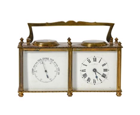
A brass cased carriage clock compendium, with barometer and compass, early 20th c, with shaped brass handle, and six turned feet, two white enamel panels with black lettering and numerals. Worn makers mark, two circular glasses to the top, to a dial compass and the balance wheel and adjuster, with key. In a fitted brown leather, red lined travel case with twin doors. 8cm h, case 12cm h Clock, overall condition appears to be appropriate for age, with some discolouration to brass. Working order not checked. Case, damage to top hinge on right hand side, absence of handle, wear is consistent with age and use.
Los 524
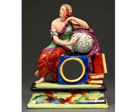
A Staffordshire pearlware watch stand modelled with a classical woman as the Goddess of Truth or Urania, the muse of Astronomy, c1820, seated upon a plinth and gesturing with a compass towards a globe, 23.5cm h Restoration and chips to interior of watch aperture, very minor chips to edges of book, some very minor flaking to glaze

Los 776
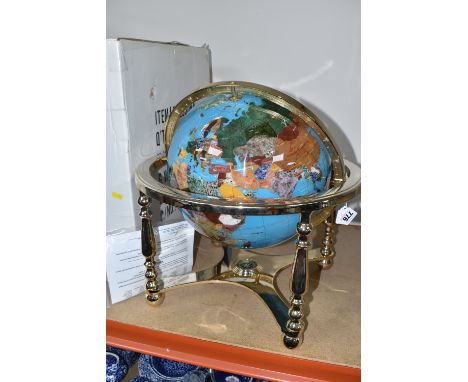
A BOXED GLOBE 'GEMSTONE GLOBE' IN A ROTATING CRADLE with a compass fitted to the lower part of the gilt metal cradle, countries represented in various precious stones to include jadeite stones, jasper, mother of pearl, unakite etc., height approximately 38cm x diameter approximately 40cm, with original tag attached to the central band, letter of authenticity included (1 + box) (Condition Report: appears in good condition, some knocks to the box)
Los 1493
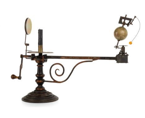
the signed rotating globe above a metal geared movement on the end of a turned arm with scroll support to the papered Zodiac disc showing compass directions, days of the Zodiac with pictures, candle holder to centre with polished reflector, fruitwood turning handle raised on a cast-iron column and stepped base with beaded border Note: J.L. & Cie was founded in 1814 by Alphonse Lebeque in Brussels, as a maker of globes. Since circa 1850 as J. Lebegue & Cie based in Paris 58cm long
-
36562 Los(e)/Seite