36562 Preisdatenbank Los(e) gefunden, die Ihrer Suche entsprechen
36562 Lose gefunden, die zu Ihrer Suche passen. Abonnieren Sie die Preisdatenbank, um sofortigen Zugriff auf alle Dienstleistungen der Preisdatenbank zu haben.
Preisdatenbank abonnieren- Liste
- Galerie
-
36562 Los(e)/Seite


Los 1
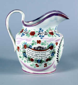
A LARGE GEORGE IV SUNDERLAND LUSTRE POTTERY MARRIAGE JUG, the shouldered ovoid body with strap handle and a broad spout, painted with an oval cartouche inscribed "John & Jane Tilton 1827", flanked by overpainted sepia prints, one with verse "Forget not Christ the Lord of hosts....." within flowers and a sailing ship, the other with an archway with open curtains revealing the all-seeing eye, the seven steps entitled with the seven Liberal Arts above some of their attributes (most prominently the Masonic emblems of crossed square and compass), beside Christ holding the cross and Bible, 21cm, (8.3in) high

Los 1
A 9CT YELLOW METAL-MOUNTED SHELL CAMEO, the oval field, of pale pink ("angel-skin") hue, carved with a Classical-style warrior with plumed helmet, armoured tunic and circular shield, within plain and rope-twist surround with bead-and-scroll mounts and the four compass points, marked 9CT verso, with safety chain and pin fastening, 5.3cm, (2.1in) high


Los 1
A French brass-cased combination desk timepiece, the left section of the rectangular case with a single train movement with lever escapement, the gilt dial with a silvered chapter ring and Roman numerals, inscribed with retailer's name CONNARD SOUTHPORT, the right section of the case with a barometer with silvered round register and central sweep hand, a therometer between the two dials, the case surmounted with an escapement view, a compass and carrying handle, 16.5cm wide (one glass cracked)


Los 1
A Sunderland pink lustreware jug, transfer printed in black with a Mariners compass and inscription, 'The hardy sailor...' and two lusterware beakers, 2.5ins, one decorated with cattle, the other a ruin, both with inscription, 'Health love and ready...' and a small Doulton rectangular vase with hibiscus pattern and mark to base, 5.5ins 4.5ins


Los 1
A Group of Five Second World War Medals, awarded to 4389046 WO Class II W Richardson Green Howards, comprising 1939/45 and Africa stars, Defence Medal, War Medal and Territorial Efficiency Medal; together with a prismatic compass, badges and flashes, gaiters, gloves and forage caps all contained in a suitcase.
Los 1
Channel Islands. Speed (John), Holy Island, Garnsey, Farne & Jarsey, sold Bassett & Chisswell, [1676], uncoloured engraved map of Geurnsey, Jersey, Farne and Holy Island, each with a separate title cartouche and compass rose, paper repair to lower margin of central fold, approx. 380 x 510 mm (1).
![Channel Islands. Speed (John), Holy Iland, Garnsey, Farne, Jarsey, sold Sudbury & Humble, 1610 [but later], hand coloured e](http://lot-images.atgmedia.com/SR/10729/1946898/354-2-10729_468x382.jpg)
Los 1
Channel Islands. Speed (John), Holy Iland, Garnsey, Farne, Jarsey, sold Sudbury & Humble, 1610 [but later], hand coloured engraved maps showing Jersey, Guernsey, Farne and Holy Island, compass roses and rhumb lines, paper repair to verso of central fold, approx. 380 x 510 mm, framed and glazed. (1).
Los 1
Dorset. Duncan (J., pub.), Map of the County of Dorsetshire; divided into Hundreds, Containing the District Divisions and other Local Arrangements effected by the Reform Bill, c.1830s, hand coloured engraved map with calligraphic title and compass rose, some light spotting, approx. 350 x 430 mm, framed and glazed (1).
![Isle of Man. Speed (John), The Isle of Man exactly described, 1610 [but later], hand coloured engraved map, central compass](http://lot-images.atgmedia.com/SR/10729/1946898/394-2-10729_468x382.jpg)
Los 1
Atlantic. Carte des Declinaisons et Inclinaisons de l'Aiguille Aimantee redigee d'apres la table des Observations Magnetiques faites par les Voyageurs depuis l'Annee 1775, uncoloured engraved chart showing most of Europe, West Africa and part of the Eastern coast of America, with numerous compass bearings shown, some offsetting, approx. 460 x 540 mm (1).

Los 1
South America. Mercator (Gerard), Venezuela, cum parte Australi Novae Andalusiae, Amsterdam: Henricus Hondius, c.1640, engraved map, hand coloured in outline, ornamental title cartouche, two compass roses and rhumb lines, light browning to margins, one 2 mm diameter hole, approx. 380 x 500 mm, French text to verso (1).
Los 1
World. Arrowsmith (Aaron), The World from the Discoveries & Observations made in the Latest Voyages & Travels, c.1800, hand coloured engraved twin-hemisphere map, approx. 250 x 450 mm, not laid down, together with Bowen (Thomas), A New & Accurate Chart of the Western or Atlantic Ocean, 1778, engraved map, hand coloured in outline with compass rose and rhumb lines, approx. 215 x 270 mm, not laid down, both framed and glazed (2).


![Holy Land. Speed (John), Canaan ... [1676], uncol. eng. map, ornamental strapwork title cartouche flanked by historical figu](http://lot-images.atgmedia.com/SR/10729/1877960/314-1-10729_468x382.jpg)
Los 1
Holy Land. Speed (John), Canaan ... [1676], uncol. eng. map, ornamental strapwork title cartouche flanked by historical figures, separate scale of distance, inset plan of Jerusalem, ornamental strapwork cartouche containing a description of Canaan, compass rose, sailing ship, sea monsters, etc., English text to verso, approx. 39 x 52 cm. (1)
Los 1
*Yorkshire. Duncan (J., pub.), Map of the County of Yorkshire divided into its Ridings with their Sub-Divisions containing the District Divisions and other Local Arrangements effected by the Reform Bill, c.1840, hand coloured engraved map with calligraphic title and compass rose, approx. 440 x 670 mm, framed and glazed (1)
Los 1
Dorset & Kent. Collins (Captain Greenvile), A Draught of Portland the Shambles and the Race of Portland, [1779], hand coloured engraved chart with rhumb lines and compass rose, approx. 430 x 600 mm, together with a similar (but smaller) engraved chart of the mouth of the river Rother showing Rye, approx. 450 x 290 mm (2)

Los 1
FAIRBURN, JOHN, publisher. Fairburn's Travelling Handkerchief. A Map of England and Wales, exhibiting the Roads, Cities, Towns and Principal Villages, with their Bearing by Compass ans Distance from London, 1831 Engraved by E.Bourne. Engraved map, printed on silk with vignette in top right hand corner. Framed and glazed. 563 x 460 mm. (some worming and a brown mark in Cornwall).

-
36562 Los(e)/Seite