

North America (Mondo Nuovo), Porcacchi, L`Isole piu Famose del Mondo, Venice, ca. 1576. 5.6 x 4”. (HC) First state of this charming copper engraved map of the continent based on the Paolo Forlani map. The continent depicts the vastly elongated extension of the eastern seaboard, the Strait of Anian, a rather odd bulge in the California peninsula and Giapan (Japan) just offshore. The map has a stippled engraved sea in the Italian style and is decorated with a strapwork title cartouche, compass rose and two wild-looking sea creatures. On a full sheet of Italian text. Ref: Burden no.42; Manasek no.35. There are a few spots and an archivally repaired tear that enters 0.25" into map image at left . The sheet of text has a few damp stains that do not impact map image. (+B)
36562 Preisdatenbank Los(e) gefunden, die Ihrer Suche entsprechen
36562 Lose gefunden, die zu Ihrer Suche passen. Abonnieren Sie die Preisdatenbank, um sofortigen Zugriff auf alle Dienstleistungen der Preisdatenbank zu haben.
Preisdatenbank abonnieren- Liste
- Galerie
-
36562 Los(e)/Seite

Eastern North America (Map of the European Settlements in North America), Kitchin, A Philosophical and Political History…, London, ca. 1779. 9.5 x 12.5”. (HC) This map covers the eastern part of North America from Greenland to Florida with settlement confined to the eastern seaboard. Numerous Indian names are noted throughout. A comment by L. Ouinipigon alludes to a Northwest Passage: "R. of ye Assenpouels supposed to fall into the Western Ocean." The map is adorned with a garland style title cartouche and compass rose. This map appeared in both the 1779 and 1784 editions of Abbe Raynal`s A Philosophical and Political History of the Settlements and Trade of the Europeans in the East and West Indies. Ref: McCorkle no.779.9. Issued folding, now pressed with light offsetting. There is a binding trim at right, but still ample room for framing. (+B)

Newfoundland, Canada (A New and Correct Chart of the Coast of New Foundland from Cape Raze to Cape Bonavista…), Mount & Page, The English Pilot: The Fourth Book, London, ca. 1753. 40 x 16.8”. (HC) Large, handsome chart of the Avalon Peninsula with an inset showing one of the earliest plans of Halifax. Two additional insets, with fancy rococo-style borders, detail Trinity Harbour and St. John`s Harbour. Bold and well-engraved chart ornamented with three large compass roses orienting north to the right. Two sheets joined as issued. Ref: Kershaw no.523; Shirley (BL Atlases) M.M&P-5d no.7. Good impression with a close margin at left with some paper laid in and a little facsimile on neatline. There are a couple of short tears across centerfold. (+C)

Colonial New England and Mid-Atlantic (Nova Anglia Novum Belgium et Virginia), Jansson, Atlas or a Geographicke description of the Regions…, Amsterdam, [1636]. 20 x 15.3”. (HC) This is the first state of Jansson`s important map of the eastern coast of North America covering from just south of the outer banks in present-day North Carolina to Nova Scotia. The map is based on the less well-known map of Johannes de Laet of 1630, but covers a slightly larger area. Because of its wider distribution, Jansson`s map was much more influential, particularly with its depiction of the Dutch of Nieuw Nederland (New York). Cape Cod, Lake Champlain, Long Island, and the Chesapeake Bay are easily recognized compared to earlier maps. In fact, this map contains some of the earliest accurate cartography of the region showing New Amsterdam, Manhattan Island (Manbattes), Fort Orange, the Hudson (Noordt River) and the Delaware (Zuydt River). The map includes part of the Great Lakes, labeled Grand Lac and Lac des Yroquois, an unnamed Lake Champlain, and a fictitious lake at the headwaters of the Delaware River. According to Karpinski, this "is the first printed complete map of Lake Superior" although according to Burden there is no evidence to support that and Grand Lac is more likely Lake Huron. The map is adorned with two decorative cartouches, ships, sea monsters and compass roses. A portion of the entertaining English narrative on the verso describes the edible denizens of the sea in verse: The Luscious Lobster, with the Crabfish raw. The Brinish Oyster, Muscle Periwigge And Tortoise Sought for by the Indian Squaw Which to the flats dance many a winters Jigge, To dive for Cocles, and to digge for Clammes, Whereby her Lazie Husbands guttes she crammes. Ref: Burden no.247; Cumming (SE) no.39; Karpinski, p. 26 & 31 plt. II; McCorkle no.636.2. The map has been professionally cleaned with a 1" tear to the left of the title cartouche and centerfold separations at top and bottom extending 2" and 0.5" into the image respectively, all of which have been almost invisibly repaired. A number of chips and tears in the blank margins have also been expertly repaired. The original color is a bit faded and there is a minute hole in the title cartouche. (B)

Colonial Mid-Atlantic (A Map of the Country round Philadelphia Including Part of New Jersey New York Staten Island & Long Island), Anon., Gentleman`s Magazine, Edinburgh, [1776]. 8.5 x 7”. (BW) This Revolutionary Warperiod map encompasses the area of Eastern Pennsylvania through Long Island and south to include Chesapeake Bay. The map was issued to illustrate the British Army`s objective of defeating Gen. Washington at Long Island and then to march to Philadelphia and put a quick end to the conflict. It is centered on Philadelphia, includes most of New Jersey, Delaware, Long Island, southwest Pennsylvania, northern Chesapeake Bay and the greater New York City area. The southern New Jersey coast is labeled Sandy Barren Deserts. The map is filled with interesting features including Indian villages, towns and cities, ferries, and roads (including the distances between towns). Adorned with a simple compass rose. Ref: Jolly GENT-247; Phillips (M) p.699; Klein G76.6; Sellers and Van Ee 1041. Issued folding, with light offsetting and a few short fold separations in blank margins, closed on verso with archival tape. (+B)

Mid-Atlantic United States (A Map of Pennsylvania Delaware New Jersey & Maryland, with the Parts Adjacent), Thackara, The History of Pennsylvania, Boston, [1798]. 15.3 x 12.3”. (BW) This rare map was engraved by James Thackara and published in Robert Proud`s The History of Pennsylvania. The map covers an area from southern New York to Central Virginia and displays rudimentary topographical detail of the Allegheny Mountains and Chesapeake Bay as well as towns, settlements, roads and rivers. Delaware is also labeled as Territories of Pennsylvania. A simple compass rose adorns the Atlantic Ocean. Ref: Wheat & Brun no.312. Issued folding with a few tiny fold separations that have been closed with archival tape on verso, a very small wormhole at lower right and some scattered spots in the image. There is a binding trim and minor insertion tear at lower right that has been repaired with old paper. (B)

Gulf of Mexico and Caribbean (Insulae Americanae in Oceano Septentrionali, cum Terris Adiacentibus), Montanus, De Nieuwe en Onbekende Weereld…, Amsterdam, [1671]. 14.2 x 11.2”. (HC) This is the first state of this outstanding map of the West Indies that also incorporates the eastern coast of North America from the Chesapeake Bay through the Gulf of Mexico, Central America and the northern coast of South America. The cartography is based on Hessel Gerritsz` chart of 1631 and Blaeu`s map of 1634. The scenic title cartouche fills the North American continent and an equally graphic scale of miles cartouche fills the interior of South America, each surrounded by Native Americans and European merchants. The seas are embellished with rhumb lines, ships and compass roses. Ref: Burden no.414. There is a hint of toning along the centerfold and remnants of hinge tape on verso. (A)
![Cuba ([Lot of 2] A New Chart of the Seas, Surrounding the Island of Cuba… [and] A Plan of the City and Harbour of Havan](http://lot-images.atgmedia.com/SR/36385/2862480/358-2012510163135_468x382.jpg)
Cuba ([Lot of 2] A New Chart of the Seas, Surrounding the Island of Cuba… [and] A Plan of the City and Harbour of Havanna, Capital of the Island of Cuba), London Magazine, London, [1762]. x ”. A. A New Chart of the Seas, Surrounding the Island of Cuba..., by Thomas Kitchin, hand color (14.5 x 10.5"). This attractive chart displays the tracks of galleons from Carthagena to Havana and the track of the "Galleons home" off the Florida coast. The depiction of southern Florida with many inland waterways was typical of the time. Includes the inset a "Plan of the Harbour and Town of Havana, Taken on the Spot by an Officer of the Navy." Decorated with a rococo-style title cartouche and large compass rose with rhumb lines. Published in the October 1762 issue. Condition: Issued folding on watermarked paper with a few tiny fold separations that have been partially closed on verso. There is a binding trim at left that has been repaired with old paper and a resulting tear that enters 1" into image that has been archivally repaired, as well as an archivally repaired tear that enters 0.5" at bottom. B. A Plan of the City and Harbour of Havanna, Capital of the Island of Cuba, black & white (4.5" x 7"). Map shows the harbor and town with the surrounding area. Legend keyed to map gives location of 19 important places and a castle. From the May 1762 issue. Condition: There is a miniscule hole in the lower right neatline, only visible when held to light and some faint toning. Ref: Jolly LOND-217 & LOND-213. See descriptions. (+B)

Lesser Antilles (Canibales Insulae), Blaeu, Atlas Maior sive Geographia, Amsterdam, ca. 1662. 21 x 16.5”. (HC) This is the first Dutch map to focus on the Lesser Antilles. It covers the Windward and Leeward Isles from Puerto Rico to Trinidad and Margarita. Centered on a compass rose with north at right, the chart is less decorative than other maps by Blaeu, having instead a practical navigational chart appearance. The title - Islands of the Cannibals - is certainly evocative. It illustrates the European impression of the mysterious islands of the New World resulting from many explorers` accounts of the savage Caribbean warriors who devoured their prisoners. Blaeu`s map appeared only in editions of the great Atlas Maior from 1662, thus it is relatively uncommon. Latin text on verso. Ref: Goss (Blaeu) p. 162. Lightly toned, watermarked paper with a few faint spots and light show-through of text on verso. There is some scattered foxing primarily in the blank margins and a small hole in right blank margin, not affecting map image. (B)

Barbados (Insula Barbadoes in suas Parochias Distincta, una cum Oris Maritimis, Viis &c. ad Fidem Anglicani Authoris Delineata), Homann Heirs, Nuremberg, ca. 1737. 11 x 13.3”. (HC) This bold copper-engraved map of Barbados was copied from Moll`s map of 1729. The island is divided into parishes, with numerous cities, churches, plantations, and roads depicted. A decorative compass rose orients west at the top of the map. Contained in the title cartouche are a legend, a list of the eleven parishes with their population, and a note giving a brief history of Barbados from the reign of King James I. The Barbados map was one of five maps on the sheet, including St. Kitts, Antigua, Bermuda, and Jamaica, which have been trimmed from this folio sheet. Above the map is an elaborate title cartouche for the whole sheet in both Latin and German, decorated with coconut trees and local flowers. Ref: Campbell, Tony (MCC-21) no.26. Light soiling, a few creases, and a minute tear in title cartouche that has been archivally repaired. Trimmed to neatlines at left and bottom and remargined. (+B)

Lesser Antilles - St. Kitts, Guadalupe, Martinique (A New Mapp of the Island of St. Christophers being an Actuall Survey Taken by Mr. Andrew Norwood), Mount & Page, The English Pilot, London, ca. 1770. 21 x 17”. (HC) This is an excellent map of St. Christophers, now known as St. Kitts, showing the parishes, forts, settlements, and churches. The map is beautifully composed with two other maps on the same sheet. They are inset into the main map with a vine border and each has its own cartouche and compass rose; A New Mapp of the Island of Guadalupa, and A New Mapp of the Island of Martineca. Ref: Shirley (BL Atlases) M.M&P-5h no.15.1-3. Light toning and offsetting with some printer`s ink residue. There are some small tears and chips in blank margins that have been archivally repaired, one of which just enters neatline at top. (+B)
![Colombia, Venezuela, Panama, Costa Rica & Ecuador ([Lot of 2] Colombia [and] Carte des Pays Situes sur la Mer du Sud Depu](http://lot-images.atgmedia.com/SR/36385/2862480/379-2012510163317_468x382.jpg)
Colombia, Venezuela, Panama, Costa Rica & Ecuador ([Lot of 2] Colombia [and] Carte des Pays Situes sur la Mer du Sud Depuis Panama jusqu`a Guayaquil…), London, ca. 1779-1828. x ”. (HC) A) Colombia, by Sidney Hall, from A New General Atlas, published 1828, hand color (20.3 x 16.5"). This detailed map of Colombia includes Costa Rica, Panama, Venezuela, Ecuador and part of Brazil. It identifies key regions, towns, rivers and depicts mountains via hachure. The map is surrounded by a lovely keyboard style border. Ref: Kapp (Colombia) no.143. Condition: Wide margins with faint, scattered foxing. There is cello tape residue in upper blank margin, and a short tear in left blank margin far from map image. (B+) B) Carte des Pays Situes sur la Mer Du Sud Depuis Panama jusqu`a Guayaquil..., by William Robertson, from Histoire de l`Amerique, circa 1779, black & white (9.5 x 14.5"). This map stretches from Costa Rica to Colombia, to the tip of Peru in the south, and depicts the towns, rivers and a few roads. The map is adorned by a decorative floral title cartouche and a simple compass rose. Engraved by Benard. Condition: Folding, as issued, with a binding trim at left. There is light offsetting and two faint spots - one in blank area of map image at left and the second just entering map border at bottom. (B+) See description. ()

Guyana (Pas-Kaart van de Zee-Kusten van Guiana tusschen Cabo Noord en Rio Amano…), Keulen, Amsterdam, ca. 1700. 23.3 x 20.5”. (BW) Scarce sea chart centering on the bay at what is now Georgetown in Guyana, with an inset of the mouth of the Essequibo River and a plan of Fort Cajana. The map is detailed with soundings, currents, shoals and anchorages and embellished with rhumb lines, a sailing ship and compass roses oriented with north to the right. The striking title cartouche features two natives with their tame leopards. A dark impression with light offsetting and a few small abrasions and a tiny tear in the upper right blank margin. (+B)

Brazil (Pas-kaart, Van de Zee-Kusten van, Brazilia, Tusschen, C.S. Thome en I.S. Catharina…), Keulen, Amsterdam, ca. 1682. 23 x 20”. (HC) Rare sea chart of the Brazilian coast from Illia S. Catharina to Cabo S. Thome, along with an inset of Rio Ianeiro (Rio de Janeiro and Guanabara Bay). The decorative chart is filled with rhumb lines, two compass roses, and a sailing ship. The title cartouche is flanked by natives trading goods with a European merchant, and a tent in the background. A fine impression with attractive color. There are a few faint spots and a couple of tiny holes that have been archivally repaired. There are a few tiny tears, a small damp stain at top, and some archivally repaired chips, all confined to blank margins. (+B)

Brazil (Pas-Kaart van de Zee-Kusten van Brazilia, tusschen Bahia Baxa en Punto de Lucena…), Keulen, Amsterdam, ca. 1683. 22.5 x 19.8”. (HC) Sea chart of the Brazilian coast from Punto de Lucena to Bahia Baxa, along with an inset of Rio Grando to Punto de Lucena. The decorative chart is filled with rhumb lines, two compass roses with north to the bottom, and a sailing ship. The title cartouche is flanked by two natives, and a large distance scale cartouche depicts natives cutting a log. A nice impression with light soiling. There are some professional repairs to a few tiny holes, a 3/4" tear at top right, and a few short separations and tears along centerfold, with a minor amount of rhumb lines in facsimile at bottom center. Backed with tissue. (+B)

Brazil (Accuratissima Brasiliae Tabula), Hondius/Schenk & Valck, Amsterdam, ca. 1708. 19 x 14.8”. (HC) Magnificent depiction of Brazil with north oriented to the right by a handsome compass rose. The map is inset with two regions of Dutch interest in the area: Baja de Todos los Sanctos and Pernambuco. The interior is bereft of geographical information except for largely imaginary rivers and forests. Instead the region is filled with dramatic scenes of the indigenous people, including warfare and cannibalism, and some curious wildlife. The hereditary captaincies established by the Portuguese are noted along the coastline. The decorative title cartouche is flanked by a native family and the seas are adorned with sailing ships, a sea monster and a compass rose. Wide margins with a few minor spots of foxing and light stains. (+B)

Brazil (Littora Brasiliae / Pascaert van Brasil), Renard/De Wit, Amsterdam, ca. 1715. 22.3 x 19”. (HC) This magnificent map of Brazil is primarily a sea chart with details confined to the coastline. Oriented with north to the left by two fine compass roses, it covers the Brazilian coastline from the mouth of the Amazon to the Rio de la Plata in what is now Argentina. A dramatic title cartouche that fills the interior is constructed of a montage of scenes showing Portuguese and Dutch explorers and missionaries, an Indian ceremony, mining, exotic animals and produce, etc. Rhumb lines cross the entire map, which is further embellished by four sailing ships. North is oriented to the left. This is the Renard edition of the map that was first published by Frederick de Wit, circa 1675. There is some minor soiling and small worm holes and tracks that have been professionally infilled near the centerfold, with a small amount of image in facsimile and a few tiny areas of loss of image. (+B)

Eastern Brazil (Capitaniae de Cirii, et Parnambuco), Jansson, Atlas Novus, Amsterdam, ca. 1657. 21.5 x 17.5”. (HC) This rare chart of the Captaincies of Ceara and Pernambuco extends from the Rio Formosa to the Rio Estremo and is centered on the Rio de San Francisco. Much information is derived from maps drawn for the Dutch West Indies Company during its bid to rest control of the region from the Portuguese. North is oriented to the right of the chart by a compass rose. It is finely adorned with two cartouches and sailing ships. Lovely original color with light offsetting, two 1/2" centerfold separations towards the top, and a couple of minute cracks caused by the oxidation of the green pigment. There is a tear that just enters map border at bottom that has been closed with archival materials. (+B)

Central South America, Paraguay (Paraguay, o Prov. de Rio de la Plata cum Regionibus Adiacentibus Tucuman et Sta. Cruz de la Sierra), Blaeu, Amsterdam, ca. 1640. 19 x 14.8”. (HC) Superb map of the region including the Paraguay River basin and the Peru-Chilean coast with Lake Titicaca. The Rio de la Plata is boldly shown with many large islands in the broad river. The mythical Lago de los Xarayes is featured on the map, which was believed to connect the Rio de la Plata and Amazon River systems. Several towns are named including R. Ianeiro, S. Paulo, Buenos Ayres, Corduba, Medoca, Arica, Potosi and Cusco. A large decorative title cartouche incorporates the distance scales, while a smaller cartouche features an armillary sphere. A fine, large compass rose with fleur-de-lys also adorns the sheet. Dutch text on verso. Old color and wide margins with light damp stains that just enter map border at bottom & a couple tiny tears in wide original margins, none affecting the map. (+B)

Peru (Peru), Gerritsz/De Laet, ca. 1633. 14 x 11”. (HC) This great map is a foundation map for later Dutch maps of Peru. The map is the work of Hessel Gerritsz, one of the truly important Dutch cartographers of the 17th century. Most of his work was only done in manuscript and these maps, published by De Laet, are the only Gerritsz maps available to the collector today. The map vividly depicts the mountainous region and the large Titicaca lake, which is dotted with islands. A splendid strapwork title cartouche and compass rose adorn the map. Watermarked paper with light surface soil and a crease along right side, now pressed. There are two minute worm holes only visible when held to bright light. Remargined at bottom and expert repairs of a couple tiny marginal tears. (+B)

Chile (Chili), Gerritsz/De Laet, ca. 1630. 14 x 11”. (BW) This bold map covers Chili, from Puente de Vetes in the North to Cap de Diego Gallego in the south with north to the left. Beautiful title cartouche, scale of miles, map key and a large compass rose make this a very attractive sheet. Hessel Gerritsz`s cartography of South America laid the foundation for many other cartographers. Johannes de Laet, the director of the Dutch West India Company, was privy to the latest topographical knowledge. There are a few worm tracks and wormholes in the lower blank margin and the sheet is lightly toned. (+B)
![Southern South America (Fretum Magellanicum, und dessen Eigentliche Beschreibung…), Bry, Grand Voyages Part IX, [1601].](http://lot-images.atgmedia.com/SR/36385/2862480/407-2012510163535_468x382.jpg)
Southern South America (Fretum Magellanicum, und dessen Eigentliche Beschreibung…), Bry, Grand Voyages Part IX, [1601]. 11.8 x 6.5”. (BW) This small copper engraved map illustrates the voyages of Sebald de Weert and Olivier van Noordt through the Straits of Magellen in 1598. It features renderings of the native inhabitants taken from the illustrations to De Weert’s voyage and an interesting depiction of a penguin and a giant snail. The map is further adorned with a compass rose orienting the map with south at the top, and two strapwork cartouches. Ref: Garratt [TMC-9] pp. 2-11, no.G13. Wide margins with just a hint of toning. (A)
![Southern South America ([Lot of 2] Plan de la Ville de Buenos-Ayres [and] Argentine Republic, Chili, Uruguay & Paraguay),](http://lot-images.atgmedia.com/SR/36385/2862480/410-2012510163554_468x382.jpg)
Southern South America ([Lot of 2] Plan de la Ville de Buenos-Ayres [and] Argentine Republic, Chili, Uruguay & Paraguay), Paris, ca. 1757-1855. x ”. A. Plan de la Ville de Buenos-Ayres, by Jacques Bellin, from Histoire Generale des Voyages, circa 1757, black & white (10.8 x 7.0"). This early plan of Buenos Aires is laid out in blocks with unnamed streets. A few important buildings are identified and the fort is prominently shown on the coast with its ramparts well delineated. Embellished with a large compass in the bay and a rococo-style title cartouche that incorporates a distance scale. Condition: Nice dark impression with faint offsetting and a few tiny spots. Issued folding. B. Argentine Republic, Chili, Uruguay & Paraguay, by Joseph Hutchins Colton, from the General Altas, dated 1855, hand color (11.8 x 14.5"). This attractive map displays Argentina, Chile, Uruguay and Paraguay. Political boundaries are delineated along with the locations of numerous towns, rivers, lakes and topography. Just to the south of Argentina is a note stating that the area is "inhabited by wandering tribes of Indians." While the map is dated 1855, the 1857 edition of the General Atlas is the only one to use this plain border. Condition: There is a small 1" tear in the upper portion of the image that has been closed on verso with archival tape, and there are a few minor extraneous creases and light even-age toning. See descriptions. (+B)
![Tierra del Fuego ([Lot of 4] Extremite Meridionale de l`Amerique [and] [4 Coastal Views] [and] View of the Indians of Terra D](http://lot-images.atgmedia.com/SR/36385/2862480/412-2012510163559_468x382.jpg)
Tierra del Fuego ([Lot of 4] Extremite Meridionale de l`Amerique [and] [4 Coastal Views] [and] View of the Indians of Terra Del Fuego... [and] A Man of Christmas Sound, Tierra del Fuego…), Paris, ca. 1784-88. x ”. (BW) A) Extremite Meridionale de l`Amerique, by Rigobert Bonne, from Atlas Encyclopedique, published 1787-88 (13.5 x 9.3"). This copper-engraved sheet of Tierra del Fuego is centered on a large compass rose. The map details the treacherous track through the Straits of Magellan. Five insets show bays, small groups of islands, soundings, rocks, and anchorages. Engraved by Andre. Condition: Wide margins with faint offsetting and light toning along centerfold. There are a few minute worm holes in upper blank margin, far from map image. B) [4 Coastal Views], engraved by Walker, from A New Authentic and Complete Collection of Voyages Round the World, published by Alexander Hogg, 1784 (13.2 x 8"). Condition: One small, insignificant spot in blank area of view near bottom. There are three minute holes in upper blank margin and binding holes in lower blank margin. C) View of the Indians of Terra Del Fuego, with a Representation of a Hut, and their Domestic Mode of Living, engraved by Morris, from A New Authentic and Complete Collection of Voyages Round the World, published by Alexander Hogg, 1784 (13 x 8"). Condition: A few light spots, primarily confined to blank margins. There are three minute holes in upper blank margin and binding holes in lower blank margin. D) A Man of Christmas Sound, Tierra del Fuego [on sheet with] A Woman of Christmas Sound, Tierra del Fuego, from A New Authentic and Complete Collection of Voyages Round the World, published by Alexander Hogg, 1784 (13.3 x 8.8"). Condition: There is a tiny bit of paper glued to neatline at bottom. There are three minute holes in upper blank margin and binding holes in lower blank margin. See description. (+B)

Iceland (Islanda), Porcacchi, L`Isole piu Famose del Mondo, ca. 1576. 5.5 x 4”. (HC) This wonderful little map of Iceland shows the island prior to when any actual surveys were completed. It reflects very sketchy knowledge of the island, which is shown surrounded by many smaller islands. The minutely engraved map features delightful depictions of topography and elaborate cities. Mount Hecla is shown as a flaming mountain and named Mons Helafiel. Several icebergs are shown floating off the coast. The map is oriented by a simple compass and adorned with a deftly engraved cartouche. Engraved by Girolamo Porro and printed on a full sheet (7 x 10.3") of Italian text. Ref: King (2nd Ed.), p. 57-59. A couple of unobtrusive spots with marginal soiling. (+B)

Iceland (Tabula Islandiae Auctore Georgio Carolo Flandro), Hondius/Blaeu, Amsterdam, ca. 1644. 19.6 x 15”. (HC) This handsome copper engraved map of Iceland was based on information from a Dutch navigator named Joris Carolus in about 1620. The map shows the influence of both versions of Bishop Gudbrandur`s previous maps, a coastline resembling the Ortelius version, and Mercator`s selection and spelling of many place names. The island`s topography is dominated by huge mountains and volcanoes and its shoreline is a rugged labyrinth of fiords. It is richly embellished with title and distance scale cartouches, compass roses, rhumb lines, a sailing ship and two sea monsters. The cartouche features two winged sprites, an important symbol in Icelandic and Norse mythology. Along with elves and dwarves, sprites were magical beings who aided the gods. The map was first issued by Jodocus Hondius and then re-issued by Willem Blaeu with his imprint. It became the prototype for the mapping of Iceland and its influence did not wane until the mid-18th century. Latin text on verso. Nice impression and color with just a few minor spots and faint show through of text on verso. (A)

Britain (A Correct Chart of the English Channel from the No. Foreland to the Lands End…), Seale, Tindal`s Continuation of Mr. Rapin`s History of England, London, ca. 1745. 18.8 x 15”. (BW) A handsome and detailed chart of the English Channel with a large decorative cartouche, compass rose and rhumb lines. The inset maps across the top detail the Islands of Scilly, Falmouth Haven, Plymouth Sound and the Isle of Wight and adjacent Harbours. Light offsetting with a narrow bottom margin. Issued folding. (B)

England (The Road From Bristoll to Worchester…), Ogilby, Britannia, London, ca. 1675. 17.5 x 12.3”. (HC) Attractive strip-style map covering the road from Bristol to Worchester in six strips totaling 62 miles. Each of the six panels has at least one decorative compass rose to orient the traveler. The title cartouche is surrounded by fruit and vegetation, representing this rich agricultural region, and the royal coat of arms. Ref: Shirley (BL Atlases) T.OGIL-4a no.59. Light toning and a hint of offsetting, else very good. (+B)

North Sea (Pascaart van de Noort Zee Verthoonende in zich alle de Custen en havens daer rontom gelegen…), Goos, De Zee-Atlas, Ofte Water-Weereld…, Amsterdam, 1669. 22 x 17.5”. (HC) This splendid sea chart covers the North Sea. It is oriented by five exquisite compass roses with north to the right so that the coastlines of England and Scotland are along the top, and The Netherlands, Denmark, and Norway with a bit of the Baltic is at left and along the bottom. The two smaller compass roses show the deviation from magnetic north. The map provides excellent navigational information including soundings and the location of fishing banks. Beautifully embellished with the arms of Britain, Holland, Sweden and Norway, a sailing ship and two fine cartouches. Pieter Goos was one of Amsterdam’s most prominent publishers of nautical charts. The reputation of his firm was matched only by that of the publishing houses of Blaeu and van Keulen and his maritime atlas of the world was one of the most complete sea atlases published prior to the appearance of Van Keulen’s Zee-Fakkel in the 1680’s. Ref: Tooley (MCC-70) no.290; Putnam, Early Sea Charts, pp. 99-100. Lightly soiled with a couple of minute holes in unengraved areas of the map and a printer`s crease adjacent to the centerfold. (+B)

North Sea, Low Countries & England (A Correct Chart of the Sea Coasts of England, Flanders, and Holland…), Mount & Page, London, ca. 1750. 21.5 x 17.3”. (HC) This sea chart of the southern half of the North Sea is filled with soundings and depictions of navigational hazards. The chart extends along the English coast from Rye in Kent to Holkham in Norfolk, and along the opposing shoreline from Calais in France to Harlingem in the Netherlands. Many place names are depicted along the coastlines of England, Belgium and the Netherlands. The map is adorned with a drape-style cartouche and a 16-point compass rose. A long centerfold separation at top and a short separation at bottom have been professionally repaired, with a minute amount of image in facsimile. There is marginal soiling, and a few small tears and chips in blank margins have been professionally repaired. (+B)
![Gotland, Sweden (Gotlandia), Porcacchi, L`Isole piu Famose del Mondo, [1590]. 5.5 x 4”. (HC) Delightful map of the isla](http://lot-images.atgmedia.com/SR/36385/2862480/498-2012510164258_468x382.jpg)
Gotland, Sweden (Gotlandia), Porcacchi, L`Isole piu Famose del Mondo, [1590]. 5.5 x 4”. (HC) Delightful map of the island of Gotland surrounded by fanciful sea monsters, a compass rose and a figurative title cartouche. The land is fully engraved with mountains, forests and cities, and the sea is stipple engraved in the Italian style. Engraved by Girolamo Porro and printed on a full sheet (7 x 10.3") of Italian text. Ref: King (2nd Ed.), p. 57-59. Lovely color with a few faint spots in the image, marginal soiling, and manuscript writing in left blank margin. The left blank margin has also been reinforced on verso with old paper. (+B)
![Baltic, Estonia, Latvia, Lithuania, Poland ([Lot of 2] Livonia, vulgo Lyefland [and] Prussiae Nova Tabula Auctore Gasparo Hen](http://lot-images.atgmedia.com/SR/36385/2862480/500-2012510164312_468x382.jpg)
Baltic, Estonia, Latvia, Lithuania, Poland ([Lot of 2] Livonia, vulgo Lyefland [and] Prussiae Nova Tabula Auctore Gasparo Henneberg Erlichensi), Blaeu, Amsterdam, ca. 1680. 19.5 x 15”. (BW) This pair of maps reflect the region along the southeastern coast of the Baltic Sea. There is no text on back indicating these were issued after the demise of the great Blaeu publishing empire, as these were among the plates auctioned in 1677 following the fire that destroyed the printing house. Size varies slightly. A. Livonia, vulgo Lyefland. This handsome map covers the area of present-day Estonia, Latvia and Lithuania, with the Baltic Sea, as well as the neighboring coastlines of Sweden and Finland. The map is embellished with sailing ships, a title cartouche, and the coats of arms for Sweden, Finland, Estonia, Courland (Latvia), Lithuania, Moscovia and Ingria. Condition: A few faint spots with paper added in bottom corners to repair several chips, away from map image. B. Prussiae Nova Tabula Auctore Gasparo Henneberg Erlichensi. This finely engraved map covers northeastern Poland from about Gdansk to Lithuania, and includes the present-day Russian enclave of Kaliningrad Oblast. The map is filled with detail and engraved with forests, mountains, fortresses. A large strapwork title cartouche attributes the map to Caspar Henneberg von Ehrlichen, a German cartographer. Willem Blaeu`s imprint appears in a decorative cartouche at bottom left. A legend, distance scale, and compass rose complete the composition. Condition: A few faint spots with a small abrasion in top border, and an archivally repaired centerfold separation and short tear that enters 1/2" into map image at bottom. Paper has been added in bottom corners to repair several chips, away from map image. Both are backed in Japanese tissue. See description for additional comments. (+B)

Netherlands (Oost ende West Vrieslandts Beschrijvinghe. Utriusque Frisiorum Regeionis Noviss Description), Ortelius, Theatrum Orbis Terrarum, Antwerp, 1568. 20 x 13.3”. (HC) Handsome map of the northern part of the Netherlands, today`s provinces of Friesland, Groningen, Drenthe and part of Overijssel and Gelderland. Also shown is the adjacent part of Germany. To the north is the Waddenzee, with its string of offshore islands, decorated with several sailing ships. Large compass rose, distance scale and strapwork title cartouche adorn the map. First state with Dutch text on verso. Ref: Van den Broecke no.80.1 Lovely old color on watermarked paper with light damp stains in blank margins, barely entering map at corners. There is a small edge tear near the upper centerfold that has been repaired on verso with old paper. French manuscript writing on verso opposing the Dutch text. (+B)

Belgium (Namurcum Comitatus Auctore Iohann Surhonio), Blaeu, Amsterdam, ca. 1654. 20.8 x 16.3”. (HC) Centered on the riverside town of Namur at the confluence of the Meuse and Sambre Rivers, this map is based on the once secret map of Jacques Surhon (1555). It is beautifully engraved to show the cities, bridges, villages and forests and features magnificent title and distance scale cartouches. A third cartouche depicts a musketeer displaying a very unique compass rose. French text on verso. There are a few small spots in the image, two edge tears confined to the blank margins, and a hint of toning along the edge of the sheet. An ownership label is adhered to the lower right corner, well away from the image. (+B)

Western Europe (Carte des Costes Maritimes de l`Europe), Nolin, Paris, 1756. 19.5 x 25”. (HC) This sea chart of western Europe is centered on a large compass rose and extends to include southern Norway and Sweden and part of northern Africa. Detail is limited to the coasts, with numerous place names shown. Large sand banks in the North Sea are also prominently depicted. Printed on two sheets, joined as issued. On watermarked paper with a large damp stain at left that extends along centerfold, causing several holes and some creasing, which have been archivally repaired with a minor amount of rhumb lines and border in facsimile. There are some tiny worm tracks in an unengraved area of map at far right that have been professionally infilled, and a chip in top right blank margin that has been archivally repaired. (+C)

Northern France (Normandia Ducatus), Blaeu, Amsterdam, ca. 1635. 20.5 x 14.8”. (HC) This very detailed map of the Normandy coast extends from Cherbourg and Avranches in the West to Dieppe and Rouen in the East. The map also features Caen, Le Havre, and Mont Saint Michel in the lower left corner. A compass rose, ships, fishing boats and a sea monster are depicted in the English Channel. The map is adorned with a large title cartouche flanked by putti and Normandy`s coat of arms. French text on verso. Wide margins with light toning and archivally repaired centerfold separations confined to blank margins. There are a couple of minor printer`s creases along centerfold. (+B)

Southern France (Languedoc), Blaeu, Amsterdam, ca. 1635. 20.5 x 17.3”. (HC) A striking map of southern France including the French Riviera from Saulec and Narbone to just east of the mouth of the Rhone with the cities of Avignon and Arles. It is decorated with a sailing ship, compass rose, title and distance scale cartouches and a fine coat of arms. French text on verso. There are a few edge tears confined to the blank margins and some light toning primarily along the edge of the sheet. An ownership label is adhered to the lower right corner, well away from the image. (+B)

Western France (Insulae Divi Martini et Uliarus, Vulgo l`Isle de re et Oleron), Blaeu, Amsterdam, ca. 1645. 21 x 15.5”. (HC) This attractive chart shows the Il de Re and Oleron Islands off the western coast of France. La Rochelle, a fortified city on the mainland, is identified as well as a number of smaller towns. The map is adorned by three compass roses indicating north to the left, numerous small ships sailing and two cartouches at bottom. French text on verso. There are two edge tears confined to the blank margins along with a hint of toning along the edge of the sheet. An ownership label is adhered to the lower right corner, well away from the image. (+B)

Dieppe, France (Dieppe, Ville de Normandie au Pais de Caux Port de Mer …), Fer, Les Forces de l` Europe…, Paris, ca. 1696. 11 x 7”. (HC) Handsome, detailed plan of the extensive fortifications at Dieppe on the Normandy coast. A fleet of ships is shown and the map is decorated with a compass rose and simple title cartouche that mentions the British bombardment of the town in 1694. Engraved by Herman van Loon and published by Nicolas de Fer, Geographer at Louis XIV`s court. He was one of the most prolific publishers of plans of European cities in the late seventeenth century. Wide margins with light toning and a small spot near center. (+B)

Southeastern Spain (Granata, et Murcia Regna), Blaeu, Amsterdam, ca. 1638. 19.5 x 15”. (HC) Fine, decorative map of the southeastern part of Spain from the Strait of Gibraltar to Alicante, including Marbella, Malaga, Sevilla, Granada and Almeria. The map is richly adorned with a title cartouche, scale of miles cartouche featuring a cartographer, two coats of arms, two compass roses and a sea battle. A legend at bottom identifies archbishoprics, bishoprics, and universities. French text on verso. Lovely old color with wide margins, a few small spots, and short centerfold separations in top and bottom blank margins. There are a few abrasions, a small damp stain, tiny tears and chips all confined to blank margins, far from map image. (+B)

Andalusia, Spain (Andaluzia Continens Sevillam et Cordubam), Jansson, Amsterdam, ca. 1640. 19.5 x 14.8”. (HC) Handsome map of the region surrounding Seville including, Cadiz, Gibraltar and Spain`s popular Costa del Sol. Generously adorned with cartouches, putti, a compass rose, two coats of arms, sailing ships and galleys. The coats of arms pictured are of Seville on the left and Cordoba on the right. French text on verso. Original color with wide margins, some light uneven toning, and a 1.5" crack adjacent to the centerfold near the Strait of Gibraltar. (B)

Portugal (Portugallia et Algarbia quae olim Lusitania. Auctore Vernando Alvaro Secco), Blaeu, Amsterdam, ca. 1635. 19.4 x 15”. (HC) Two superb compass roses orient this beautiful map of Portugal with north to the right. The cartography is based on Fernando Alvarez Secco, a Portuguese chart maker whose (1560) map was used by various publishers until the end of the 17th century. The map is adorned with numerous artistic embellishments including ships, coats-of-arms, Neptune astride a sea monster, and a title cartouche flanked by Moors using scientific instruments. The imprint of Willem and Joannes Blaeu is at lower right. French text on verso. Ref: Goss (Blaeu) no.57. Wide margins with a few small stains primarily above the title and distance scale cartouches, a damp stain in the lower right blank margin, and a few small edge tears confined to the blank margins. An ownership label is adhered to the lower right corner, well away from the image. (B)

Northern Germany (Circulus Westphalicus, sive Germaniae Inferioris), Blaeu, Amsterdam, ca. 1645. 20.9 x 16.1”. (HC) This beautifully engraved regional map of Germany is roughly centered on Munster, and extends to include part of the Netherlands. It covers the region from the Baltic, as far east as Hanover and west and south to Maastricht. Prominent are the courses of the rivers Weser, Ems, and the Rhine-Meuse-Scheldt delta, one of the largest deltas in western Europe. The map does not have a compass rose, but north is to the right. A fabulous figural title cartouche with coat-of-arms incorporates a small map of Hamburg. Spanish text on verso. Lovely color with wide margins, a few faint spots, and some minor printer`s creases along the centerfold and title cartouche. A short centerfold separation in bottom blank margin has been closed on verso with archival tape. (+B)
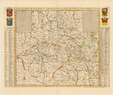
Czech Republic (Carte du Royaume de Boheme. La Chronologie de ses Rois. Les Etats de Silesie, Moravie, et Lusace), Chatelain, Atlas Historique…, Amsterdam, ca. 1708. 24.5 x 18.3”. (HC) This is a very attractive and informative map of the region of present-day Czech Republic, Slovakia and southeastern Poland. At the sides are lists of towns and dukedoms, along with a chronological history of the dukes and kings of Bohemia. In the upper corners are four finely rendered coats of arms for Bohemia, Monrovia, Silesia, and Lusace. The map is adorned with miniature bird`s-eye views of major towns and a compass rose at lower left. Issued folding with minute holes at fold intersections. (A)

Switzerland (Lacus Lemanni Locorumque Circumiacentium Accuratissima Descriptio), Blaeu, Novus Atlas, Amsterdam, ca. 1645. 20.5 x 16.3”. (HC) This beautifully engraved chart of the vicinity of Lake Geneva in Switzerland is based the work of Swiss theologian Jacques Goulart. It is filled with minute detail including estates, vineyards, parks, fortified cities, tiny villages, and several notations concerning the Duke of Savoy`s numerous attempts to gain control over Geneva. The map is richly embellished with a compass rose, sail boats and fishermen in the lake, and three decorative cartouches. The title cartouche is topped with the coat of arms of Geneva supported by cherubs in military garb. French text on verso. Old color with slightly uneven toning and a centerfold separation that just enters map at bottom that has been repaired with old paper on recto, covering up the neatline. There are a few spots and some errant marks of color. (B)

Russia (Tabula Russiae ... M.DC.XIIII), Blaeu, Amsterdam, ca. 1644. 21.6 x 16.8”. (HC) This is Blaeu`s version of Hessel Gerritsz` rare and significant map of Russia, which he compiled from manuscripts brought back by Isaac Massa. The map covers the European part of the Russian Empire extending from Poland to the steppes of Tartary, and from the Mourmanskoy More (Barents Sea) to the Black and Caspian Seas. The large inset plan of Moscow is attributed to the Crown Prince Fydor Gudonov. The map is richly decorated with a large title cartouche, sailing ships, a compass rose, three Russian gentlemen, and an inset view of Archangel Sckagoroda. French text on verso. A good impression and attractive color with light toning along centerfold and a centerfold separation that enters 2" into map at bottom that has been closed on verso with old paper. There are minor damp stains and two archivally repaired tears in blank margins, not affecting map. (+B)

Moscow, Russia (Moscva), Merian, Neuwe Archontologia cosmica, Frankfurt, ca. 1650. 13.9 x 10.8”. (HC) Great bird`s-eye plan displaying Moscow situated at the junction of the Moskva and Neglinnaya Rivers, which form a moat protecting all but the northeast flank of the Kremlin. The map shows the Kremlin and old city, Kitay-gorod, at center. These are surrounded by successive rings of fortifications in an elegant and superbly well-protected metropolis. The plan is ornamented with a coat of arms, simple compass rose and a key to the numbered features, quarters and buildings contained in a monument-style cartouche. Watermarked paper with minor foxing and a few tiny chips and tears all confined to the blank margins. (A)
![Balkans ([Lot of 2] Sclavonia, Croatia, Bosnia cum Dalmatiae Parte [and] Karstia, Carniola, Histria et Windorum Marchia), Bla](http://lot-images.atgmedia.com/SR/36385/2862480/649-2012510165548_468x382.jpg)
Balkans ([Lot of 2] Sclavonia, Croatia, Bosnia cum Dalmatiae Parte [and] Karstia, Carniola, Histria et Windorum Marchia), Blaeu, Amsterdam, ca. 1680. 19.4 x 15”. (BW) Two detailed maps of the Balkans, each of which includes a strapwork title cartouche that credits the map to Gerard Mercator. There is no text on back of either map, indicating they were issued after the demise of the great Blaeu publishing empire, as these were among the plates auctioned in 1677 following the fire that destroyed the printing house. A. Sclavonia, Croatia, Bosnia cum Dalmatiae Parte. The course of the Danube and its tributaries across the northwestern Balkans is the focus of this handsome map. It shows the political divisions of Slovenia, Croatia, Bosnia, Serbia and Dalmatia and locates even the tiniest hamlets. The coats of arms of the Venetian Republic, Habsburg Monarchy, and Ottoman Empire reflect the power struggle that dominated this region. B. Karstia, Carniola, Histria et Windorum Marchia. A fine map of the northern tip of the Adriatic Sea and the Gulf of Venice, present-day northeastern Italy, Slovenia and Croatia. Decorated with a title cartouche, compass rose, distance scale cartouche and a sailing ship. Both have a few faint spots with light foxing and paper has been added in blank margins to repair several chips. Backed with Japanese tissue. (+B)

Italy (Regni Neapolitani Verissima Secundum Antiquorum et Recentiorum Traditionem Descriptio, Pyrrho Ligorio Auct.), Ortelius, Theatrum Orbis Terrarum, Antwerp, ca. 1573. 19.8 x 14.5”. (HC) This is a beautiful map of southern Italy with north oriented to the left as identified by the handsome compass rose. The map is filled with detail and based on the work of Pirro Ligorio who was best known as an architect involved in the building of St. Peter`s in Rome. The title is contained in a flowing banner and a fine sailing ship further adorns the map. Dutch text on verso. Ref: Van den Broecke no.139 Attractive old color on watermarked paper with an abrasion at lower right corner resulting in minor loss of border. There are damp stains in blank margins, barely entering map at bottom corners. (+B)

Northern Italy (Dominio Veneto nell` Italia), Blaeu, Amsterdam, ca. 1640. 19.5 x 15”. (HC) This decorative map of the region of Veneto is roughtly centered on Venice and extending to Milan in the west. Numerous towns and cities are named, with larger cities illustrated with miniature bird`s-eye views. The extensive river system throughout the region is well depicted, in addition to the mountainous topography. Veneto`s coat of arms, depicting the lion of Saint Mark, is at top left, balanced by a distance scale cartouche surmounted by putti measuring a globe at top right. The map is further embellished by ships, a compass rose, and a decorative title cartouche featuring putti and a long ribbon listing the names of important towns in the region. French text on verso. Attractive color with wide margins, light toning, and a few unobtrusive spots. (+B)

Sicily, Italy (Sicilia Regnum), Jansson, Amsterdam, ca. 1657. 19.5 x 15.8”. (HC) This is a strikingly graphic map of the Kingdom of Sicily. The map is filled with topography and towns, including Palermo, Syracuse, Messina, as well as the erupting Mt. Aetna and Lake Pergusa, the mythological place where the goddess Persephone was taken into the underworld. The map is richly decorated with a large coat of arms, two deftly engraved compass roses, and a variety of ships. Across the bottom a fabulous cartouche shows the return of Persephone accompanied by an entourage of sea nymphs. A nice impression with wide original margins and a few pencil marks on the map. There is some minor paper restoration along centerfold at bottom with a bit of the rhumb line in facsimile. There are two very short tears near Palermo and northeast of Randazzo, and a tiny hole near Madoni M. that have all been archivally repaired. (B)

Gibralter (Carte Nouvelle de l`Isle de Cadix & du Detroit de Gibraltar), Homann Heirs, Nuremberg, ca. 1730. 18.8 x 22”. (HC) This extremely attractive map of the Strait of Gibraltar was a collaborative effort between Jean de Petit (royal engineer and architect) and Johann Friedrich Weidler (mathematician and astronomer at Witenberg). It was engraved by R.A. Schneider. The map covers the tips of southern Spain and northern Africa in great detail showing forts, cities, farms, mountains, local roads and rivers. The numerous fortifications guarding this strategic waterway are the focus of the map, which is richly adorned with a brilliant compass rose, three large sailing ships and a fine title cartouche depicted on an animal hide. Bold original color with a few spots of foxing and light printer`s ink residue. There is a tear in right blank margin that just touches neatline. (B)

Crete (Candia met de Omleggende Eylanden), Doncker, Nieuw Groot Stuurmans Straets-Boeck, Amsterdam, ca. 1664. 20.2 x 15.5”. (HC) This very rare sea chart features Crete and surrounding islands. It is decorated with a strapwork and garland style title cartouche, three different scales of miles, two compass roses with north oriented to the right, and is filled with rhumb lines. There is a tiny hole to the right of Crete, a few faint spots, and some very light marginal soiling. (+B)

Eastern Mediterranean (De Reyzen van Paulus, uyt de Handelingen der Apostelen opgemaakt), Goeree, Amsterdam, ca. 1730. 15.2 x 6.8”. (HC) This colorful map of the eastern Mediterranean depicts the route of Apostle Paul from the Holy Land to Rome. The pictorial title cartouche and compass rose decorate the lower left corner of the map. Issued folding with marginal soiling and a few tiny worm holes in blank margins. (A)

Eastern Mediterranean & Middle East (De Beschryving van de Reysen Pauli, en van de Andere Apostelen…), Avelen, Leiden, ca. 1700. 18 x 14”. (HC) This beautiful map of the eastern Mediterranean region details the travels of Apostle Paul. It is richly decorated with scenes from St. Paul`s travels in vignettes along the top and bottom and numerous sailing ships and a compass rose in the sea. Dutch text on verso. Ref: Poortman & Augusteijn no.153. Issued folding with wide margins. There are a few minute holes only visible when held to light and a couple of minor spots. There is a small, professionally repaired hole at a fold intersection in title cartouche. (+B)

Eastern Mediterranean and Middle East (Tabula Geographica, in Qua Omnes Regiones, Urbes, Oppida, et Loca Describuntur, quorum mentio sit in Actis et Epistolis Apostolorum, et Apaocalypsi…), Plancius/Cloppenburg, Amsterdam, ca. 1643. 19.3 x 11.3”. (HC) This superb, graphic map of the eastern Mediterranean, from Rome to Babylon, depicts the spread of Christianity as reported in the Acts of the Apostles. This is the final map of the standard set of five Holy Land maps normally found in Dutch Bibles. The map is surrounded by fifteen Biblical vignettes including the apostles receiving heavenly inspiration, and the events of the Apocalypse as in the book of Revelations. The map includes a small inset of the whole Mediterranean region and is further decorated with a compass rose, sailing ship and strapwork distance scale. This is the second state with Plancius` name in the cartouche replaced by D.R.M. Mathes. Dutch text on verso, from a Dutch Bible published by Cloppenburg. Ref: Poortman & Augusteijn no.82; Laor no.570. Marginal soiling with professionally repaired fold separations in blank margins. (A)

Holy Land (Het Beloofde Landt Canaan. Door-Wandelt van onsen Salich Maaker Jesus Christus…), Schut, Amsterdam, ca. 1730. 19.5 x 13.5”. (HC) This finely engraved and very detailed map of the Holy Land is embellished with sailing ships showing the route of St. Paul to Rome and a compass rose. Second state with Danckerts` imprint replaced by R. & J. Wetstein & William Smith (Amsterdam) and Samuel Luchtmans (Leiden). Dutch text on verso. Ref: Poortman & Augusteijn no.163. Issued folding, with light marginal soiling. (A)

Asia (A New Map of Asia, Divided into its Empires and Kingdoms, with all the European Settlements in the East Indies…), Sayer, London, ca. 1757. 37.5 x 22.5”. (HC) This uncommon, large map of Asia extends west to the eastern Mediterranean and the Red Sea. Sayer gives credit to D`Anville and Robert de Vaugondy for the improvements in cartography. The Korean peninsula is truncated, and Japan with Land of Yezo (Hokkaido) are too large. In the northeast corner are two fictitious islands, Company`s Land and Land seen by Juan de Gama, which were supposedly discovered by Jean de Gama. Vitus Bering finally debunked the myth of the islands in his explorations of the area in 1729, but the islands remained on maps for almost 50 years until Cook confirmed Bering`s reports. The direction of the trade winds is shown in the seas. Insets of the Dardanelles, the Gulf of Smyrna (Izmir), Bombay (Mumbai), and the Hooghly River detail important centers in the British Empires’ quest to dominate trade with Asia. A detailed table at bottom left outlines the divisions within Asia by the Eight Principal Parts and the European Settlements. The map is adorned with a compass rose and an elaborate title cartouche surrounded by images of the Orient. Printed on two sheets, joined as issued. Old color and wide margins with light toning along centerfold, a few minor creases, and one tiny hole. A few short tears in blank margins, and one that enters 2" into map image at right, have been professionally closed on verso with Japanese tissue. (+B)

Northern Asia (Tabula Tartariae et majoris partis Regni Chinae), Wit, Amsterdam, ca. 1685. 21.5 x 17.2”. (HC) Fine map of the region from the Caspian Sea through China and Japan. Eastern Russia is truncated with no Kamchatka peninsula and Yedso is shown according to the voyages of De Vries. The Great Wall is prominently shown separating China from the interior deserts. The mythical Chiammay Lacus is shown with its five major rivers. A strapwork title cartouche with two putti and a compass rose ornament the chart. There are professional repairs of a few centerfold separations and tears along centerfold, as well as tears and chips in blank margins. Light toning along centerfold and discoloration in a few areas due to cello tape used to repair tears, which has since been removed. Manuscript page number in upper right corner. (+B)

Eastern Asia (Suite de l`Ocean Oriental Contenant les Isles de la Sonde les Costes de Tunquin et de la Chine les Isles du Japon les Philippines Moluques), Bellin, Paris, 1746. 12 x 11.5”. (HC) Very handsome sea chart of the region from Korea and Japan through New Guinea. Several coastal towns are noted, but little is depicted in the interior. Japan is shown in Bellin`s distinctive style, and there is good detail of the islands of Indonesia. The chart is centered around a striking compass rose with radiating rhumb lines and is further decorated with a delicately engraved title cartouche. Issued folding with minor offsetting, a few archivally repaired fold separations, and a binding trim at left that has been repaired with old paper. (+B)
-
36562 Los(e)/Seite