An unusual early 19th century walnut astronomy table, the top having a revolving parquetry compass rose, mother of pearl and ebony inlaid, the rose with concentric bands and radiating depressions, within floral marquetry reserves, raised on a later baluster turned tripod base with scroll feet, 73cm high x 62cm square.
36562 Preisdatenbank Los(e) gefunden, die Ihrer Suche entsprechen
36562 Lose gefunden, die zu Ihrer Suche passen. Abonnieren Sie die Preisdatenbank, um sofortigen Zugriff auf alle Dienstleistungen der Preisdatenbank zu haben.
Preisdatenbank abonnieren- Liste
- Galerie
-
36562 Los(e)/Seite
A tin containing a quantity of coronation and commemorative medals, coins, silver brooch, pipe etc. (Q) CONDITION REPORT: A large number of items including compass, cap badge, rifle club medal, map odometer, mounted one dollar piece dated 1883, horn pipe, George VI medal, 1914/1915 medal, four commemorative medals, silver heart medal, coronation medal, four crowns, lapel badge, copper and white metal coins.
Dublin. Collins (Capt. Greenville), Dublin Bay, c.1790, uncoloured engraved sea chart, compass rose and numerous rhumb lines, some offsetting and toning, 450 x 570mm, together with Tallis (John & Co., pubs.), Dublin, c.1840, uncoloured engraved town plan decorated with six eng. vignettes, 360 x 480mm, with another example similar, with S.D.U.K. (pubs.), Dublin, c.1840, engraved town plan with sparse contemp. hand colouring, 320 x 405mm, with another example similar, plus another seven town plans, panoramas and maps of the environs of Dublin including examples by Letts, S.D.U.K. and Weller, various sizes and condition (12)
Durham. Speed (John), The Bishoprick and Citie of Durham, pub. Thomas Bassett & Richard Chiswell, [1707 or later], hand coloured engraved map, inset town plan of Durham, ribbon cartouche and compass rose, 380 x 500mm, no text on verso. Although the map has the Thomas Bassett & Richard Chiswell publication line - which would indicate an edition of 1676 - the map clearly shows engraved roads which are normally only found on the Overton, Jefferys and Dicey editions of 1707 and later. (1)
Gloucestershire. Greenwood (C.& J.), Map of the County of Gloucester from an Actual Survey made in the year 1823, pub. Greewood & Pringle, 1824, large engraved map on two sheets, contemp. hand colouring, sectionalised and laid on linen, calligraphic title, table of explanation, compass rose and uncoloured engraved vignette of Gloucester Cathedral, slight staining and spotting, marbled end papers, overall size 1470 x 1285mm, contained in contemp. speckled calf bookbox with contrasting morocco label to spine, a little rubbed at extrems. (1)
Sea charts. Grierson (George, pubs.), A New and Exact Draught of the Channell of Bristol from Hartland Point to the River Avon and from Caldy Isle to Red Cliff, by Capt. John Williams, pub. Dublin, c.1750, uncoloured engraved chart, two compass roses and numerous rhumb lines, some water staining, old folds, one fold split, very slight fraying, 455 x 790mm, together with A Large Chart Describing the Sands, Shoales, Depth of Water and Anchorage of the East Coast of Scotland North Britain by John Marr, pub. Dublin, c.1750, uncoloured engraved sea chart, compass rose and numerous rhumb lines, old folds, some fraying with slight loss, 485 x 570mm, with Collins (Capt. Greenville), Holy-Head, n.d., c.1700, hand coloured engraved sea chart, compass rose and numerous rhumb lines, 455 x 565mm, plus De la Rochette (Louis Stanislas D’Arcy), A Chart of the British Channel and The Bay of Biscay with part of the North Sea and the Entrance of St. George’s Channel, 1780, hand coloured engraved map, slight staining, slight offsetting, 525 x 720mm, with one other similar (5)
West Africa. Van Keulen (Johannes), Paskaart van de Kuste van Gualate en Arguyn....., Amsterdam, c.1700, engraved sea chart with contemp. hand colouring, orientated to the east, large and decorative cartouche and mileage scale, compass roses and numerous rhumb lines, slight oxidisation to early water colour, slight browning, 515 x 590mm (1)
*Yorkshire. Greenwood (C. & J.), Map of the West Riding of the County of York from an Actual Survey, 1834, engraved map with contemp. hand colouring, b & w engraved vignette of Ripon Cathedral, 640 x 800mm, framed and glazed, together with Blome (Richard), A Mapp of Richmond Shire being part of the North Rideing of Yorke Shire, [1673], hand coloured engraved map, ornate strapwork cartouche, 230 x 285mm, framed and glazed, with Collins (Capt. Greenville), Burlington Bay, Scarbrough & Hartlepoole, n.d., c.1700, three hand coloured charts on one sheet (as published), each with compass rose and numerous rhumb lines, 445 x 565mm, framed and glazed, plus Merian (Matthaus), Tabula Portuum Barbariae junctis Insulis Canariensibus, n.d., c.1640, hand coloured engraved map, 270 x 355mm, mounted, framed and glazed (4)
A Continental Art Deco synthetic sapphire and diamond plaque brooch, oval pierced form with stepped sides and a brilliant cut diamond milligrain set to the centre, pierced and engraved milligrain edge bands, set with rose cut diamonds, and sets of scissor cut synthetic sapphires to the compass points, tested as approximately 18ct gold faced with platinum
A 9ct gold wedding ring, a sterling silver belcher chain, sterling silver compass, a rolled gold part dress set, a cased set of six mother of pearl buttons, a row of simulated pearls with a barrel clasp, marked 9c, a sterling silver charm bracelet, a twig coral necklace, three compacts, a pair of gold earrings, and two others
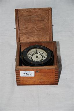
An unusual lantern-style heavy brass timepiece with four feature dials - time, date and day, aneroid barometer and top-mounted compass. Inscription inside Bte SGDG Depose; inscription to front Mohican 1st June 1885. Possible connection with the Mohican French battle which commenced on the same date, all on block and ball nickled feet
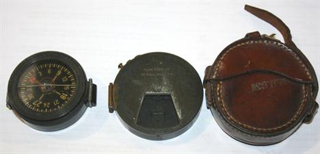
GEORGE V ENGINE TURNED SILVER NAPKIN RING, initialled, TOGETHER WITH A CIRCULAR POTTERY SCENT BOTTLE with pansy design and match screw-off silver stopper, Birmingham 1905, an ELECTROPLATED POCKET COMPASS with ring suspension, in circular case and a FLORAL ENGRAVED WHITE METAL POCKET ASHTRAY (4) EST 25 - 40
A most uncommon Sea Captain's Ebony Walking Stick, the handle with a brass terminal incorporating a high quality compass by ''Dollond, London'' inscribed with the 16 points of the compass with degree graduations east and west of North and South, this unscrewing to reveal a screw-removable three-draw brass telescope extending to 16 13/16'' maximum length. The stick, 36'' long overall approx.
Five pieces of Mauchline ware, comprising; a circular box containing a compass (Shanklin Old Church), 4.7cm, a book, Lady of The Lake, David Bryce & Son (Callender and Bed Ledi), 8.7cm x 6.2cm, a bookmark (West Cowes, Isle of Wight), 12cm, a notebook (Scarborough/Spa Saloon and Italian Terrace ...), 9.2cm x 6.2cm, and an acorn form go-to-bed (Brighton Pier), match mount a.f., 5.5cm. (5)
-
36562 Los(e)/Seite


