

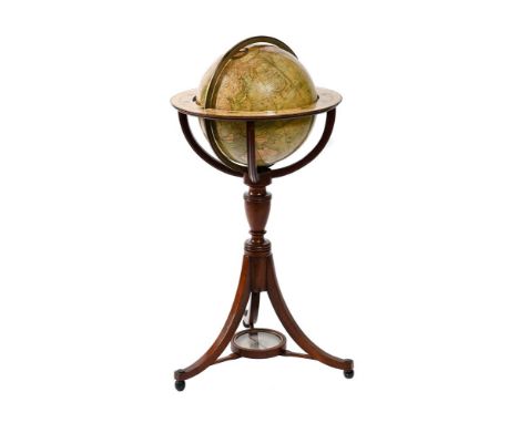
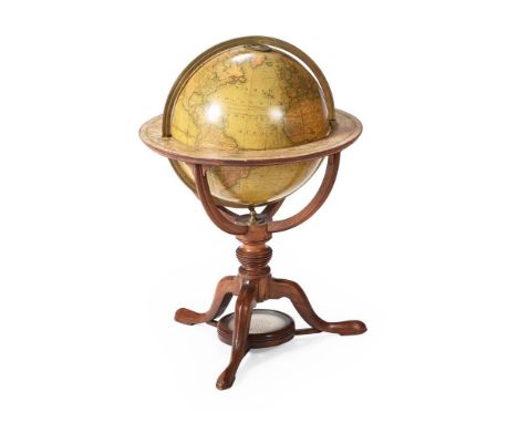
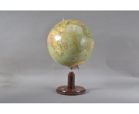
A WILLIAM IV FIFTEEN-INCH TERRESTRIAL LIBRARY TABLE GLOBEG. AND J. CARY, LONDON, CIRCA 1832The sphere applied with two sets of twelve hand-coloured engraved split half-gores incorporating circular panel inscribed CARY'S, NEW, TERRESTRIAL GLOBE, Drawn from the most recent, GEOGRAPHICAL WORKS, shewing the whole of the New Discoveries, with the, TRACKS of the PRINCIPAL NAVIGATORS, and every improvement in Geography, to the present time., LONDON, London Published by G. & J. CARY, St James's Street, Jan'y 7th, 1832 to North Pacific, with extensively annotated and fully graduated equatorial and the Pacific ocean with an analemma for the TABLE of EQUATION, the oceans with many explorers' tracks and numerous notes and dates, Antarctica with minimal land shown including SOUTH SHETLAND, Powells Group and Sandwich Land, the continents with nation states faintly colour-outlined, showing cities, towns, rivers, mountains in pictorial relief, pivoted via the polar axis within brass meridian circle divided for degrees and with brass hour circle to North pole, set within engraved paper horizon ring with compass points and degrees in both directions, Zodiac, calendar scales and wind directions, the stand comprising four mahogany baluster turned supports united by a conforming cross-stretcher.53cm (21ins) high, 51.5cm (20.25ins) diameter overall. The celebrated Cary family business of scientific instrument and globe makers was established by John Cary at Johnson's Court, Fleet Street, London in 1782 moving to a new address at 'Corner of Arundel Square', Strand the following year. He was primarily an engraver of maps, charts and globes who moved again in 1783 to 188 Strand. By 1791 he had entered into what appeared to be a relatively casual partnership with his brother, William; this partnership lasted until circa 1816 by which time William and John Cary had moved again to 181 Strand before finally settling in 86 St. James in 1820. The following year he was succeeded by his sons, John (II) and George Cary, who continued from the firm's 181 Strand address until 1851/2 when the business was acquired by Henry Gould.Condition Report: Globe is generally in relatively original 'country house' condition. The sphere retains old colouring beneath a coat of relatively recently applied varnish. This recently applied coat of varnish is somewhat unevenly executed with a few light runs and sags. There is some historic damage beneath the varnish mainly old flaking to the original varnish and scuffing the worst of which being three vertical touched-in scratches passing through Europe down into Africa a large patch of previous varnish loss to the centre of Africa and a smaller area of similar damage to North America. There is also some concentric rubbing/scratching adjacent to the Tropic of Cancer and the equator (commensurate with something rubbing between the brass meridian ring and the globe itself whilst the sphere is being rotated. The bottom pole has some cracking, movement and slight losses around the pivot and the top has some slight opening to the gores beneath the hour circle. The meridian ring and hour circle are in good original albeit dirty/discoloured condition and the globe rotates comfortably without rubbing. The brass bottom mount (that locates with and hods the meridian ring steady) The stand is in sound original condition with the horizon papers complete and in comparable condition as the globe and the woodwork with relatively minor age-related bumps, scuffs and wear. Condition Report Disclaimer
36562 Preisdatenbank Los(e) gefunden, die Ihrer Suche entsprechen
36562 Lose gefunden, die zu Ihrer Suche passen. Abonnieren Sie die Preisdatenbank, um sofortigen Zugriff auf alle Dienstleistungen der Preisdatenbank zu haben.
Preisdatenbank abonnieren- Liste
- Galerie
-
36562 Los(e)/Seite

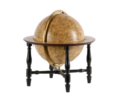
A GEORGE IV TWELVE-INCH TERRESTRIAL FLOOR-STANDING LIBRARY GLOBEG. AND J. CARY, LONDON, CIRCA 1828The sphere applied with two sets of twelve hand-coloured engraved split half-gores incorporating circular panel inscribed CARY'S, NEW, TERRESTRIAL GLOBE, DELINEATED, From the best Authorities extent;, Exhibiting the late Discoveries towards the, NORTH POLE, and every improvement in Geography, to the present Time., LONDON, Made & Sold by G. & J. CARY, 86 St James's Street, Jan'y 4, 1828 to North Pacific, with extensively annotated and fully graduated equatorial and the Pacific ocean with an analemma for the TABLE of EQUATION, the oceans with many explorers' tracks and numerous notes and dates, Antarctica with no land shown but Jan'y 30th 1774, Firm Fields and Vast Mountains of Ice 71.10 Highest South Lat of Capt. Cook and other notes, the continents with nation states faintly colour-outlined, showing cities, towns, rivers, mountains in pictorial relief, pivoted via the polar axis within brass meridian circle divided for degrees and with brass hour circle to North pole, set within hand coloured engraved paper horizon ring with compass points and degrees in both directions, Zodiac, calendar scales and wind directions, in a stand with four down-curved quadrant supports cradling the globe over baluster-turned upright and three outswept supports terminating with acorn feet.88cm (30.5ins) high, 43cm (17ins) diameter overall. The celebrated Cary family business of scientific instrument and globe makers was established by John Cary at Johnson's Court, Fleet Street, London in 1782 moving to a new address at 'Corner of Arundel Square', Strand the following year. He was primarily an engraver of maps, charts and globes who moved again in 1783 to 188 Strand. By 1791 he had entered into what appeared to be a relatively casual partnership with his brother, William; this partnership lasted until circa 1816 by which time William and John Cary had moved again to 181 Strand before finally settling in 86 St. James in 1820. The following year he was succeeded by his sons, John (II) and George Cary, who continued from the firm's 181 Strand address until 1851/2 when the business was acquired by Henry Gould.Condition Report: Globe is in sound original unrestored condition with no visible losses or infilling to the gores or problematic cracks. The lower pole shows some evidence of slight movement and the joins between the papers have opened-up a little. The sphere retains its original varnish however this is now friable and crazed hence has patchy losses throughout. A section of varnish has been cleaned off (Bay of Bengal); where the original finish is undisturbed the print is clear and colouring discernable albeit beneath the yellowy brown glaze. The stand is in sound original unrestored condition; the Horizon papers are heavily faded with cracks visible at the joints to the wooden frame. The polish is faded/flat.Please note additional images are available which form an integral part of the condition report. Condition Report Disclaimer
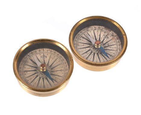
A PAIR OF FRENCH LACQUERED BRASS COMPASS DIALSUNSIGNED, EARLY 19th CENTURYEach with printed paper scale incorporating sixteen-point rose labelled with the four principal cardinal points within outer track annotated in ten degree increments and divided for every five, the half blued steel needle with jewelled pin pivot set behind glass secured to the cylindrical case via an engine-milled bezel.Each 5.7cm (2.25ins) diameter, 1.5cm (0.625 ins) high. Condition Report: Both with some light foxing/browning to the paper scale as well dust ingression. the cases with slight wear/discolouration to the lacquered finish only.Condition Report Disclaimer
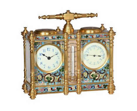
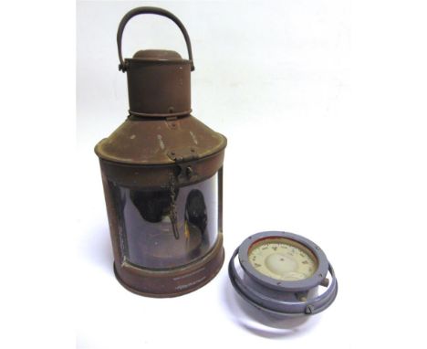
A FRENCH GILT AND CLOISONNE ENAMEL CARRIAGE TIMEPIECE AND BAROMETER WITH COMPASS AND THERMOMETERTHE TIMEPIECE BY DUVERDRY AND BLOQUEL, CIRCA 1890The eight-day single train movement with replaced gilt platform lever escapement regulated by sprung monometallic balance and stamped with the 'lion' trademark for Duverdry and Bloquel to backplate, the circular blue on cream Arabic numeral dial with vertically orientated numerals and blued steel hands set within a rectangular polychrome cloisonne enamelled mask decorated with scrollwork on a powder blue ground, the aneroid barometer mechanism set beside the timepiece constructed with vacuum chamber and rack motionwork within plates united by four pillars matching those of the timepiece, the circular blue on cream register calibrated in millimetres of mercury and with weather observations in French, with blued steel pointer and set within an enamel mask matching that of the timepiece, the bevel-glazed frosted gilt brass case with reeded T-shaped carrying handle over convex glazed circular escapement aperture opposing a conforming silvered brass compass with eight points annotated in French, the angles with button finials over projecting reeded columns to angles joined by bands of blue ground enamel scrollwork to frieze and apron, the centre with silvered mercury tube CENTIGRADE thermometer set between conforming subsidiary pilasters to front, the sides with glazed panels and the rear with conforming twin doors with blind panel between, on turned feet applied to the projecting angles.16cm (6.25ins) high, 16.5cm (6.5ins) wide, 7cm (2.75ins) deep. The clockmaking factory of Duverdry and Bloquel is noted by Leigh Extence as originally founded by Albert Villon in the town of Saint-Nicolas-d'Aliermont in 1867. Paul Duverdry joined the firm as a director in 1887 followed by Joseph Bloquel in 1910.Condition Report: Timepiece movement is in relatively clean working condition and appears all original except for the platform escapement which is a modern replacement. The barometer mechanism is also in relatively clean working condition (has been 'bag tested' and response to change in pressure observed). The enamel disc of the timepiece dial has a light vertical hairline crack travelling from the centre up through the 12 numeral otherwise both dials are free from visible faults. The case is in fine condition with no visible damage to the enamel or noticeable chips to the glasses. The thermometer is intact and working with only some slight mellowing to the silvered scale. The gilding is in fine condition exhibiting minimal wear/discolouration.Timepiece has a winding key. Condition Report Disclaimer
AN EARLY VICTORIAN TWELVE-INCH TERRESTRIAL FLOOR-STANDING LIBRARY GLOBEPUBLISHED BY S.S. EDKINS SUCCESSORS TO T.W. BARDIN, SOLD BY J. SOUTER, LONDON, CIRCA 1837The sphere applied with two sets of twelve hand-coloured engraved gores and polar calottes incorporating circular panel inscribed THE, NEW TWELVE-INCH, BRITISH, Terrestrial Globe, REPRESENTING THE, ACCURATE POSITION OF THE PRINCIPAL, KNOWN PLACES OF THE EARTH., FROM THE DISCOVERIES OF, CAPTAIN COOK, AND SUBSEQUENT CIRCUMNAVIGATORS, TO THE PRESENT PERIOD, 1837 over applied curved label J. Souter, School Library, 151 Fleet St. London to North Pacific, with extensively annotated and fully graduated equatorial and the Pacific ocean with THE ANALEMMA for the equation of time, the oceans with many explorers' tracks and numerous notes and dates, Antarctica with no land shown except for Enderby's Land dated 1833, the continents with nation states faintly colour-outlined, showing cities, towns, rivers, mountains in pictorial relief, pivoted via the polar axis within brass meridian circle divided for degrees and with brass hour circle to North pole, set within hand coloured engraved paper horizon ring with compass points and degrees in both directions, Zodiac, calendar scales and wind directions, in a stand with four down-curved quadrant supports cradling the globe over vase-turned upright and three outswept supports united by glazed compass stretcher inset with paper printed with elaborate thirty-two point rose within outer scale divided for degrees, terminating with ball feet.88cm (30.5ins) high, 43cm (17ins) diameter overall. The present globe is a known edition by S.S. Edkins (successors to T.W. Bardin). The lower margin of the roundel is applied with Souter's address over the original printed text 'Manufactured by S.S. Edkins Son in Law and Successor to the late T. M. Bardin Salisbury Square London'. William Bardin (1783-98) was a freeman of the Leatherseller's Company who starting making globes in around 1780. His first globes were 9 and 12 inch diameter published in collaboration with Gabriel Wright on 1st January 1782. Wright was a mathematical instrument maker who had previously worked for Benjamin Martin who, in turn, had acquired the plates of Senex's celebrated globes from James Ferguson. William's son, Thomas Marriott, is recorded in Clifton, Gloria Directory of Scientific Instrument Makers 1550-1851 as a globe maker apprenticed to his father, in 1783 with whom he went into partnership in 1790. Bardin and Son initially worked from 4 Hind Court, Fleet Street, London before moving to 16 Salisbury Square in 1975. William Bardin died in 1795 leaving the business in the hands of Thomas Marriott. The firm was taken-on by Thomas's daughter, Elizabeth Marriott, after his death in 1820 and then by her husband, S.S. Edkins. on their marriage in 1832. They took a son into partnership in 1848 and the business continued until shortly after S.S. Edkins's death in 1853. J. Souter appears not to be recorded in the usual sources however online sources suggest that they were specialist publishers and retailers of books and maps for educational purposes and were established before 1820.Condition Report: The glove is generally in good original condition with no visible cracks or noticeable losses/infilling to the gores. The gores have noticeable opening between the sections with some noticeable related staining to the edges. Otherwise notable faults are essentially limited to some historic mottling, greying/blooming to the upper surfaces. The current varnish appears relatively recently applied and is quite 'shiny'. Although the standi is contemporary to the globe we cannot offer any assurances that it is original to the globe. The meridian papers are quite light in colour but in sound condition with minor wear and some visible shrinkage to the ring beneath visible through the papers. There is no brass mount for the meridian ring (just a raised slot in the top of the columns) and one foot has a small spliced repair to the tip. The compass appears in good condition although the paper has probably been 'washed'.Please note additional images are available which form an integral part of the condition report. Condition Report Disclaimer
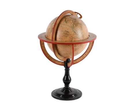
A REGENCY TWELVE-INCH CELESTIAL LIBRARY TABLE GLOBEJ. AND W. CARY, LONDON, CIRCA 1816The sphere applied with two sets of twelve hand-coloured engraved split half-gores incorporating rectangular panel inscribed CARY'S, NEW CELESTIAL GLOBE, ON WHICH, are correctly laid down upwards of 3500 stars, Selected from the most accurate observations, and calculated for the Year 1800., With the extent of each Constellation precisely defined, By MR. GILPIN of the ROYAL SOCIETY., Made & Sold by J. & W. Cary, 181 Strand London, Jan'y 1 1816, the axis through the celestial poles, with fully graduated equatorial and ecliptic with twilight zone, the constellations depicted by mythical beasts and figures with dotted boundaries, the stars shown to seven orders of magnitude with clusters and nebulæ, the upper pole with brass hour dial and pivoted within brass meridian circle divided for degrees, set within hand-coloured engraved paper horizon ring with compass points and degrees in both directions, Zodiac, calendar scales and wind directions, the stand comprising four ebonised baluster turned supports united by a conforming cross-stretcher fitted with a brass support for the meridian ring.46cm (18ins) high, 44cm (17.25ins) diameter overall. The celebrated Cary family business of scientific instrument and globe makers was established by John Cary at Johnson's Court, Fleet Street, London in 1782 moving to a new address at 'Corner of Arundel Square', Strand the following year. He was primarily an engraver of maps, charts and globes who moved again in 1783 to 188 Strand. By 1791 he had entered into what appeared to be a relatively casual partnership with his brother, William; this partnership lasted until circa 1816 by which time William and John Cary had moved again to 181 Strand before finally settling in 86 St. James in 1820. The following year he was succeeded by his sons, John (II) and George Cary, who continued from the firm's 181 Strand address until 1851/2 when the business was acquired by Henry Gould.Condition Report: Globe is generally in fine condition having been carefully and skilfully conserved fairly recently (within the last 25 years or so). There is evidence of minor filling and consolidation of light cracking around the bottom pivot and overall light mottling to the surface. The present surface finish is very even with only a few slight historic blemishes evident beneath the varnish; the hand colouring is faded but still eminently visible. The meridian ring, hour circle and other brass fittings are in fine condition. The meridian papers have also been conserved to a high standard hence condition is commensurate with the globe. The stand has a couple of loose joints (glue has dried-out) otherwise is in sound original condition with some age-related bumps and scuffs evident. Condition Report Disclaimer
A WILLIAM IV TWELVE-INCH TERRESTRIAL LIBRARY TABLE GLOBEJ. ADDISON AND COMPANY, LONDON, CIRCA 1835The sphere applied with two sets of twelve hand-coloured engraved split half-gores incorporating circular panel inscribed J. ADDISON'S, New & Improved, TERRESTRIAL GLOBE, Containing all the latest Discoveries and, GEOGRAPHICAL IMPROVEMENTS, also the Tracks of the most celebrated, Circum Navigators, Carefully Delineated by, J. ADDISON & Co., Globe Makers by appointment, to his Majesty, GEORGE IV, Made and Sold by J. ADDISON, No. 116 Regent Street, London to the North Pacific, extensively annotated with fully graduated equatorial calibrated in minutes and degrees, ecliptic and meridians, the Pacific ocean with an analemma TABLE of EQUATION, many explorers' tracks and numerous notes and dates, Antarctica with no land shown except for Graham's Land and Enderby's Land both dated 1833, the continents with nation states faintly colour-outlined, showing cities, towns, rivers, mountains in pictorial relief including marine topography, with engraved brass hour dial to the North pole and pivoted within brass meridian circle divided for degrees, set within hand-coloured engraved paper horizon ring with compass points and degrees in both directions, pictorial representations of the Zodiac and calendar scales, the tripod stand incorporating four quadrants supporting the meridian ring over reeded squat baluster upright and downcurved supports, with stretcher centred with a glazed paper compass dial printed with elaborate thirty-two point rose within outer scale divided for degrees, and terminating with tapered feet, (compass needle lacking).61cm (24ins) high, 44cm (17.25ins) diameter overall. John Addison is recorded in Clifton, Gloria Directory of British Scientific Instrument Makers 1550-1851 as a Globe maker working from Regent Street, 50 London Street (Fitzroy Square) and 7 Hampstead Road, London 1800 - 1819. He was granted Royal appointment in 1820 and was trading as Addison and Co. after around 1815. Latterly John Addison and Company are recorded working from 9 Skinner Street (Snow Hill) 1800-21, 116 Regent Street 1822-25 and finally 275 Strand 1829-30. Addison is known to have produced terrestrial and celestial globes in many sizes from three inch through to his magnificent thirty-six inch 'Terraqueous Globe'.Condition Report: The globe generally presents as being in good original unrestored condition with nice colouring and clear well-defined detail. There are some areas of stable but noticeable cracking mainly to the lower hemisphere (either side of Australia and to the left of the Analemma) there are no significant losses or unsightly problems with the gores/surface within the areas of cracking hence they are only really noticeable on closer examination. Faults to the rest of the sphere are otherwise limited to minor historic bumps, scuffs and rubbing. The stand is in good original condion albeit a little uneven in colour. The horizon papers are very good (slight mottled age browning only) the compass frame may be an addition and the needle is missing.Please note additional images are available which form an integral part of the condition report. Condition Report Disclaimer
A FRENCH LOUIS PHILIPPE EIGHT-AND-A-HALF INCH TERRESTRIAL LIBRARY TABLE GLOBEFELIX DELAMARCHE, PARIS, CIRCA 1838The sphere applied with two sets of twelve hand-coloured engraved gores and polar calottes incorporating printed text GLOBE, ADOPTE, PAR LE CONSEIL ROYAL DE L'INSTRUCTION PUBLIQUE, PAR, DELAMARCHE, Jugenieuo Geographe, Rue du Jardinet 12, PARIS, 1838 to central Pacific, with fully graduated equatorial, ecliptic, and Meridian passing through Paris, the oceans with islands labelled and Antarctica with no land shown except a fragment labelled Terre de Enderby, the continents with nation states faintly colour-outlined, showing cities, towns, rivers, mountains in pictorial relief, pivoted via the polar axis within paper-covered Meridian ring variously annotated and graduated in degrees and applied with conforming hour chapter ring to the North Pole, set within hand coloured engraved paper horizon ring with compass points and degrees, pictorial representations of the Zodiac and calendar scales, the stand with four down-curved quadrant supports further annotated with latitudes and longitudes de Paris for various cities cradling the globe, over baluster-turned upright and concentric-turned disc-shaped foot.46cm (18ins) high, 30.5cm (12ins) diameter overall. The Delamarche dynasty of Parisian globe makers is recorded in Lamb, Tom and Collins, Jeremy (editors) THE WORLD IN YOUR HANDS, An Exhibition of Globes and Planeteria (held at Christies King Street, London and Museum Boerhave, Leiden 1994-95) as founded by Charles Francois Delamarche (1740-1817) during the latter part of the 18th century. Charles Delamarche first acquired the remaining part of Robert Vaugondy's workshop, republishing their atlases and globes before taking over Jean Fortin's business in 1795. Latterly Delamarche also purchased the stock of Jean Lattree (publisher of the Lalande and Bonne Globes); through these acquisitions Delamarche essentially monopolised the Parisian globe making trade. The business passed to Charles Delamarche's son, Felix, in 1817 who continued production to around 1848.Condition Report: Globe presents as being in good original condition with nice mellow colour. Although it appears essentially untouched the globe has received some light sensitively executed restoration to address slight cracks to East Africa and the Atlantic. There is also some slight filling and restoration to North America/Canada and China. Faults to the sphere are otherwise limited to very light surface rubbing. The Meridian, horizon and other areas of printed paper are in good condition with faults limited to a few very light bumps/scuffs; the rear of the meridian ring (unprinted) has some overpainting to address an area where a section of thin card lining has been lost. The hour ring appears to be a restoration/replacement; the stand has been re-polished over historic bumps, scuffs and scratches.Please note additional images are available which form an integral part of the condition report. Condition Report Disclaimer
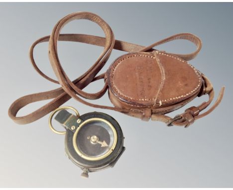

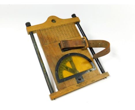
MAP BOARD. A WWI British Army issue map board, stamped Houghton-Butcher, London 1917. The reverse with hand drawn table. Fitted a compass & leather strap. Please note that all items in this auction are previously owned & are offered on behalf of private vendors. If detail on condition is required on any lot(s) PLEASE ASK FOR A CONDITION REPORT BEFORE BIDDING. The absence of a condition report does not imply the lot is perfect.WE CAN SHIP THIS LOT, but NOT if part of a large, multiple lots purchase
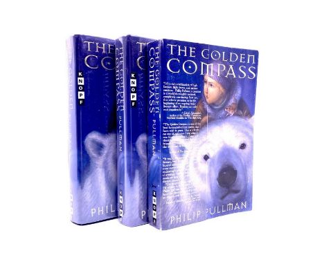
Pullman, Philip. The Golden Compass, two signed US first edition hardbacks, one inscribed, 'For Erik and Tamaradela, with my best wishes - Philip Pullman', the other with a signed Scholastic bookplate, New York: Alfred A. Knopf, 1996, full number lines, '10 9 8 7 6 5 4 3 2 1', unclipped dust-jackets with protective mylar covers, both in fine, unread condition. Together with a first issue Uncorrected Proof of the same, paperback with folding card gate cover, full number line, '1 2 3 4 5 6 7 8 9 10', Knopf, 1996, with loosely-inserted "tell a friend" card, unused, very good condition with light wear to extremities (3)

NAUTICAL BOOKS, approximately twenty titles on the subject of Navigation to include Norie's Nautical Tables with Explanations of their Use, published 1957, Brown's Nautical Almanac 1963, Admiralty Manual of Navigation Vol.1 1964 (ex-School copy) Glossary of Navigation - A Vade Mecum For Practical Navigators of the Royal Navy, Mercantile Marine and Yacht Squadron by the Rev. J.R. Harbord, M.A., R.N., Tables Requisite to be used with the Nautical Ephemeris for finding the Latitude and Longitude at Sea, 3rd edition, published 1802 (front board present but detached) The Mariner's Compass Rectified Containing Tables, by Andrew Wakely, published 1784, Signal Letters of British Ships (formerly The British Code List) 1918, prepared by Charles H. Jones C.B.E.
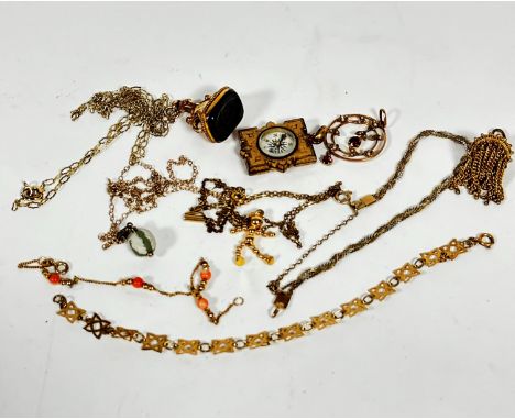
An Edwardian 9ct gold openwork brooch set two garnets and leaf set seed pearls (d.2.5cm), a gilt metal compass style locket, a yellow metal seal with onyx carved Greek style soldier on trace link chain, a Wedgwood pale green jasperware ball on trace link chain, a 9ct gold dancing figure on trace link chain, a yellow metal three coloured bracelet, a trace link bracelet with pink coral, a star shaped trace link chain and a gilt metal tassel (a lot)
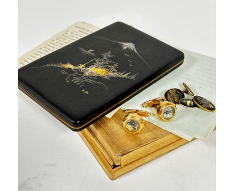
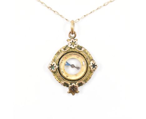
REUGE; a vintage lacquered gilt metal novelty compact / cigarette care and lipstick modelled as a camera, length 9.5cm, with a late 19th century treen pocket compass and sun dial, length 7.5cm (2).Condition Report: The camera with light surface wear throughout but essentially ok, the compass with general age wear to the exterior, the interior fairly clean, the gnomon is broken.
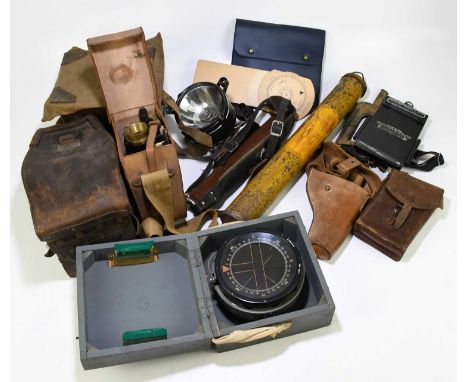
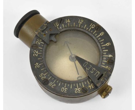
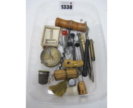
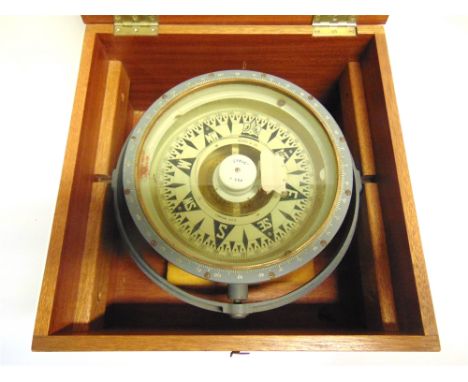
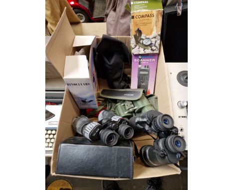
An assortment of military instruments, empty cases and accessories to include a Type P.10 gimballed compass, number 27368 B, in grey pine case, a leather cased part tool set, possibly for a machine gun, a signalling box with light and Morse tapper, a tan leather instrument case (empty), a Helio 5" MK.V F.LTD, a side arm leather case, etc.
![Cary (John). A New Map of Sussex divided into hundreds, exhibiting its roads, rivers, parks &c, 1801 [and] A New map of K](https://cdn.globalauctionplatform.com/14d4f542-a179-4b38-b79b-afa100a4c073/18546ad4-398b-42ad-9baa-afab010b596a/468x382.jpg)
Cary (John). A New Map of Sussex divided into hundreds, exhibiting its roads, rivers, parks &c, 1801 [and] A New map of Kent divided into lathes and subdivided into hundreds exhibiting its roads, rivers, parks, &c, 1806, two engraved maps with contemporary hand colouring, ovoid cartouche and table of reference, each approximately 500 x 570 mm, together with Smith (Charles), A New Map of the county of Surrey divided into hundreds, 1808, engraved map with contemporary hand colouring, tables of reference and explanation, 470 x 520 mm, with Cowley (John), An improved Map of the county of Surrey containing the borough and market towns..., [1744], engraved map with outline colouring, trimmed to neatline and laid on later paper, 130 x 180 mm, mounted, plus Walker (J & C), Kent [and] Devonshire, circa 1835 and circa 1848 respectively, two engraved maps with contemporary outline colouring, each approximately 330 x 400 mm, and Cary (John), Surrey [and] Dorsetshire, 1793 & 1795 respectively, two engraved maps with contemporary outline colouring and some later additional hand colouring, each 220 x 270 mm, mounted, with Archer (J.), Surrey, circa 1848, engraved map with contemporary outline colouring, 190 x 240 mm, mounted and Greenwood (C. & J.). Map of Oxford from an Actual Survey..., 1834, engraved map with contemporary hand-colouring, inset uncoloured vignette of Oxford Cathedral, calligraphic title, explanation and compass rose, slight offsetting, 585 x 710 mmQTY: (10)
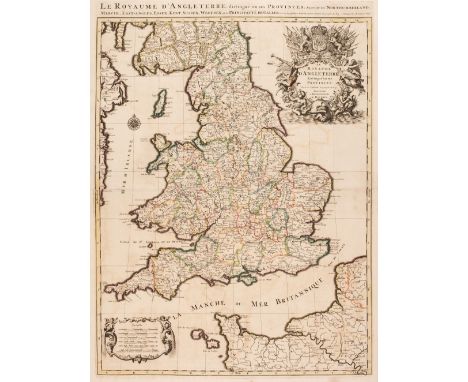
England & Wales. Jaillot (Alexis-Hubert & Sanson Nicolas), Le Royaume d'Angleterre distingué en ses Provinces..., Paris, 1693, large engraved map with contemporary outline colouring, large uncoloured decorative cartouche and mileage scale, title repeated above the map, some offsetting and slight staining, 780 x 580 mm, together with Blaeu (Johannes). Anglia Regnum, Amsterdam, circa 1645, engraved map with contemporary outline colouring, some staining and dust soiling, slight worming, 385 x 495 mm, no text on verso, with Homann (Johann Baptist, heirs of). Regni Angliae et Principatus Cambriae Tabula Nova..., 1793, map engraved by J Rausch with contemporary outline colouring, inset map of the Scilly Isles, uncoloured allegorical cartouche, toned overall, very slight staining, 600 x 530 mm, with another copy similar, plus Hole (Guillaume). Englalond Anglia AngloSaxonum Heptarchia [1610], hand-coloured engraved map, strapwork cartouche and compass rose, slight marginal staining, 280 x 325 mm, and De Wit (Frederick). Accuratissima Angliae Regni et Walliae Principatus..., P. Mortier, Amsterdam, circa 1714, engraved map with contemporary outline colouring, light overall toning, some marginal staining, occasional repaired marginal closed tears, 580 x 490 mmQTY: (6)
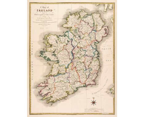
Ireland. Wyld (James), A Map of Ireland Divided into Provinces and Counties shewing the Great and Cross Roads with the distances of the principal Towns from Dublin, 1847, hand-coloured lithographic map, calligraphic cartouche, compass rose and mileage scale, occasional repaired marginal closed tears, 715 x 540 mmQTY: (1)
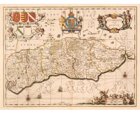
Sussex. Schenk (P. & Valk G.), Suthsexia vernacule Sussex, Amsterdam, circa 1700, hand-coloured engraved and reticulated map, decorative cartouche and mileage scale, compass rose and numerous rhumb lines, 385 x 505 mm, together with Morden (Robert). Sussex [1695 or later], hand-coloured engraved map, 345 x 415 mm, plus Ogilby (John). The Road from London to Newhaven com. Sussex [1675 or later], hand-coloured engraved strip road map, toned overall, some creasing, 335 x 430 mm, QTY: (3)
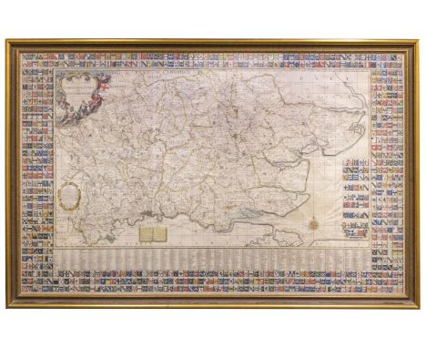
* East England. Warburton (J. Bland J. & Symth P.), A New and Correct Mapp of Middlesex, Essex and Hertford-shire with the Roads, Rivers, Sea Coasts etc., Actually Surveyed by John Warburton, Joseph Bland and Paylor Smith, 1st edition [1725], very large hand coloured engraved map on six conjoined sheets, decorative cartouche, explanation, compass rose and numerous rhumb lines, list of towns and villages below the map and 736 coats of arms surrounding the map, 1155 x 1850 mm, framed and glazedQTY: (1)NOTE:A very fine example of a very large and striking map of part of South East England; remarkable and aesthetically stunning due to the large number of armorials. The map had a large number of subscribers (over 700) but few examples survive, probably due to the temptation to display it as a wall map which would have accelerated the map's mortality.
Cluver (Philip). Introductionis in Universam Geographiam tam veterem quam novam Libri VI, Tabulis aeneis illustrati Accessit P. Bertii Breviarium Orbis Terrarum, Amsterdam: Ex Officina Elzeviriana, 1672, [12], 388 [76]p., engraved decorative title (leaf *1), part title to the Breviarium, 38 uncoloured engraved folding maps (complete as list), lacking the two plates of compass roses (not called for in index list), map of Germany torn along old fold and frayed at margins, map of Persia waterstained, occasional worming to fore margins not affecting text, lacking front free endpapers, contemporary calf, hinges and joints weak and cracked, spine label partially lacking, worn and rubbed, 12moQTY: (1)NOTE:Willems 1467.
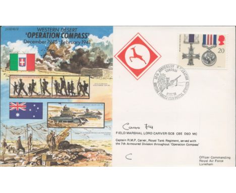
Field Marshal Lord Carver Signed Operation Compass Dec 1940-Feb 1941 FDC. British Stamp with 9 Dec 90 Postmark. Good condition. All autographs come with a Certificate of Authenticity. We combine postage on multiple winning lots and can ship worldwide. UK postage from £5.99, EU from £7.99, Rest of World from £9.99
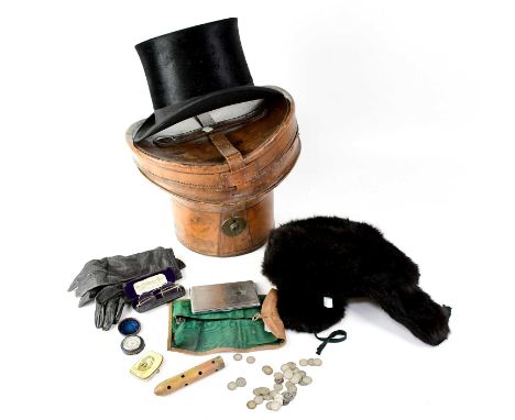
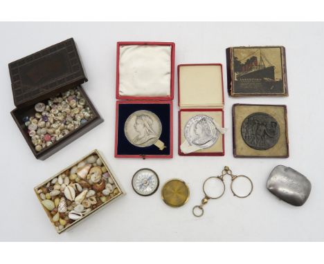
A quantity of collectibles to include a City Cork Hat Company top hat in original leather box, together with a pair of leather gloves, a fur hat, a pair of wire-rimmed spectacles in case, a pigskin roll of manicure items, coins, compass in a case, a steel cigarette box and Blackpool Wheel souvenir coin purse.Condition Report: Inner of top hat 20.5 x 16.5cm
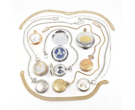
An assorted collection of pocket watches & chains together with pocket compasses. The lot to include; a silver tone moon phase pocket watch on curb link chain, a Smiths gold tone pocket watch, a full hunter Napoleon portrait pocket watch on chain, two gold tone chains, silver tone chain, full hunter duck design with snake chain, an America sports hunting interest design two tone full hunter on snake chain, two eagle design full hunters one in gold tone & the other in silver both on chains together with two pocket compass. Largest measures approx 9x7cm. Total weight approx 708g.
-
36562 Los(e)/Seite