Forty Three Sony Playstaion 2 games, cased, to include Maximo Army Of Zin, I-Ninja, Alien Hominid, Peter Jackson's King Kong, Star Wars Starfighter, Piglet's Big Game, Heavenly Sword, Gran Turismo 5 Prologue, Ben 10 Cosmic Destruction, Assassin’s Creed Revelations, Mercenaries 2 World In Flames, Duke Nukem Forever, Toy Story 3, Ratchet & Clank A Crack In Time, White Knight Chronicles II, Avatar The Game, Ghostbusters The Video Game, Spec Ops The Line, FIFA 11, Saints Row 2, WET, FIFA Street, Command & Conquer Red Alert 3 Ultimate Edition, Fracture, Viking Battle For Asgard, Of Orcs And Men, Resistance Fall Of Man, Disney Pixar Ratatouille, Killzone 3, Uncharted 3 Drake’s Deception, FIFA 08, Call OF Juarez Bound In Blood, FIFA 10, Clive Barker’s Jericho, FIFA 12, The Golden Compass, Darksiders, Ratchet & Clank Tools Of Destruction, Risen 2 Dark Waters, Conan, Golden Axe Beast Rider, Disney Bolt and Syndicate, together with seven Playstation 2 games, cased, to include Spider-Man 3, Lego Star Wars II The Original Trilogy, WWE Smackdown Vs Raw 2008, Final Fantasy X, The Incredibles, Final Fantasy XII and Ratchet & Clank Locked And Loaded, also including a DJ Hero Controller


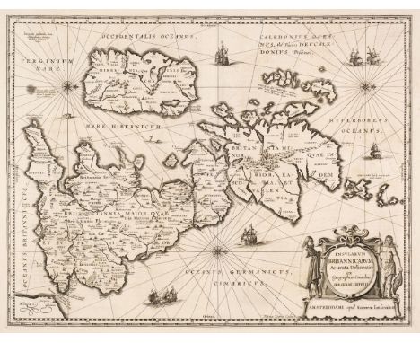
![* Cornwall. Speed (John & Norden John), Cornwall, Thomas Bassett & Richard Chiswell [1676], uncoloured engraved map,](https://cdn.globalauctionplatform.com/f2d55b0d-bea0-4ba1-96c5-af5f00b8a264/82db9b1f-15e2-4f10-a51f-af5f011dc4b8/468x382.jpg)

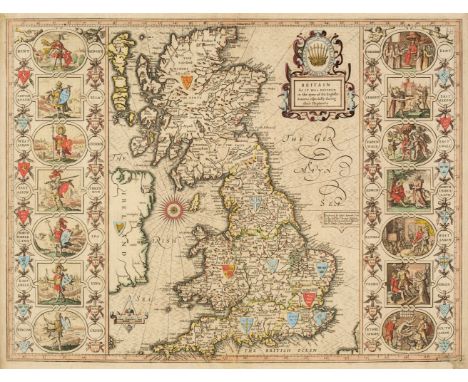
![North Wales. Speed (John), Montgomery, Flint & Denbighshire..., [1611 - 27], three county maps, including Montgomery Shir](https://cdn.globalauctionplatform.com/f2d55b0d-bea0-4ba1-96c5-af5f00b8a264/99f5e414-f0f9-4c17-b2e3-af5f011de9ef/468x382.jpg)
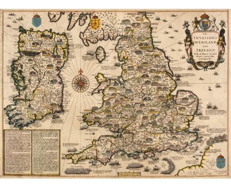
![* Wales. Speed (John), Caermarden Both Shyre and Towne Described, John Sudbury & George Humble [1627], hand-coloured engr](https://cdn.globalauctionplatform.com/f2d55b0d-bea0-4ba1-96c5-af5f00b8a264/9a552261-fde4-4af4-a6f7-af5f011e04fe/468x382.jpg)