36562 Preisdatenbank Los(e) gefunden, die Ihrer Suche entsprechen
36562 Lose gefunden, die zu Ihrer Suche passen. Abonnieren Sie die Preisdatenbank, um sofortigen Zugriff auf alle Dienstleistungen der Preisdatenbank zu haben.
Preisdatenbank abonnieren- Liste
- Galerie
-
36562 Los(e)/Seite

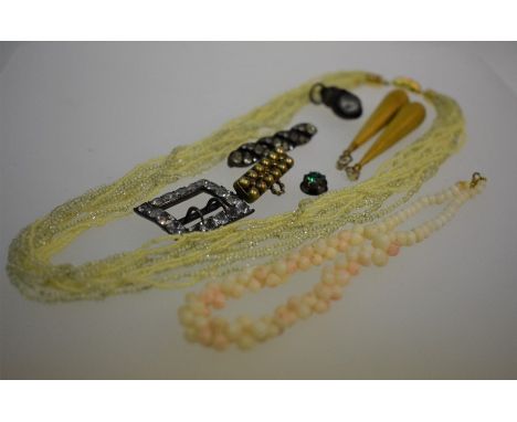
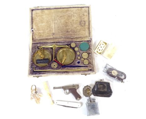
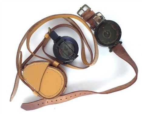
Los 135
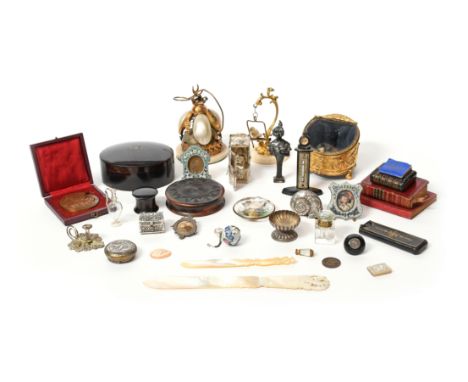
A small collection of vintage jewellery including a pair of Victorian yellow gold drop part earrings with beaded decoration overall, 5.5 cm long, approx 5.3g all in; a pale coral child's necklace, a 'hoof' compass charm, two brooches, paste-set buckle and yellow-glass multi-strand necklace etc
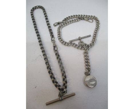
Los 626
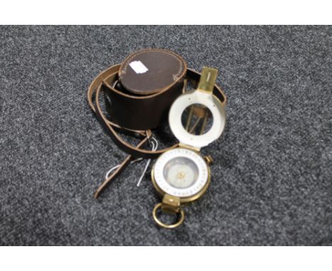
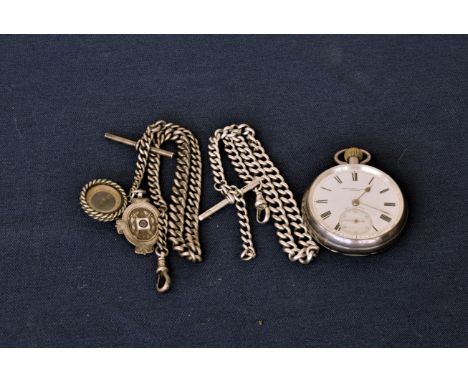
An open faced pocket watch with secondary dial at the six by Pleasance and Harper of Bristol. Silver case made by Rotherham and Sons of Birmingham dated 1900. Also included are two silver watch chains, stamps worn, one with a small compass and a silver pendant, stamped Birmingham, 1908, William Hair Haseler.
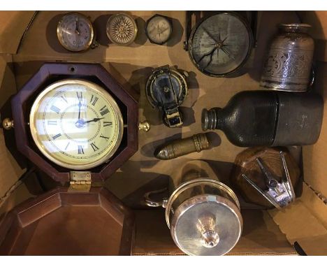
Los 1396
An Oak box with brass plaque inscribed 'A.J Buckley R.E Mesopotamia 1916-17-18' containing a WWI Victory medal and British War medal belonging to 202253 SPR A.J Buckley R.E, a Royal Engineers' cap badge,a photograph of A.J Buckley and a compass. Also belonging to the aforementioned is a document from the Inland Water Transport congratulating Lance Corporal A.J Buckley W.R 552953 on his return home, signed by Brigadier-General R.H.W Hughes dated Bas rah 28-1-1919 along with a tag stamped with his name and number. Other items include a WWII Auxillary Fire Service A.F.S. lapel badge stirling silver no.140290 and a tag A.F.S 8112 Buckley A.J., Birmingham, a suede purse containing coins, a Benson & Hedges cigarette tin covered in red leather, a gentleman's leather wallet, a trinket box with a carving of "Muckross Abbey" and a white metal plaque coat of arms.
Los 278
AN 18TH CENTURY MALACCA POMANDER WALKING CANE, the metal pique inset ivory handle with pierced top unscrewing to reveal a small compartment, 91cm long together with a late 19th / Early 20th Century malacca walking cane, the bowed ivory handle inset with a compass, and having nickel collar, and ivory ferrule, 88cm long (2)

![Holland. Ortelius (Abraham), Hollandiae Antiquorum Catthorum sedis nova Descriptio, Auctore Iacobo a Daventria, [1588], engra](https://cdn.globalauctionplatform.com/45651768-0840-4e6b-a25a-ab4401107d4e/3c6bab74-9c33-4002-91bf-ab450106e298/468x382.jpg)
Los 122
Holland. Ortelius (Abraham), Hollandiae Antiquorum Catthorum sedis nova Descriptio, Auctore Iacobo a Daventria, [1588], engraved map orientated to the east, contemporary hand colouring, large strapwork cartouche, compass rose and numerous rhumb lines, slight dust soiling, central fold strengthened on verso, 355 x 490 mm, Spanish text on verso (Qty: 1)NOTESMarcel van den Broecke, Ortelius Atlas Maps, 79. 1st state.
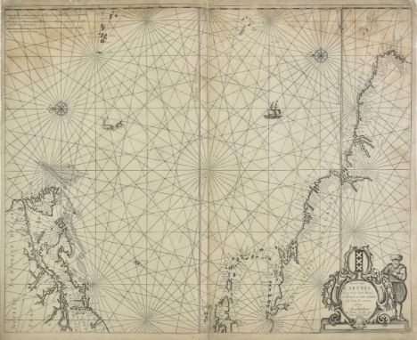
Los 88
Atlantic Ocean. Jacobsz (Theonis aka Lootsman), Pascaert vande Carybes, Nieu Nederlandt, Brazil, de Flaemsche en sout Eylanden en de landen daer ontrent gelegen, Amsterdam, circa 1650, uncoloured engraved sea chart orientated to the east, two compass rose and numerous rhumb lines, some staining, central fold strengthened and repaired on verso, slight worming and areas of paper thinning and abrasion, repaired on verso, margins and corners frayed with slight loss, repaired on verso, 435 x 540 mm (Qty: 1)NOTESBurden 368. Although not in the best of condition this separately issued chart is scarce and important. It shows the Western Atlantic including the West Indies and contiguous parts of the North Eastern United States and Northern South America. The objective of this precursor map was to present in atlas form the most desirable information from the West Indische Paskaert maps of Willem Blaeu. It was much copied throughout the second half of the 17th century.
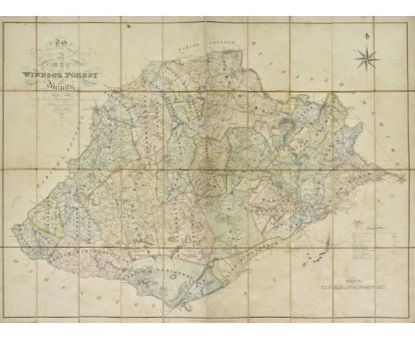
Los 179
Windsor Forest. Walter (H.), To the Kings most Excellent Majesty This Map of Windsor Forest and its Vicinity from actual survey is humbly dedicated..., published August 1st by the Proprietor at Holyport near Maidenhead and E. Mogg London, 1st. edition, 1823, engraved large scale map with contemporary hand colouring, sectionalised and laid on linen, calligraphic cartouche, compass rose and table of explanation, near contemporary manuscript addition of railway lines and a pencil and watercolour plan of Chobham Common showing army encampments, slight staining and some dust and finger soiling, 920 x 1250 mm (Qty: 1)NOTESA rare separately published map of the environs of Windsor Forest from Staines in the West, Bagshot in the South, Twyford in the West and Maidenhead in the North. Walter is not recorded in Worms and Baynton-Williams. Copac lists only two institutional copies (British Library and Oxford University) and Worldcat only one (British Library).
![South West England. Gloucestershire. Saxton (Christopher & Hole G), Glocestriae comitatus olim sedes Dobunorum, [1637], h](https://cdn.globalauctionplatform.com/45651768-0840-4e6b-a25a-ab4401107d4e/70322d97-49e7-4bdc-b62b-ab45010719df/468x382.jpg)
Los 172
South West England. Gloucestershire. Saxton (Christopher & Hole G), Glocestriae comitatus olim sedes Dobunorum, [1637], hand coloured engraved map, large ornate cartouche, mileage scale and compass rose, toned overall, occasional marginal closed tears, 285 x 315 mm, together with Saxton (Christopher & Kip William). Dorcestriae comitatus vulgo Dorset..., circa 1610, hand coloured engraved map, large strapwork cartouche, mileage scale and compass rose, small margins, laid on later card, 275 x 385 mm, with another six county and road maps of Dorset, Cornwall, Somerset and Gloucestershire, including examples by Conder/Hogg, Owen & Bowen, Badeslade & Toms, De La Rochette and Archer, various sizes and condition (Qty: 8)
![* World. Moithey ( Maurille Antoine), Indication Nautique des Principaux Espaces de l'Ocean, Paris, [1787], hand coloured eng](https://cdn.globalauctionplatform.com/45651768-0840-4e6b-a25a-ab4401107d4e/f7ca3048-7d5a-4cde-9513-ab45010724c2/468x382.jpg)
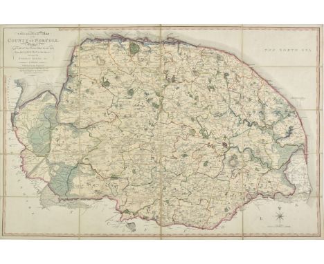
Los 117
Folding County Maps. Milne (Thomas), A Topographical Map of the County of Norfolk reduced by a scale of Two Statute Miles to one Inch from the Large map in six sheets..., published W. Faden, 1803, engraved map with contemporary outline colouring, sectionalised and laid on linen, 590 x 890 mm, contained in a contemporary marbled card slipcase with publisher's printed label to upper cover, case worn and frayed, together with Dix (Thomas). A New Map of the County of Gloucestershire, Divided into Hundreds, published W. Darton, 1830, uncoloured engraved map, sectionalised and laid on linen, circular cartouche, mileage scale, compass rose and vignette of Tewkesbury Church, slight staining, 455 x 365 mm, contained in a contemporary marbled card slipcase with publisher's printed title label to upper cover case worn and frayed, with Cary (John). A New Map of Cornwall Divided into Hundreds exhibiting its Roads, Rivers, Parks &c., 1828, engraved map with bright contemporary outline colouring, sectionalised and laid on linen, oval cartouche, inset map of the Scilly Isles, 485 x 550 mm, marbled endpapers, contained in a contemporary marbled card slipcase with printed title label to upper cover, plus Hall (Sidney). Berkshire [and] Oxfordshire, circa 1850, two engraved maps with contemporary outline colouring, sectionalised and laid on linen, each approximately 195 x 250 mm, contemporary cloth gilt boards, and Walker (J. & C.). Kent [and] Wiltshire, 1835 & 1846 respectively, two engraved maps with contemporary outline colouring, sectionalised and laid on linen, map of Kent stained and dust soiled, each approximately 400 x 330 mm, bound in contemporary cloth boards with printed label to upper cover, with two folding fox hunting maps of Oxfordshire and South West England, various sizes and condition (Qty: 9)
![England and Wales. Hole (William), Englalond Anglia Anglosaxonum Heptarchia, [1637], hand coloured engraved map, large strapw](https://cdn.globalauctionplatform.com/45651768-0840-4e6b-a25a-ab4401107d4e/4c146c46-a76a-47d5-9470-ab450106de1b/468x382.jpg)
Los 115
England and Wales. Hole (William), Englalond Anglia Anglosaxonum Heptarchia, [1637], hand coloured engraved map, large strapwork cartouche and compass rose, 275 x 320 mm, mounted, framed and glazed, together with Danckerts (Theodoris). Novissima et Accuratissima totius Angliae Scotiae et Hiberniae..., Amsterdam, circa 1685, engraved map with contemporary outline colouring, large allegorical cartouche, toned overall, some marginal chipping and staining, paper somewhat brittle, 505 x 585 mm, with another eight maps of England & Wales and the British Isles, including examples by Zatta, Wyld, J & C Walker, Blair, Smith, Archer and Badeslade & Toms, various sizes and condition (Qty: 10)
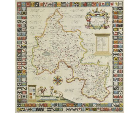
Los 144
Oxfordshire. Plot (Robert), The Map of Oxfordshire..., circa 1677, hand coloured engraved map, decorative cartouche, mileage scale, compass rose and table of explanation, old folds, a few folds repaired on verso, 500 x 480 mm (Qty: 1)NOTESCreated by the first keeper of the Ashmolean Museum of Oxford and decorated with 172 coats of arms of the county's gentry, Oxford colleges, the city and the four county towns. One of the most decorative maps of Oxfordshire ever produced.
-
36562 Los(e)/Seite