

Terra Firma et Novum Regnum Granatense et Popayan Splendid map of the Isthmus of Panama and northwestern South America including most of present day Colombia and part of Venezuela. The map is based on the cartography of Hessel Gerritsz and formed one of the prototypes for South American cartography throughout the rest of the century. Jodocus Hondius engraved the map. After his death, Blaeu obtained the copper plate, added his imprint, and issued the map in a number of atlases. Two cartouches and a pair of compass roses dramatically decorate this map. French text on verso, published between 1638-43. Attractive color on watermarked paper with a hint of toning and light damp stains confined to far blank margins. 15 W x 19.3 H Hondius/Blaeu, 1638
36562 Preisdatenbank Los(e) gefunden, die Ihrer Suche entsprechen
36562 Lose gefunden, die zu Ihrer Suche passen. Abonnieren Sie die Preisdatenbank, um sofortigen Zugriff auf alle Dienstleistungen der Preisdatenbank zu haben.
Preisdatenbank abonnieren- Liste
- Galerie
-
36562 Los(e)/Seite

Tabula Magellanica, qua Tierrae del Fuego, cum Celeberrimis Fretis a F. Magellano et I. Le Maire Detectis Novissima et Accuratissima Descriptio Exhibetur This is one of the most elaborately decorated maps to focus on the tip of South America with the Strait of Magellan and Le Maire Strait. The coastlines are depicted as very mountainous, while the interior is completely without detail. Instead the region is filled with a hunting scene, exotic birds including rheas and penguins, and a quaint scene of village life. The map is further adorned with a pair of compass roses, three sailing ships, and four beautiful cartouches. The key to the map is in a strapwork cartouche held aloft by putti, while the dedication cartouche at right is left blank. The cartouches arrayed across the bottom of the map present a unique distance scale in checkerboard format and the title with a tribe of Fuegian natives, penguins and shells. This is the first state with a blank verso. A dark impression with minor printer`s ink residue and a small, professionally repaired hole in border below penguins, with border expertly replaced in facsimile. 16.1 W x 20.8 H Jansson, Jan 1646

Carta Particolare del Mare di Ethiopia con l`Isola di S. Elena e Parte della Costa d`Affrica Carta VIIII This elegant sea chart is crisply engraved in the sparse Florentine style with superb calligraphy throughout. The map covers the islands in the South Atlantic centering on St. Helena and extending west to Ascension Island. The map extends to include two stretches of the African coastline, including portions of present-day Congo, Angola and Namibia. Sailing ships, a compass rose and a strapwork title cartouche embellish the chart. Short navigational notes are included throughout. This is the first state. Printed on two sheets, joined as issued.Robert Dudley was the first Englishman to produce a sea atlas, Dell Arcano del Mare (Secrets of the Sea). A skilled mathematician and navigator, Dudley was exiled from England and settled in Florence where his atlas was published. He introduced a totally new style for sea charts in the atlas with only lines of latitude and longitude and no rhumb lines. The charts were meticulously compiled from original sources and were both scientific and accurate for the time. This important atlas was the first sea atlas of the whole world; the first to use Mercator`s projection throughout; the earliest to show the prevailing winds, currents and magnetic deviation; and the first to expound the advantages of Great Circle Sailing. In an introductory leaf found in one copy in the British Library, the engraver states that he worked on the plates in seclusion for twelve years in an obscure Tuscan village, using no less than 5,000 pounds of copper for the printing plates. It was only issued in two editions and the maps are rarely seen on the market. A nice dark impression with light printer`s ink residue on bright, watermarked paper. A very fine example with just a touch of marginal soiling. 19.3 W x 30.3 H Dudley, Robert (Sir) 1646

Terra Nova, ac Maris Tractus circa Novam Franciam, Angliam, Belgium, Venezuelam Novam Andalusiam, Guianam et Brasiliam - Terra Neuf, en de Custen van Nieu Vranckryck, Nieu Engeland, Nieu Nederland, Nieu Andalusia, Guiana en Venezuela Magnificent sea chart of the western Atlantic Ocean showing the coastlines of North America from Cape Charles, Maryland to Newfoundland, and the West Indies to the northern coast of Brazil. The chart is based on that of Theunis Jacobsz, circa 1650, with few changes except for an improved (although still rudimentary) depiction of the Chesapeake Bay. Oriented by two compass roses with north to the left; the Azores and Cape Verde Islands are at the top of the map. It is richly decorated with two large cartouches with the title in Latin and Dutch. The central cartouche is surrounded by Mercury, a native riding an alligator, mermen and sea monsters. The corner cartouche with Dutch title features figures of explorers, natives, and exotic animals, including an armadillo. In the sea are sailing ships, including a raging sea battle, rhumb lines and two compass roses. This is the first state, with page 22 at top right.First published circa 1675, de Wit`s sea atlas, Orbis Maritimus ofte Zee Atlas, contained 27 charts from the North Pole to North and South America. The charts all appear to have been engraved by Romain de Hooghe and are splendid examples of Dutch marine works. The atlas was reprinted with amendments by Louis Renard in 1715, by Reinier and Josua Ottens in 1739 and 1745, and finally by the widow of van Keulen in 1802. A nice, dark impression with a few small spots of printer`s ink residue. There are professional repairs to a centerfold separation that enters 1"" into map at bottom, a 1"" separation along the upper centerfold only visible when held to light, a small hole and tear in Brazil, and a number of small tears and chips in blank margins. 19 W x 22.2 H Wit, Frederick de 1675

Mappa Aestivarum Insularum, Alias Barmudas Dictarum, ad Ostia Mexicani Aestuary Jacetium... A striking map based on the famous survey by Richard Norwood of the Bermuda Company, also known as the Somers Isles Company, in 1618. The map shows the division into the original Tribes, which were a short-lived name for what became administrative parishes, and were names of major shareholders in the company. Also shown are the various landowners, with their names in a table below the map. There are many tiny houses shown on the map, locating settlements, as well as minute cannons marking the defensible points. The map is superimposed over a chart of the Atlantic with the coastlines of Britain, North America and Hispaniola showing the location of Bermuda. Decorated with an exquisite strapwork cartouche, a coat of arms, a medallion and a compass rose. Jansson reissued Hondius` plate with his imprint between 1647 and 1666. Spanish text on verso, published between 1653-66. A nice impression with wide margins and professionally repaired centerfold separations that enter into map 1"" at top and 2"" at bottom. There is minor soiling and a faint damp stain at left. 15.5 W x 20.4 H Hondius/Jansson, 1653

Islanda This wonderful little map of Iceland shows the island prior to when any actual surveys were completed. It reflects very sketchy knowledge of the island, which is shown surrounded by many smaller islands. The minutely engraved map features delightful depictions of topography and elaborate cities. Mount Hecla is shown as a flaming mountain and named Mons Helafiel. Several icebergs are shown floating off the coast. The map is oriented by a simple compass and adorned with a deftly engraved cartouche. Engraved by Girolamo Porro and printed on a full sheet (8.3 x 11.6"") of Italian text. A dark impression with marginal soiling and foxing, well away from image. 4.1 W x 5.8 H Porcacchi, Tomaso 1586

Tabula Islandiae Auctore Georgio Carolo Flandro This handsome copper engraved map of Iceland was based on information from a Dutch navigator named Joris Carolus in about 1620. The map shows the influence of both versions of Bishop Gudbrandur`s previous maps, a coastline resembling the Ortelius version, and Mercator`s selection and spelling of many place names. The island`s topography is dominated by huge mountains and volcanoes and its shoreline is a rugged labyrinth of fiords. It is richly embellished with title and distance scale cartouches, compass roses, rhumb lines, a sailing ship and two sea monsters. The cartouche features two winged sprites, an important symbol in Icelandic and Norse mythology. Along with elves and dwarves, sprites were magical beings who aided the gods. The map was first issued by Jodocus Hondius and then re-issued by Willem Blaeu with his imprint. It became the prototype for the mapping of Iceland and its influence did not wane until the mid-18th century. French text on verso, published between 1643-50. A fine impression with original color that has been partially refreshed and minor damp stains in the bottom blank margin. 15 W x 19.5 H Hondius/Blaeu, 1644
![[Lot of 3] Groenland [and] Novae Zemlae Delineatio [and] Delineatio Freti Vaigats This matched set of 3 miniature maps are f](http://lot-images.atgmedia.com/SR/36385/2906594/411-20145813631_468x382.jpg)
[Lot of 3] Groenland [and] Novae Zemlae Delineatio [and] Delineatio Freti Vaigats This matched set of 3 miniature maps are from Bertius` geographical treatise. Each map is beautifully engraved with a strapwork title cartouche and fully engraved seas. The majority of the maps for Bertius` geographical treatise were engraved by Jodocus Hondius Jr. after Mercator. French text on verso. Size varies slightly.A. Groenland. This handsome miniature map is one of the first maps to focus on Greenland. The island is shown as a narrow island with a central mountain range. Across the Fretum Davis is C. Bedford. Iceland is also shown with an erupting volcano.B. Novae Zemlae Delineatio. This charming miniature map shows the parts of Novaya Zemlya that had been discovered by western Europeans during their search for a northern passage to Asia. The first visit was by Hugh Willoughby in 1553. Then in 1596, Willem Barents rounded the north point of Novaya Zemlya, and wintered on the east coast near the northern tip. The map shows the western coast and northern tip of Novaya Zemlya according to Barent`s reports, and is decorated with two sailing ships and a raft of penguins in the sea, with a decorative title cartouche and compass rose.C. Delineatio Freti Vaigats. This miniature map shows the straits between mainland Russia and Vaygach Island, an area that was discovered by western Europeans during their search for a northern passage to Asia. The first visit was by Hugh Willoughby in 1553. Then in 1596, Willem Barents rounded the north point of Novaya Zemlya, and wintered on the east coast near the northern tip. At the time Vaygach Island was thought to be a part of Novaya Zemlya. The map is decorated with a sailing ship, compass rose, spouting whale, and a nice title cartouche. Very light toning and marginal soiling. 3.8 W x 5.3 H Hondius/Bertius, 1616

Pascaart Vant Canaal Tusschen Engelant en Vrancryck Tabula Hydographica Freti seu Canalis Rare and elegantly engraved chart of the British Isles and English Channel, based on a chart by Anthony Jacobsz from 1644. Place names are confined to the coastlines, and soundings, rocks, shoals, and other navigational information are included. Two decorative compass roses orient north to the right. The title cartouche is flanked by two ancient Britons, who stand upon sea monsters and hold the royal coat of arms. This is the first state, prior to the names of the seas being added. French text on verso. A good impression with minor show-through of text on verso, a couple of tiny spots, and a small hole off the southwestern coast of Wales that has been professionally infilled. 17.25 W x 22 H Jansson, Jan 1650

Map of the County of Middlesex, from an Actual Survey Made in the Years 1819 & 1820 This large and decorative map of Middlesex was published by the famous Greenwood firm. It depicts the region from London west to Uxbridge and north to Waltham Abbey. Large vignettes of Westminster Abbey and St. Paul`s Cathedral are illustrated in the lower portion of the sheet with a large compass rose above the map image. On watermarked paper with moderate soiling, two extraneous vertical creases to the left of the centerfold, and an edge tear confined to the right blank margin. 21.2 W x 25.6 H Greenwood Firm, 1829

To the Honourable Sr. Ralph Delaval Kt. Vice Admirall of the Red This Is Most Humbly Dedicated & Presented by Capt. Greenvile Collins Hydrographer to the King This elegant chart of the southeast coast of England spans from the Firth of Forth (here called Edinbrough Frith) down to Kent, and extends across the North Sea to show part of the coast of the Netherlands. There is little to no inland detail, but counties, towns, and cities, including a prominent London, are identified along the coasts. The chart shows good navigational detail, with soundings, fishing banks, shoals, and rocks depicted. A compass rose at the center of the chart orients north to the right and a coat-of-arms appears in England. Neptune and the allegorical female representation of Earth flank the decorative title/dedication cartouche.In 1681 Capt. Greenville Collins (fl.1669-1694) an officer in the Royal Navy was appointed by the Admiralty to make a complete survey of the coasts of Great Britain. Prior to this date the charts used by English mariners were copies of Dutch charts that had many inaccuracies. The task of surveying the entire coasts was formidable and took about 7 years, at the end of which only 46 surveys were finally used in an atlas titled ""Great Britain`s Coasting-Pilot Being a New and Exact Survey of the Sea-Coast of England,"" which was first published in 1693. There is light soiling, a few minute worm holes that are only visible when held up to light, and scattered foxing mostly concentrated in the blank margins. 17.6 W x 22.1 H Collins, Capt. Greenvile 1693

Scotia This is one of the earliest printed maps of Scotland, with north oriented to the right of the page. The map is adorned with sailing ships, sea monsters, a compass rose, a stippled sea, and a title cartouche flanked by putti. Engraved by Girolamo Porro and printed on a full sheet (8.3 x 11.6"") of Italian text. Minor soiling in the blank margins. 4.1 W x 5.6 H Porcacchi, Tomaso 1586

Irlanda A charming small map of Ireland with north oriented to the right. The shape and geography of the country is quite rudimentary, with cities focused primarily along the coastline. The map is adorned with fantastical sea monsters, a compass rose, and a decorative title cartouche. Engraved by Girolamo Porro and printed on a full sheet (8.3 x 11.6"") of Italian text. On watermarked paper with minor show-through of engraving on verso. An ink notation and some scattered foxing appear along the sheet`s edges, well away from image. 4.1 W x 5.6 H Porcacchi, Tomaso 1586

A Plan of the River Lagon, and of the Intended Navigable Canal from Belfast to Loughneagh... This appealing map centers on the River Lagan and stretches from Lough Neagh to just northeast of Belfast. Various towns and cities, mills, bridges, and roads are shown. A chart at bottom right indicates the distance between various destinations in the area depicted. A compass rose orients the map with the north to the upper right hand corner. Issued folding with light offsetting. 6.8 W x 12.4 H Bowen, Emanuel 1778

This Chart of Kingsale Harbour Is Humbly Dedicated and Presented to the Right Honble Sr. Robert Southwell... This handsome chart focuses on a portion of County Cork in southwest Ireland, where the River Bandon meets the Bay of Old Head. The fishing village of Kinsale is prominently featured as a dense cluster of buildings in the shadow of Compass Hill. Across the River Bandon is an Old Fort, with a new, larger fort depicted down the river, past Summers Cove. Various other coves are located along the coast, as are sites of interest such as the lighthouse at Old Head, Fishing Pallace, Ruines of a Forte, and Lord Courcyes House. Within the water there are numerous soundings and hazards, as well as a compass rose capped with a fleur-de-lis that radiates rhumb lines and orients north to the lower right corner. Cannons and flags jut from an elaborate cartouche flanked by putti that encloses a dedication to Sir Robert Southwell. Engraved by J. Harris. In 1681 Capt. Greenville Collins (fl.1669-1694) an officer in the Royal Navy was appointed by the Admiralty to make a complete survey of the coasts of Great Britain. Prior to this date the charts used by English mariners were copies of Dutch charts that had many inaccuracies. The task of surveying the entire coasts was formidable and took about 7 years, at the end of which only 46 surveys were finally used in an atlas titled ""Great Britain`s Coasting-Pilot Being a New and Exact Survey of the Sea-Coast of England,"" which was first published in 1693. Nice impression and color with light soiling and a printer`s crease adjacent to the centerfold. There are remnants of hinge tape in the blank margins on recto. 17.6 W x 22.3 H Collins, Capt. Greenvile 1693
![[Lot of 2] Hollanda [and] Isole Selandie Two very fine copper-engraved charts in the Italian style with fully stippled seas,](http://lot-images.atgmedia.com/SR/36385/2906594/477-20145813835_468x382.jpg)
[Lot of 2] Hollanda [and] Isole Selandie Two very fine copper-engraved charts in the Italian style with fully stippled seas, depicting the Netherlands with the islands of Zeeland, and part of Flanders to the south. Cities are illustrated with miniature castles and include Rotterdam, Breda, Polder, and Brussels. Each map is adorned with a strapwork title cartouche and a compass rose. Engraved by Girolamo Porro and printed on full sheets (7 x 10.3"") of Italian text. Lovely color and minor soiling with manuscript writing in blank margins. Hollanda also has a couple of small manuscript marks in the map image. 4 W x 5.5 H Porcacchi, Tomaso 1590

A Correct Chart of the Bay of Biscay This lovely small chart of the Bay of Biscay features soundings as well as notes indicating the type of sand or the presence of rocks at various points on the ocean floor. A note off the northern coast of Spain states, ""The depth of Water on the N. Coast of Spain is from 150 to 200 Fathoms generally Coral and Rocky Ground but even near the Land there is often no Ground at that Depth."" There is good detail along the French and Spanish coastlines. A compass rose capped with a fleur-de-lis radiates rhumb lines at the map`s center. This chart was engraved by Rollinson for Rev. John Malham (1747-1821), a writer and teacher of navigation, for the first American edition of Malham`s The Naval Gazetteer; or, Seaman`s Complete Guide. Minor soiling with a tiny repaired hole in an unengraved area at top right. 9.3 W x 7.3 H Malham, John (Rev.) 1797
![[Lot of 2] Les Environs de la Rochelle et de l`Isle de Re [and] L`Isle de Narmoustier A. Les Environs de la Rochelle et de l](http://lot-images.atgmedia.com/SR/36385/2906594/492-2014581397_468x382.jpg)
[Lot of 2] Les Environs de la Rochelle et de l`Isle de Re [and] L`Isle de Narmoustier A. Les Environs de la Rochelle et de l`Isle de Re, by Nicolas de Fer, from L`Atlas Curieux, dated 1715 (12.9 x 8.9""). Ref: Pastoureau, FER ID. This lovely chart shows the French seaport La Rochelle, its surroundings, and the Ile de Re in the Bay of Biscay. Several towns and cities are marked by small depictions of fortresses or structures. Salt evaporation ponds appear on the outskirts of La Rochelle, and various ports, canals, marshlands, and rock formations and flats are noted. A compass rose topped with a fleur-de-lis adorns the center of the chart. With an accompanying sheet of text titled Description de la Rochelle et de l`Isle de Re. Condition: On watermarked paper with a few small spots. (A)B. L`Isle de Narmoustier, by Nicholas Tassin, from Cartes Generales des Provinces de France et d`Espagne..., circa 1633 (5.9 x 4.1""). Ref: Pastoureau, TASSIN III [28]. This small decorative map provides a bird`s-eye view of Noirmoutier-en-l`Ile in the Bay of Biscay. Small depictions of plots of land, a windmill, churches, and other structures appear all over the island. Also included are a decorative title cartouche, a compass rose topped with a fleur-de-lis, and several sailing ships. Condition: The sheet has been remargined at top and there is a 3"" diagonal tear running from the neatline at top to the center of the island that has been closed on verso with archival materials. A notation in pink ink appears in the bottom blank margin. (B+) See description above. 1633-1715

A Plan of the City of Paris This detailed plan of Paris identifies major streets and 78 notable locations in the City of Light, including Place de la Concorde (here called Lewis the XV. Place), Tuileries Palace, Notre Dame (Our Lady), and the Louvre (The Old Louver). A small, simple compass rose capped with a fleur-de-lis in the Seine orients the north to the top left of the sheet. The decorative title cartouche includes the sun, a globe, a bust, a couple barrels, and other items that symbolize the intellectual and commercial strength of the city. There are a few faint spots in the image and the sheet has been remargined at left with old paper. The title cartouche has been hand colored. 9 W x 10.3 H Stockdale, John 1800

Hispaniae Nova et Exacta Descriptio This very rare map of Spain and Portugal was published only in the first edition of Paulus Merula`s Cosmographiae Generalis, which included 5 larger maps engraved by Johannes and Baptista van Doetecum and 38 maps from Petrus Bertius` Tabularum Geographicarum. The map extends to the Balearic Islands and the northern tip of Africa, and is filled with details of towns, rivers, mountains, and political boundaries. Elegantly engraved by Baptista van Doetecum, the map is embellished with a compass rose, sailing ship, and delicately patterned sea. The strapwork title cartouche encompasses the distance scale and is topped with the Royal coat of arms of Spain, ruled by the House of Habsburg.Merula, a Dutch jurist, was appointed to the chair of history at the University of Leyden in 1592. In addition to this geography he also published folio editions, wrote many treatises on laws and history, and is also known for his geological studies. A fine impression with attractive color on watermarked paper. Issued folding, now pressed, with minor offsetting and a binding trim at left that has been professionally repaired. 9.2 W x 12.8 H Merula, Paulus G. 1605

Valentia Regnum; Contestani, Ptol. Edentani, Plin. A handsome map of Valencia detailing the area from the Cenia River to St. Gines and inland to Murcia and Teruel. The map has numerous place names with pictorial depictions of cities and towns. The sea is filled with galleons, a sea monster and a fine compass rose. The decorative cartouche is topped with the coat of arms of the region, featuring a miniature view of the city of Valencia. French text on verso. A fine impression with generous margins, and original outline color in map with later coloring in cartouche and decorative elements. There are faint damp stains in corners of sheet, a couple of creases just above title cartouche, and a tear confined to bottom blank margin that has been closed on verso with archival tape. Otherwise a bright, clean example. 15.1 W x 19.4 H Blaeu, Willem 1635

Rugia Insula ac Ducatus Accuratissime Descripta ab E. Lubino... Very detailed and attractive chart of the island of Rugen in the Baltic Sea from a map by Eihard Lubin. Many place names are located on this informative chart. It is ornamented with a decorative strapwork cartouche topped with a crest and lions, an elaborate compass rose, and a ship and a sea monster in the sea. The map is flanked with 30 named coats-of-arms and is a beautiful example of Blaeu`s work. French text on verso, published between 1643-50. A nice impression with original color that has been partially refreshed and a few spots of offsetting. There are faint damp stains and worm tracks confined to the bottom blank margin. 15.1 W x 19.7 H Blaeu, Willem 1643

A Plan of the City of Geneva Beautifully detailed plan of the fortress situated where the Rhone River exits Lake Geneva. A key identifies 22 notable locations on the plan. A compass rose orients north to the top left corner. Adorned with a decorative title cartouche featuring a grape vine and a hunter with his dogs. Slightly toned with a few faint spots. There is a small tear in the bottom right corner of the sheet that has been closed on verso with archival tape, well away from the image. The title cartouche has been hand colored. 6.8 W x 9.5 H Stockdale, John 1800

A Plan of the City of Vienna This charming small plan of Vienna extends to show the Danube River beyond the outskirts of the city. A key at left identifies 45 places of note in the city, including several churches and convents. In the Danube, a compass rose capped with a fleur-de-lis orients the north to the top right of the sheet. An ornate title cartouche appears in the top right corner. There are a few small spots, mostly outside the neatline, and minor toning in the blank margins. 6.9 W x 9.8 H Stockdale, John 1800

Maiorica This graphic little map is one of the earliest separate maps of Majorca, first issued in 1572. The island is depicted with its major cities and is surrounded with a variety of fantastic sea monsters and adorned with a decorative title cartouche. A compass rose orients the map with southeast at top. Engraved by Girolamo Porro and printed on a full sheet (8.2 x 11.6"") of Italian text. There is some scattered foxing primarily confined to the blank margins. 4.1 W x 5.7 H Porcacchi, Tomaso 1586

Nieuwe Kaart van `t Eiland Maltha met Gozo en Comino... Handsome, large map of the Maltese Islands with superb detail of the topography, roads, villages and fortifications. The important forts, harbors and Valetta are particularly well illustrated with a key locating important sites. A nice compass rose orients north in the lower right corner. Issued folding with a hint of offsetting and a professionally replaced binding trim at top right. 11.1 W x 18.2 H Tirion, Isaac 1761

Cyprus Insula This superb map of the island of Cyprus is geographically based on the earlier work of Ortelius. But it is the beautiful composition that makes it one of the most desirable maps of the island; many of its decorative features were copied by other cartographers. At top are two coats of arms; at center the arms of the House of the Lusignans, and at left the Turkish arms. The map is attractively arrayed with compass roses, sailing ships, and rhumb lines. The large cartouche at bottom right shows Aphrodite being drawn across the sea in a seashell chariot pulled by a pair of swans, while Cupid pierces her heart with an arrow. German text on verso. Nice impression and original color. Trimmed close to the neatline at left and right with a chip in bottom right corner replaced with old paper, with a small portion of neatline replaced in facsimile. There is light show-through of text on verso. 15 W x 19.9 H Blaeu, Willem 1641

Tabula Geographica, in Qua Omnes Regiones, Urbes, Oppida, et Loca Describuntur, quorum mentio sit in Actis et Epistolis Apostolorum, et Apaocalypsi This superb, graphic map of the eastern Mediterranean, from Rome to Babylon, depicts the spread of Christianity as reported in the Acts of the Apostles. This is the final map of the standard set of five Holy Land maps normally found in Dutch Bibles. The map is surrounded by fifteen Biblical vignettes including the apostles receiving heavenly inspiration, and the events of the Apocalypse as in the book of Revelations. The map includes a small inset of the whole Mediterranean region and is further decorated with a compass rose, sailing ship and strapwork distance scale. This is the second state with Plancius` name in the cartouche replaced by D.R.M. Mathes. Dutch text on verso, from a Dutch Bible published by Cloppenburg. This is the second series of Dutch bible maps by Petrus Plancius, first published in 1604 by Johannes Cloppenburg. The first series consisted of a world map and 4 small maps of the Holy Land and Middle East, engraved by Johannes van Deutecum and his two sons, Johannes and Baptista. After Johannes van Deutecum (the younger) published a new set of maps in 1595, Plancius realized that his own maps required updating. He commissioned Baptista van Deutecum to engrave the second series, who also enlisted the assistance of engravers Daniel van Bremden and Pieter Bast. Plancius` second series retained the same world map and 6 larger, re-engraved maps of the Holy Land and Middle East. The purpose of the maps was to help explain the biblical texts, but Plancius decided to take the maps one step further by adding 15 biblical vignettes surrounding each map, thereby transforming each map into a work of art. Issued folding, now pressed with a 3"" tear adjacent to centerfold near bottom that has been professionally repaired. Remargined at both sides to accommodate framing. 11.3 W x 19.3 H Plancius/Cloppenburg, 1643

De Beschryvingh van de Reysen Pauli en van de andere Apostelen This beautiful map of the eastern Mediterranean region details the travels of Apostle Paul. It is richly decorated with scenes from St. Paul`s travels in vignettes along the top and bottom and numerous sailing ships and a compass rose in the sea. This is the first state. Dutch text on verso. Issued folding, now pressed with one extraneous horizontal crease, a tiny hole at the center, and a few minor printer`s creases. There are some minute worm holes only visible when held to light. 13.8 W x 18 H Stoopendaal, Bastiaan 1686

Situs Terrae Promissionis SS Bibliorum Intelligentiam Exacte Aperiens Adrichom`s stunning map of the Holy Land was based on numerous sources, including Peter Laicksteen and Christian Sgrooten, Tilleman Stella, Jacob Ziegler, Sebastian Munster, Gerard Mercator, Buchard of Mt. Sion, and even Josephus, Jerome and Ptolemy. This map became immediately popular with leading cartographers such as Jan Jansson and Nicholas Visscher, who used it as the basis for their own maps of the Holy Land. With north oriented to the bottom left, the map extends from the Nile delta to Sidon and is divided into the twelve tribes. There is no bend where Palestine meets Egypt, and the Kishon River erroneously connects the Sea of Galilee with the Mediterranean. The map is finely engraved with minute detail and depicts numerous biblical scenes including the Exodus, Jonah and the Whale, the wandering of the Children of Israel, and several battle scenes. Four burning cities are shown in the Dead Sea: Sodoma, Gomorra, Seboim, and Adama. Sailing ships, sea monsters, Adrichom`s coat of arms, and a compass rose complete the composition. On two sheets, joined as issued.The Theatrum Terrae Sanctae was an atlas and history of the Holy Land and was Adrichom`s most important and famous work. Born in Delft, Christian Kruik van Adrichem, or Christianus Crucius Adrichomius, was a Catholic priest and theologian. Adrichom worked for thirty years on his three-part history of the Holy Land, and only succeeded in publishing the first part, Urbis Hierosolyma Depicta, during his lifetime. The remaining two parts were published posthumously by Georg Braun in 1590, with subsequent editions in 1593, 1600, 1613, 1628, and 1682. The Theatrum Terrae Sanctae contained 12 maps and plans: one of the Holy Land, nine of territories of the Tribes of Israel, one of the Exodus, and a town plan of Jerusalem. A nice impression with attractive color. Issued folding with light creasing along the joint. 13.8 W x 39.3 H Adrichom, Christian van 1682

Het Beloofde Landt Canaan door Wandelt van Onsen Salichmaecker Iesu Christo, Nessens Syne Apostelen Graphic map of Israel filled with biblical scenes. A compass rose orients the map with north in the top right corner. The large decorative title cartouche at bottom is flanked with the four evangelists and vignettes depicting the life of Christ, including his birth, crucifixion and resurrection. At top, putti hold banners with the key to the map and scale of miles, and tiny ships and the track of Apostle Paul are shown in the sea. Published by Hendrik and Jacob Keur in a Dutch Bible, with Dutch text on verso. A fine impression, issued folding, now pressed, with minor printer`s ink residue at top center and a few minor fold separations confined to blank margins. 14 W x 18.3 H Stoopendaal, Bastiaan 1686

Asiae Nova Delineatio Superb large map of the whole of Asia and the East Indies. The discoveries of Tasman, Janszoon, and Cartensz are reflected in Australia and New Guinea. The delineation of Japan follows that of Mercator-Hondius, but also includes the discoveries of De Vries in Yedso. A long stretch of desert identified as the Xamo (Mandarin for sandy desert) appears in the western part of China. The map is ornamented with various types of sailing vessels, a compass rose, and animals on the African continent. There is a splendid title cartouche surrounded by mermaids and the angel of Fame, as well as a dedication cartouche featuring the coat of arms of D. Henrico Spiegel, Senator of Amsterdam. A crisp impression with original color, minor toning, light soiling, and some short edge tears and chips in the blank margins, the longest of which have been closed with archival tape. There is a 5.5"" centerfold separation at bottom, and another at top that just enters the neatline both of which have been archivally repaired. A damp stain along the top edge of sheet just enters into map image. 17.1 W x 21.4 H Visscher, Nicolas 1670

Karte von den Eylanden in der Mundung des Flusses Canton nach den Wahrnehmungen der Schiffahrer This is the German version of this map centered on the mouth of the Pearl River, here called the Canton. The map features nice detail of the islands off the coast of Southeastern China including part of Macao. There are numerous soundings noted as well as a large compass rose, fleur-de-lis, rhumb lines and decorative title cartouche with distance scale. Issued folding. 8.1 W x 12.5 H Bellin, Jacques Nicolas 1754

Plan du Port et de la Ville de Nangasaki Bellin`s smaller version of this great plan of Nagasaki. The map is oriented to the southwest with a bold compass rose. The map locates the principal points of interest and major buildings. The Desima is central to the map. This artificial island in the bay of Nagasaki was where the VOC (Dutch East India Company) were allowed to trade with the representatives of the Shogun in Edo. Locates a large Temple complex at the end of the bay. The rococo-style title cartouche incorporates the key to locations. Engraved by Dheulland. A fine impression on a clean, bright, watermarked sheet. Issued folding. 7.8 W x 13.4 H Bellin, Jacques Nicolas 1763

A New Chart of the Straits of Sunda. Banka, Gaspar and Billiton The Java Sea is the focus of this large striking chart. Several Indonesian islands are shown, including parts of Java in the south, Sumatra in the west, and Borneo in the northeastern corner of the sheet. There is little information inland, but notable locations and topographical features are detailed along the coasts. Numerous soundings, rocks, shoals, and anchorages appear in the water. Two prominent compass roses topped with fleurs-de-lis radiate rhumb lines and orient the north to the right. Four small views around the title illustrate how various mountains and hills appear from a vantage in the water. Engraved by J. Stephenson. Issued folding on a sturdy sheet with a few faint spots and short edge tears and separations barely entering the neatline that have been professionally repaired on verso. 25.3 W x 36.7 H Heather, William 1803

Taprobana Charming map of the island nation of Sri Lanka with north oriented to the right of the map. Only a bit of the Indian mainland is shown and it is incorrectly depicted to the east of the island. Strapwork title cartouche, an unusual compass rose, and a stipple engraved sea combine to make this a very attractive map. Engraved by Girolamo Porro and printed on a full sheet (8.3 x 11.6"") of Italian text. A fine impression with light scattered foxing concentrated along the sheet`s edges, well away from image. 4.1 W x 5.7 H Porcacchi, Tomaso 1586

Africae Nova Descriptio This is one of the most decorative seventeenth century maps of the African continent and a superb example of the Dutch carte-a-figures style. The map is surrounded on three sides with vignettes of native peoples and nine principal cities. The Nile is shown according to Ptolemy with its sources arising in the lakes Zaire and Zaflan, the fictitious Lake Sachaf of Laurent Fries appears, as well as the R. de Spirito Santo. The map is further embellished with numerous ships, sea monsters (including a great seahorse), a compass rose and exotic animals wandering all over the continent. This is the second state of the map. Latin text on verso. Original color, with some cracks caused by the oxidation of the green pigment, all of which have been archivally repaired on verso. A centerfold separation that enters 3"" into map at bottom has been professionally repaired. 16.1 W x 21.7 H Blaeu, Willem 1631

Typus Orarum Maritimarum Guineae, Manicongo, & Angolae ultra Promontorium Bonae Spei This is one of the most richly ornamented maps in early cartography, superbly engraved in the Flemish style by Arnold Florent van Langren. The cartouche contains a description of the region in both Latin and Dutch that credits the source as ""the very best Indian maps"" - referring to maps that Linschoten had access to when he was Secretary to the Portuguese Archbishop of Goa in India. The map covers the southwestern coast of Africa from the Gulf of Guinea to just beyond the Cape of Good Hope with excellent detail along the coastline. The fictitious cities of Vigiti Magna and Monomotapa are located and most place names and geographical features have Portuguese nomenclature. The mainland is embellished with snakes, an elephant, a rhinoceros, a lion and a pair of sirens in Lake Zaire. The balance of the sheet is filled with fabulous cartouches, the Portuguese arms, elaborate compass roses, sailing ships and a sea monster. The large bottom cartouche encloses views of Ascension and St. Helena Islands; important refueling ports in the route around Africa. Issued folding, now pressed on watermarked paper with a couple of insignificant spots. Expertly remargined at left, right and bottom with old paper. 15.5 W x 21 H Linschoten/Langren, 1596


A silver gilt cased keywind open-faced gentleman`s pocket watch, the enamelled dial with black Roman numerals and subsidiary seconds, Birmingham 1885, a silver gilt bar and oval link watch Albert chain, fitted with a swivel, T-bar and a 9ct gold Masonic square and compass pendant fob, Birmingham 1915, a silver cased keyless wind open-faced pocket watch, import mark London 1915, and an Ingersol Crown base metal cased keyless wind open-faced pocket watch.


A Victorian silver novelty vinaigrette, by Thomas Johnson, London 1874, modelled as a ship's wheel, the hobnail cut centre revealing a scroll pierced gilt grille, 4cm diameter CONDITION REPORT: Lacking back to central boss - possibly originally a compass. Please enquire for a full condition report.

A Victorian banded agate and enamel gold brooch/pendant, of circular shield form. A circular cabochon banded agate, rub set with a fine twisted wire frame, to a ridged outer hoop with lines of twisted wire decoration, and applied fleur-de-lys at the compass points, with black enamel and hand engraved tips. Glazed locket verso, concealed pendant bale and brooch pin. Tested as approximately 15ct gold CONDITION REPORT: Losses of enamel to the fleur-de-lys. Tarnish to the back around the brooch fittings. Some scratches to the back.

An 18ct gold, diamond, sapphire and emerald cluster ring, with a brilliant cut diamond, claw set to the centre. An oval mixed cut sapphire, claw set at each compass point, with circular mixed cut emerald points between, and an outer row of eight cut diamonds, claw set in leaf shapes. White gold setting, yellow wire basket, chenier shoulders and plain shank, London 1975. Finger size L

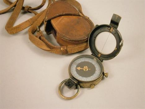
A World War I military issue Verner's pattern mk VI bearing compass, the mother of pearl dial with contemporary paper label modification (for visibility), by J. Hicks of London, no. 6250, 1913, in stitched leather case with strap, to/w a pair of x8 lacquered brass binoculars, in leather case (2)

A collection of WW1 ephemera, including Winston Churchill 'The Great War' (vol. 15 lacking), Bruce Bairnsfather 'The Bystander Fragments from all the Fronts', a Trench map, map showing the Line, Spring 1917, a book of poetry 'The Undying Splendour' by J. W. Streets, a steel compass and a French book of postcards of bombed towns


-
36562 Los(e)/Seite