36562 Preisdatenbank Los(e) gefunden, die Ihrer Suche entsprechen
36562 Lose gefunden, die zu Ihrer Suche passen. Abonnieren Sie die Preisdatenbank, um sofortigen Zugriff auf alle Dienstleistungen der Preisdatenbank zu haben.
Preisdatenbank abonnieren- Liste
- Galerie
-
36562 Los(e)/Seite

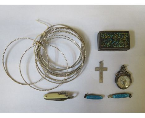
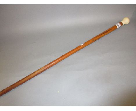
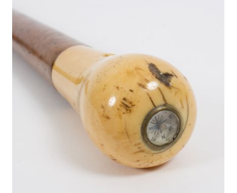
Los 47
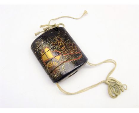
Japanese lacquer four-case Inro, Edo period, 18th Century, decorated with figures by a cart and with stylised lions to the reverse in gold and red, the base inset with a compass 7 x 6cms- Soame Jenyns Collection Condition Report & Further Details This lot comes from the collection of Soame Jenyns (1904- 1976) and is being sold by order of the executors of his younger son, the late John Jenyns. Soame Jenyns was Assistant Keeper of Oriental Antiquities at The British Museum from 1931-1967. He published several books including: "A Background to Chinese Painting" published 1935, "Chinese Archaic Jades in the British Museum" 1951, "Ming Pottery & Porcelain" 1953 etc.Open and closes easily, possibly a little loose. Small chip to one section, possibly caused from opening. Slightly different colour or past inlay on carriage wheel - possibly some replacement.
Los 1403
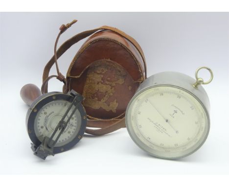
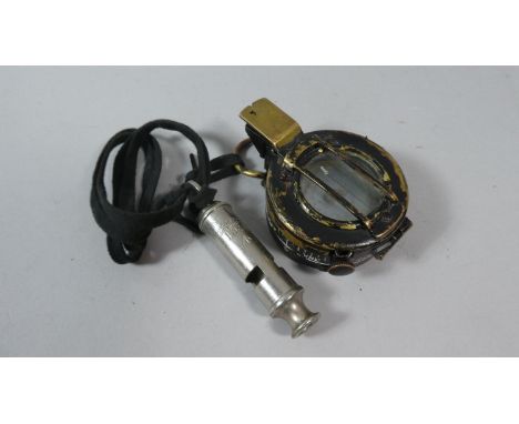
SIR W. THOMPSON'S AZIMUTH MIRROR, by Henry Hughes & Son, Marine Opticians and Manufacturers, London, in original wooden box Note: Used with a compass, this device enables the operator to take celestial and terrestrial bearings. By means of a mirror and a lens, the azimuth mirror allows both the compass's direction and the object in question to be seen at the same time and in the same direction.


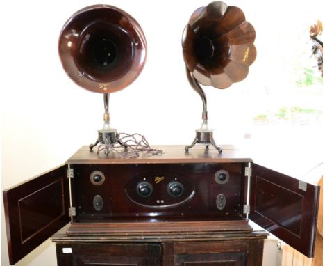
Los 2061
Burndept 'The Ethodyne' Seven Valve Super-Heterodyne Receiver consisting of Model No.1587 Receiver with two tuning dials, volume, Low/High power selector, Reaction Increase adjuster and 3-way frequency selector in mahogany cabinet with compass to top 32x12 1/2x15'', 81x32x38cm; two diamond Frame Aerials: No.976 (1000-2000 meters) and No.975 (250-550 meters); two Speaker Horns: one wooden marked 'Burndept Ethovox' on 120ohms base, the other metal 'Ethovox BBC' on 2000 ohms base; Ethophone Wavemeter No.B5552; on cabinet with fixtures for the receiver and storage for the aerials; together with original instruction booklet dated Sep 1925, two station waveguide cards, a packing slip. two copies of The Radio Supplement (Mar 5 1926 and Apr 23 1926) and World-Radio Feb 18 1927Base cabinet measures 92cm high by 95cm wide by 66cm deep.
Los 133
Maps. A mixed collection of 23 maps, mostly 18th & 19th century, including Bowen (Emanuel), An accurate map of Northampton Shire divided into its hundreds..., J. & C. Bowles, circa 1765, engraved map with contemporary outline colouring, 700 x 540 mm, together with An accurate map of Nottingham Shire describing its Wapontakes and divisions..., published C. & J. Bowles, Robt. Sayer & J. Bennett, 1777, engraved map with contemporary outline colouring, 515 x 420 mm, with Cary (John), A new map of Westmorland divided into Wards..., 1801, A new map of Northumberland divided into Wards..., 1807, A new map of Buckinghamshire divided into hundreds..., 1801, A new map of Nottinghamshire divided into hundreds..., 1801, A new map of Leicestershire divided into hundreds..., 1801 [and] A new map of Worcestershire divided into hundreds..., 1801 together 6 engraved maps with contemporary hand colouring, each with an ovoid cartouche, compass rose and mileage scale, each approximately 500 x 555 mm, plus Bowles (Carington, publisher), Bowles's new medium map of Essex divided into hundreds..., 1785, engraved map, originally published in 'The Atlas Anglicanus', with contemporary hand colouring, 235 x 330 mm, and Ogilby (John), The Road from Whitby in com. Ebor. to Durham..., [1676 or later], hand coloured engraved strip road map, some repaired marginal closed tears, 345 x 455 mm, mounted, with another 14 engraved county maps including examples by Greenwood, Zatta, Cary, Lewis and Teesdale, occasional duplicates, various sizes and condition (24)
![Hertfordshire. Seller (John), Hertforshire actually survey'd and delineated [1679 or later] engraved map with contemporary ha](https://cdn.globalauctionplatform.com/bf4911eb-d0e9-428e-a339-a9d900e12ae8/97fec93a-b3a5-4323-babc-a9d9011b6aa5/468x382.jpg)
Los 183
Yorkshire. Smith (Charles), A new map of Yorkshire divided into Ridings &c., 1804, engraved map with contemporary hand colouring, printed on 4 sheets not conjoined, each sheet approximately 455 x 540 mm, together with Cary (John), A new map of Yorkshire divided into its ridings, and subdivided into hundreds exhibiting its roads, rivers, parks &c., 1808, large engraved map with contemporary hand colouring, ovoid cartouche, compass rose and mileage scale, old folds, printed on 4 sheets not conjoined, each sheet approximately 470 x 555 mm, with Greenwood (C. & J.), Map of the North Riding of York from an actual survey..., [and] Map of the East Riding of the county of York from an actual survey..., 1834, 2 uncoloured engraved maps, each with a calligraphic cartouche, compass rose, table of explanation and an ecclesiastical vignette, occasional marginal closed tears, some offsetting to the North Riding, each approximately 615 x 755 mm (10)
![Greenwood (C. & J.). Map of the county of Buckingham from an actual survey..., 1834 [and] Map of the county of Hertford f](https://cdn.globalauctionplatform.com/bf4911eb-d0e9-428e-a339-a9d900e12ae8/f022ac13-04b1-4cbd-bfce-a9d9011b6900/468x382.jpg)
Los 119
Greenwood (C. & J.). Map of the county of Buckingham from an actual survey..., 1834 [and] Map of the county of Hertford from an actual survey..., 1834 [and] Map of the county of Bedford from an actual survey..., 1831, together 3 engraved maps with contemporary hand colouring, each with a calligraphic title, table of explanation, compass rose and an uncoloured topographical vignette, Hertfordshire with slight staining to left hand margin and just affecting image, Buckinghamshire with slight browning to margin but not affecting image, each approximately 580 x 680 mm (3)
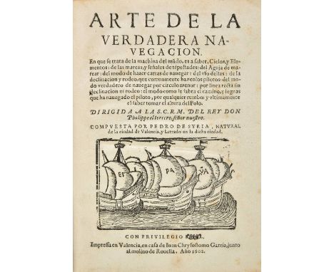
Los 39
Syria (Pedro de). Arte de la Verdadera Navegacion, Juan Chrysostomo Garriz, 1st edition, Valencia, 1602, woodcut of three galleys to title, woodcut initials, 6 woodcut diagrams, word 'Real' after Privilegio to title erased in manuscript, small marginal tear and loss to B4, closed marginal tear to I3, occasional light spotting and toning, Bibliotheca Heberiana stamp to front endpaper, later plain boards, a little rubbed with some fading and stains, small 4to Palau 314796; Sabin 94133. Important early work on navigation. Although Siria did not have practical experience, he proposes in this work many important matters, such as the construction of tables of the variation of the compass; the observation of the distance from the stars to the moon for the purpose of calculating longtitude, and he attributes the variations of the marine compass to the fact that the magnetic pole does not coincide with the actual pole, and places it four or five degrees lower than the other (Maggs). He describes the discovery of America 'Colonia' by 'Colon' (the Spanish form of Columbus) in the dedication to King Philip III. The Library of the University of Valencia keeps two copies in two issues; the first issue (as here) does not contain the imprint of bookseller Francisco Miguel after the line 'al molino de Rouella' at foot of title. Provenance: From the library of bibliophile Richard Heber, which was sold by Sotheby's in thirteen sales from 1834 to 1837. (1)
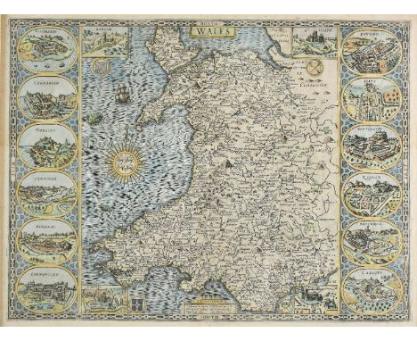
Los 169
*Wales. Speed (John), Wales, published John Sudbury & George Humble, circa 1627, hand coloured engraved map, large compass rose and numerous rhumb lines, 4 inset vignettes of Bangor, St. Asaph, St. Davids and Llandaff, and 12 oval vignettes of principal towns to vertical margins, 2 small worm holes affecting image, 385 x 510 mm, English text on verso, framed and double glazed (1)
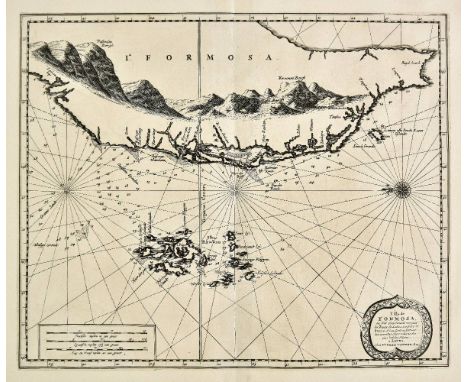
Los 117
Formosa. Van der Aa (Pierre), L'Ile de Formosa ou sont exactement marquez les bancs de Sables, Rochers et Brasses d'Eau..., Leiden, circa 1720, uncoloured engraved map of Formosa and the Pescadore (Penghu) islands, orientated to the east, compass rose and numerous rhumb lines, 290 x 350 mm One of the few maps of Taiwan available to collectors. A good dark impression, originally published in 'Galerie Agr‚able du Monde'; an atlas that is said to have been published in an edition of just one hundred copies. (1)
Los 132
Lancashire. Cary (John), A Topographical Plan of Manchester and Salford with the adjacent parts shewing also the different alloments of land proposed to be built on..., published C. Laurent, 1793, large uncoloured engraved map on two conjoined sheets, inset maps of the road from London to Manchester, the environs of Manchester and a plan of Manchester and Salford taken about 1650, old folds, some repaired and strengthened on verso, slight staining, 1065 x 900 mm, together with Stockdale (John, publisher), A new map of the country round Manchester, 1794, engraved map with contemporay outline colouring, sectionalised and laid on linen, slight fraying where folds cross, 795 x 840 mm, with another copy similar but not laid on linen, plus, Greenwood (C. & G.), Map of the County Palatine of Lancaster from an actual survey..., 1830, engraved map with contemporary hand colouring, calligraphic title, compass rose, table of explanation and an uncoloured vignette of Lancaster Castle and church, slight staining to margins, occasional marginal closed tears, 640 x 685 mm, and The Graphic (publisher), A Bird's-Eye view of Manchester, 1889, large uncoloured panorama, old folds, occasional closed tears, crudely repaired on verso, occasional marginal closed tears, 560 x 1200 mm, together with Canal Map, Plan of the Rochdale Canal and Intended Railway from Sowerby Bridge to Manchester, circa 1830, lithographic plan with sparse outline colouring on three conjoined sheets, some marginal closed tears with occasional loss, some crudely repaired on verso, 400 x 1635 mm, with The Illustrated London News, (publisher), Liverpool, 1865, two uncoloured panoramas of Liverpool and the River Mersey, with key plate and descriptive text, old folds, each approximately 400 x 1055 mm (9)
Los 149
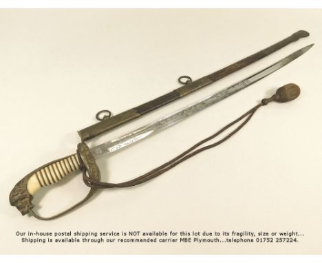
GERMAN NAVAL SWORD.A German naval officer's sword, the single edged blade with crowned king & knight's helmet stamp for W.K. & C. (Weyersberg, Kirscheaum & Co.) Blade in very good condition & etched with fouled anchor under a crown & crossed flags, a battleship & a sailing ship, crossed telescope & sword under compass rose & other devices. Wire bound ivorine grip, lion head pommel set with port & starboard coloured paste eyes, fold-down guard & bullion portapee with original cord. Brass mounted leather scabbard is sound but has some surface loss. Total length 78cm. Length of blade 63cm.
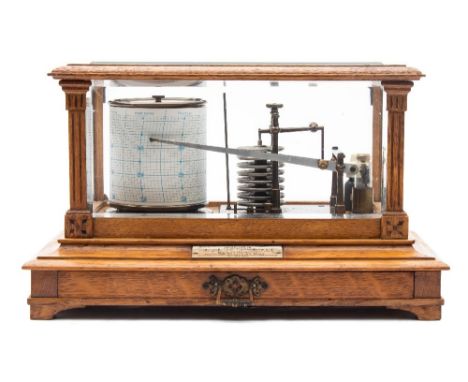
Los 913
Short & Mason, London, an oak cased barograph: the glazed oak case having flat fluted columns to the corners, with a sheet drawer to the front, a plaque attached to the interior base signed Short & Mason, London complete with ink bottle, with a presentation plaque to the front dated 1905, height 21cms. * Biography Short & Mason are recorded as compass and nautical instrument makers at 62 Hatton Garden from 1873 until 1875 and then 40 Hatton Garden until after 1900, being well known for their barographs.
Los 214
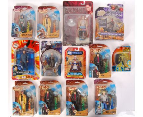
A collection of 13x assorted carded action figures, from various TV & Film franchises. To include; Doctor Who, DC Universe, The Golden Compass, Huntik, The Secret Saturdays, Terminator Salvation and others. All contents appear mint, 1-2 figures may have bubble lift / bubble separation. Good assortment.
-
36562 Los(e)/Seite