36562 Preisdatenbank Los(e) gefunden, die Ihrer Suche entsprechen
36562 Lose gefunden, die zu Ihrer Suche passen. Abonnieren Sie die Preisdatenbank, um sofortigen Zugriff auf alle Dienstleistungen der Preisdatenbank zu haben.
Preisdatenbank abonnieren- Liste
- Galerie
-
36562 Los(e)/Seite

Los 179
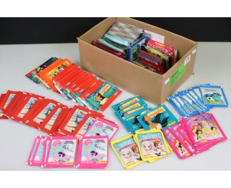
Around 290 Trading Cards & Sticker packs to include Panini (I Love Princess, Pocahontas, The Golden Compass, Monsters University, My Little Pony, The Lion Guard, Cars 3, Frozen & planes) all sealed, Topps (Little Shop of Horrors & Skylanders), ProMatch (Football), Doodlewonkers, Giromax (Angry Birds Space) & SkyBox (Pocahontas) some unsealed

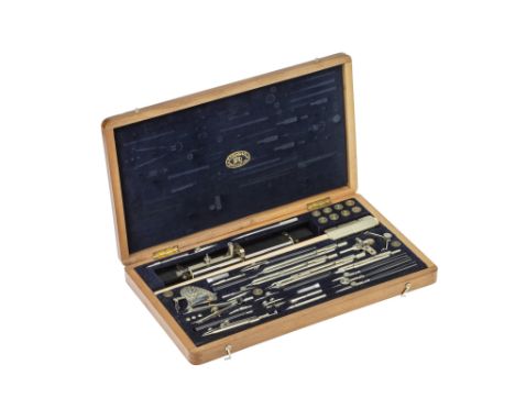
Los 112
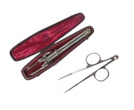
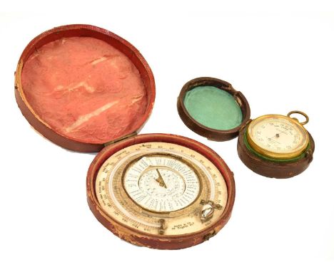
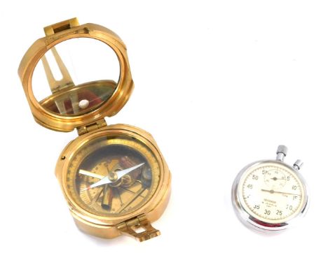
A Superbly Well Engineered Unusual Set of Proportional Dividers, English, c.1870, unmarked, finished in heavy guage German Silver with polished steel tips, with three adjustabel compass type joints, length 23.5cm Note: this is a design we have never seen before, it may be a prototype that never went into production or it may have been a special one off made for a customer.
Los 117
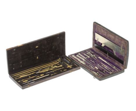
Two Sets of 19th Century Drawing Instruments. comprising one by Kern, c.1850, in nickel silver in embossed leather-covered case, with protractor, scale rule and ebony ruler in lid, (good condition, noting nicks to edge of protractor), with a good quality French set in brass in leather-covered case with gilt decoration case w, c.1840, with beam compass, unsigned (one item missing from lid, leather hinge split). (2) [CITES] Note: This lot contains or is made of ivory and cannot be imported into the USA or any country within the EU.
Los 120
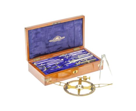
A Set of Drawing Instruments with Survey of India Provenance, English, c.1865, a magazine case of instruments by Stanley, the mahogany veneered case with cartouche engraved ' Presented to Lt. Col. A Strange F.R.S'. with proportional dividers, beam compass ends etc, the lower compartment with a few items including an ivory sector and a road pen by Reeves. [CITES] Provenance: originally the property of Alexander Strange (1818-1876). Educated at Harrow, Strange received a commission in the 7th Madras Light Cavalry in 1834. After studying at the Magnetic and Meteorological Observatory in Simla, in 1847 he was appointed second assistant to the Great Trigonometrical Survey of India. He was employed on the Karachi Longitudinal Series, by 1850 he took chief command of that project. He later organised the establishment of a department for inspection of scientific instruments for use in India, and designed and superintended the construction of massive theodolites and transit instruments. He was elected a fellow of the Royal Geographical Society and Royal Astronomical Society, and in 1864 the Royal Society. Note: This lot contains or is made of ivory and cannot be imported into the USA or any country within the EU.

Los 130
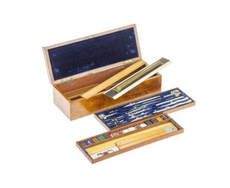
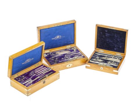
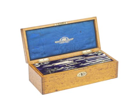
A Stanley Magazine Case of Drawing Instruments, English, c.1880, a large, comprhensive nickel silver set in oak case, the upper tray with large proportional dividers, beam compass ends, dotting pen etc; the next tray with ebony and brass rolling rule, ivory protractor/scale rule, ivory sector, a set of seven boxwood scale rules and two smaller in ivory, architect's pins; lower compartment with French curves and set squares in pearwood an mahogany; below is a sprung drawer released by a button, revealing a porcelain palette, watercolours and an empty compartment for brushes [CITES] Note: This lot contains or is made of ivory and cannot be imported into the USA or any country within the EU.
Los 131
A Stanley Magazine Case of Drawing Instruments, English, c.1880, a large, comprhensive nickel silver set in blond oak case, the upper tray with large proportional dividers, beam compass ends, dotting pen etc; the next tray with nickel-silver rolling rule, ivory protractor/scale rule, ivory sector, a set of six ivory scale rules, some good additional pens, architect's pins etc.; lower compartment with some very good additional Stanley Instruments including patent circular protractor, proportional dividers with turn-down points, bar adjustment proportional dividers, large turn-about compasses etc.; below is a sprung drawer released by a button, revealing a porcelain palette, watercolours, border pen etc. [CITES] Note: This lot contains or is made of ivory and cannot be imported into the USA or any country within the EU.
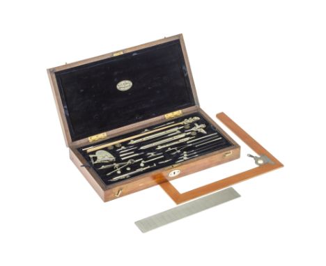
Los 136
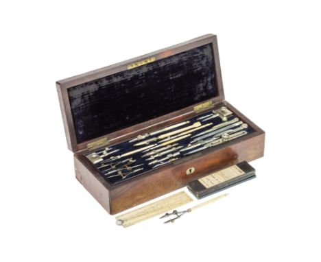
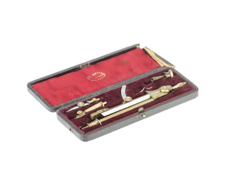
An Early Set of Drawing Instruments by Thomas Heath, English, c. 1730-1740, black sharkskin covered case with instruments in gree velvet lined fitted interior, instruments include fine proportional dividers with locking cross-bar and ropework knurled knobs, engraved 'T Heath London', large compass with locking interchangable ink, pencil and divider ends, dividers with sprung fine adjustment by wingnut, a steel point tracer (?) that unscrews to become a pricker (thread worn), ink drawing pen, pencil and original combination adjustment tool/file/penknife (tool fits compass joint),the green silk lid interior lifts to reveal the fine brass sector with cross bar, and empty compartment probably for a parellel ruler, case 18.6cm across
Los 148
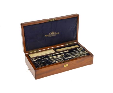
A Good Set of Drawing Instruments, Stanley, English, c.1900, singed to the inside of the lid 'STANLEY, GREAT TURNSTILE, HOLBORN W.C. & RAILWAY TERMINUS, LONDON BRIDGE', the French polished mahogany case with cartouche engraved 'W. BAINBRIDGE '. with proportional dividers, beam compass ends etc, the lower compartment with a good swing arm protractor signed 'Stanley' an ivory sector and other items, case 34cm.[CITES] Provenance: bought from Mallams Auctions Lot 10, 01/12/2014 Note: This lot contains or is made of ivory and cannot be imported into the USA or any country within the EU.
Los 149
A Good & Large Set of Drawing Instruments, English, c.1880, unsigned but one set of dividers with a retail engraving for C. Baker 244 High Holborn, London, the mahogany veneered case with cartouche engraved ' W. G. Jones'. with proportional dividers, compass etc, the next compartment with rules and a beam compass, the lower compartment with a few items including a boxwood sector, the case 32cm. [CITES] Note: This lot contains or is made of ivory and cannot be imported into the USA or any country within the EU.
Los 150
A Case of Drawing Instruments, Stanley, English, c.1880, by Stanley , the French polished mahogany case with lift out tray containing proportional dividers, beam compass ends etc, the lower compartment with a few rules and protractor, case 36cm. [CITES] Provenance: originally the property of Charles William Cocks, a soldier who fought in the trenches of the great war. He returned to England and became an engineer on the railways. Note: This lot contains or is made of ivory and cannot be imported into the USA or any country within the EU.
Los 152
Large Set of Drawing Instruments, English, c.1880, unsigned , the French polished burr walnut veneered case with German silver escutcheon and plaque. top velvet lined tray containing proportional dividers, compass etc, the next compartment with rules and paints, the lower compartment with ebony & brass roller rule, boxwood rules the case 36cm. [CITES] Note: This lot contains or is made of ivory and cannot be imported into the USA or any country within the EU.
Los 153
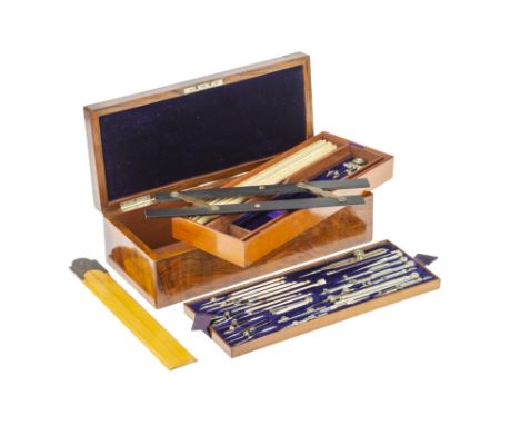
Three Sets of Drawing Instruments, Comprising of a set by Elliot, c.1880, French polished light oak with German silver bindings, top velvet lined tray with unusual beam compass, compasses, proportional dividers and pens, bottom section with ivory sector, rules and other items, case 22cm; a set by Stanley, c.1900, French polished light oak with German silver bindings, top velvet lined tray with compasses, proportional dividers and pens, bottom section with ivory rules and other items, case 27cm; a set by Stanley, c.1900, French polished light oak with German silver bindings, top velvet-lined tray with compasses, proportional dividers and pens, second tray with pens and large universal compass, bottom section with a few set squares, case 27cm, (3) [CITES] Note: This lot contains or is made of ivory and cannot be imported into the USA or any country within the EU. Note: This lot contains or is made of ivory and cannot be imported into the USA or any country within the EU.
Los 155
A 'Marvel' Geometric Compass, J. F Bennett, English, c.1880, signed to the instrument and to the lid of the case 'J. F. Bennett, Patentees, Sheffield', constructed similar to a compass but designed to follow the contour of a small adjustable ellipse, with pen and pencil attachment, in leather covered case lined with red silk and velvet Footnote: for a similar instrument see object 1887-34/2 at the science museum collection - https://collection.sciencemuseumgroup.org.uk/objects/co8641663/bennett-patent-compasses-in-case

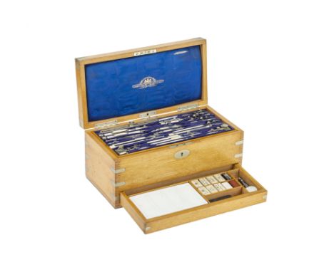
Los 159
A Fine Magazine Case of Drawing Instruments by Stanley, English, c.1890, substantial oak case, the lid lined with watered silk with gilt trade label, the top tray with proportional compass, beam ompass ends, dotting pen with ivory handle etc., the second tray with a rolling rule, scale rules in boxwood and ivory, an ivory scale rule/protractor etc., the lower compartment containing a porcelain palette, case 36.6cm across [CITES]Note: This lot contains or is made of ivory and cannot be imported into the USA or any country within the EU.
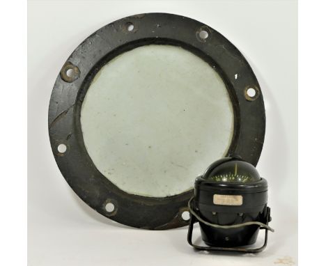
Los 163
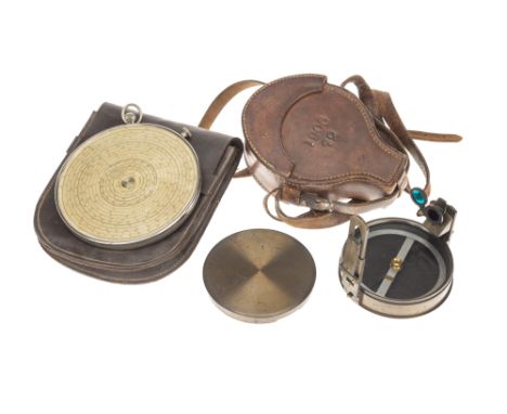
Large Fowlers Calculator, with a Military Compass, the slide rule Englsh, c.1910, nickel plated with glass cover, paper scale printed 'Fowlers Magnum Patent Long Scale Calculator Fowler & Co Manchester', (crown winder that rotates the scales sometimes does not locate)11.8cm diameter; with a Stanley compass, case dated 1906, prismatic, with sights, mirror and two filters,lacquered brass case marked with broad arrow, in leather case with strap, compass diameter 8.9cm
Los 164
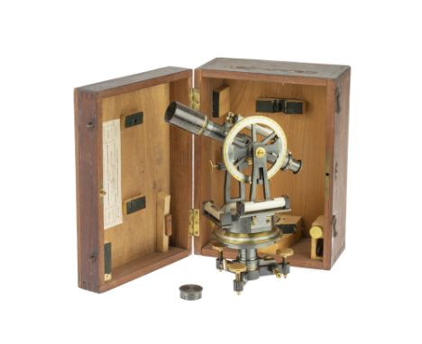
A 4in French Theodolite by Morin, Paris, French, c.1870, signed to the silvered compass face H Morin 3 Rue Boursault, a Pais' on three screw feet, horizontal circle with clamp vernier screw and double vernier scales, silvered compass, two spirit levels, telescope with rack and pinion focus, spirit level and dust cap, in original fruitwood case with Morin's trade label to inside of lid, instrument height 29cm
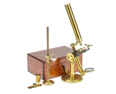
Los 180
A Brass Compound Microscope, Dixey, English, c.1880, signed in script to the back of the circular base 'C. W. Dixey Optician to the Queen, New Bond St. London', the microscope on a heavy lead filled brass base on a single pillar with a compass type joint at the top, with a sprung simple stage, rack and pinion focusing to a triangular bar, with objective, stage forceps, live box and a few slides, all in a French polished mahogany case with key, assembled microscope height 37cm
Los 182
18th Century Compass Microscope, English, c.1750, unsigned, consisting of a delicately turned handle which screws into the base of the body of the microscope, the body with reversible forceps and interchangeable specimen holder, top section to hold lenses snapped off and missing, with 4 Lieberkühn eyepieces, two with very early turned horn inserts to hold the lenses in place, in the original sharkskin covered case lined with green silk velvet and edged in red, with both hinges and catches, case width 13.3cm Note: This lot contains or is made of ivory and cannot be imported into the USA or any country within the EU.
Los 191
A Late 18th Century Compound Chest Microscope By Dollond, London, English, c.late 18th century, signed to the body tube in large font 'DOLLOND LONDON' microscope column on large compass type joint to base of case, square column supporting plano-concave mirror in a gimbal on sliding collar, rack and pinion focusing to rear of cruciform stage, stage with slot for stage forceps/fish plate and stage bull's-eye condenser, with six numbered objectives, fish plate, live boxes, and other accessories in the original French polished mahogany case Provenance: From the sale of the collection of Dr MacKinnon.
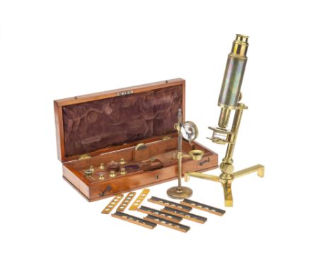
Los 192
A Crichton 'Improved Compound Microscope', English, c. 1830, engraved to the foot 'Improved Compound Microscope by Crichton, 112 Leadenhall St, London, the body tube with rack and pinion focusing, supported by barlimb at top of the column, compass joint and folding flat tripod base, in fitted mahogany case with candle holder and condenser, set of bone and boxwood mounted slides, seven numbered objectives, livebox, the French polished mahogany case 40cm wide. Footnote: for a similar instrument see G L'E Turner, The Great Age of the Microscope, p.73
Los 220
A Rare 'Dr. G. Johnstone Stoney's Improved Heliostat', By Watson & Sons, English, c.1890, signed to a plaque on the base 'W. Watson & Sons, Manufacturers, 313 High Holborn, London', the base constructed of French polised Spanish mahogany with 3 large screw feet and 2 recessed spirit levels, the heliostat body containing the clockwork (working but untested) on a hinged base with graduated clamp, top engraved with compass points, with geared adjustments, missing the mirror and the mirror support, base 26 x 28 Footnote: this is part of a collection of instruments from the Oxford University Physics Department
Los 235
A 2in Library Brass Telescope, English, c.1860, unsigned but with a letter of instructions pasted to the inside of the case lid for Negretti & Zambra, the telescope constructed entirely of lacquered brass, with rack and pinion focusing, with 2 eyepieces, on folding brass tripod, with compass type joint at top, in original mahogany case, assembled length 95cm
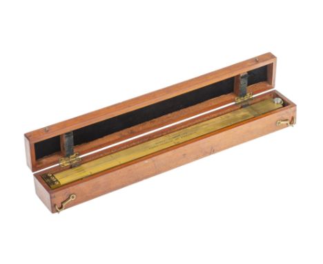
Los 89
Corporation of Preston, Folding Standard Yard, 1908, English, date stamped 1908, engraved along the length 'CORPORATION OF PRESTON' and 'W & T Avery Ltd London', the scale with multiple Exchequer and verification marks and engraved in inches, with compass type joint to the centre, in mahogany case with large brass plaque engraved 'CORPORATION OF PRESTON' and 'W & T Avery Ltd London',
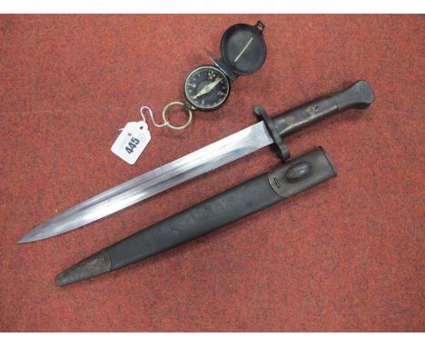
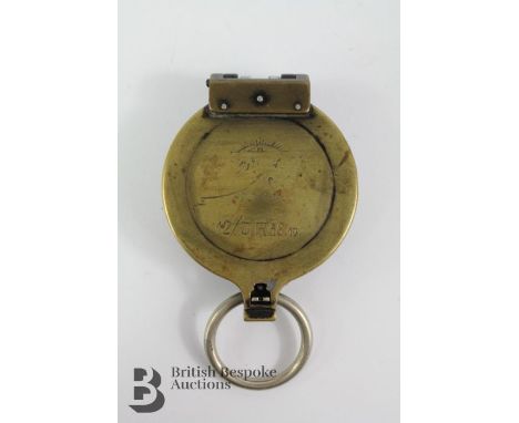
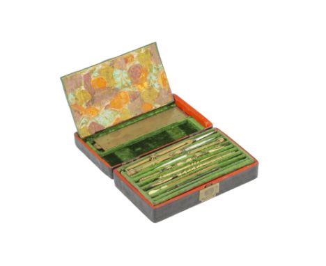
Los 88
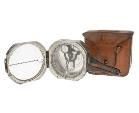
WWII era brass German Officers marching compass, stamped BUSCH DRGM 12 Jäger Reg 58.19. The compass bears a personalised inscription to the front which reads as 12/J.R.58.19 which may imply 'light infantry'. The compass is in full working order and has luminous markings to the face, 7 x 5.2 cms.
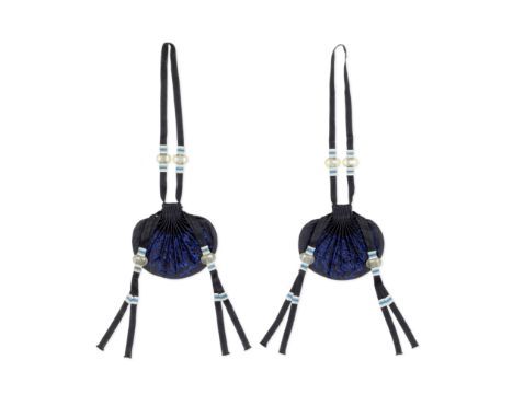
Los 144
A RARE PAIR OF IMPERIAL MIDNIGHT-BLUE-GROUND EMBROIDERED SILK PURSES19th century Each shell-shaped ceremonial purse elegantly embroidered on each side with multiple branches issuing lingzhi fungi in vibrant blue thread, each pouch lined in Imperial yellow silk sealed at the neck and tied with a pair of silk deep blue cords and tapes with moonstone-coloured glass beads. 10.5cm (4 1/8in) wide (2).Footnotes:十九世紀 御製石青地繡靈芝紋荷包一對Silk pouches, such as the present pair, formed an essential part of the formal ceremonial costumes worn by the Qing emperors and the highest-ranking members of society. The present pair may have been paired to the blue ceremonial silk robe, chaofu, worn by the emperor for the performance of rites aimed at invoking rain and good harvest at the Altar of Heaven. See a similar pair of dark purses depicted in the Huangchao Liqi Tushi 皇朝禮器圖式 ('Illustrated Precedents for the Ritual Paraphernalia of the Imperial Court'), edited in 1759, illustrated in The Complete Collection of Treasures of the Palace Museum. Costumes and Accessories of the Qing Court, Shanghai, 2005, no.2.The Huangchao Liqi Tushi 皇朝禮器圖式 ('Illustrated Precedents for the Ritual Paraphernalia of the Imperial Court'), edited in 1759, prescribed this type of purses to wear over formal court robes by suspending them from ceremonial belts, chaodai and Qing emperors frequently appeared in formal portraits wearing dark-blue purses, similarly shaped as the present pair; see the formal portrait of the Qianlong emperor by Giuseppe Castiglione, clad in a yellow-ground silk ceremonial outfit including a chaodai suspending a pair of dark-blue silk purses similarly shaped as the present examples; L.Wrigglesworth, Imperial Wardrobe, Berkeley, 2000, p.47, pl.36. Drawstring purses affirm the nomadic origin of the Manchu, as they probably developed from carrying purses made of leather which often contained pieces of flint needed to strike a flame, fundamental to the Manchu way of life. As the Manchu settled in China, cases made for knife and compass were gradually replaced by cases made for fans, kerchief holders and other items suggesting the more leisurely and scholarly existence of the Chinese literati. Once established in China, the Manchu emperors often kept areca nuts in the purses, but also scented cotton and aromatic herbs.For further information on this lot please visit Bonhams.com
Los 2683
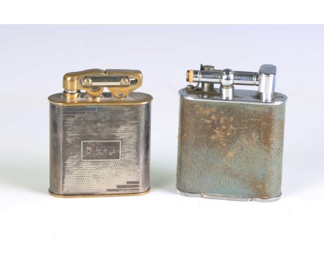
An Art Deco Elisorn Auto-Tank silver plated table lighter, height 10cm, another 'Jumbo' lighter and a pocket compass by Stanley.Buyer’s Premium 29.4% (including VAT @ 20%) of the hammer price. Lots purchased online via the-saleroom.com will attract an additional premium of 6% (including VAT @ 20%) of the hammer price.
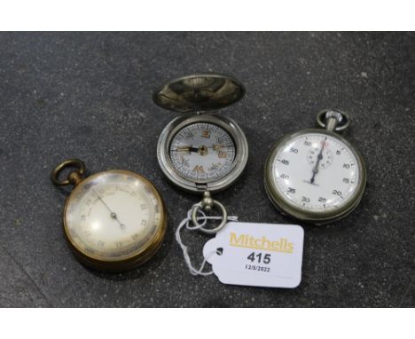
Los 104
1 3/4" diameter dial (cased) together with Ross & Co. Circular thermometer with compass on ivory base 4" diameter (cased) (2)Barometer passes bag test, has tarnishing to edge of face otherwise fairly minor wear, case a little worn; Compasssome wear mainly to compass label and outer dial dirty, part of edging to compass missing (a piece approx 2cm long), case worn
Los 105
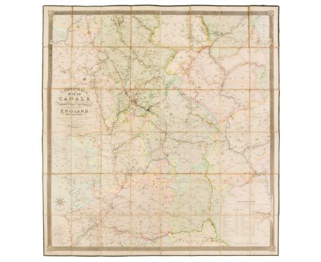
Canal Map. Bradshaw (G.), Map of Canals, Navigable Rivers, Railroads etc. of the Midland Counties of England from Actual Survey, shewing the heights of the Ponds on the Lines of Navigation from a Level 6ft. 10in. under the Old Dock Sill at Liverpool, from levels taken by Twyford & Wilson, Surveyors and Engineers, published G. Bradshaw, Manchester and sold by Mr Jas. Gardner, London, Feby. 12th. 1830, large engraved map with contemporary outline colouring, sectionalised and laid on linen, calligraphic title, table of explanation and compass rose, slight offsetting, edged in green silk, 1320 x 1240 mmQTY: (1)
Los 106
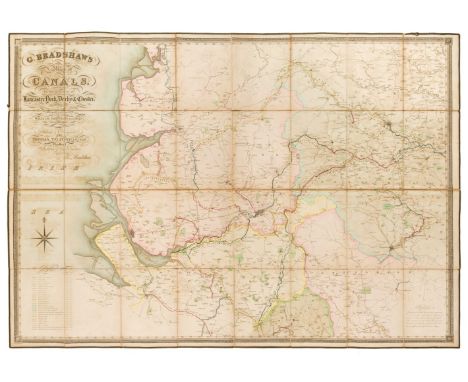
Canal Map. Bradshaw (G.), Map of Canals situated in the Counties of Lancaster, York, Derby & Chester; shewing the heights of their pools above the level of 6 ft. 10 in. under the Old Dock Sill at Liverpool. From Levels taken by William Johnson and Son, Manchester and dedicated by permission to Thomas Telford..., circa 1830, large engraved map with contemporary outline colouring, sectionalised and laid on linen, calligraphic cartouche, compass rose and tables of explanation and reference, some offsetting, edged in green silk, 890 x 1270 mm, marbled endpapersQTY: (1)
Los 107
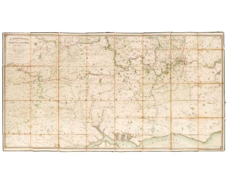
Canal Map. Bradshaw (G.), Map of the Canals, Navigable Rivers, Railways, &c. in the Southern Counties of England from Actual Survey Shewing the heights of the Pools and the Lines of Navigation, also the Planes on the Railways from a level of 6ft. 10in. under the Old Dock Sill at Liverpool, Dedicated by permission to Thomas Telford..., circa 1830, large engraved map on three conjoined sheets, with contemporary outline colouring, sectionalised and laid on linen, calligraphic cartouche, table of explanation and compass rose, slight offsetting, edged in green silk, 960 x 1865 mmQTY: (1)
Los 111
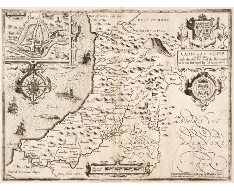
Cardiganshire. Speed (John), Cardigan Shyre Described with the due forme of the Shiretown as it was surveyed by J. S. John Sudbury & George Humble circa 1614, uncoloured engraved map, inset town plan of Cardigan, large strapwork cartouche, compass rose and milage scale, slight staining, two wormholes to the lower margin but not affecting the printed surface, 380 x 510 mm, English text on verso, together with Kitchin (Thomas). An Accurate Map of Cardigan Shire Drawn from an Actual Survey with Various Improvements..., circa 1765, engraved map with contemporary outline colouring and some later enhancement, lower margin trimmed to the neatline with a later paper extension, 345 x 530 mm, mounted, framed and glazedQTY: (2)
Los 113
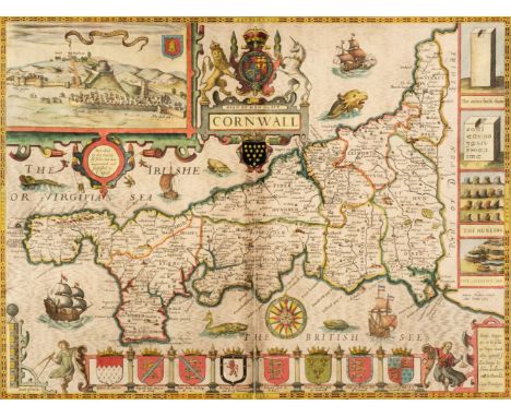
Cornwall. Speed (John & Norden John), Cornwall, John Sudbury & George Humble, circa 1627, hand-coloured engraved map, inset view of Launceston, large strapwork cartouche and compass rose, slight creasing, central fold partially split and crudely repaired on verso, slight staining and dust soiling, 380 x 510 mm, English text on verso, mounted, framed and double glazed, together with Devonshire with Excester Described and the Armes of such Nobles as have borne the titles of them, Thomas Bassett & Richard Chiswell [1676], hand-coloured engraved map, inset plan of Exeter, several repaired closed tears affecting the image, slight staining, torn with a very small area of loss to the lower right corner, 375 x 505 mm, mounted, framed and glazedQTY: (2)
Los 114
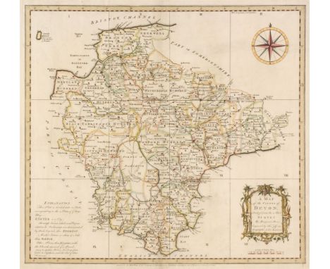
Devon. Donn (Benjamin), A Map of the County of Devon, abridged from the 12 sheet Survey, February 1st 1765, hand-coloured engraved map by Thomas Jefferys, decorative cartouche, compass rose and table of explanation, slight spotting, 505 x 545 mm, together with Bowen (Emanuel). An Accurate map of Devon Shire Divided into its Hundreds, Drawn from the best Authorities..., Carington Bowles & Robert Sayer, circa 1765, engraved map with contemporary outline colouring and some later enhancement, inset plan of Plymouth, long repaired closed tear affecting the printed surface, central fold strengthened on the verso, occasional marginal closed tears, slight staining and dust soiling, 535 x 680 mmQTY: (2)NOTE:Batten & Bennett, The Printed Maps of Devon, 45. Published as the key plate for Donn's large scale map of Devon but often found as a separate map.
Los 121
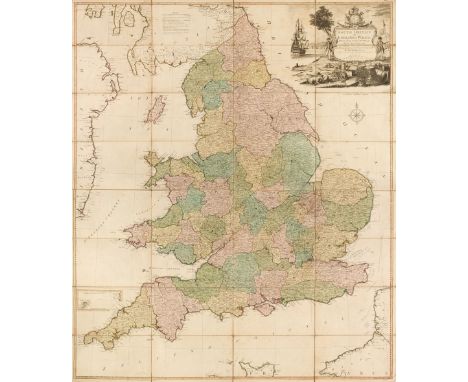
England & Wales. Kitchin (Thomas), South Britain or England & Wales, Drawn from several surveys &c. on a new projection corrected from astronomical observations & the places marked where the observat.ns were made, R. Sayer, 1787, engraved map with contemporary outline colouring, sectionalised and laid on linen, inset map of the Scilly Isles, large uncoloured decorative cartouche, the cartouche incorporates a coastal scene with a ship, a soldier and a sailor and a spread of artefacts representing British trades, including sheep, wheat and cannonballs, compass rose and table of remarks, slight dust soiling and spotting, 1275 x 1090 mm, together with Stanford (G. publisher). Stanford's Map of the New Probate Districts of England and Wales...., 1858, lithographic map with contemporary outline colouring, sectionalised and laid on linen, slight dust soiling and staining, 950 x 805 mm, contained in a publisher's red cloth slipcase with printed label to the upper cover, some wear to the extremities, with Laurie (Richard Holmes). England, circa 1870, engraved map with contemporary outline colouring, sectionalised and laid on linen, inset maps of Scilly Isles and the Channel islands, 800 x 630 mm, marbled endpapers, bound in contemporary green cloth boards, very slight wear to extremities, plus Geike (Sir Archibald). Geological Map of England & Wales..., John Bartholomew & Co. 1897, colour lithographic map, sectionalised and laid on linen, inset tables of explanation, 1020 x 840 mm, bound with a 28-page pamphlet of explanatory text, bound in contemporary blue cloth gilt, boards water stained and warped, and Philip (George and Son, publishers). Philip's Cyclist's Map of England and Wales, circa 1890, colour printed lithographic folding map, laid on linen, inset map of the Environs of London, 805 x 610 mm, some spotting and creasing, bound in contemporary blue boards, worn at extremitiesQTY: (5)
Los 132
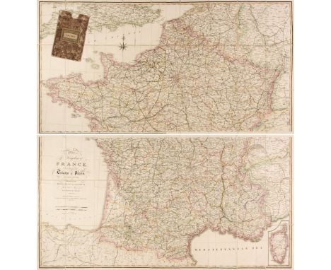
France. Wyld (James), Wyld, Map of the Kingdom of France according to the Treaty of Paris, November 20th 1815, Divided into Departments and Districts from the Map of M. Cassini de Theury, April 4th 1825, large engraved map with contemporary outline colouring, sectionalised and laid on linen, on two sheets, inset map of Corsica, calligraphic cartouche and compass rose, each sheet 615 x 1180 mm, contained in a contemporary marbled card slipcase with a publisher's printed label to the upper cover and spineQTY: (1)NOTE:A fine example of Wyld's reduction of Cassini's monumental map of France. After Napolean's defeat in 1815, France underwent the Bourbon Restoration with Louis XVIII being restored to the throne, which would last until the July revolution of 1830.
Los 140
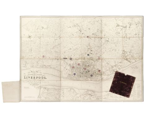
Liverpool. Bennison (Jonathan), Bennison's Map of the Town and Port of Liverpool with their Environs including Seacombe, Woodside, Birkenhead, Tranmere &c. from actual survey, Liverpool, 1846, large map, engraved by John Dower, with contemporary outline colouring, additional watercolour circles marking the locations of water tanks and reservoirs, with a manuscript explanation key, sectionalised and laid on linen, calligraphic cartouche, compass rose and table of reference, slight offsetting, three manuscript sheets of paper giving details of the water tanks and reservoirs stitched to the lower left margin, 1280 x 1780 mm, contained in a contemporary morocco gilt slipcase, case worn and rubbedQTY: (1)NOTE:Originally published in 1835, this later example has been utilised by the Liverpool waterworks company to map and record the location of the water system and reservoirs.
Los 150
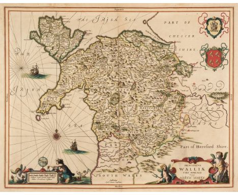
North Wales. Jansson (Jan), Principatus Walliae pars Borealis vulgo North Wales, Amsterdam, circa 1648, engraved map with contemporary outline colouring, decorative cartouche and mileage scale, compass rose and numerous rhumb lines, slight staining, but largely confined to the margins, 405 x 515 mm, Latin text on verso, together with Bowen (Emanuel). A Map of the Six Counties of North Wales Divided into their respective Hundreds..., H. Parker, J & C Bowles, H, Overton, J. Ryall, R. Sayer and T. Kitchin, circa 1762, engraved map with contemporary outline colouring, originally published in 'The Royal English Atlas', one small rust stain, 410 x 515 mm, with Schenk (P. & Valk G.). Principatus Walliae pars Borealis vulgo North Wales, Amsterdam [1714 - 24], engraved map with contemporary outline colouring, decorative cartouche and mileage scale, compass rose and numerous rhumb lines, 405 x 515 mm, no text on verso, plus Mercator (Gerard & Hondius Henricus). Westmorlandia, Lancastria, Cestria, Caernarvan, Denbigh, Flint, Merionidh, Montgomery, Salopia cum insulin Mania et Anglesey, circa 1630, uncoloured engraved map, 360 x 415 mm, Latin text on versoQTY: (4)
Los 163
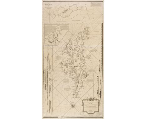
Shetland Islands. Preston (Capt. Thomas), A New Hydrographical Survey of the Islands of Shetland..., Regulated by the Determination of the Chevr. de Lovenorn &c. with Sailing Directions, Laurie & Whittle, 2nd edition, Considerably Improved, 1st March 1810, large uncoloured engraved sea chart on three conjoined sheets, large maritime cartouche, compass rose and numerous rhumb lines, horizon profiles and inset maps of Brassa Sound and Valey Sound, 1140 x 585 mmQTY: (1)NOTE:Scarce. There are only two copies recorded on Copac and both are earlier editions, not matching this later state.
![Worcestershire. Speed (John), Worcestershire Described, John Sudbury & George Humble [1616], hand-coloured engraved map,](https://cdn.globalauctionplatform.com/e9dc0ac2-559f-4025-a874-ae7e01100a9c/ce7a25b5-ea63-4071-b5de-ae7f00f6f85b/468x382.jpg)
Los 176
Worcestershire. Speed (John), Worcestershire Described, John Sudbury & George Humble [1616], hand-coloured engraved map, inset town plan of Worcester, large strapwork cartouche and compass rose, central fold strengthened on verso, 380 x 500 mm, Latin text on verso, together with Doharty (John). A Plan of the City of Worcester with References, 1741, uncoloured engraved city plan, slight creasing and dust soiling, one repaired closed tear affecting the printed image, 475 x 585 mm, with Moll (Herman). Worcestershire, circa 1720, hand-coloured engraved map, the vertical margins decorated with antiquities, 195 x 315 mm, plus Schenk (P. & Valk G). Wigoriensis comitatus cum Warwicensi nec non Coventriae Libertas, Amsterdam, circa 1700, engraved reticulated map with contemporary hand-colouring, uncoloured cartouche, heraldic shields and mileage scale, 430 x 520 mm, and Van den Keere (Pieter). Worcestershire, circa 1627, hand-coloured engraved miniature map, small margins, 85 x 125 mm, English text on versoQTY: (5)
-
36562 Los(e)/Seite