36562 Preisdatenbank Los(e) gefunden, die Ihrer Suche entsprechen
36562 Lose gefunden, die zu Ihrer Suche passen. Abonnieren Sie die Preisdatenbank, um sofortigen Zugriff auf alle Dienstleistungen der Preisdatenbank zu haben.
Preisdatenbank abonnieren- Liste
- Galerie
-
36562 Los(e)/Seite


Los 346
*A collection of wrist watches, predominantly gentleman`s with some lady`s models present, various movement types, brands include: Diesel; Fossil; Seiko; Pulsar; Kahuna; and Amette; varied state and condition; one Diesel watch is cased; in excess of 110 watches; also includes a brass pocket compass inscribed Beck London to the case

Los 352
A collection of silver and objects of vertu, including: a silver covered glass dressing case box, Birmingham 1921, engraved `EB` and engine turned; a silver and shagreen cigarette case, London 1931, retailer`s mark for Wilson & Gill, Regent St (damages); two silver match box holders; a gilt metal and ivory opera glasses, in a leather case; a military pocket compass, the case black finished; miniature and small books; a pencil and watercolour on paper of a woman gathering sticks, initialled and dated 1824, framed; and other items


Los 220
Victorian silver fob compass of circular form with engraving of a paddle steamer, the hinged cover opening to reveal a compass set in the base and woven lock of hair in the top (Birmingham 1891) - maker J A, 2.1cm diameter Further images and condition reports are available at www.reemandansie.com


Los 153
Collins (Greenville) Dartmouth chart of the river Dart with inset of Tarr Bay and 3 inset coastal recognition views north oriented to the right decorative title cartouche of putti and fish with dedication to Lord Dartmouth upper left scale cartouche of fish traps and bullrushes centre right compass rose engraved chart with original hand-colouring 455 x 575mm. central vetical fold slight surface dirt c.1765 § Sayer (Robert) A Chart of the Isle Roads and Race of Portland with the Shambles c. title cartouche upper centre compass rose and rhum lines engraved chart with original hand-colouring 520 x 710mm. central vertical fold slight browning and spotting 1791 (2)

Los 175
Ogilby (John) An Actuall Survey of Midlesex county map with large armorial title cartouche figurative dedication and scale cartouches compass rose engraved map by Walter Binneman with hand-colouring 420 x 530mm. central vertical fold a dampstain upper right a few small letters below title touched in George Willdey c.1730. *** Rare. Ogilby planned his own atlas of English counties but only produced three Kent Essex and Middlesex. This example was re-issued by George Willdey at his Great Toy Spectacle China Ware and Print Shop in his edition of Christopher Saxton`s atlas.

Los 198
De Wit (Frederic) Magnæ Tartariæ Magni Mogolis Imperii Japonæ et Chinæ nova descriptio a detailed map of Tartary including China and Japan with decorative title cartouche upper right rhum lines and compass rose engraved map with outline hand-colouring 440 x 540mm. central vertical fold slight browning and surface dirt some minor rust spots Amsterdam c.1660.

Los 222
Seutter (Matthaeus) India Orientalis cum Adjacentibus Insulis South-East Asia from India to Japan the outline north coast of Australia joined to Papua New Guinea with large figurative title cartouche depicting a missionary preaching to native figures to the left others pay tributes to classical deities on the right with compass rose and rhum lines engraved map with original hand-colouring the cartouche also fully coloured possibly later 500 x 575mm. central vertical fold Augsburg c.1730.

Los 235
Dudley (Sir Robert) Una carta dell`Arcipelago con parte del Mare mediterraneo verso Levante the eastern Mediterranean from Dudley`s Dell`Arcano del Mare title cartouche upper left large compass rose upper right ship and sea monsters engraved map by Antonio Francesco Lucini on laid paper 435 x 365mm. [Florence] (1646-61). *** The explorer and cartographer Sir Robert Dudley (1574-1649) went into self-imposed exile after failing to establish his legitimate title to succeed his father Robert Dudley 1st Earl of Leicester despite having inherited his entire estate. He settled in Florence where he produced the maritime atlas by an Englishman the Arcano del Mare being also the first to cover the entire world each chart devised on a uniform projection.

Los 244
South America.- Blaeu (Willem) Peru with north oriented to the left decorative title cartouche upper left ships sea monsters and large compass rose engraved map with originla hand-colouring 380 x 495mm. Dutch text verso central vertical fold and wide margins browning and slight spotting Amsterdam c.1650; with Chart of the North Coast of Brazil from St John`s Island to the River Preguicas by Lieut George Crichton R.N. 490 x 640mm. central fold and a soft crease Capt. Hurd at the Hydrographical Office 1814 (2)


Los 308
A brass Cathedral skeleton clock rising from a stepped base with 2 recumbent lions on plinth and central compass, the minimal tower shaped frame with decorative finials and the single fusee movement having a ring pierced steel dial with painted Roman numerals. The whole mounted on a stepped oblong white marble plinth with squat bun feet and protected by a glass dome cover which is as viewed (clock stands 38cms)


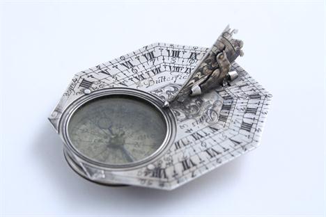
Los 184
A SMALL LATE 17TH / EARLY 18TH CENTURY BUTTERFIELD POCKET DIAL octagonal with compass, adjustable folding gnomon with bird beak pointer, incised & filled with four concentric hour scales, the reverse incised & filled with European towns & cities & their latitudes, signed "Butterfield a Paris", c.1700; 2.3" (5.8 cms) long; 0.75 oz gross


Los 250
A collection of maps of Arabia comprising `A New Map of Arabia Divided into its Several Regions and Districts`, being a hand tinted map by Monsieur D.Andille, published by Laurie & Whittle, 53 Fleet Street, London, 1794, showing Arabia and various islands around the Red Sea, 47x79cm, unframed, `Carte De L`Entre`e du Golfe de La Merrouge`, being a map showing the Arabian coast with the Isle of Socotra, circa.1780, 33x49cm, unframed, `Persian Gulph`, from the original by D`Anville, showing the various towns around the Persian Gulph, circa.1790, 29x43cm, `A Large Draught of The Coast of Arabia from Maculla to Dofar`, being a hand tinted map with two decorative compass roses, circa.1790, 43x53cm, unframed, `A Plan of the Road of Geddah, on The Western Coast of Arabia in the Red Sea`, by Monsieur D`Apre`s de Mannevillete, printed for R Sayer & J Bennett, Map & Chart Sellers, Fleet Street, London, 1778, 49x33cm, unframed, also a map of Arabia printed by J & F Talis, London & New York, late 19th century, a collection of copies of historic maps of the Gulf, hand tinted map of Delamere Forest, dated 1813, a reproduction map of England after Robert Morden and a modern forestry record map (illustrated)


-
36562 Los(e)/Seite