Surrey. Bryant (Andrew), Map of the County of Surrey from actual survey by A. Bryant in the years 1822 and 1823..., June 1st 1823, large scale engraved map with contemporary colouring, sectionalised and laid on linen, calligraphic title and compass rose, list of ecclesiastical divisions and table of explanation, some offsetting, edged in green silk with slight fraying, green endpapers, 1510 x 1955 mm, contained within contemporary book box (very rubbed and worn with loss)QTY: (1)
36562 Preisdatenbank Los(e) gefunden, die Ihrer Suche entsprechen
36562 Lose gefunden, die zu Ihrer Suche passen. Abonnieren Sie die Preisdatenbank, um sofortigen Zugriff auf alle Dienstleistungen der Preisdatenbank zu haben.
Preisdatenbank abonnieren- Liste
- Galerie
-
36562 Los(e)/Seite
Essex. Greenwood (C & J), Map of the County of Essex, from an actual survey made in the year 1824..., Greenwood, Pringle & Co. July 1st 1825, large scale uncoloured engraved map, sectionalised and laid on linen, calligraphic cartouche, table of explanation, compass rose and a vignette view of Audley End House, edged in green silk with some fraying, some offsetting and spotting, 1330 x 1570 mm, contained in a later slipcase (rubbed) QTY: (1)
* Derbyshire. Speed (John), Anno Darbieshire described, Thomas Bassett & Richard Chiswell [1676], hand-coloured engraved map, inset town plan of Derby and a vignette of St. Anne's Well at Buxton, large strapwork cartouche and compass rose, large margins, 385 x 510 mm, mounted, framed and double-glazed, English text on verso, together with Blaeu (Johannes). Darbiensis Comitatus Vernacule Darbie Shire, Amsterdam circa 1646, engraved map with contemporary outline colouring, large allegorical cartouche and mileage scale, 385 x 505 mm, German text on versoQTY: (2)
Bristol Channel. Collins (Captain Greenville). Untitled chart of the Bristol Channel, circa 1780, uncoloured engraved sea chart, inset view of the King Road, compass rose and numerous rhumb lines, slight spotting and toning, slight creasing, 440 x 545 mm, together with Walker (J. & C.). England West Coast Sheet II, Padstow to the Bristol Channel, 1839, corrected to 1842, uncoloured engraved sea chart, stamp of the Hydrographic Department, six inset horizon profiles, slight dust soiling, 635 x 480 mm, with Geological Survey of England and Wales. Exeter (Tiverton) & Teignmouth (Exeter), engraved at the Ordnance Survey Office, revised and published 1898, two engraved geological maps with contemporary hand-colouring, each with an index key and a blind stamp in the upper margin of the Board of Agriculture, slight dust soiling, each approximately 410 x 550 mmQTY: (4)
England, Wales & Ireland. Speed (John), The Invasions of England and Ireland with al their Civill Wars since the Conquest, Thomas Bassett & Ricard Chiswell, circa 1676, hand-coloured map, engraved by Cornelius Danckerts, large compass rose and numerous rhumb lines, central fold repaired and strengthened on verso, 380 x 515 mm, English text on versoQTY: (1)NOTE:R. W. Shirley. Early Printed Maps of the British Isles, 1477 - 1650, number 397.
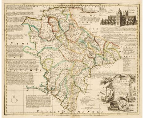
Devon. Bowen (Emanuel). An Accurate Map of Devonshire Divided into its Hundreds..., John Bowles & Son, Messrs. Bakewell & Parker, T. Bowles, H. Overton, T. Kitchin and J. Ryall, circa 1762, engraved map with contemporary outline colouring, originally published in 'The Royal English Atlas', slight creasing to the central fold, slight water staining to the lower margin, 415 x 495 mm, together with Cary (John). A New Map of Devonshire Divided into Hundreds..., 1807, engraved map with contemporary wash colouring, ovoid cartouche, compass rose and mileage scale, very slight staining, 500 x 560 mm, with Greenwood (C. & J.). Map of Devon from an actual Survey made in the years 1825 & 1826..., published Greenwood & Co. 1829, engraved map with bright contemporary wash colouring, inset map of the Isle of Lundy, calligraphic title, uncoloured vignette of Exeter Cathedral, compass rose and table of explanation, 645 x 715 mm, plus Teesdale (Henry). Devonshire, circa 1829, engraved map with bright contemporary wash colouring, table of reference to the hundreds, 355 x 430 mm, and Stockdale (John, publisher). A Map of Devonshire from the Best Authorities, 1805, map engraved by John Cary with contemporary outline colouring, 435 x 480 mm, with Harrison (J.). A Map of Devonshire Engraved from an Actual Survey, 2nd July 1789, uncoloured engraved map, large margins, old folds, some creasing, 340 x 470 mm, QTY: (6)
British Isles. Jansson (Jan & Ortelius Abraham), Insularum Britannicarum Acurata Delineatio ex Geographicis Conatibus Abrahami Ortelii, Amsterdam, circa 1652, an uncoloured historical map engraved by Pieter van den Keere, large margins, orientated to the east, compass rose and numerous rhumb lines, slight creasing, 395 x 510 mm, French text on verso, together with Mount (W. & J. & Page T., publishers), A New and Correct Chart of England, Scotland and Ireland, circa 1748, uncoloured sea chart orientated to the east, compass rose and numerous rhumb lines, light overall toning, 450 x 560 mm, with Merian (Matthaus). Magnae Britanniae et Hiberniae tabulae die Britannischen Insulen, circa 1646, uncoloured engraved map, inset map of the Orkney Islands, 275 x 355 mm, plus Mariette (Pierre). Novissima Descriptio Angliae Scotiae et Hiberniae, circa 1650, uncoloured engraved map, slight creasing, 370 x 490 mmQTY: (4)NOTE:The first described item. R. W. Shirley. Early Printed Maps of the British Isles, 1477 - 1650, number 522 (but slightly later state).
Liverpool. Bennison (Jonathan), A Map of the Town and Port of Liverpool with the Environs including Seacomb, Woodside, Birkenhead, Tranmere &c. from actual survey, Liverpool, Sept. 1835, large map, engraved by John Dower, with contemporary outline colouring, sectionalised and laid on later linen, calligraphic cartouche, compass rose and table of reference, slight spotting and staining, old library stamp to the upper right corner, marbled endpapers, 1280 x 1780 mm, contained in a contemporary burgundy morocco gilt book box with a morocco gilt label of the Liverpool Dock Office to the upper siding, spine a little faded, slight wear to extremitiesQTY: (1)
Birmingham. Beilby, Knott & Beilby (publishers), To the Right Honourable William Earl of Dartmouth, Viscount Lewisham &c. &c. the Zealous Promoter of the interests of the Town and Liberal Patron of its Public Institutions, This Map of Birmingham engraved from a minute Trigonometrical survey, made in the years 1824 & 1825, is with permission dedicated..., J. Pigott Smith, Surveyor and Engineer, Birmingham, March 25th 1828, uncoloured large engraved map, sectionalised and laid on linen, inset plan of the town of Birmingham in the year 1731, large calligraphic cartouche, compass rose and mileage scale, slight staining and offsetting, edged in green silk which is frayed with some loss, short splits along old folds, 1380 x 1290 mm, marbled endpapers, contained in a contemporary marbled card slipcase, case worn and frayedQTY: (1)NOTE:An uncommon large scale map of Birmingham.
[SIGNED COPIES] Sarah Ferguson Duchess of York Her Heart for a Compass 2021, inscribed by the author “for you Andrew, I know you will recognise yourself in this, who could forget ??? Sarah, The Duchess of York”. The Accident by Ismail Kadare 2020 signed. An Eagle in the Snow by Michael Morpurgo 2015 signed. Gods & Beasts by Denise Mina 2012 signed and two other signed (6)
PIETER VAN DEN KEERE coloured antiquarian map entitled in cartouche 'Wales', showing the whole of Wales and a small section of Ireland, with inset scale of miles, compass and other illustrations, circa 1620s, 8 x 12cmsProvenance: the Welsh art collection of award-winning television producer, the late Pat Llewellyn (1962-2017), by descentComments: framed and glazed, ready to hang
THE RED COMPASS STOCKBOOK HOUSING AN ECLECTIC COLLECTION OF GB AND BRITISH COMMONWEALTH MINT AND USED STAMPS. VALUE LIES IN THE SECTIONS : HONG KONG, NEW ZEALAND, MALAYAN STATES, AUSTRALIA, BRITISH CENTRAL AFRICA, ZANZIBAR, MOROCCO AGENCIES, CANADA, INDIA & STATES PLUS VARIOUS ON LEAVES AT BACK OF BOOK. WELL WORTH CLOSE EXAMINATION
Early 20th century Goliath pocket watch, the enamel dial with Roman numerals denoting hours, seconds subsidiary dial at the half-hour mark, silver plated case, case diameter 65mm approx., a carved wooden Black Forest-style pocket watch stand, a Terrasse W Co military issue compass and an Ingersoll pocket watch
John Speed Hand-coloured engraved map "Shropshyre Described, The Sittuation of Shrowesbury Shewed with the Armes of those Earles and other Memorable things Observed", inset town plan of Shrewsbury, large strapwork cartouche and compass rose, framed and glazed, image size 39.5cm x 52cm Condition Report Map is original (17th century), possibly later hand coloured but looks contemporary. Can't tell if map is stuck down.
FOUR MASONIC ITEMS, to include a silver Irish Masonic past masters jewel suspended from ribbon, designed as a square and compass with suspended initial G in the centre, personalised engraving to the reverse for vacating the chair 1903, engraved clover decoration to the front, hallmark for Dublin 1902, with fitted case, with a further silver Masonic jewel for Old Bromsgrovian Lodge No.5743, personal engraving to reverse for retirement from chair 1964-1965, hallmark for Birmingham 1962, together with a Steward brooch for the Royal Masonic Institution for Boys 1969, a small Masonic stickpin and a costume jewellery cameo brooch
A GROUP OF CHILD'S GOLD AND SILVER JEWELLERY Comprising: a pair of adjustable bangles, marked 22k and 'KCL'; three small rings, variously marked; a larger ring set with a rose cut diamond; a small diamond pendant; an engraved Bagua pendant, marked 22k and 'LSH'; a novelty compass charm; four small pairs of unmarked earrings; a gold coloured bracelet or anklet with two bells, unmarked; an a silver flattened curb link bracelet, unmarked The bangles 4.5cm wide The gold coloured components 37.7g Provenance: Lot 3 to Lot 45 property of a local Peranakan family Condition: For a condition report or further images please email hello@hotlotz.com at least 48 hours prior to the closing date of the auction. This is an auction of preowned and antique items. Many items are of an age or nature which precludes their being in perfect condition and you should expect general wear and tear commensurate with age and use. We strongly advise you to examine items before you bid. Condition reports are provided as a goodwill gesture and are our general assessment of damage and restoration. Whilst care is taken in their drafting, they are for guidance only. We will not be held responsible for oversights concerning damage or restoration.
PORSCHE DESIGN by IWC Vintage "Kompass" seltene Herrenuhr, Ref. 3511. Aus 1994. Titan, Kompass mit Spiegel unter Klappdeckel. Automatik-Werk, gute Gangwerte, Protokoll anbei. Schwarzes Tritium-Zifferblatt mit Datumsanzeige, Tritium-Zeiger. Sehr guter Zustand, leichte Gebrauchsspuren an Gehäuse und Armband. Original Garantiekarte und Anleitung anbei, Kauf 04/1994. Durchmesser ca. 40,5mm ohne Krone, passend für Handgelenksumfang von ca. 22cm.| PORSCHE DESIGN by IWC Vintage "Compass" rare Men's watch, ref. 3511. From 1994. Titanium, compass with mirror unter hinged lid. Automatic movement, good working order, protocol enclosed. Black Tritium dial with date display, Tritium hands. Very good condition, light signs of wear on case and bracelet. Original warranty card and manual enclosed, purchase 04/1994. Diameter approx. 40.5mm without crown, suitable for a wrist size of approx. 22cm.

-
36562 Los(e)/Seite