36562 Preisdatenbank Los(e) gefunden, die Ihrer Suche entsprechen
36562 Lose gefunden, die zu Ihrer Suche passen. Abonnieren Sie die Preisdatenbank, um sofortigen Zugriff auf alle Dienstleistungen der Preisdatenbank zu haben.
Preisdatenbank abonnieren- Liste
- Galerie
-
36562 Los(e)/Seite


Los 53
A parcel lot of jewellery to include two agate set oval brooches, a carved hard stone compass suspended from a brooch pin, a heart shaped agate pendant, a silver link hinged carved agate bracelet (A/F), a white metal filigree floral brooch, a pair of glass cabochon clips with thistle decoration and a metal brooch agate set with floral motif, (8)


Los 143
AN EARLY 19TH CENTURY SUNDERLAND LUSTRE POTTERY BOWL, circular, transfer printed, painted and pink lustre lined, internally with three panels comprising A West View of the Cast Iron Bridge, the Sailor's Farewell and a sentimental verse and externally with The Mariner's Compass, West View of the Cast Iron Bridge and the Sailor's Tear, 23cm diameter; and a further example, externally decorated only, comprising a sentimental verse, a depiction of two sailors, seated, smoking and a representation of the Sailor's Farewell, 20.7cm diameter (2)


Los 757
AN ENGLISH BRASS 2 INCH REFRACTING TELESCOPE BY DOLLOND LONDON with mahogany tube, rack focusing, additional tube, screw cap, two objective lenses and tripod stand with compass joint, engraved Dollond LONDON, fitted mahogany case, early 19th century Mahogany tube with a number of minor old scratches and marks but the instrument complete and in basically good condition not restored or repolished. The lacquer probably original but very rubbed and darkened, the mahogany case with minor slit in the lid but in reasonably good condition not repolished retaining the brass key plate and one of the two hooks


Los 463
A WWI War medal to 2nd Lieut John Enos C Griffiths (Jack) 1893-1918 second Lieut Battalion Gloucestershire Regt. killed April 1918, together with his compass and framed photograph also similar photograph of his brother, a silver mounted cricket ball from 1910 Taunton School and his sport kit


Los 3
JAMES McCABE, ROYAL EXCHANGE, LONDON, No. 11810, A GEORGE III WATCH MOVEMENT with finely pierced and chased balance cock, the white enamel dial correspondingly numbered with Roman numerals and subsidiary seconds dial, contained in a later silver replacement hunter case, hallmarked London 1785, the silver oblong linked albert suspending an Aventurine inset compass fob and a swivelling bloodstone fob


Los 16
Hondius/Le Clerc, 1633 Orbis Terrae Novissima Descriptio ""This is the first of two world maps engraved by Jodocus Hondius for Parisian publisher Jean Le Clerc. The map is based on Rumold Mercator`s double-hemisphere map from 1587 (see Shirley #157), which in turn was based on his father`s great world map of 1569. The North Pole is depicted as a landmass surrounding a sea from which four rivers radiate and there is a well depicted Northwest Passage. There is a huge Terra Australis, and the lands of Maletur and Beach (from the travel account of Marco Polo) are noted along the coast in the vicinity of present-day Australia with a large island labeled Iava Minor located in the same region. Japan is shown in a kite-shaped configuration, with the fictitious Satyrorum insule (Satyr`s Island) shown above. Hondius updated Mercator`s map by eliminating the bulge in the southwest coast of South America and adding the islands of Queen Elizabeth at the southern tip. In addition, Hondius elongated New Guinea and added several islands to its east. The hemispheres are surrounded by an elaborate decorative border with an armillary sphere and 32-point compass rose tucked between the hemispheres. Hondius has balanced the title at top with one of his favorite quotations from the Psalms at bottom. The composition is completed with several diagrams in the corners, including two wind roses with the wind names in Dutch and Italian, a diagram of the phases of the moon, and a final diagram of the climatic zones. Le Clerc`s map was issued both separately and in editions of Mercator-Hondius atlases and Le Clerc`s own atlas (Theatre Geographique du Royaume de France). This is the third state, dated 1633, with the coastline of Terra Australis partially erased and without the line of small islands between New Guinea and South America. Blank verso."" 19.9"" W x 12.9"" H Nice impression and color on watermarked paper with good margins and faint damp stains in blank margins, just entering map border at far right and left.

Los 17
Blaeu, Willem 1640 Nova Totius Terrarum Orbis Geographica ac Hydrographica Tabula ""A magnificent map featuring a carte-a-figures border with allegorical representations of the sun, the moon, the five known planets, the four elements and the four seasons. Along the bottom are vignettes showing the seven wonders of the world: the Hanging Gardens of Babylon, the Colossus straddling the harbor at Rhodes, the Pyramids, the Mausoleum of Halicarnassus at Cairo, the Temple of Diana, the Statue of Jupiter and the lighthouse at Alexandria. Josua van Ende engraved this map, reducing it from Blaeu`s 1605 wall map for inclusion in atlases. Petrus Plancius` world map of 1592 was the main source of geographical information. The map is shown on Mercator`s projection with a massive Southern Continent attached to New Guinea, with the coastal names of Beach and Psittacorum regio noted from Marco Polo`s travel memoirs. North America has the westward bulge characteristic of the time, with the Strait of Anian noted. Korea is shown as an island and Japan is in a kite-like shape. The map itself is richly decorated with cartouches, sea battles, monsters and compass roses. Fourth state with Tierra del Fuego shown as an island and the date omitted from the lower cartouche on the right. Latin text on verso, published between 1640-43."" 21.6"" W x 16.2"" H A dark impression on watermarked paper with minor printer`s ink residue in the Barents Sea and expertly repaired centerfold separations at top and bottom.

Los 18
Hondius/Mariette, 1642 Nova Totius Terrarum Orbis Geographica ac Hydpographica Tabula The Hondius world map of 1617 was the prototype for a series of maps by French publishers who combined Hondius` geographical information with the more scientific border decorations from Boisseau`s map of 1636. The map depicts the discovery of the Le Maire Strait at the tip of South America. In North America, the St. Lawrence River runs nearly the entire width of the continent, terminating in a large lake not far from the infamous Civolo 7 citta (7 cities of Cibola). Hudson Bay is depicted after the work of Gerritsz. In Asia, Korea is shown as an island, the northern coast of New Guinea is more properly located and there is a large Terra Australis Incognita with Boach named in the region of the Australian continent. The surrounding engravings include a pair of celestial charts, circular diagrams containing the compass points, the names of the winds, the climatic zones, the heavenly orbits and a thirty-year calendar. The map is richly adorned with a variety of decorations including three cartouches, two featuring native figures, numerous sailing ships, sea monsters, flying fish and a depiction of Neptune. This is the first state with Mariette`s imprint. Although dated 1642, this was likely published in the 1653 edition of Mariette`s Theatre Geographique de France. 22"" W x 15"" H A fine impression, issued folding and now flattened on watermarked paper with light soiling. There are professional repairs to a small hole at far left as well as a few short separations and tiny holes along the folds. The left and right margins have be

Los 34
Bellin, Jacques Nicolas 1748 Essay d`une Carte Reduite Contenant les Parties Connues du Globe Terrestre... Early issue of this fine large world chart on Mercator`s projection decorated with a large title cartouche and two compass roses. North America is shown with a very pronounced River of the West connecting through a series of rivers and lakes from Lake Superior to the Pacific - representing the elusive Northwest Passage. The Russian discoveries in the North Pacific are not yet shown, although there is a note about the voyages of 1743. Australia is labeled Nouvelle Hollande with Terre de Diemen and Nouv. Guinee both linked to the mainland. New Zealand is only partially formed and there are numerous islands in the Pacific. On four sheets, professionally joined. 25.5"" W x 18.9"" H Issued folding, now pressed flat, on watermarked paper with faint offsetting and a few spots scattered throughout the map. The left margin is very narrow with a portion trimmed to the neatline.

Los 49
Hondius/Bertius, 1618 Description de la Terre Soubs-Australe This handsome miniature map is one of the first to focus solely on the South Pole. It depicts a large Magallanica Sive Terra Australis Incognita incorporating Terra del Fuogo, Beach Provincia, Psittacorum Regio, and Promontorium Terrae Australis. The large landmass is separated from South America by the Strait of Magellan, and almost joined to Nova Guinea, with the Salomon Islands depicted nearby. The map is handsomely adorned with a fierce sea monster, a sailing ship, and two compass roses orienting north away from the South Pole. French title page on verso. 5.3"" W x 3.8"" H A nice impression on watermarked paper with minor marginal soiling and light text show-through.
![Cary, John 1800 [12 Inch Globe] Carys New Terrestrial Globe Delineated from the Best Authorities
""This is a stu](http://lot-images.atgmedia.com/SR/36385/2901770/53-201425154949_468x382.jpg)
Los 53
Cary, John 1800 [12 Inch Globe] Carys New Terrestrial Globe Delineated from the Best Authorities ""This is a stunning 12"""" terrestrial globe produced by the famous Cary brothers at the beginning of 19th century. The globe is supported by a full graduated brass meridian and has a very ornate and detailed horizon ring that shows compass directions, days and months of the year, zodiac signs, and degrees of amplitude and azimuth. It is raised on a mahogany stand with three legs. The globe is composed of 12 hand colored gores in shades of olive and cream. Complete with brass hour ring at the North Pole and a large analemma in the Pacific Ocean. Total height is 24 inches. The globe shows excellent detail of the voyages of many famous navigators including Cook, Vancouver, La Perouse and Pickergill. Geographically, in North America the United States is confined to east of the Mississippi River and the west shows very little detail. The southern half of Africa is labeled as """"Unknown Parts"""". A circular title cartouche reads """"Cary`s/New/Terrestrial Globe/Delineated/From the best Authorities extant;/Exhibiting the Tracks of/Captain Cook,/and the New Discoveries made by him/ and other Circumnavigators./London."""" The distributor`s imprint, R. Spear of Dublin, replaces that of Cary at the bottom of the cartouche. John Cary and his brother, William, were regarded as the finest English globe makers of the late Georgian period."" 17"" W x 24"" H This beautiful globe with original color has benefited from professional restoration. It has been revarnished and shows the typical scattered foxing and staining which is typical for a globe this age. Some of the foxing has been covered with touch-ups o

Los 98
Moll, Herman 1701 The English Empire in America, Newfound-Land, Canada, Hudson`s Bay. &c. in Plano This fascinating map of English possessions in North America stretches from Cuba to the southern tip of Greenland. There is good detail throughout the eastern seaboard, with many rivers named and important settlements and cities such as Jamestown, Plymouth, Boston, Baltimore, Philadelphia, and Charleston located. The boundaries of Virginia extend north to Lake Erie, and Pennsylvania`s northern border nearly reaches the St. Lawrence River. A note pointing out The 5 Nations of the Iroquois spans from Virginia to Montreal. The St. Lawrence River, Hudson`s Bay, Lake Ontario, and Lake Erie all appear in a roughly accurate configuration. A compass rose capped with a fleur-de-lys and radiating rhumb lines adorns the Atlantic, referred to here as the Sea of the English Empire. Moll`s System of Geography was essentially a larger version of Thesaurus Geographicus of 1695. The additional maps included in System of Geography were stamped ""NEW,"" as seen here below the title cartouche. English text on verso. 7"" W x 8.5"" H A fine impression with light show-through of text on verso.

Los 113
Bellin, Jacques Nicolas 1756 Plan du Port et Ville de Louisbourg dans l`Isle Royale This is the second state of this plan of Louisbourg, the French fortified settlement on Cape Breton Island. War broke out between France and England in 1744, and a large number of maps were produced to describe the areas involved. The French lost Louisbourg to a determined British army, but the treaty of Aix-la-Chappelle returned Louisbourg to the French in 1748. By 1758 Louisbourg was once again besieged by the British, and in 1760 the fortress was leveled. Published only four years prior to its destruction, the plan shows the harbor of Louisbourg in the southeast portion of the island in great detail. A large compass rose topped with a fleur-de-lis in the harbor orients the map with the north to the upper right corner. The German title appears below: Grundriss des Hafens und der Stadt Louisbourg oder Ludwigsburg auf der Koenigs-Insel. 11.1"" W x 7.6"" H Just a hint of soiling in blank margins.

Los 126
Spilsbury, J. 1761 A New Map of North America from the Latest Discoveries This is the uncommon first state, not the 1763 edition from London Magazine, of this fine map noting the colonial possessions in North America eastward from Texas to the Atlantic coast. It shows early settlements, forts, Indian villages, and tribal territory. The colonies have boundaries extending past the map`s western border. Various treaty and charter boundaries are shown. Earl Granville`s Property stretches from the Atlantic west to beyond the Mississippi River. In Florida, a line from Fort St. George to St. Mark delineates the Limits Stipulated in 1738 and below, nearly to Cape Canaveral, are the Bounds of Carolina by Charter of 1665. The fishing banks off Canada are prominently outlined. The map is enhanced by a delicate title cartouche and fancy compass rose. 14.9"" W x 10.9"" H A nice impression on watermarked paper, issued folding, now pressed flat, with one short fold separation entering less than 0.75"" into the image that has been closed on verso with archival materials. There is also a tiny edge tear just breaching the neat

Los 192
Hondius, Jodocus 1619 Virginiae Item et Floridae Americae Provinciarum, Nova Descriptio This stunning map was compiled from two of the most important source maps of the early colonial period: John White`s Virginia and Jacques le Moyne`s Florida. Hondius` map became the prototype map of the region for the first half of the 17th century and continued to influence the cartography of the region until the middle of the 18th century. Largely due to the enormous success of Hondius` Atlas, Le Moyne`s erroneous depiction of a large inland lake (Lacus aquae dulcis) from which the R. de May (St. John`s River) flows in a southeasterly direction was popularized. Chesapeake Bay, here called Chesepioock Sinus, and the area south towards C.S. Romano Hispanis are shown in their White delineations. The Indian villages of Paquiwok, Croatoan, and Wococon are named in the Outer Banks and several others along the Albemarle and Pamlico Sounds. The map is extensively decorated with depictions of Indian villages incorporated in the title cartouche, a Floridian king and queen and Virginian natives in a canoe taken from De Bry, wildlife including a wild turkey, ships, sea monsters and a superb compass rose. French text on verso. 19.1"" W x 13.5"" H A nice impression with full original color, light overall toning, minor color offsetting, and a crease adjacent to centerfold.

Los 203
Gibson, John 1763 A Map of the New Governments, of East & West Florida This map was published in November 1763 just a few weeks after the British acquisition of Florida at the conclusion of the French and Indian War. The region was divided into two British provinces, East and West Florida. The division was along the Apalachicola River, the boundary line for the Royal Proclamation of 1763 that extended from the Ohio River to Florida along the watershed of the Appalachian and Allegheny Mountains. The Proclamation was designed to reduce confrontation between Indians and colonists by outlawing English settlement west of the line. East Florida encompassed primarily the Florida peninsula; West Florida included the Gulf Coast region from the Apalachicola River to the Mississippi River south of 31° of latitude. The map locates many settlements, swamps, and rivers. Southern Florida is split by many waterways, giving the appearance that it`s made up of numerous small islands. A large inset, Plan of the Harbour and Settlement of Pensacola, provides good detail of the Bay of Sta. Maria Galres (now Pensacola Bay) complete with soundings and a compass rose. 9.9"" W x 7.6"" H Issued folding, now pressed flat, with some faint soiling.

Los 246
Weld, Isaac 1798 Plan of the City of Washington This is a reduced and simplified version of Ellicott`s plan of 1792. Washington is bordered by the Potomack (Potomac) River and the Eastern Branch, now the Anacostia River. Georgetown, at the left and northwest of Rock Creek, is separately labeled. Reedy Branch and Tiber Creek are shown to the north outside of the street pattern. A few major buildings including the Capitol and the Presidents House are labeled; others are merely outlined. The proposed landscape design for the Mall is shown with some detail. Near the upper right is an eight-pointed compass indicator surmounted by a fleur de lis. Published by J. Stockdale. 8.5"" W x 6.8"" H Light toning and soiling along sheet edges, else fine.

Los 247
Carey & Lea, 1822 Geographical, Statistical, and Historical Map of the District of Columbia This map of the nation`s capital is on a full folio sheet (20.6 x 16.6"") with surrounding text describing boundaries, climate, population, nearby towns, commerce, government, and history. Washington, Alexandria, and Georgetown are shown as plans, and several waterways and roads are identified. A compass rose capped with a fleur-de-lis indicates that the north is oriented to the upper left and an arrow indicates the direction of the Potomac River. Engraved by Young and Delleker. 10.5"" W x 10.8"" H Original outline color with centerfold separations at top and bottom that do not enter the map image and have been closed on verso with archival tape.

Los 265
U.S. Government, 1827 Plan of the Front Part of the City of New Orleans, in 1818 An uncommon map of the front of the early city of New Orleans, surveyed by Gilbert Joseph Pilie, and published in 1827. The map shows the custom house, water works, Chartres Street, and the levees along the Mississippi River. At bottom, a compass rose orients the map with north toward the upper right corner. 22"" W x 7.3"" H Issued folding with good margins and a light damp stain along one fold.
![1925-34 [Lot of 3] Cape Cod [and] [Untitled - Map of Cape Cod] [and] [Untitled - Map of Cape Cod] ""A. Cape Cod, b](http://lot-images.atgmedia.com/SR/36385/2901770/276-201425154142_468x382.jpg)
Los 276
1925-34 [Lot of 3] Cape Cod [and] [Untitled - Map of Cape Cod] [and] [Untitled - Map of Cape Cod] ""A. Cape Cod, by Kenneth E. Morang, dated 1934, black & white (19.4 x 19.4""""). A graphic map of Cape Cod drawn by Kenneth E. Morang and issued by the Cape Cod Chamber of Commerce. The map shows points of interest in Cape Cod and includes many historical notes, including a point off of Eastham where a German submarine fired a shot inland, """"the only shot to land on American soil in the World War."""" The seas are filled with ships, and a sacred cod, complete with halo. The key lists roads by types, including those """"`particularly recommended for quaintness and charm."""" The sides are filled with tourist related information. The map is further embellished with fancy ribbon-style titling and a large compass rose. The map self-folds into a mailer with the chamber`s address at top left. Condition: Light toning with several small fold separations. A previous owner has drawn """"approximate town lines"""" in blue ink throughout the map. (B) B. [Untitled - Map of Cape Cod], by Cape Cod Chamber of Commerce, circa 1934, printed color (12.8 x 12.8""""). This small promotional map of Cape Cod lists the numerous hotels and golf courses in the area. A panel of text to the right of the map shows the driving distances between various cities. Folds into tan wrappers with 8 pp. of text. (4.1 x 7.1""""). Condition: There is one small separation where the map folds into the wrapper. (B+) C. [Untitled - Map of Cape Cod], by Cape Cod Chamber of Commerce, circa 1925, printed color (12.8 x 12.8""""). This is the same map as above but folds into pictorial wrappers with 15 pp. of illustrations showing the history and beauty of the area (4.1 x 8.9""""). Condition: The map is clean and bright but is secured to the brochure by two small rusty staples. (B+)"" "" W x "" H See descriptions above.
![Thackara, James 1797-98 A Map of Pennsylvania Delaware New Jersey & Maryland, with the Parts Adjacent [with 2 volumes] T](http://lot-images.atgmedia.com/SR/36385/2901770/304-201425154231_468x382.jpg)
Los 304
Thackara, James 1797-98 A Map of Pennsylvania Delaware New Jersey & Maryland, with the Parts Adjacent [with 2 volumes] The History of Pennsylvania, in North America... ""This rare map covers an area from southern New York to Central Virginia and displays rudimentary topographical detail of the Allegheny Mountains and Chesapeake Bay as well as towns, settlements, roads and rivers. Delaware is also labeled as Territories of Pennsylvania. A simple compass rose adorns the Atlantic Ocean. The map was issued in Robert Proud`s two volume The History of Pennsylvania. Robert Proud was born in Yorkshire, England and moved to Philadelphia in 1759. He started his career there as a school teacher but later went into seclusion to write on various subjects. Proud was a staunch Loyalist and his beliefs came through in his writings. Even his most famous work, The History of Pennsylvania, was widely considered unsuccessful and not widely distributed due to its loyalist bias at a time of great American pride and enthusiasm. 1025 pp. of text including a preface (16 pp.), introduction (149 pp.), main text (694 pp.), appendix (146 pp.) and index (20 pp.). Includes a frontispiece of William Penn in Volume I. Octavo, rebound in red buckram with gilt title on spine."" 14.3"" W x 12.3"" H The map is issued folding (loose) with light offsetting and toning. There is a binding trim at right and an associated tiny binding tear confined to the blank margin that is closed on verso with archival tape. Contents are very good with light toning an
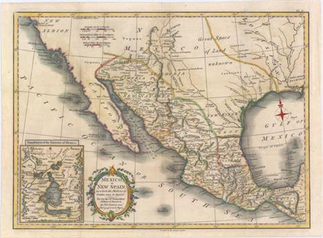
Los 338
Kitchin, Thomas 1780 Mexico, or New Spain; in Which the Motions of Cortes May Be Traced This is a very attractive map of the American Southwest and Mexico. California is labeled New Albion with no detail outside of a few coastal place names. The region of present-day Arizona and New Mexico is well delineated with numerous Indian villages and the locations of missions. The area from New Mexico to Louisiana is named as ""Great Space of Land Unknown."" The small Texas settlement of Cenis is near the New Kingdm. of Leon. An inset shows Mexico City on the large Lake of Mexico. Finely engraved with a decorative title cartouche and compass rose. This map was originally published in 1777, this being a later edition by T. Cadell. 15.3"" W x 11.2"" H Issued folding, now pressed with light soiling. A binding trim at top right has been replaced with old paper to accommodate framing.

Los 370
Fer, Nicolas de 1702 Les Isles de l`Amerique Connues sous le Nom d`Antilles, ou Sont les Isles de Cuba, St. Domingue et Jamaique les Lucayes, les Caribes, et celles du Vent There are a number of interesting historical and geographical notes on this map of the Caribbean. The map extends north to the Bahamas and the tip of southern Florida and encompasses the eastern shore of the Yucatan, parts of Central America, Panama and the northwest coast of South America. Between Florida and Cuba and the Bahamas, a reference to the Gulf Stream notes that is always flows north. Engraved by Herman van Loon with a handsome title cartouche and a small central compass rose. 13.2"" W x 8.8"" H Watermarked paper with some light damp staining confined to the lower blank margin.

Los 379
Delisle/Covens & Mortier, 1730 Carte de l`Isle de Saint Domingue Dressee en 1722 pour l`Usage du Roy sur les Memoires de Mr. Frezier This is an important map of Hispaniola and the Turks & Caicos Islands. When initially published in 1722 by Delisle it was one of the first to depict the island`s true contours following Frezier`s important map of the island. The chart provides excellent detail of the three districts showing mountains, roads, towns, ports, plantations, sugar works and navigational hazards. Decorated with a large title cartouche and compass rose. Latin title above, ""Insulae S. Dominicae Tabula Accuratissima."" 24.1"" W x 18.6"" H Original color with a hint of toning along sheet edges.
-
36562 Los(e)/Seite