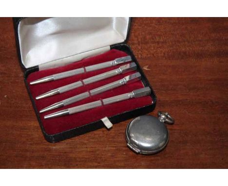
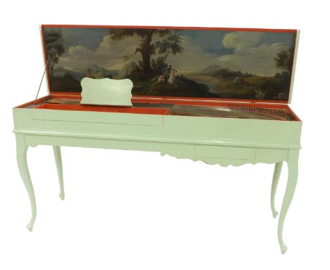
36562 Preisdatenbank Los(e) gefunden, die Ihrer Suche entsprechen

Verfeinern Sie Ihre Suche

Jahr

Sortieren nach Preisklasse
  • Liste
  • Galerie
  • 36562 Los(e)
    /Seite

Los 161

*Derbyshire. Saxton (Christopher & Hole William), Universi Derbiensis Comitatus qui olim Coritanorum suit Descriptio, circa 1610, hand coloured engraved map, large strapwork cartouche and compass rose, slight creasing, 285 x 310 mm, mounted, framed and glazed, together with, Saxton (Christopher & Hole William), Staffordiae Comitatus pars olim Cornauiorum, [1637], hand coloured engraved map, 275 x 375 mm, mounted, framed and glazed, with, Moll (Herman), Staffordshire, [1724 or later], hand coloured engraved map, horizontal borders decorated with antiquities, 315 x 185 mm, mounted, framed and glazed (3)

Los 165

Estate Plan. A Survey of Several Estates in the County of Worcester belonging to Sr. William Blount Bart. taken by R.Hill, 1768, large pen, ink and watercolour estate plan on vellum, elaborate cartouche and scale of chains, compass rose, slight creasing, 815 x 995 mm (1)

Los 723

BRASS COMPASS. Brass compass named Stanley of London, D: 6,5 cm

Los 726

BRASS COMPASS. Brass compass named Ross of London, D: 6 cm

Los 729

DESK COMPASS. Wooden and glass desk compass, D: 10 cm

Los 733

BRASS COMPASS. Brass compass named T&G Co Ltd, D: 6,5 cm

Los 738

BRASS COMPASS. Brass compass named T&G Co Ltd, D: 6,5 cm

Los 1694A

Assorted spirits to include, Croft Particular, Medium Dry Amontillado Sherry, one bottle (boxed); Glenmorangie, Highland Single Malt Scotch Whisky, one bottle (boxed); Finest Reserve Port, Douro Region, one bottle; Commandaria, St Anastasia Liqueur Wine, one bottle (boxed); Croft Original Sherry, one bottle (boxed); Compass Amontillado Medium Golden Sherry, one bottle, six bottles in total

Los 8

NAUTICAL SHIPS COMPASS IN GIMBLE DIAL 16CM DIA C.1900

Los 451

A brass cased field compass, inscribed 'T.G. Co. Ltd' to base, 2½'' diameter

Los 114

George JohnstonChart of the Entrance to Strangford Lough This is an isolated chart, surveyed and presumably published by George Johnston in 1755. The first state gives no engraver's name, but the second state gives it as John Ridge of Dublin.It shows the entrance to Strangford Lough, with the mainland from Gunn's Island to Castle Ward, and the Ards coast from Millin Bay round Ballyquintin Point to Ballywhite Bay. It gives soundings and anchorages but little inland detail. The title in the top right corner reads Strangford River from an Accurate Survey by George Johnston of Portaferry Pilot 1755, and is depicted on a shell supported by a sea-god. The cartouche is very similar to that of Greenvile Collins' title page for his Great Britains' Coasting Pilot, except that the figure is facing left instead of rig ht. There are three ships alongside this figure, and some houses, castles and churches are illustrated. In the middle left is an Explanation or key to the symbols and depth markings. In the lower left corner is A Scale of Two English Miles 2[= 119 mm.]. There is one compass rose showing north to the top, but no scale of latitude or longitude. The frame consists of two parallel lines. 295 x 525 mm.

Los 119

Murdoch Mackenzie Chart of East Ireland and the Irish Sea This is the 6th chart in Vol. II of A Maritime Survey of Ireland, published in London in 1776. It is printed on five sheets joined together and has Chart VI in the top right corner.It shows the east coast of Ireland from Greenore, county Wexford, to Coleraine, county Londonderry, and the west coast of Great Britain from mid-Wales to the Mull of Kintyre. The title is in a rococo frame in the left centre, with ships at the quayside, a globe and books, and the symbols of England, Scotland, Ireland and the Isle of Man (rose, thistle, harp and three legs). It reads A General Chart of the Irish Channel by M. Mackenzie senr.. Below the title cartouche is (unframed) A Scale of 10 Leagues, 20 to a Degree of the Meridian 10 [= 161 mm.]. Between the two is Engrav'd by G Terry, 62, Paternoster Row. and below the chart frame is Published as the Act directs Novr. 26th 1775. There are three compass roses showing north to the top, with magnetic variation dated 1760, and scales of latitude on each side. 955 x 1,165 mm.

Los 12

Pieter Goos (1615-1675)A Chart of Ireland and the Irish Sea “Paskaarte om Achter Yrlandt om te Zeijlen van Hitland tot aen Heijsat Nieuwlycx Utgegeven t`Amsterdam bij Pieter Goos op het waater in De Verguide-Zee-Spiegel. Anno 1666.” This is identical with the previous state but two small compass roses have been added in the sea to the right of centre, pointing to magnetic north. (1668). Verso blank. 550 x 445.

Los 122

William MorrisChart of St. George's Channel This is a loose chart, considerably modified from Lewis Morris's chart of 1748 covering the same area, which was published in 1800.It shows the Irish coast from Carnsore Point, county Wexford, to Lambay Island, county Dublin, as well as the British coast from north Somerset and Cardiff to Formby, Lancashire. The title in the centre right, unframed, reads To the Right Honourable the Lords Commissioners for executing the Office of Lord High Admiral of Great Britain, Ireland, &c. This Chart of St. George's Channel &c. Surveyed under their Lordships' direction by the late Lewis Morris Esqr. which is now extended by an Actual Survey (the whole Corrected & much Improved) from Liverpool to Cardiff in the Bristol Channel; is by Permission most respectfully dedicated by their Lordships' obedient humble servant William Morris. Below the lower margin is Published 25th Novr. 1800 by Willm. Morris. Engraved by Wm. Simpkins, Clements Inn. Below this is an explanation of symbols and below it, unframed, is A Scale of Leagues 10 [= 147 mm.]. There is one compass rose showing north to the top and there are scales of latitude and longitude (W. from London) along all four borders. 780 x 885mm.

Los 123

William MorrisChart of Dublin BayThis is the last chart in William Morris's Plans of the Principal Harbours, Bays & Roads in St. George's and the Bristol Channels, which was first published in 1748 by his father, though this chart only appeared in this edition of 1801.It shows the Irish coast from Five Mile Point, county Wicklow, to Lambay Island. The title is unframed in the top right corner and reads A Plan of the Bay and Harbour of Dublin by William Morris and an imprint below the lower border reads Publish'd by W. Morris 25th Novr. 1800. Simpkins fe.. In the lower right corner is A Scale of Miles 4 [= 50 mm.]. There are soundings along the whole coast and round the sandbanks, as well as signs for the currents and lighthouses. One compass rose shows north to the top right. 320 x 187 mm.

Los 126

John Rocque (1705-1762)Chart of Dublin Bay and Plan of Dublin and Environs This is on four sheets, the bottom left sheet of which can be regarded as a town-plan of Dublin and the remainder as a map of the surroundings and a chart of Dublin Bay. The town-plan is a later state of No. 2 described in the Introduction, with the addition of river depths and the outer administrative boundary of the city.It shows the coast from Scotchman's Bay, Dalkey, northwards to include all of Howth Head, and inland to the centre of Phoenix Park and Finglas. The title is printed above the top of the two northern sheets and reads A Survey of the City Harbour Bay and Environs of Dublin on the same scale as those of London Paris & Rome By John Rocque Chorographer to his Royal Highness the Prince of Wales. Plan de la Ville, Havre, Baye & Environs de Dublin sur la meme Echelle que ceux de Londres, Paris & Rome par Jean Rocque chorographer du Roi avec des additions jusq a l'année 1773 par Mr Bernard Scalé. In the top left, in an irregular frame with the royal arms, is the dedication To His Royal Highness Prince Edward This Plan is most humbly inscribed by His Most Obedient Humble Servt. John Rocque. Below the left half of the frame are four scales: A Scale of an Irish Mile 320 Perches [= 168 mm.] A Scale of Yards 1000 [= 83 mm.] Echelle de Toises 500 [= 93 mm.] A Scale of an English Mile 320 Perches [= 132 mm.]. Alongside the scales is Published according to Act of Parliament and J.J. Perret Sculpt. Below the right half of the frame is an Explanation of the many symbols of boundaries and types of land use on the map. The bay has an indication of sand-banks and coastline with many soundings and 75 ships extending up the river Liffey. There is a decorative compass indicator of fish, nets and cornucopia showing true and magnetic north to the top left.There are three insets in the top left corner:1. Kildare House (120 x 210 mm.) showing the house and frontage on to Kildare Street, with various types of carriages arriving.2. The Barracks (120 x 208 mm.) with ladies and gentlemen strolling in front.3. The Royal Hospital (105 x 133 mm.) at Kilmainham, viewed from across the river.There is also an inset in the bay (195 x 197 mm.), depicted as if on a sheet, showing Dublin Anno 1610 Dublin comme il etait en 1610. The plan is flanked by two notes The Figures of the surroundings are Dotted thus . to distinguish them from those of the References. this Plan is Copyed from that Taken in 1610 and the Spelling the Same as at that Time. There are 69 numbers and a key for streets and buildings. Four sheets when joined. 1,395 x 1,010 mm. (4) For a full description see Abl Printed maps of Dublin R2. 1-4

Los 129

Ralph William Seale 1732-1775 II The Irish Sea This occurs in The Universal Magazine of 1757 (Vol. 21, opposite p. 49.)It shows a similar area to the previous chart except that it omits the west coast of Ireland. There are fewer markings round the coast, but there are again the rhumb lines, without soundings. The title in the lower left corner in an ornate scalloped frame, reads A New and Accurate Map of the Parts of England, Scotland & Ireland, Bordering on St. George`s Channel, &c. Below the frame is Univers. Mag. J. Hinton, Newgate Street and below the right corner of the frame is R.W. Seale del. et sculp. There is no scale of length, but latitude and longitude west from London are marked along all four sides, and there is one compass rose. 265 x 365 mm.

Los 130

John Seller 1634-1697(i) Chart of the South-East Coast of Ireland (ii) Chart of the South Coast of Ireland These two charts were printed from separate plates (a above b) on one page of The English Pilot, Southern Navigation (1672) and the Atlas Maritimus. The top half can be found on a separate sheet, but when printed together, the lower edge of the upper plate is omitted, reducing the total height by about 15 mm. from the above figures.(i) This shows the coast from south of Waterford to Kilkeel. It is entitled in a cartouche of strap-work in the top-centre A Chart of the East side of Ireland, from Waterford to Carlingford, shewing all the havens, Bayes, harbours, sands, depths and dangers, on the said Coast newly corrected and Published by Iohn Seller. And are to be sold at the Signe of the Mariners Compass at the Hermitage Stayres in Wapping. There are three compass roses showing north to the right, and one ship, but no scale of latitude or longitude. The scale in the top right corner reads A Scale of English leagues 20 in one degree 10 [= 132 mm.]. 545 x 245 mm.(ii) This covers the south coast of Ireland from Cape Clear to Waterford. It is entitled in a cartouche of strap-work and fruit, in the top left corner A Discription of the West side of Ireland from Cape Clere to the River of Waterford, shewing all the Roads and Harbors on the said Coast, newly Corrected by Iohn Seller. And are to be sold at his Shop, at the Signe of the Mariners Compass at the Hermitage stayrs in Wapping. Note that the title mentions the west coast for what is really the south coast. There is one compass rose showing north to the top, and one ship, but no scale of latitude or longitude. The scale in the lower right corner reads A Scale of English Leagues 20 in one degree [10 = 132 mm.]. 545 x 215 mm.

Los 131

John Seller (1634-1697)(i) Chart of the North-West Coast of Ireland(ii) Chart of the West Coast of Ireland(iii) Chart of the South-West Coast of Ireland The two upper charts are side by side with an irregular border, on one plate. The third chart, on one plate, forms the lower half of the page in The English Pilot, Southern Navigation (1672) and the Atlas Maritimus. As with chart I, part of both plates is omitted to allow them to be printed on the same page.(i) This shows the coast from the Bann mouth to Killala Bay. In the top right corner is A Scale of English Leagues, 20 in one Degree 11 [= 92 mm.]. Below this is the title A Description of the North Coast of Ireland between Banhaven and Cabo Moye, shewing all the Bayes, havens and harbors, on the said Coast newly corrected by Iohn Seller. Both are in double-lined rectangular frames. There are two half compass roses showing north to the left, but no scale of latitude or longitude. 545 x 245 mm.(ii) This chart is separated from the above by a straight and curved border and shows the west coast of Ireland from Killala Bay to the mouth of the Shannon and Limerick. The title is in the top centre of the page in an oval frame and reads A Chart of the West Coast of Ireland, between Cabo Moye and the River Shannon, shewing all the Bayes, Roads, havens and harbors. Newly corrected by Iohn Seller, and are to be sold at his Shop at the Signe of the Mariners Compass at the Hermitage stayres in Wapping. In the lower right corner there is A Scale of English Leagues, 20 in one Degree 13 [= 110 mm.]. There is one half compass rose showing north to the right, but no scale of latitude or longitude. 545 x 245 mm.(iii) This shows the coasts of Kerry and West Cork and is entitled in the top right corner A Chart of the Southwest side of Ireland, from Cape Cleare to the River Shannon, Describeing all the Bayes, havens, Roads and Harbors one [sic] the said Coast laid downe acording to their true Courses and distances, newly corrected and Published by Iohn Seller at the Hermitage stayres in Wapping. In the lower right corner there is A Scale of English Leagues 20 in one Degree 10 [= 132 mm.]. There is one compass rose showing north to the right, and one ship, but no scale of latitude or longitude. 540 x 235 mm.

Los 134

John Seller (1634-1697)Chart of Ireland and the Irish Sea This chart does not appear in the 1690 edition of The English Pilot, Southern Navigation, and is first seen in the 1701 edition. Three different plates were made, each occurring in two distinct states. The chart was replaced in an edition of c. 1769. It also occurs on its own in the Atlas Maritimus Novus or New Sea-Atlas by Mount and Page and in later editions of The English Pilot, Third Book.It shows all Ireland and the Irish Sea, with the British coast from Cornwall to the Mull of Galloway. The Ards peninsula and Island Magee are shown as separated from the mainland. The title (unframed) in the lower right corner reads A Chart of the Coasts of Ireland and Part of England. Below this is a scale of English and French Leagues 20 [= 80 mm.]. There is one compass rose showing north to the top and there are scales of latitude at each side. This edition from 1743. 555 x 445 mm.

Los 134A

John Seller (1634-1697)Chart of the South-East Coast of Ireland This chart appears first in Seller's The English Pilot, Southern Navigation of 1690, and it was unchanged in editions up to 1715. Later editions used new plates.It shows the coast from Waterford to Dalkey and has no title. The scale in the lower centre reads A Scale of English and French Leagues 20 in a Degre 5 [= 102 mm.]. There is one compass rose, with 16 points, showing north to the right, and there are a scales of latitude at top and bottom. This edition from the first English plate without title or insert. 535 x 440 mm.

Los 151

William HeatherChart of the St. George's and English Channels The dedication is unframed in the top centre and reads To the Right Honorable the Master, Wardens and Elder Brethren of the Trinity House this Chart of the English Channel Is most humbly dedicated by their obedient Servant William Heather. This was first produced as a separate chart in 1794 on three sheets which may be joined together. A new edition was printed in 1805.It shows the Irish coast from county Clare to Wexford, the British coast from Barmouth to Yarmouth and Europe from Britany to Haarlem in the Netherlands. There are detailed soundings round the coast and in the open sea, as well as tide and current marks and notes on the sea bottom. Below the frame is the imprint Published as the Act directs, July 12th 1794 by W. Heather, at the Navigation Warehouse, No. 157 Leadenhall Street, London. The navigational route through the English Channel is marked by a hand and two ships on the left sheet and two further ships on the middle sheet. There are scales of latitude and longitude east and west from London on all four sides, as well as three coastal profiles in the top centre. Magnetic variation on the left sheet is dated 1794 and there are four compass arrows showing north to the top as well as four ships. (1,890 x 775 mm.).There are six insets in the right sheet, each with one compass arrow showing north to the top:1. (142 x 345 mm.) entitled Portsmouth, with a Scale of Miles 5 [= 30 mm.].2. (100 x 120 mm.) entitled Sketch of the Situation of The Owner's Light by order of the Trinity House, 1794.3. (235 x 125 mm.) entitled Dartmouth, with a Scale of half a Mile 1/2 [= 45 mm.].4. (175 x 175 mm.) entitled Falmouth, with a scale of One Mile [= 30 mm.].5. (175 x 165 mm.) entitled Plymouth, with a scale of One Mile [= 30 mm.].6. (315 x 192 mm.) entitled Downs and Margate, with a Scale of Miles 3 [= 41 mm].1,890 x 775mm

Los 152

William HeatherChart of the North Coast of Ireland The title is in a circular frame in the centre and reads A New Chart Of The North Coast of Ireland From Sligo Bay to Rachlin Isle Drawn From The Latest Surveys for W. Heather. 1807. Below the title is J. Stephenson Engraver. Below the frame is the imprint London. Published as the Act directs, January 1st 1807, by William Heather, at the Navigation Warehouse, No. 157 Leadenhall Street. This is part of a series of three charts covering the north, west and south coast of Ireland, first produced in 1807. It overlaps chart V to include Sligo town.It shows the coast from Ballycastle and Rathlin Island, county Antrim, to Achris Head, county Sligo. There are scattered coastal profiles, notes on the sea bottom, numerous soundings and tide and current marks. There are also two compass roses showing north to the top and scales of latitude and longitude west from Greenwich, on all four sides. Magnetic variation is dated 1807.In the lower right corner is an inset (265 x 230 mm.) entitled A New Chart of Loch Foyle, being the Entrance to Londonderry with a Scale of Miles 6 [= 70 mm.] and one compass rose showing north to the top. 780 x 645mm.

Los 154

William HeatherChart of the West Coast of IrelandThis is part of a series of three charts covering the north, west and south coast of Ireland, first published in 1807. It overlaps chart IV to include Sligo town and butts on the chart VI to the south.It shows the coast from Sligo town to Mutton Island in Galway Bay.The title is in a circular frame in the centre and reads A New Chart Of The West Coast of Ireland. Drawn from The Latest Surveys by William Heather. 1807. This is part of a series of three charts covering the north, west and south coast of Ireland, first published in 1807. It overlaps chart IV to include Sligo town and butts on the chart VI to the south.It shows the coast from Sligo town to Mutton Island in Galway Bay. The title is in a circular frame in the centre and reads A New Chart of the West Coast of Ireland. Drawn from The Latest Surveys by William Heather. 1807 Below the title is Stephenson Engraver and below the frame is the imprint London. Published as the Act directs. January 1st 1807, by William Heather, at the Navigation Warehouse, No. 157 Leadenhall Street. There are scattered coastal profiles, notes on the sea bottom, tide and current marks and numerous soundings. There are also one and a half compass roses showing north to the left and scales of latitude and longitude west from Greenwich on all four sides. Magnetic variation is dated 1807. 625 x 785 mm.

Los 155

William Heather VChart of the West Coast of Ireland The title is in a circular frame in the centre and reads A New Chart Of The West Coast of Ireland. Drawn from The Latest Surveys by William Heather. 1807. This is part of a series of three charts covering the north, west and south coast of Ireland, first published in 1807. It overlaps chart IV to include Sligo town and butts on the chart VI to the south.It shows the coast from Sligo town to Mutton Island in Galway Bay. Below the title is Stephenson Engraver and below the frame is the imprint London. Published as the Act directs. January 1st 1807, by William Heather, at the Navigation Warehouse, No. 157 Leadenhall Stret. There are scattered coastal profiles, notes on the sea bottom, tide and current marks and numerous soundings. There are also one and a half compass roses showing north to the left and scales of latitude and longitude west from Greenwich on all four sides. Magnetic variation is dated 1807.State 3 (1833). There is no date in the title but the date in the title frame now reads Additions to 1833. The Norrie and Stephenson references in the frame are as before. The magnetic variation is undated. (625 x 785 mm.).

Los 157

William Heather IChart of the St. George's and English Channels (1,890 x 775 mm.)This was first produced as a separate chart in 1794 on three sheets which may be joined together. A new edition was printed in 1805.It shows the Irish coast from county Clare to Wexford, the British coast from Barmouth to Yarmouth and Europe from Britany to Haarlem in the Netherlands. The dedication is unframed in the top centre and reads To the Right Honorable the Master, Wardens and Elder Brethren of the Trinity House this Chart of the English Channel Is most humbly dedicated by their obedient Servant William Heather. There are detailed soundings round the coast and in the open sea, as well as tide and current marks and notes on the sea bottom. Below the bottom border is the imprint Published as the Act directs, July 12th 1794 by W. Heather, at the Navigation Warehouse, No. 157 Leadenhall Street, London. The navigational route through the English Channel is marked by a hand and two ships on the left sheet and two further ships on the middle sheet. There are scales of latitude and longitude east and west from London on all four sides, as well as three coastal profiles in the top centre. Magnetic variation on the left sheet is dated 1794 and there are four compass arrows showing north to the top as well as four ships.There are six insets in the right sheet, each with one compass arrow showing north to the top:1. (142 x 345 mm.) entitled Portsmouth, with a Scale of Miles 5 [= 30 mm.].2. (100 x 120 mm.) entitled Sketch of the Situation of The Owner's Light by order of the Trinity House, 1794.3. (235 x 125 mm.) entitled Dartmouth, with a Scale of half a Mile 1/2 [= 45 mm.].4. (175 x 175 mm.) entitled Falmouth, with a scale of One Mile [= 30 mm.].5. (175 x 165 mm.) entitled Plymouth, with a scale of One Mile [= 30 mm.].6. (315 x 192 mm.) entitled Downs and Margate, with a Scale of Miles 3 [= 41 mm]. (3 sheets joined)1,890 x 775mm.

Los 158

William Heather VIIIChart of the St. George`s and English Channels (1,910 x 790 mm.)There an unframed dedication to the top centre which reads To the Right Honorable the Master, Wardens and Elder Brethren of the Trinity House this Chart of the English Channel Is by Permission Most Respectfully Dedicated by Their Most Obliged and Grateful Servant William Heather. A New Edition 1815. Stephenson sculpsit. Church Street, Bethnal Green. This is another new version of the 1794 chart on three sheets, published in 1815.It shows the Irish coast from the river Shannon to Glasscarrick (that is, slightly less than before), and the Welsh coast from Barmouth as before, but rather more of the coast north of Yarmouth. Again the European coast is shown from Brittany to Haarlem. To the left is Drawn, Revised & Corrected by J.W. Norie, Hydrographer. Below the frame is the imprint London. Published as the Act directs, January 1st 1815 by Norie & Co. at the Navigation Warehouse, No. 157 Leadenhall Street. The navigational route through the English Channel is marked as before and there are scales of latitude and longitude on all sides. There are scattered coastal profiles, but lighthouses are confined to Devon. There are five compass roses with arrows showing north to the top. There are three scales as follows English and French Miles 60 to a Degree 60 miles [= 182 mm.], Duytche en Danish Mylen 15 in een Graadt 15 [= 78 mm.]2 and Swedish Miles 10 to a Degree 10 [= 80 mm.].There are 7 insets, each with a compass rose showing north to the top, as follows:1. (130 x 180 mm.), over Ireland, entitled A New Plan of Cork Harbour, Surveyed by M. Mackenzie, with a Scale of Nautical Miles 5[= 56 mm.].2. (145 x 380), grouped with the other insets in the lower right, entitled A New Chart of Portsmouth by Capt. Mackenzie, with a Scale of Miles 10 [= 70 mm.].3. (135 x 153 mm.), entitled A New Chart of Torbay by Lieut J. Wilson, with an scale of One Mile [= 25 mm.].3 sheets

Los 170

HuddartChart of the East Coast of Ireland and the Irish SeaThe title is in a scalloped frame with a cannon, flags, nets and an anchor, and reads A New and Original Hydrographical Survey of the North and St. George's Channel Extending from Arran to Caldy Island on the British Coast and from Skerries Port Rush to Bannow on the Irish Coast By Capt. Joseph Huddart London Published 12th May 1794 by Laurie & Whittle No. 53 Fleet Street.This is a reduced version of Huddart's chart of the area which was first published in 1779 by Sayer and Bennett. This version was published in 1794 by Laurie and Whittle on two sheets and was included in their Irish Coasting Pilot (1795). It was enlarged southwards by a small third sheet, to measure 1200 x 665 mm., and this form is the first chart in The North-about Navigator, published by Laurie and Whittle in 1818.It shows the whole Irish coast from Baginbun Head, county Wexford, to Portrush, county Antrim, and the British coast from Caldy Island in Pembrokeshire, to the Mull of Kintyre in Scotland, with detailed soundings round the coast and across the Irish Sea. In the lower right there is a Scale of Nautic Leagues 20 to a Degree 10 [= 120 mm.]. There are also, as in the larger-scale version of the chart, A Table of the Stream of Tide for every 1/2 Hour in the bottom centre, A Table of Time to be added to the end of the Stream in the bottom right corner, an Explanation of symbols in the centre, and a long passage of Remarks on the Chart of St. George's Channel .... Royal Admiral, Mother Bank, 31 March 1778, Joseph Huddart. There are scales of latitude along each side and of longitude, east and west from Dublin, along the upper and lower borders. There are two compass roses showing north to the top, and many coastal profiles on all sides.In the top right corner is an inset (120 x 110 mm.) entitled The Harbour of Lamblash in the Isle of Arran, with a scale of One Mile 3 [= 26 mm.]. (665 x 980 mm.).

Los 319

Richard Blome (1635-1705)A Map of IrelandFrom his Britannia, first published in 1673. The maps are based on John Speed. Five Coats of Arms. In this copy, Boyle's Coat of Arms at the top left has been replaced by that of the Earl of Essex. Boyle's arms have been added below the compass rose off Dublin. 390 x 375. Abl 12(ii).

Los 44

Johannes van Keulan (c. 1654-1715)Chart of the North Coast of Ireland and S-W Scotland Koeman No. 77. There is a boxed 17 in the lower right corner. It occurs in van Keulen's Zee-Fakkel from the first edition (1681) and in some of the editions of the Zee-Atlas from the English edition of 1682. It does not occur in the Zee-Fakkel of 1728 or later, one of the larger charts (VI or VII) being inserted instead.The chart shows the north Irish coast from Larne to Aran Island, and the Scottish coast from the Mull of Galloway to Skye and North Uist. The title in the lower left corner is loosely framed, surmounted by Flora and two hand-maidens, and at their feet is a horned satyr with sheep and goats. There is another female figure alongside the frame. The title reads Pascaart van de Noortcust van Yrland Als meede de Westcust van Schotland En een gedeelte van de Lewys Eylanden. Met al syn Diepten en Droogten Dus van Naukeurig Opgestelt en van Veel Fauten verbeetert, Met Priviligie voor 15 Iaar. T'Amsterdam By Joannes Van Keulen, Boekverkooper aan de Nieuwenbrugh. The scales are below the title and read Duytsche Mylen 15 voor een Graat 9 [= 115 mm.] Engelsche en Fransche Mylen 20 voor een Graat 12 [= 116 mm.] Spaansche Mylen 17 1/2 voor een Graat 11 [= 121 mm.]. There are soundings near Dunluce and in Lough Foyle, but more round the Scottish coast. There are two compass roses showing north at the bottom, and three ships, also scales of latitude along each side of the chart. (585 x 510).

Los 45

Johannes van Keulan (c. 1654-1715)Chart of the South-West Coast of Ireland Koeman No. 80. There is a boxed 20 in the lower right corner. It occurs in van Keulen's Zee-Fakkel from the first edition (1681) to the last (1802), and in some of the editions of the Zee-Atlas from the English edition of 1682.The chart shows the south-west coast of Ireland, from the mouth of the river Shannon to Waterford. The title is in the top centre in a loose frame, surrounded by a milkmaid milking, one churning, and others carying and packing butter. Two fashionably-dressed men are standing nearby. The title reads Nieuwe Pascaert, van de suyt syde van Yrlandt Beginnende van Blasques tot ande Hoeck van Waterfoort, Met al syn diepten en Droochten Naeu keurigh opgestelt, en van veel fouten verbetert. Met Priviligie voor 15 Iaar. The publisher's imprint is separate, on a tablet held up by cherubs in the lower right corner of the chart, reading 't Amsterdam by Iohannus van Keulen boeck en Zee kaert verkoper an de Nieubrug Inde gekroonde Lootsman. Below this are the scales Duytsche mylen 15 in een graet 13 {= 172 mm.] Spaensche mylen 17 1/2 in een graet 15 [= 172 mm.] Eng. en Fra. mylen 20 in een graet 17 [= 170 mm.]. There are coastal soundings round Kenmare, Bantry, Kinsale and Cork. There are two compass roses showing north at the top, and two ships, also scales of latitude on either side of the chart.

Los 46

Johannes van Keulen (c. 1654-1715)Chart of Ireland and the Irish Sea Koeman No. 298. It occurs first in van Keulen's Zee-Atlas of 1718 and then in De Nieuwe Groote Lichtende Zee-Fakkel of 1734 and in some subsequent editions.The chart shows all of Ireland and the coast of Great Britain from Land's End to Ayr. In Ireland the Ards peninsula, Island Magee, the tip of Innishowen and Mullet are all shown as islands. The title, in a plain oval frame over Wales, reads Nieuwe Paskaart van Ierland en de West kust van Engeland Vervattende in sig St. Joris en het Verkeerde Kanaal, Gelegt naer de Nieuwste ondervinding van ervaren Zeelieden. The New sea Map of Ireland and the West Coast of England containing St. George and the Channel of Bristol made according the newest experience of Expert Mariners. The publisher's imprint is in a rectangular frame with scroll-like ends, in the top right corner, and reads te Amsterdam by Joannes Van Keulen Boek en Zeekaart verkooper aan de Nieuwen Brug met Privilegie. The scales are in the lower right corner reading Duytsche Mylen van 15 in een Graad 25 [= 184 mm.] Fransche Mylen van 20 in een Graad 33 1/3 [= 184 mm.] Engelsche Mylem van 60 in een Graad 100 [= 184 mm.] Schotse Mylen van 50 in een Graad 40 [= 91 mm.] Ierse Mylen van 48 in een Graad 40 [= 91 mm.]. There are soundings scattered round all the coasts as well as four compass roses showing north at the top and scales of latitude on either side of the chart. (977 x 595 mm.).

Los 46A

Johannes van Keulen (c. 1654-1715)Chart of the North Coast of Ireland and W. Scotland Koeman No. 244. It occurs first in van Keulen's Zee-Fakkel, Part 2, of 1728 (Dutch edition) as a replacement for chart III, but not in the late editions where chart VI was used instead.The chart shows the north coast of Ireland from the middle of the Ards peninsula to north Sligo and the west coast of Scotland, including the Hebrides and St. Kilda. The Ards peninsula, Island Magee and the tip of Innishowen are all shown as islands. The title, in a plain oval frame over Ireland, reads Nieuwe Paskaart van de West Kust van Schotland, de Lewys Eylanden en de Noord Kust van Yrland, beginnende van C Wrath of de Noordelykste hoek van Schotland tot in het St. Ioris Kanaal. te Amsterdam by Gerard van Keulen Boek en Zeekaart verkooper aan de Nieuwen brugh met Previlegie. The scales are in the lower right corner in a plain rectangular frame and read Duytsche Mylen 15 in een Graad 15 [= 243 mm.] Englisch Leagues 20 for Degree. Lieues de France 20 par Degrez 20 [= 243 mm.] Schotse Mylen van 50 in een Graad 24 1/2 [= 120 mm.] Ierse Mylen van 48 in een Graad 24 [= 122 mm.]. There are scattered soundings round the Irish and Scottish coasts, three compass roses showing north to the right, and scales of latitude along the upper and lower borders. (1010 x 605 mm.).

Los 77A

Depot de la Marine VII. Chart of the West Coast of Ireland (530 x 765mm)This chart is in the volume of Le Neptune Francois of 1803, covering the British Isles, based on an earlier chart of Captain Joseph Huddart (chart V).It shows the west coast of Ireland from Mullaghmore, county Sligo, to Kerry Head, county Kerry. The title is in an oval frame in the centre right and reads Carte Particuliere de la Cote Ouest d'Irlande depuis Sligo jusqu'a L'Embouchure du Shannon Tiree des Cartes du Cape. Joseph Huddart et Publiee Par Ordre du Contre-Amiral Decres Ministre de la Marine et des Colonies au Depot General de la Marine en l'An XII. Below this is a note on the soundings. In the lower right corner is a scale of Lieues Marines 10 Lieues [= 171 mm.] and beside this is the circular mark of the Depot Gal. de la Marine R.F. and below both, outside the frame, is Prix Deux Francs. There is one compass indicator with an arrow showing north to the top, and scales of latitude on each side.

Los 430

NINETEENTH CENTURY TURNED WOOD AND PENWORK CHINESE GEOMANCER'S COMPASS, 4 ½" (11.4cm) diameter

Los 510

A silver cheroot holder case containing a 9ct rose gold moulded amber CHEROOT HOLDER, also an Antique turned brass cased pocket compass with screw-off cover (2)

Los 275

FRAMED DISPLAY WITH SEVEN WORLD WAR II MEDALS, viz two 1939-45 War medals, Defence medal and four Campaign Stars 1939-45, France, Germany, Italy and Africa, TWO RIBBON BARS and an Edward VIII BRIGHT METAL CORONATION MEDALLION all with ribbons, a SMALL COLLECTION OF CIGARETTE CARD SILKS, flags, medals and regimental badges, approx 40 and a SMALL POCKET COMPASS

Los 1018

An antique nautical brass binnacle cased gimble framed compass with light box to the side, 25 cm high

Los 18

A Japanese rectangular box and hinged cover decorated in gilt with a figure carrying a large sheath of corn with rockwork and pine tree, incorporating a small compass, Meiji, 5.4 x 6.3 cm h.

Los 67

A Tray of Miliaria to Include Two Bugles, Boxed Compass, Trench Art Vase Etc.

Los 462

A bone miniature dominoes case, late 19th/early 20th century, decoarted with galleons, compass and whales, width 7cm, a cylinder bone dice box, (with five dice) , etched 'George Chambers 1873', five bone dice, a beehive thread box, ivory panelled finger purse and bone stanhope pen, (lacking stanhope) (parcel)

Los 44

MASONIC RINGS X2 DETECTORIST FINDS. Gent’s masonic rings, both are detectorist finds and need a gentle clean but are in good, sound condition complete with the famous square and compass logo. 20-25

Los 223

A sapphire and diamond cluster Ring, the centre with a circular sapphire surrounded by eight diamonds, with a further small diamond at each compass point and each with a sapphire between, mounted in 18ct yellow and white gold, Size R.

Los 97

A First World War patent lensatic compass in leather pouch

Los 260

A reproduction compass stamped Thos. J Evans Esq. London 1914.

Los 337

A WW I Verner's Pattern VIII brass cased prismatic compass, stamped verso B-L with broad arrow and dated 1917, in a stitched leather case, together with another brass cased compass. (2)

Los 383

An Elgin military pocket watch, the black enamel dial with Arabic numerals and subsidiary seconds dial, stamped verso A95223 G.S.T.P., together with three other military pocket watches (all A/F) and a nickel cased pocket compass. (5)

Los 388

A WW II brass cased prismatic compass, stamped verso T.G.Co. Ltd London No. B 312343 1945 MK III, with canvas belt case.

Los 122

Yamaha Compass Series CPX700 II DSR electro-acoustic guitar, made in China, ser. no. HHY151157, electrics appear in working order, condition: as new

Los 560

Fretted (gebunden) clavichord by Hieronymus Hass, Hamburg, 1740, the exterior with later pale green paintwork, the interior and the keyboard surround painted red, also later, the lid interior painted with a horseman in an extensive landscape with a man and child to the left and a recumbent traveller to the right with two swans, the soundboard painted with various flowers, the keyboard, compass four octaves and two notes, CC to d3, with ivory naturals with red-painted facings and ebony-overlaid accidentals, with octave stringing in the bass up to D, an accessory compartment to the left of the keyboard with veneered lid, with later framed stand and stool both with cabriole legs painted en suite, inscribed on the soundboard Hieronÿ Alb Hass In Hamb Anno 1740, also a small silver plaque on the left wrestplank inscribed Restorat 1969 af Instrumentmeger Hans Holm Stagelse, length 5ft 1?in, 156.5cm., width1ft 5?in, 43.6cm *Recorded in Makers of the Harpsichord and Clavichord, 1440-1840 by Donald Boalch (Charles Mould), p.36. Sold with a report by Dr. Lance Whitehead and a provenance of the instrument since 1958 compiled by the vendor. The instrument resided at the Soro Akademi, Soro, Denmark for many years prior to 1958 and is also sold with a copy of the school booklet written by Lars Kelstrup entitled Soro Akademi, Bygingernes Historie, published in 2005.

Los 306

A ladies silver 925 agate and coloured stone bracelet with bar and hoop clasp together with a 1940's copper Japanese cigarette case and a bone inlaid hardwood compass

Loading...Loading...
  • 36562 Los(e)
    /Seite

Kürzlich aufgerufene Lose