36562 Preisdatenbank Los(e) gefunden, die Ihrer Suche entsprechen
36562 Lose gefunden, die zu Ihrer Suche passen. Abonnieren Sie die Preisdatenbank, um sofortigen Zugriff auf alle Dienstleistungen der Preisdatenbank zu haben.
Preisdatenbank abonnieren- Liste
- Galerie
-
36562 Los(e)/Seite
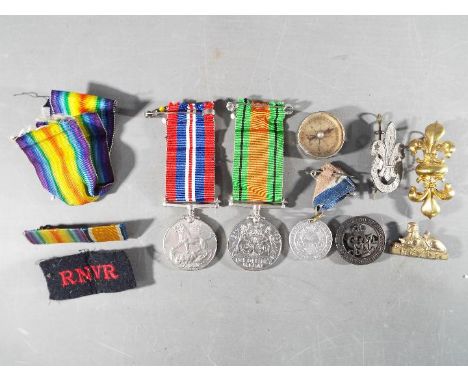

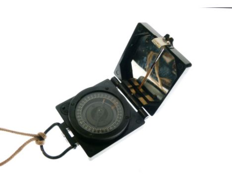

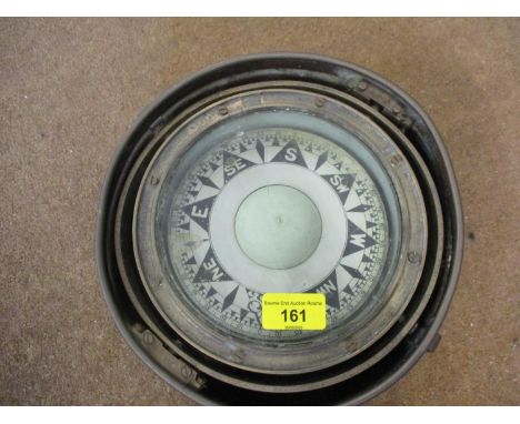
Los 174
Cleo Laine 14x10 mounted signed b/w photo. Dame Cleo Laine DBE born 28 October 1927 is an English jazz and pop singer and an actress, known for her scat singing and for her vocal range. Though her natural range is that of a contralto, she is able to produce a G above high C, giving her an overall compass of well over three octaves. Good Condition. UK Shipping from £4.99, Europe from £6.99 and ROW from £9.99.
Los 511
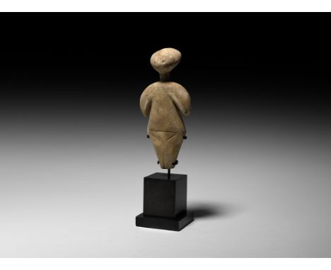
3rd millennium BC. A carved marble idol; arms bent at the elbow where a contrast in the size of the upper and lower arm is apparent; wide hips with tapering lower body; legs and pelvic region defined with incised lines at the front of the body; buttocks defined by a single downward facing triangular-shaped incised line at the rear; mounted on a custom-made stand. See von Bothmer, D., Glories of the Past: Ancient Art from the Shelby White and Leon Levy Collection, New York, 1990.526 grams total, 23cm including stand (9"). From an important London collection; formerly in an old private English collection, formed in the 1970s. Early Cycladic sculpture comprises predominantly female figures that range from simple modification of the stone to developed representations of the human form, some with natural proportions and some more idealised. Many of these figures, especially those of the Spedos type, display a remarkable consistency in form and proportion that suggests they were planned with a compass. Scientific analysis has shown that the surface of the marble was painted with mineral-based pigments-azurite for blue and iron ores, or cinnabar for red. The exact purpose of these figures is not known but their most likely function is as some sort of religious idol and the predominance of female figures, sometimes pregnant, suggests a fertility deity. Supporting this view is the fact that figurines have been found outside of a burial context at settlements on Melos, Kea and Thera. Alternatively, precisely because the majority of figures have been found in graves, perhaps they were guardians to, or representations of, the deceased. A video of this lot can be viewed on Timeline Auctions website. Fine condition.
Los 512
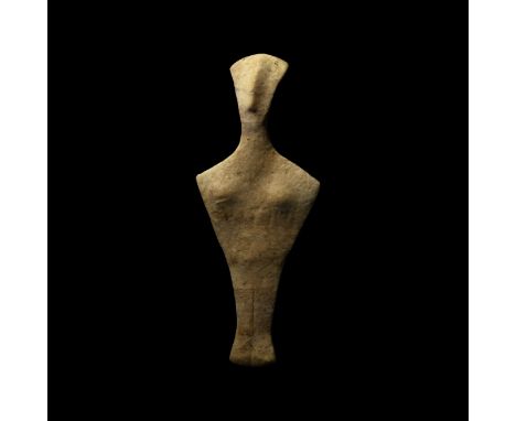
4th-3rd millennium BC. A fine grained marble figure of a stylised female; flat, fan-shaped head with long prominent nose ridge; flat lozenge-shaped body, small breasts; incised lines for the arms, legs together defined by incised line; mounted on a custom-made support. 430 grams, 27cm including support (10 1/4"). Property of a London gentleman; acquired from a major Mayfair gallery; acquired on the London art market before 2000. Early Cycladic sculpture comprises predominantly female figures that range from simple modification of the stone to developed representations of the human form, some with natural proportions and some more idealised. Many of these figures, especially those of the Spedos type, display a remarkable consistency in form and proportion that suggests they were planned with a compass. Scientific analysis has shown that the surface of the marble was painted with mineral-based pigments-azurite for blue and iron ores, or cinnabar for red. The exact purpose of these figures is not known but their most likely function is as some sort of religious idol and the predominance of female figures, sometimes pregnant, suggests a fertility deity. Supporting this view is the fact that figurines have been found outside of a burial context at settlements on Melos, Kea and Thera. Alternatively, precisely because the majority of figures have been found in graves, perhaps they were guardians to, or representations of, the deceased. Fine condition, old repair.
Los 19
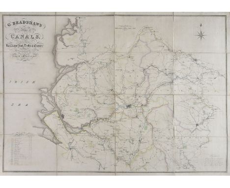
Canal Maps. Bradshaw (G.), G. Bradshaw's Map of Canals, Navigable Rivers, Rail Roads &c. of the Midland Counties of England from actual survey shewing the heights of the Ponds on the Lines of Navigation from a level of 6 feet 10 inches under the old dock sill at Liverpool.., G. Bradshaw, Manchester and sold by Jas. Gardner London, 1829, large engraved map with contemporary outline colouring, sectionalised and laid on linen, calligraphic title, compass rose and table of explanation, edged in green silk, 1345 x 1245 mm, together with G. Bradshaw's Map of Several Canals situated in the Counties of Lancaster, York, Derby & Chester; shewing the heights of their pools above the level of the sea at low water..., G. Bradshaw, Manchester and sold by Mr. Gardner, London, circa 1830, large engraved map with contemporary outline colouring, sectionalised and laid on linen, calligraphic title, compass rose and table of reference, slight offsetting and finger soiling, edged in green silk, 895 x 1260 mm, both maps contained in a contemporary green morocco book-box with 'envelope' style lid (near detached), box worn and frayed (Qty: 1)
Los 31
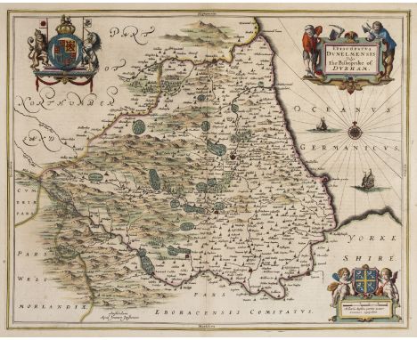
Durham. Jansson (Jan), Episcopatus Dunelmensis vulgo The Bishoprike of Durham, Amsterdam, circa 1650, engraved map with contemporary outline colouring, decorative cartouche, compass rose and numerous rhumb lines, slight fraying to margins but not affecting image, 410 x 510 mm, Latin text on verso, together with Blaeu (Johannes). Episcopatus Dunelmensis vulgo The Bishoprike of Durham, Amsterdam, circa 1648, engraved map with contemporary outline colouring, decorative cartouche and mileage scale, occasional printer's folds and slight creasing, central fold repaired, 385 x 505 mm, Dutch text on verso, with Slater (Isaac & Pigot James). Durham, circa 1855, engraved map with contemporary outline colouring, uncoloured vignette of Durham Cathedral, 235 x 365 mm (Qty: 3)
Los 39
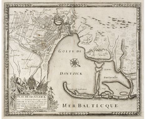
Gdansk/Danzig. De Fer (Nicolas & Danet G.), Plan de Dantzick avec ces Nouvaux Ouvrages Ville de Prusse..., Paris, circa 1734, uncoloured engraved city plan orientated to the South-west, large martial cartouche and compass rose, slight staining and spotting but largely confined to margins, 450 x 550 mm, together with Busch (Georg Paul). Danzig im Prospect der Weichselseite unter der Russisch-Sächsischen Belagerung 1734, Cologne, 1735, uncoloured engraved prospect after Daniel Schultz of the city under the Russian and Saksonian siege in 1734, showing the town on fire with a numbered key below the city prospect, old folds, 375 x 655 mm (Qty: 2)NOTESThe first described item is rare with only one other copy recorded in auction in the last twenty-five years. The second item is taken from G. D. Seyler and G. P. Schultz's 'Acurate Nachricht von der Russisch und Sachsischen Belager - und Bombariderung der Stadt Dantzig'. The plate was used agin by H. P. Merian in 1762 in 'Alte und neue Polnisch -Preussusche Chronika', but this is a fine dark impression from the first issue.
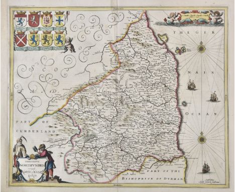
Los 68
Northumberland. Jansson (Jan), Comitatus Northumbria vernacule Northumberland, circa 1648, engraved map with contemporary outline colouring, decorative cartouche and mileage scale, compass rose and numerous rhumb lines, central fold partially strengthened on verso and with a short split, 410 x 500 mm, Latin text on verso, together with Blaeu (Johannes). Insula Sacra vulgo Holy Island et Farne, Amsterdam, circa 1645, engraved map with contemporary outline colouring, very slight staining to margins, 390 x 475 mm, French text on verso (Qty: 2)
Los 78
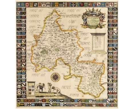
* Oxfordshire. Plot (Robert), The Map of Oxfordshire, circa 1677, hand coloured engraved map, decorative cartouche, mileage scale, table of explanation and compass rose, old folds, slight creasing, 500 x 480 mm, mounted, framed and glazed (Qty: 1)NOTESCreated by the first keeper of the Ashmolean Museum of Oxford and decorated with 172 coats of arms of the county's gentry, Oxford colleges, the city and the four county towns. One of the most decorative maps of Oxfordshire ever produced.
Los 102
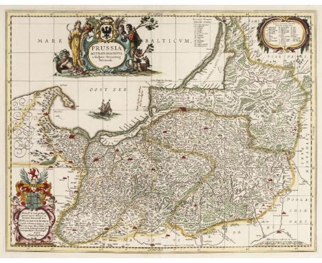
Prussia . Jansson (Jan & Schenk P. & Valk G.), Prussia accurata Descripta a Gasparo Henneberg Erlichensi, Amsterdam circa 1700, engraved map with contemporary outline colouring and some later enhancement, large decorative cartouche, central fold strengthened on verso, 380 x 490 mm, together with De Witt (Frederick). Regni Prussiae et Prussiae Polonicae Correctissima Descriptio..., Amsterdam, circa 1680, engraved map with contemporary hand colouring, large decorative cartouche, 465 x 590 mm, with Goos (P.). Carte van Pruyssen en Coerlandt, Amsterdam, circa 1660, hand coloured engraved sea chart of Gdansk Bay and part of the coast of Lithuania, large strapwork cartouche, compass rose and numerous rhumb lines, slight marginal fraying, 435 x 530 mm (Qty: 3)
Los 108
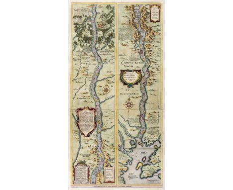
River Dnieper. Blaeu (Willem Janszoon), Campus Inter Bohum Borystenem, Amsterdam, circa 1645, hand coloured engraved map on two conjoined sheets, professionally re-margined at base, old folds, 655 x 325 mm, Dutch text on verso (Qty: 1)NOTESLarge map showing the course of the Dnieper River from Cherkasy to the estuary on the Black Sea. The map is in strip style with two vertical maps following the course of the river, each decorated with cartouches and compass roses and including numerous lengthy notations describing the cataracts, cities, salt mines, fortresses, and the historical traditions of the Kozaks. The map is based on an inset map from the important Radziwill-Makowski map of the Duchy of Lithuania (1613), which was the most accurate map of Lithuania and served as a resource for all other maps of the region for 150 years. Blaeu first published the map, along with the inset of the Dnieper River, as a four-sheet map in his Appendix in 1631. The map of Lithuania and the strip map of the Dnieper River then appeared separately in subsequent Blaeu atlases. The earlier editions have an additional title at the base flanked by putti which this example lacks.
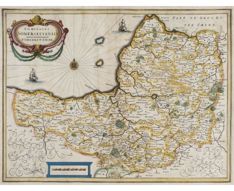
Los 116
Somerset. Jansson (Jan), Comitatus Somerettensis Somerset-Shire, circa 1638, engraved map with contemporary hand colouring, ornate strapwork cartouche and mileage scale, compass rose and numerous rhumb lines, slight staining, 385 x 510 mm, Dutch text on verso, together with Collinson (John). A Map of the County of Somerset, published C. Dilly, 1792, hand coloured engraved map originally published in Collinson's ' The History and Antiquities of the county of Somerset, collected from authentick records..., ', old folds, some weakness where old folds cross, one area of crude repair on verso, 480 x 630 mm, with Morden (Robert). Somersetshire, [1695], engraved map with contemporary outline colouring (it is rare to find Morden's maps with contemporary colouring), 360 x 425 mm, plus Slater J & Pigot (James). Somersetshire, circa 1857, engraved map with contemporary outline colouring, uncoloured vignette of Wells Cathedral, 240 x 360 mm (Qty: 4)NOTESThe first described item is in the scarce 'pre-atlas' state printed before the addition of the six coats of arms and a re-working of the title cartouche.
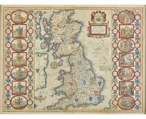
Los 12
* British Isles. Speed (John), Britain as it was devided in the tyme of the Englishe Saxons especially during their Heptarchy, Thomas Bassett & Richard Chiswell, [1676], hand coloured engraved map, published John Sudbury & George Humble, [1627], hand coloured engraved map, compass rose and numerous rhumb lines, fourteen engraved historical scenes to vertical margins, 385 x 510 mm, framed and glazed (Qty: 1)NOTESR.W.Shirley, Early Printed Maps of the British Isles, 1477 - 1650 , 317.
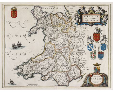
Los 125
Wales. Blaeu (Johannes), Wallia Principatus vulgo Wales, Amsterdam, circa 1660, hand coloured engraved map, large decorative cartouche, 390 x 495 mm, no text on verso, together with Jansson (Jan). Principatus Walliae pars Australis vulgo South-Wales, Amsterdam, circa 1650, engraved map with contemporary outline colouring, large decorative cartouche and mileage scale, compass rose and numerous rhumb lines, repaired closed tears affecting image, slight marginal fraying, 415 x 525 mm, French text on verso, with Bertius (Petrus). Cambria, [1616- 1639], uncoloured miniature engraved map, with additional title in French above map, and French text to verso, 100 x 140 mm (Qty: 3)
Los 13
British Isles. Speed (John), Britain as it was devided in the tyme of the English Saxons especially during their Heptarchy, John Sudbury & George Humble,1627, hand coloured engraved map,large strapwork cartouche, compass rose and numerous rhumb lines, the vertical borders decorated with historical scenes, areas of repair to central fold on verso, some mount and old tape staining to margins but not affecting image, occasional small marginal closed tears, 390 x 515 mm, English text on verso (Qty: 1)
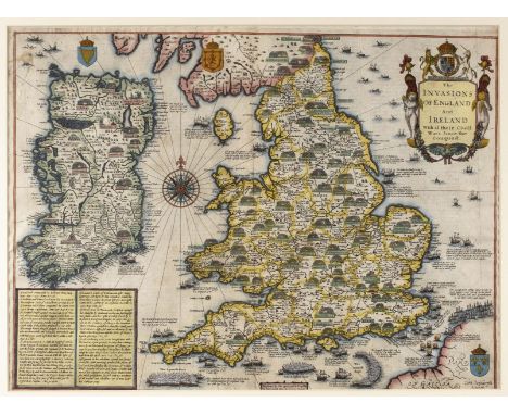
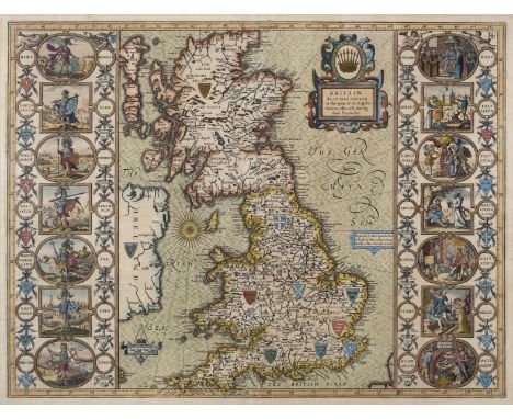
Los 14
* British Isles. Speed (John), The Invasions of England and Ireland with al their Civill Wars since the Conquest, George Humble, circa 1627, hand coloured engraved map, large compass rose and numerous rhumb lines, slight staining, 375 x 505 mm, English text on verso, mounted, framed and glazed (Qty: 1)
Los 354
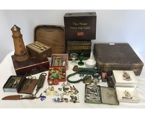
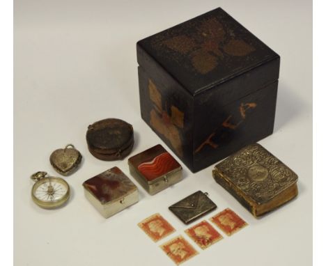
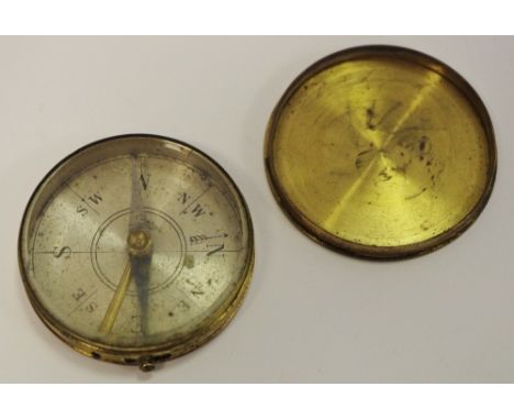
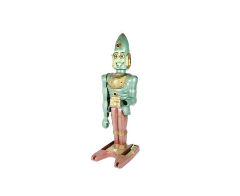
A Marx Toys Big Loo Giant Moon Robot, c.1963, large plastic robot, approx 950mm in height, with sight scope, flashing battery powered red eyes, hand cranked voice box, grasping claw, spring loaded missile launcher, base mounted rocket launcher, compass, morse code clicker, two original ivory rockets, five original Space Spheres (four blue, one red), good quality homemade additional gripping claw, replacement crank handle and a quantity of reproduction 3D printed accessories (whistle, moon grenade etc), F-G, crank handle repaired, Morse code label replaced
-
36562 Los(e)/Seite