36562 Preisdatenbank Los(e) gefunden, die Ihrer Suche entsprechen
36562 Lose gefunden, die zu Ihrer Suche passen. Abonnieren Sie die Preisdatenbank, um sofortigen Zugriff auf alle Dienstleistungen der Preisdatenbank zu haben.
Preisdatenbank abonnieren- Liste
- Galerie
-
36562 Los(e)/Seite


Los 179
Bowles (John, publisher). Ogilby's Travellers Guide: or Gentleman's Pocket Companion through all the Direct and principal Cross Roads in England and Wales..., Printed for John Bowles in Cornhill & Carington Bowles next the Chapter House..., circa 1732 - 52, hand coloured engraved map with a decorative cartouche and a separate strapwork cartouche with an explanation, old folds and slight overall toning, 330 x 285 mmQty: (1)NOTESA diagrammatic road map, with a title that matches R. W. Shirley, Printed Maps of the British Isles 1650 -1750, Bowles 5, but the publication line is different. It is also similar to Shirley's Anon.6 but with a different cartouche and lacking the explanatory text below the map, and again it has similarities with Moll 2 but the title does not match. A similar map is illustrated in Francis Bennet's 'The Roads of Devon and Cornwall' but it has a compass rose in the Bristol Channel, lacking on this version. It is possible that the map was published for an edition of Moll's atlas but this is supposition. Undoubtedly rare if somewhat elusive.
Los 186
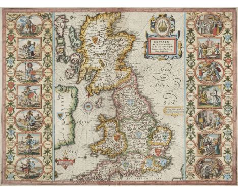
British Isles. Speed (John), Britain as it was devided in the tyme of the Englishe Saxons especially during their Heptarchy, John Sudbury and George Humble, circa 1627, hand coloured engraved map, strapwork cartouche, compass rose and numerous rhumb line, the vertical borders decorated with 14 historical scenes, central fold repaired on verso, with slight worming at base of fold, margins repaired on verso,385 x 510 mm, English text on versoQty: (1)NOTESR. W. Shirley. Early Printed Maps of the British Isles, 317.
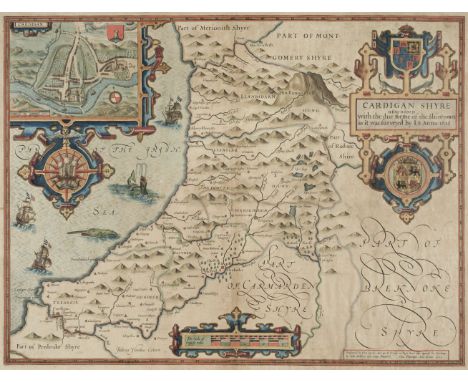
Los 191
* Cardiganshire. Speed (John), Cardigan Shyre described with the due forme of the shire town as it was surveyed by J. S. Anno 1610, John Sudbury & George Humble, [1627], hand coloured engraved map, inset town plan of Cardigan, large strapwork cartouche, compass rose and mileage scale, good margins, slight dust soiling, 385 x 505 mm, framed and double-glazed, English text on versoQty: (1)
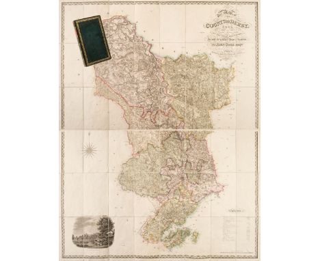
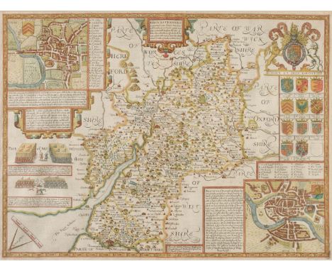
Los 194
Derbyshire. Sanderson (George). This map of the County of Derby from a Careful Survey made in the years 1834 and 1835, is with the greatest respect inscribed to John Coke Esqre. Of Debdale, One of His Majesty's Justices of Peace for the County, 1st edition, published Septr. 15, 1836, engraved large scale map with bright contemporary hand colouring, sectionalised and laid on linen on two sheets, calligraphic cartouche, compass rose, table of explanation and an uncoloured engraved view of Haddon Hall, contemporary green card endpapers, each sheet 780 x 1210 mm, contained in a contemporary morocco gilt book box with contrasting morocco label to spineQty: (1)NOTESProvenance: The Estate of the late David Wilson (1926-2020). An uncommon large scale map in very good condition. Similar in style to the Greenwood map which had been published eleven years earlier but with greater detail. Sanderson is probably best known for his monumental circular wall map of '20 Miles round Mansfield'
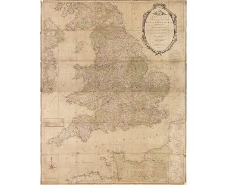
Los 199
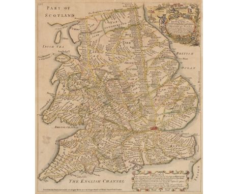
England & Wales. Carington Bowles (publisher), Bowles's New and Accurate Map of England and Wales Comprehending all the Cities, Boroughs, Market and Sea-Port Towns, Villages, Lakes, Rivers, Forests, Ruins and Principal Seats of the Nobility; with the roads described by Daniel Paterson..., 1782, large engraved map on two sheets, sectionalised and laid on later linen. large decorative cartouche and compass rose, inset map of the Scilly Isles, some fraying to margins with slight loss, toned overall, some fraying with slight loss where old folds cross, some dust soiling and staining, overall size 1290 x 1010 mmQty: (1)
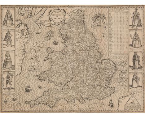
Los 205
England & Wales. Speed (John), The Kingdome of England, 1st edition, John Sudbury & George Humble, 1611, uncoloured engraved 'carte-a-figure' map with eight costumed figures to vertical margins, old folds, some cracking and slight loss along folds, some thinning to printed surface strengthened on verso, some marginal fraying and short closed tears, slight spotting, 385 x 515 mm, English text on verso, together with another later hand coloured copy, some creasing , several repaired closed tears, partial loss to border along upper margin, 385 x 515 mm, no text on verso, with Britain as it was devided in the tyme of the Englishe Saxons especially during their Heptarchy, John Sudbury & George Humble, [1627], engraved map with early hand colouring, elaborate strapwork cartouche, compass rose and numerous rhumb lines, the vertical borders decorated with fourteen historical scenes, toned and stained overall, margins frayed and with several closed tears causing slight loss, central fold repaired on verso, 380 x 505 mm, English text on verso, plus Blaeu (Johannes). Magnae Britanniae et Hiberniae Tabula, Amsterdam, circa 1648, hand coloured engraved map, inset map of the Orkney Islands, toned overall with some staining, central fold strengthened on verso, repaired closed tear affecting image, two small holes along central fold, slight creasing, 390 x 500 mm, German text on verso, and Anglia Regnum, Amsterdam, circa 1645, engraved map with contemporary outline colouring, additional horizontal fold, slight creasing and spotting, old adhesion scars to verso, 385 x 500 mm, Dutch text on versoQty: (5)
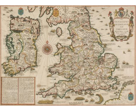
Los 206
* England, Wales & Ireland. Speed (John), The Invasions of England and Ireland, with al their Civill Wars since the Conquest, Thomas Bassett & Richard Chiswell, [1676], hand coloured map, engraved by Cornelius Danckertz, table of explanation decorative cartouche, compass rose and numerous rhumb lines, slight spotting, 380 x 515 mm, mounted, framed and double-glazed, glass cracked on verso, English text to versoQty: (1)
Los 216
* Gloucestershire. Speed (John), Glocestershire contrived into thirty thre severall hundreds & those againe into foure principall devisions. The Citie of Glocester & Bristowe discribed with the armes of such noble men as have bene dignified with ye titlles of Earles & Dukes thereof, Thomas Bassett & Richard Chiswell, [1676], hand coloured engraved map, inset town plans of Gloucester and Bristol, short repair at base of central fold, 380 x 510 mm, mounted, framed and double glazed, English text on verso, together with Saxton (Christopher & Hole G.). Glocestriae comitatus olim sedes Dobunorum, [1637], hand coloured engraved map, large strapwork cartouche, mileage scale and compass rose, 285 x 320 mm, mounted, framed and glazed, with Owen (John & Bowen Emanuel). Glocestershire, [1720 or later], hand coloured engraved map with descriptive text below image, 185 x 120 mm, mounted, framed and glazedQty: (3)NOTESA surprisingly dark impression - for the 1676 edition - well coloured and with good margins.
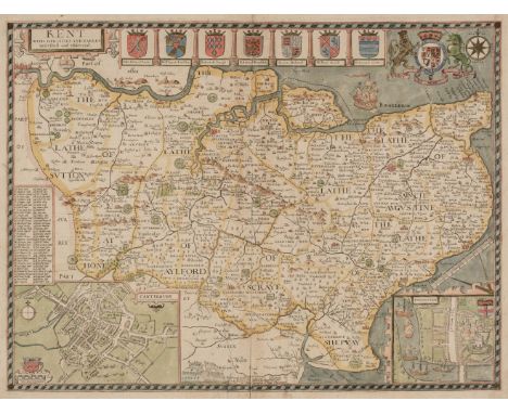
Los 221
Kent. Speed (John), Kent with her Cities and Earles described and observed, Thomas Bassett & Richard Chiswell, 1676, hand coloured engraved map, inset town plans of Rochester and Canterbury, central fold strengthened on verso, repaired marginal closed tears, 380 x 510 mm, English text on verso, together with Jansson (Jan). Cantium vernacule Kent, Amsterdam, circa 1648, engraved map with contemporary outline colouring, decorative cartouche, compass rose and numerous rhumb lines, torn with very slight loss to the upper right corner, central fold strengthened and repaired on verso, some oxidisation to old watercolour causing some cracking and splitting, several repaired closed tears, 380 x 500 mm, Latin text on verso, with another copy with several long repaired closed tears, fraying with some loss and crude later hand colouring, Latin text on verso, plus Blaeu (Johannes). Cantium vernacule Kent, Amsterdam, circa 1665, engraved map with contemporary outline colouring, cartouche and heraldic shields remain uncoloured, ink manuscript 'J. Blaeu 1645' added to the cartouche, old watercolour oxidised resulting in some cracking and small holes affecting image, toned overall, 385 x 525 mm, no text on verso and Saxton (Christopher & Kip William). Cantium quod nunc Kent, [1637], hand coloured engraved map, strengthening to lower corners, some old card adhesion to upper corners, heavily toned overall, 280 x 380 mmQty: (5)
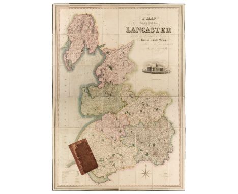
Los 224
Lancashire. Hennet (G.), A Map of the County Palatine of Lancaster Divided into Hundreds and Parishes from an accurate Survey made in the years 1828 and 1829, Henry Teesdale & Co, May 1st. 1830, large scale map engraved by James Bingley, with bright contemporary hand colouring, sectionalised and laid on linen, large calligraphic cartouche, engraved vignette of the New Custom House Liverpool, compass rose and table of explanation, slight offsetting, edged in green silk, marbled endpapers, 1620 x 1130 mm, contained in a contemporary calf book box, the box is worn and frayedQty: (1)
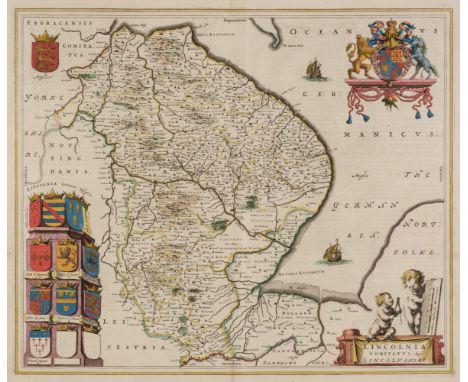
Los 227
Lincolnshire. Jansson (Jan), Lincolnia Comitatus Anglis Lyncolne Shire, Amsterdam, circa 1648, engraved map with contemporary outline colouring, decorative cartouche and mileage scale, compass rose and numerous rhumb lines, short split at head of central fold, very slight spotting and text show through, 400 x 500 mm, French text on verso, together with Blaeu (Johannes). Lincolnia Comitatus Anglis Lincoln-shire, Amsterdam, circa 1645, engraved map with contemporary outline colouring, decorative cartouche and mileage scale, 425 x 505 mm, Dutch text on versoQty: (2)
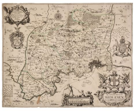
Los 240
Middlesex. Ogilby (John), An Actuall Survey of Midlesex, George Willdey, circa 1732, engraved map by Walter Binnerman with sparse outline colouring, large title cartouche and dedication, compass rose and two armorial coats of arms, trimmed to neatline, slight staining, old folds with some strengthening on verso, small abraided hole in mileage scale, slight marginal fraying, slight adhesion scaring to verso, 415 x 525 mm, together with Norden (John, after). Middlesex olima Trinoban Tibus habitata, [1637], uncoloured engraved map, large strapwork cartouche and table of explanation, some staining to central fold, 270 x 335 mmQty: (2)
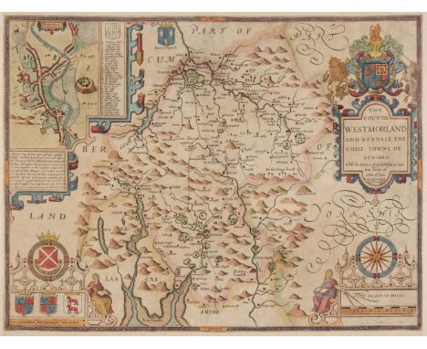
Los 246
Northern Counties. Speed (John), The Countie of Westmorland and Kendale the cheif towne described, Henry Overton, circa 1743, hand coloured engraved map, an inset town plan of Kendal, large strapwork cartouche, mileage scale and compass rose, trimmed to neatline with margins extended, 380 x 505 mm, no text on verso, together with The Bishoprick and Citie of Durham, 1st edition, [1611], uncoloured engraved map, an inset town plan of Durham, torn with very slight loss to strapwork margin at the lower right corner, long repaired closed tear affecting image, slight thinning to paper but with no loss, 380 x 505 mm, English text on verso, with The North and East Ridins of Yorkshire, published John Sudbury & George Humble, circa 1627, hand coloured engraved map, inset town plans of Richmond and Hull, some marginal fraying with slight loss to strapwork margin, slight staining, slight abrasion to the printed surface, small margins, 390 x 515 mm, English text on versoQty: (3)
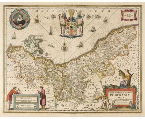
Los 273
Poland/Pomerania. Jansson (Jan), Nova Illustrissimi ducta Pomeraniae tabula, Amsterdam, circa 1630, engraved map with contemporary outline colouring, large decorative cartouche and mileage scale, compass rose and numerous rhumb lies, occasional marginal repaired closed tears but not affecting image, 385 x 495 mm, French text on verso, together with Dankerts (Theodore). Ductas Pomeraniae Tabula Generalis in qua sunt Ducatus Pomeraniae, Stettinensi, Cassubiae, Vandaliae et Bardensis..., Amsterdam, circa 1690, engraved map with contemporary outline colouring, large decorative cartouche, some marginal finger and dust soiling, 500 x 580 mm, with De Wit (Frederick). Marchionatus Brandenburgi et Ducatus Pomeraniae tabula..., Amsterdam, circa 1680, engraved map with contemporary outline colouring, very slight staining, 490 x 565 mm, plus Rossi (Giacomo Giovanni), La Pomerania divisa in Citerioe ò Reale..., Rome 1689, hand coloured engraved map, large decorative cartouche, 435 x 555 mmQty: (4)
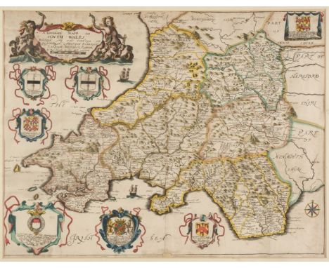
Los 297
* Wales. Blome (Richard), A Generall Mapp of South Wales wherein are the Countyes of Glamorgan, Carmardan, Pembrok, Cardigan, Brecknock, Radnor, [1673], hand coloured engraved map, decorated with six heraldic coats of arms, decorative cartouche, old folds, slight staining, 345 x 455 mm, mounted, framed and glazed, together with Saxton (Christopher & Hole G.). Glamorgan comitatus qui olim pars Silurum, [1637], hand coloured engraved map, large strapwork cartouche, mileage scale and compass rose, 275 x 340 mm, mounted, framed and glazed, with Rocque (John). Radnor Shire, [1753], hand coloured engraved map, inset map of the Northumberland coast and Holy Island, 200 x 160 mm, mounted, framed and glazedQty: (3)
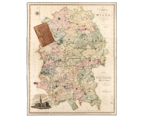
Los 301
Wiltshire. Greenwood (C.), Map of the County of Wilts, from actual survey in the years 1819 & 1820, published Dec.12th, 1820, engraved map with bright contemporary hand colouring, sectionalised and laid on linen, calligraphic title, dedication, compass rose, table of explanation and an uncoloured vignette of Salisbury Cathedral, edged in green silk, 1440 x 1115 mm, marbled endpapers, contained in a contemporary calf book box with contrasting morocco label to spine, worn and rubbedQty: (1)NOTESA bright and clean copy.
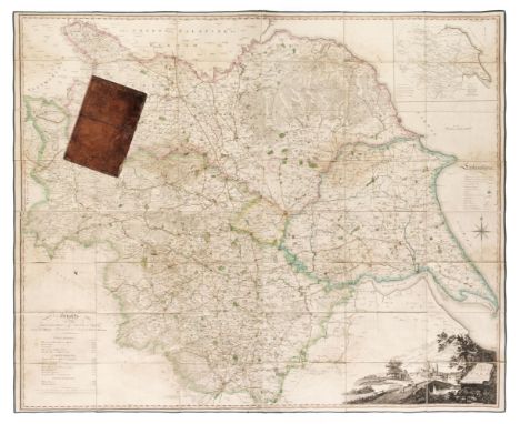
Los 303
Yorkshire. Tuke (John), Map of the County of York republished with additions & corrections, 4th edition, 1816, large scale engraved map with contemporary outline colouring, sectionalised and laid on linen, large uncoloured cartouche which includes a distant view of York Minster, inset map of Yorkshire, table of explanation, compass rose and table of heights of the principal hills, some staining, edged in green silk, 1200 x 1420 mm, marbled endpapers, contained in a contemporary calf book box some wear and crude sellotape repairs to boxQty: (1)NOTESProvenance: The Estate of the late David Wilson (1926-2020).
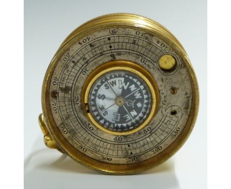
Los 966
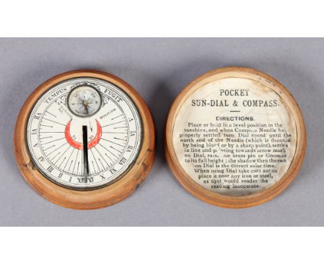
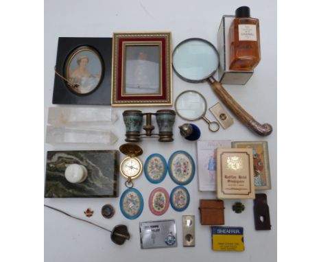
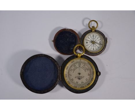
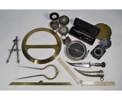
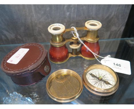
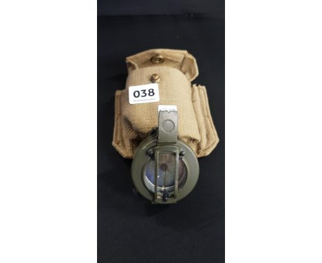
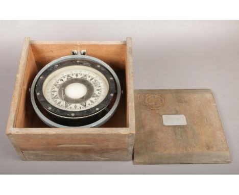
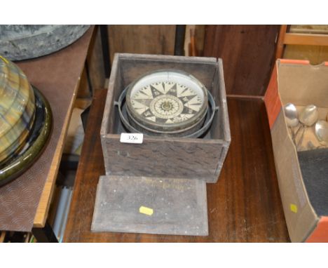
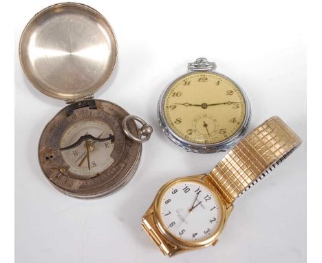
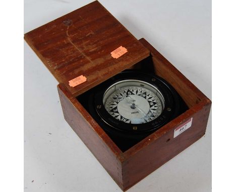
A 19th century gilt brass pocket barometer with silvered dial, J H Steward Ltd, Strand, London, in morocoo case, to/w a similar smaller pocket compass (2) - Steward good overall but horizontal surface scratch from centre to left, dial dirty, case showing some tarnishing, needle moves under pressere, case good/intact - Crichton compass good, case good
Los 305
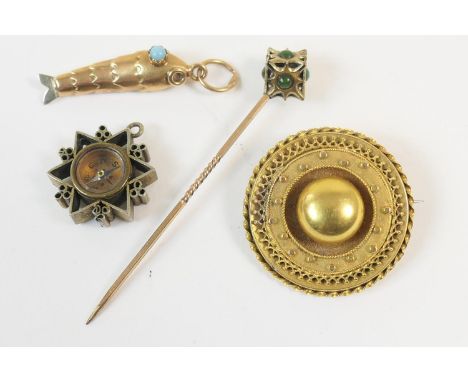
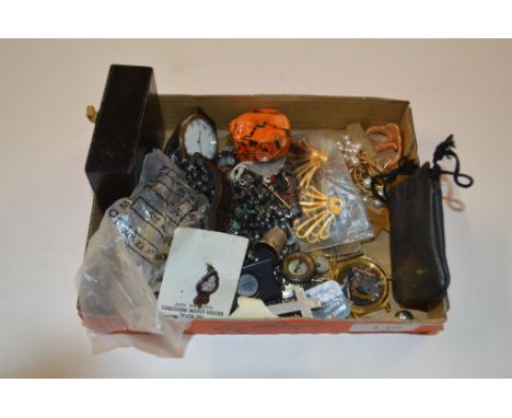
Victorian gold target brooch, unmarked, 28mm diameter, gross weight approx. 4.9g; also a yellow metal fish charm with turquoise eyes, unmarked, 30mm, gross weight approx. 2.8g; a turquoise and gold plated stick pin; and a silver gilt compass fob, 17mm (4) (Viewing is by appointment only during published times. Bidding is by commission, telephone or online only. Condition report available on request).
Los 321
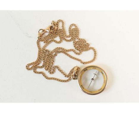
9ct gold compass pendant, suspended from a 9ct gold fine curb link necklace, the compass 15mm diameter, the necklace 44cm, gross weight approx. 7.5g (Viewing is by appointment only during published times. Bidding is by commission, telephone or online only. Condition report available on request).
Los 513
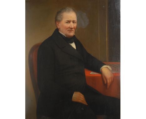
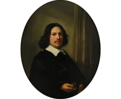
Attributed to Aelbert Cuyp (Dutch 1620-1691)Portrait of a gentleman holding a compass Oil on panel, oval 94.5 x 75.5cm; 37Ό x 29Ύin Provenance: Sir Gregory Osborne Page-Turner, 4th Bart; His sale, Phillips, London 19-20 April 1815, lot 177, where bought by Alexander Baring, 1st Baron Ashburton, as Aelbert Cuyp, self-portrait (£75: 12s); Lord Ashburton, The Grange, 1890; His collection purchased as a whole by Agnews and others, August, 1907; Lionel de Rothschild (1882-1942); Edmund de Rothschild (1916-2009); The Trustees of Exbury House Literature: J. Smith, A Catalogue Raisonnι of the Works of the Most Eminent Dutch, Flemish and French Painters, vol. V (London, 1834), no. 268, as Aelbert Cuyp; G. F. Waagen, Works of Art and Artists in England, vol. II, (London, 1838), p. 283, as Cuyp; E.W.Moes, Iconographia Batava (Amsterdam, 1897), p.215, no. 1871 - 3 & 5, as Cuyp; F. Cundall, The Landscape and Pastoral Painters of Holland (London, 1891), p. 163, as Cuyp; E. Michel. 'Une famille d'artistes hollandaise: Les Cuyps', in Gazette des Beaux-Arts, p.114, as Cuyp; C. Hofstede de Groot, A Catalogue Raisonnι of the Works of the Most Eminent Dutch painters..., vol. II (London 1909), pp. 29-30, no. 70, as Cuyp; A. Chong, Aelbert Cuyp and the Meanings of Landscape, PhD. Dissertation, (New York University, 1992), no. C141 (under rejected works, on the basis of a black and white photograph) Exhibited: London, Royal Academy, Winter Exhibition, 1890, no. 91, as Aelbert Cuyp; London, Royal Academy, Dutch Pictures, 1450-1750, Winter Exhibition, 1952-1953, no. 480, as Cuyp; London, Thos. Agnew and Sons, European pictures from an English County, 1957, as CuypWe are grateful to Dr. Alan Chong for the attribution of this work on the basis of photographs.

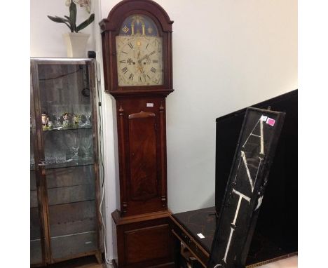
Los 219
An unusual 19th century Masonic mahogany cased longcase clock, the polychrome and gilt painted arched dial profusely decorated with Masonic symbols including Square and Compass, Solomon's Temple, the Blazing Star etc, enclosing a chapter ring with Roman numerals and two subsidiary dials, within a conforming hood with arched pediment over a glass door (glass cracked), the trunk with a shaped door between a pair of relief carved spindles, raised on bracket feet, eight day movement, with weights and pendulum. Height 217cm
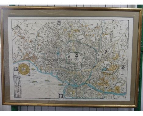
Los 341
Japan: A 19thC Japanese woodblock printed Map of Tokyo, orientated to the West, showing the old centre of Edo with the Imperial palace and the mouth of the river Sumida, with areas and details picked out in yellow and orange and with a compass rose device with inscription in the lower left corner, fold lines, sheet size 22¾in x 33¼in (58cm x 84.5cm) framed and glazed.
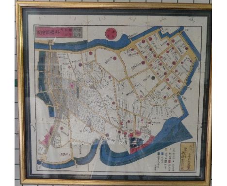
Los 342
Japan: Two 19thC late Edo period Japanese woodblock printed pocket Maps: 'Nihonbashi and Kanda, 1851' and 'Yatsuya, Akaska Gate Negata Cho, 1851', each map clearly displays streets, waterways, city blocks and individual buildings with areas and details picked out in colours, a corresponding key in the lower left corner, a compass rose device and two inscriptions, fold lines and worm tracks, sheet size 19½in x 21½in (49.5cm x 54.5cm) framed and glazed (2)
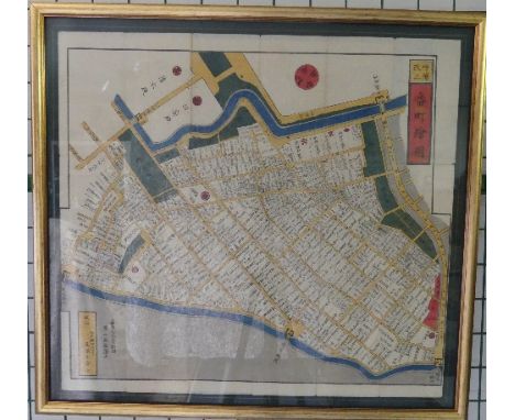
Los 343
Japan: Two 19thC late Edo period Japanese woodblock printed pocket Maps: 'Tokyo - Aoyama area, 1853' and 'Tokyo - Bancho and Kojimachi areas, 1853', each map clearly displays streets, waterways, city blocks and individual buildings with areas and details picked out in colours, a corresponding key in the lower left corner, a compass rose device and two inscriptions, fold lines and worm tracks, sheet size 19¾in x 21¾in (50cm x 54.5cm) framed and glazed (2)
Los 47
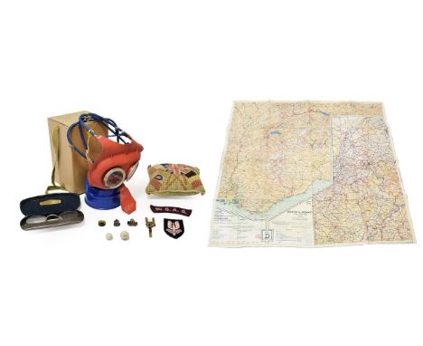
A Small Quantity of Militaria, comprising a Second World War Mickey Mouse respirator for a small child, in original cardboard box; a pair of gas mask spectacles with steel frames in original steel case; an embroidered cloth 1st SAS shoulder title, cap insignia and brass badge; silk escape map of Holland, Belgium, France, Germany and Switzerland; an escape and evasion compass; Home Guard and ARP lapel badges; a woolwork pin cushion worked with the allied flags; two lead bullets
-
36562 Los(e)/Seite