36562 Preisdatenbank Los(e) gefunden, die Ihrer Suche entsprechen

Verfeinern Sie Ihre Suche

Jahr

Sortieren nach Preisklasse
  • Liste
  • Galerie
  • 36562 Los(e)
    /Seite

Los 215

A pair of French 18th or 19th century silver, garnet and white paste shoe buckles, each rectangular, and set around the edge with oval cut wine-purple garnets, one at each corner, pairs at the compass points, separated by twining lines of round cut white stones, all in closed back settings; French boar's head mark for silver; length 5.2cm; in later but period fitted green morocco case

Los 358

Lusina - an 18ct gold cased slimline pocket watch, the silvered checker board dial signed 'Chronometre Lusina', having Arabic numerals in gold, subsidiary seconds, the keyless 18 jewel movement signed Lusina, unnumbered, case 45mm diameter, dial 40mm, the case with black enamel line decoration, back with Swiss marks and numbered 27257, suspended from a fine 18ct two colour gold watch chain, 37cm, mounted with a 15ct gold compass fob, gross weight of watch 51gm, chain 11.9gm, fob 7.2gm. Contained in a later green leather fitted case

Los 752

S. Yeates, Dublin, a George III brass cased pocket sextant, the circular lift off lid enabling the gnomon to rise and the sun dial to be read, the compass glazed in below, 9cm (3.5 in.) diameter Other Notes: Samuel Yeates is recorded working in Dublin from 1790-1831

Los 399

A 19th century brass travelling pocket compass

Los 204

A 20th century nautical themed map reading set:, the oak box with plated banding and brass anchor decoration enclosing a fitted interior with small two draw telescope, compass, sand glass and ebony handled magnifying glass, the box 8cm x 22cm x 9.5cm

Los 57

A rare Georgian compass by George Wilson, London c1825:, the 5 inch painted dial within a brazed brass case inscribed to bezel 'George Wilson Sherwood St, London', mounted in a later wooden base, diameter 28cm.

Los 65A

A WWI period prismatic compass by J H Steward, London:, in leather case:.

Los 69A

A Japanese 4 inch spit bar compass with sprung mounting:, together with a Sestral hand held compass, a framed set of Wills 'Ship's Badges' cigarette cards and a framed print of the paddle steamer 'Duchess of Devonshire' aground at Sidmouth. (4)

Los 78

A WWII period Mark III compass together with a dashboard clock by Smiths, a map reading lamp and a collection of map reading instruments:, together with four books relating to navigation (a lot)

Los 80

A Type O6A hand held compass:, in original issue box.

Los 82

An Edwardian teak and brass yacht binnacle compass by Christie & Wilson, Glasgow:, the 4 inch liquid filled dial signed as per title in a gimbaled mount under a squat oval cover with observation window and two lamp apertures, in a brass bound octagonal case on a bronze mounting bracket, 36cm high.

Los 87

A polished steel parallel rule in mahogany case:, of traditional form with moustache hinges, calibrated top rule and compass calibrated lower rule.

Los 614

Sale Item: J HALDEN & CO COMPASS SET (AF) Vat Status: No Vat Buyers Premium: This lot is subject to a Buyers Premium of 15% + Vat @ 20% Additional Info : Lots purchased online with the-saleroom.com will attract an additional charge for this service in the sum of 3% of the hammer price plus VAT @ 20%

Los 474

LATE 19TH CENTURY ELLIOTT BROS LONDON BRASS POCKET COMPASS, with engraved name to case 'Charles H.C. Halkess'

Los 184

A Sestrel maritime compass, with brass and iron gimblel mount, in later fitted case.

Los 575

Bedouin brass Qibla compass, 19th Century, traditional circular form with hinged engraved cover opening to a small compass behind glass and engraved gradations with zodiacal symbols, 11cm diameterNote: These compasses were used by the Muslim Faithful to locate Qibla (the direction of the Kaaba in Mecca) for Sholat (prayers)

Los 576

Bedouin brass Qibla compass, 19th Century, traditional circular form, the hinged cover inscribed with concentric lines of script, opening to reveal a small compass behind glass against a table of gradations inscribed with the signs of the zodiac, 10.5cm diameterNote: These compasses were used by the Muslim Faithful to locate Qibla (the direction of the Kaaba in Mecca) for Sholat (prayers)

Los 100

Hobson (William Colling). This Map of Yorkshire is most respectfully dedicated to the Nobility, Clergy, Gentry, Landowners and Manufacturers of the County, pub. William Colling Hobson, York, 1st ed., July 1843, fine engraved map with original outline colouring, sectionalised and laid on linen, on two sheets, calligraphic title, compass rose and table of explanation, each sheet approximately 1255 x 760 mm, original cloth with gilt decorated upper board and spine, steel clasp, bumped to extremities (1)

Los 141

British Isles. Speed (John), Britain as it was devided in the tyme of the Englishe Saxona especially during their Heptarchy, published John Sudbury & George Humble, [1627], hand coloured engraved map, compass rose and numerous rhumb lines, fourteen engraved historical scenes to vertical margins, central fold partially strengthened on verso, faint printers folds, 385 x 510 mm, English text on verso R.W.Shirley. Early Printed Maps of the British Isles, 1477 - 1650, no.317. (1)

Los 167

England & Wales. Bellin (Jacques Nicolas), Carte R‚duite des Isles Britanniques en cinq feuilles..., Premiere Feuille [together with] Carte R‚duite des Isles Britanniques..., Seconde Feuille, 1757, two hand coloured engraved sea charts, large ornate cartouche to each sheet, compass rose and numerous rhumb lines, slight fraying at base of central fold on sheet one, each approximately 560 x 870 mm Originally published in the 'Neptune Francois'. (2)

Los 169

England, Wales & Ireland. Speed (John), The Invasions of England and Ireland with al their Civill Wars since the Conquest, published George Humble, circa 1627, hand coloured engraved map by Cornelius Danckerts, decorative cartouche, compass rose and numerous rhumb lines, one repaired marginal closed tear, 385 x 520 mm, English text on verso Shirley. Early Printed Maps of the British Isles, 1477 - 1650, no.397. (1)

Los 172

Estate Plan. Whistpaine (Robert), The survey of farme lying in the parish of Tollesbury, in the countye of Essex and of late belonging to Henry Smith Esq. who did by his last will give to the poore of the parish of Southover, twelve pounds yearly for ever ishewing out of this farme; this farme was survayed by Ralph Dowcet in 1659 and inscribed by Robert Whistpaine in 1664, large pen and watercolour estate plan on vellum, with a decorative strapwork cartouche, compass rose and mileage scale surmounted by dividers, slight staining, some adhesion scarring to verso, 700 x 820 mm (1)

Los 173

Estate Plan. Harris (John, surveyor), To the Right Honorable Edward Earl of Oxford and Mortimer and to James King Esq. This Map of the division of North-wood in the Township of Noke in the Parish Of Pembridge, County of Hereford. According to the directions of William Preece, Richard Turberville and Roger Edwards Gentlemen Commissioners..., 1781, pen and wash plan on vellum edged in silk, large ornate strapwork cartouche and mileage scale, the scale decorated with the tools of a surveyor, table of reference and compass rose, slight dust soiling, 545 x 575 mm, manuscript title of the enclosure repeated on verso in a contemporary hand (1)

Los 174

Estate Plan. A Map & Description of the Manor of Walmer lyinge in East Kente with one Tenement one Parte of Marsh and 16 Peeces of Errable & Pasture thereunto belonginge, contayninge acers 320:0:2, [surveyed by] William Boycot, 16[40?], pen, ink and watercolour on vellum, decorative strapwork cartouche, coat of arms, compass rose and distance scale, a flotilla of ten ships in the sea outside Deal Castle, one ship (heavily soiled and indistinct) outside Walmer Castle, plus a few smaller vessels in the sea, also depicting the two castles and buildings for the towns of Deal and Walmer, the coastal bulwark ('White Bullworke' and 'Blacke Bullwork'), also identifying various plots, the boundary for the Archbishop of Canterbury, the road from Deal to Dover, names of tenants and their landholdings including Edward Boys, Robert Gillo, Caleb Cocke, William Coppin, Sir Matthew Mennes and Ezekiel Parker [died 1641?], a few small holes, some soiling throughout including very heavy soiling from mildew largely occuring in two vertical strips (just east of Deal Castle and through Walmer and Walmer Castle), blue wash border with old stud holes from previous framing, rebacked on modern thick paper, 538 x 715 mm A rare Kentish estate plan from the reign of King Charles I, which in spite of its condition issues is historically revealing. William Boycot (flourished 1615-48) 'was a prolific cartographer of considerable skill with a distinctive use of blue and yellow, especially in his borders and for other decoration and also of a fine red pigment... he worked widely but mainly in the east of the county... More than twenty of his maps are known to survive and as a group they form one of the finest Kentish expressions of cartography for the years before the Interregnum' (F. Hull, 'Kentish Map-Makers of the Seventeenth Century' in Archaeologia Cantiana, volume 109 (1991), p. 70).N.B. It has been noted that the above item may contain manorial documents which are subject to the Manorial Documents Rules 1959, 1963 and 1967, administered by The Historical Manuscripts Commission at The National Archives on behalf of the Master of the Rolls. Accordingly the purchasers of the documents lie under an obligation to notify the Secretary of the Commission of their acquisition and to provide details of where they will be kept. They may in no circumstances be removed from England and Wales without the prior consent of the Master of the Rolls. (1)

Los 187

*Grenada. Bellin (Jacques Nicolas), Carte de L'Isle de la Grenade, published Paris, 1760, hand coloured engraved sea chart, inset horizon profile, compass rose and numerous rhumb lines, stamp of 'La Depot de la Marine', 890 x 580 mm, mounted, framed and glazed (1)

Los 194

Ireland. Speed (John), The Province of Connaugh with the citie of Galwaye described, published John Sudbury and George Humble, circa 1627, uncoloured engraved map, inset town plan of Galway, vertical margins trimmed with loss to strapwork borders, central fold split and crudely repaired on verso, some abrasion to image, some marginal closed tears, slight staining, 390 x 505 mm, English text on verso, with The Countie of Leinster with the citie Dublin described, 1st edition, published John Sudbury and George Humble, circa 1611, uncoloured engraved map, inset town plan of Dublin, trimmed to strapwork margins, central fold split with old sellotape stains, repaired marginal closed tears, slight worming, 390 x 510 mm, English text on verso, with The Isle of Man exactly described..., 1st edition, circa 1611, uncoloured engraved map, large strapwork cartouche and compass rose, abrasion to printed surface causing some loss to image, 380 x 505 mm, English text on verso, plus half of John Speed's map of the Isle of Wight (3)

Los 200

*Java. Van Keulen (Gerard), Insulae Iavae Pars Occidentalis Edente Hadriano Relando / Insulae Iavae Pars Orientalis Edente Hadriano Relando, published Amsterdam, circa 1753, engraved map on two conjoined sheets with contemporary outline colouring, inset map of the harbour of Batavia and a large panorama view of Batavia from the sea, decorative cartouche and ten compass roses and numerous rhumb lines, old folds, some spotting, 515 x 1180 mm, framed and glazed The second state of this large and scarce map of Java; published in volume VI of Van Keulen's 'De Nieuwe Groote Ligtende Zee-Fakkel, 't Vyfde Deel'. (1)

Los 215

*Monmouthshire. Saxton (Christopher & Hole William), Monumethensis comitatus quem olim incoluerunt silures, circa 1610, hand coloured engraved map, decorative strapwork cartouche, mileage scale and compass rose, 275 x 340 mm, mounted, framed and glazed, together with Bowen (Emanuel), Herefordshire divided into hundreds..., [1767], engraved map with contemporary outline colouring, originally published in the 'Atlas Anglicanus', 230 x 325 mm, mounted, framed and glazed, with Kitchin (Thomas), An Accurate Map of the County of Radnor..., published R. Baldwin in 'The London Magazine', [1747 - 1760], hand coloured engraved map, old folds, toned overall, 170 x 220 mm, mounted, framed and glazed, plus Kitchin (Thomas), Middlesex drawn from an accurate survey, circa 1760, uncoloured engraved map, sectionalised and laid on linen, 185 x 195 mm (4)

Los 216

*Montgomeryshire. Speed (John), Montgomery Shire, published John Sudbury & George Humble, [1627], hand coloured engraved map, inset town plan of Montgomery, strapwork cartouche, compass rose and mileage scale, central fold partially strengthened on verso, 380 x 505 mm, mounted, framed and double glazed (1)

Los 246

Suffolk & Norfolk. Blaeu (Johannes), De zeecusten van Engelandt tuschen Aelborgh en Crammer, published Amsterdam, circa 1623, hand coloured sea chart orientated to the south east, compass roses and numerous rhumb lines, 260 x 355 mm Originally published in 'Het licht der Zeevaert'. (1)

Los 253

*Venezuela. Van Keulen (Johannes), Pas kaart vande zee kusten van Vene‡uela met de Byleggende Eylanden door vooght geometra, published Amsterdam, circa 1680, engraved sea chart with contemporary outline colouring, orientated to the south, inset maps of Curacao and Tortuga, large decorative cartouche, compass rose and numerous rhumb lines, 515 x 580 mm, mounted, framed and glazed (1)

Los 258

Wales Mercator (Gerard & Jansson Jan), Cambriae Typus auctore Humfredo Lhuydo Denbigiense Cambro Britanno, [1647 or later], engraved map with contemporary hand colouring, decorative cartouche and mileage scale, compass rose and numerous rhumb lines, 350 x 490 mm, no text on verso John Booth. Antique Maps of Wales no.5. (1)

Los 82

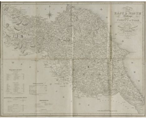
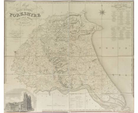
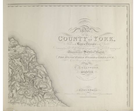
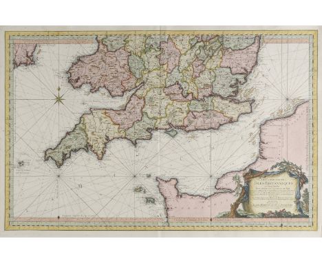
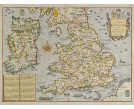
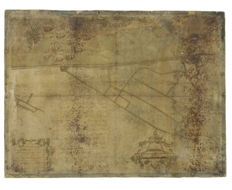
Baines (Edward, publisher), Map of the East & North Ridings of the County of York, Including the latest Improvements, Engraved for the History and Directory of Yorkshire, published Leeds, 1822, engraved folding map laid on linen, calligraphic title and table of explanation, bound with Neele (Samuel John), Kingston upon Hull with its Environs, 1823, engraved folding map laid on linen, calligraphic title, table of reference, topographical vignette and three heraldic shields, 255 x 300 mm, bound with Neele (Samuel John), York, 1822, engraved folding map laid on linen, engraved topographical vignette and table of reference, 310 x 260 mm, bound with Baines (Edward, pubs.), Map of the West Riding and Ainsty of the County of York, Engraved for the Directory, 1822, engraved folding map, laid on linen, calligraphic title and compass rose, 415 x 530 mm, bound with folding town plans of Leeds & Sheffield, and two triangular mileage table for Yorkshire and for England and Wales, book plate of P. Hornby Apothecary & Druggist, York, contemporary marbled endpapers, hinges strengthened, contemporary diced calf, rebacked but retaining original spine, lacking small sections at head and foot of spine, 8vo A collection of eight folding maps relating to Yorkshire. (1)

Los 87

Bryant (A.), Map of the East Riding of Yorkshire from actual survey..., in the years 1827 & 1828, published A. Bryant 1829, large scale uncoloured engraved map, sectionalised and laid on linen, calligraphic title, compass rose, table of ecclesiastical divisions and table of explanation, engraved vignette of Beverley Minster, edged with pink silk, linen folds strengthened on verso 1300 x 1510 mm, contained in a contemporary marbled card slipcase with manuscript paper label to upper board, worn at extremities (1)

Los 96

Greenwood (C.), Map of the County of York, made on the Basis of Triangles in the County, determined by Lieut. Col. Wm. Mudge, Royal Art. F.R.S. and Captn. Thos. Colby, Royal Eng. in the Trigonometrical Survey of England by order of the Honourable Board of Ordnance and Surveyed in the Years 1815, 1816 & 1817, published Robinson Son & Holdsworth, Leeds [and] John Hurst & C.Greenwood, Wakefield, June 4th 1817, uncoloured large scale engraved map on nine sheets, calligraphic title, compass rose, list of the altitudes of the principal mountains and a table of explanation, occasional marginal closed tears, slight dust soiling, each sheet approximately 610 x 710 mm (1)

Los 2723

A pietra dura globe on brass stand with compass, height 35cm

Los 257

A yellow metal intaglio seal with Masonic emblem with compass verso together with a pair of 9ct gold masonic earrings

Los 325

A Victorian bracelet made up of faceted links with charms including a compass and a Victorian earring

Los 2724

A pietra dura globe on brass stand with compass below, height 45cm

Los 114

British military compass, 'Magnetic Marching Mark I' with War Department arrowhead and registration number B320696. Maker's initials: T.G. Co. Ltd.(B.P. 24% incl. VAT)

Los 210

Military compass, the hinged top with mother of pearl chapter ring, arrow mark to the base

Los 2215

A George III spade guinea 1794 and bloodstone set pendant locket seal, opening to reveal a compass, the bloodstone monogram seal engraved. Illustrated

Los 284

A pair of painted distressed metal wall mounted compass design sculpture H:105cm W:105cm

Los 164

A Kelvin & Hughes London Natural Sines Brunton compass, dated 1917

Los 253

A hallmarked 9ct yellow gold pin brooch by Louis Augustus Leins, a French-style fob seal, a cased compass on short chain and t-bar, and a pin brooch all testing for 9ct yellow gold. Gross weight 20g (4)

Los 202

American Lionel Company copper deck binnacle with Ritchie compass card, 33cm high.

Los 203

Vintage miniature gimballed brass ship's compass, 13cm diameter, and a larger brass ship's compass, 19cm diameter. (2)

Los 1048

Royal Engineers; a collection of memorabilia including a carved mahogany Royal Engineers plaque, 11in (28cm) high, Royal Engineers car badge, uniform buttons and badges, Aldershot Royal Engineers' Lodge leather pouch, military whistles, compass, pin-badges, etc (a lot)

Los 197

A collection of American Scouts equipment including three hats, badges, compass, wrist compass, two belts with whistle, cap and three neckerchiefs with toggles.

Los 389

Vintage jewellery including a Moonstone riveria necklace, an early Felix the cat enamelled brooch, an albert chain with compass fob and hat pins etc

Los 1290

A collection of items to include old pocket watches, compass, pen nibs, cut throat razors etc

Los 1372

Tiffany silver cased barometer and compass explorer set, London 1912. Thermometer and bow missing. 6.8cm dia.

Los 963

A 9ct yellow gold watch chain - Length 38cm - with compass - broken - approx total weight 38 grams

Los 706

A World War II Aviation compass type P4A No 43342T - possibly from a Lancaster Bomber

Los 208A

A Victorian three drawer pocket telescope by Dolland of London, a WWI field compass, Verner's pattern, in leather case, and a Kodak folding camera, leather cased

Loading...Loading...
  • 36562 Los(e)
    /Seite

Kürzlich aufgerufene Lose