36562 Preisdatenbank Los(e) gefunden, die Ihrer Suche entsprechen
36562 Lose gefunden, die zu Ihrer Suche passen. Abonnieren Sie die Preisdatenbank, um sofortigen Zugriff auf alle Dienstleistungen der Preisdatenbank zu haben.
Preisdatenbank abonnieren- Liste
- Galerie
-
36562 Los(e)/Seite

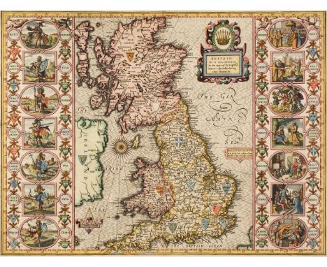
Los 245
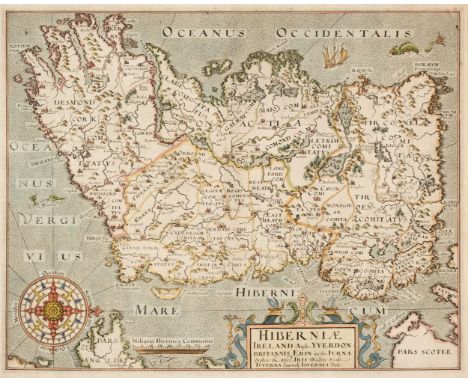
* British Isles. Speed (John), Britain as it was devided in the tyme of the English Saxons especially during their Heptarchy, John Sudbury & George Humble,1627, hand coloured engraved map, large strapwork cartouche, compass rose and numerous rhumb lines, the vertical borders decorated with historical scenes, short split at top of central fold, 390 x 515 mm, English text on verso, mounted, framed and double glazedQTY: (1)NOTE:Shirley, Early Printed Maps of the British Isles, 317.
Los 270
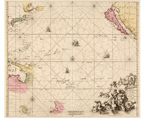
Pacific Ocean. Renard (Louis), Magnum Mare del Zur cum Insula California. De Groote Zuyd-Zee en 't Eylandt California, Amsterdam, [1715], engraved chart with contemporary hand colouring, ornate uncoloured allegorical cartouche with a portrait of Magellan (the first man to cross the Pacific Ocean), compass rose and numerous rhumb lines, insular California and early projections of Australia and New Zealand, 495 x 570 mmQTY: (1)NOTE:Burden, Mapping of North America II, 469. The third state of this map, originally published by Frederick De Wit in 1675. Philip D.
Los 275
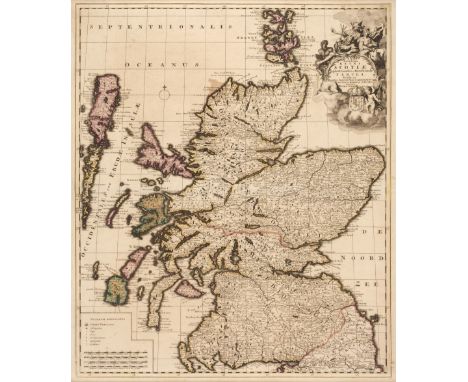
* Scotland. Schenk (Pieter), Novissima Regni Scotiae Septentrionalis et Meridionalis Tabula..., 1708, engraved reticulated map with contemporary outline colouring, uncoloured cartouche, table of explanation and mileage scale, slight staining, laid on later card, 585 x 495 mm, framed and glazed, together with Hole (Guillaume). Scotia Regnum, circa 1610, hand-coloured engraved map, large strapwork cartouche and compass rose, large margins, 265 x 315 mm, framed and glazedQTY: (2)
Los 282
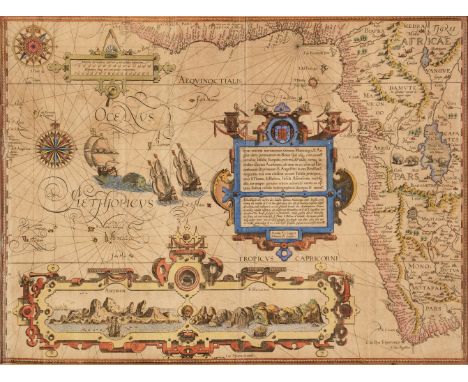
* West Africa. Van Linschoten (Jan Huygen), Typus Orarum Maritimarum Guineae, Manicongo, & Angolae ultra Promontorium Bonae Spei susq..., Amsterdam, circa 1596, hand-coloured map engraved by Arnold Florent van Langren, inset horizon profiles of Ascension Island and St Helena, compass rose and numerous rhumb lines, large and ornate strapwork cartouche, light overall toning, old folds, occasional marginal closed tears, 390 x 525 mm, mounted, framed and glazedQTY: (1)NOTE:Originally published in Linschoten's 'Itinerario'. One of the most spectacular and decorative late 16th-century maps of Africa. Although Linschoten was Dutch, he was employed by the Portuguese Archbishop of Goa and his 'Itinerario...' contained many maps derived from Portuguese sources. The prominent inset views of the islands of Ascension and St. Helena were both important Portuguese possessions. The very small portrait of a bearded man wearing a hat which is set into the strapwork margins of the two islands is probably a portrait of the engraver, Arnold van Langren.
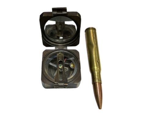
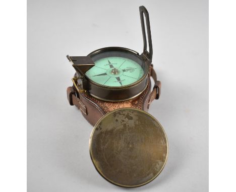
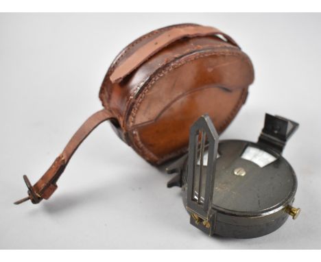
Los 732
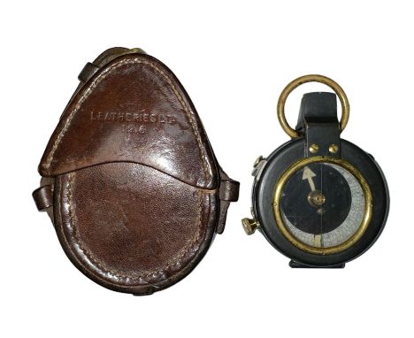
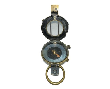
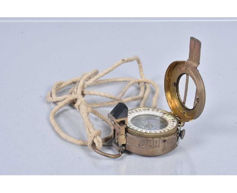
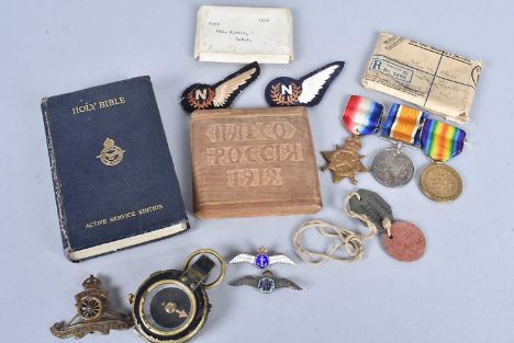
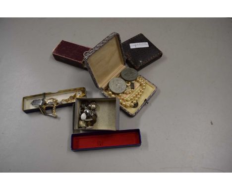
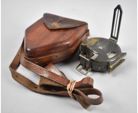
A WWI Royal Field Artillery (RFA) trio, awarded to Corporal Norman Hill (1040), also with the Service Number 780108, comprising Victory, War and 1914-15 Star, also sold in the lot, dog tags, a 1918 Engineer Corps Field Pocket compass, a Royal Artillery Cap badge, two silver RAF sweetheart brooches, two Navigators cloth wings, a POW cigarette case, plus an RAF Holy Bible (parcel)
Los 464
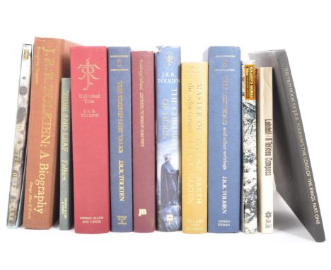
J. R. R. Tolkien (John Ronald Reuel Tolkien (1892 - 1973) - Collection of hardback books to include; The shores of middle earth, the book of lost tales, unfinished tales, tree and leaf, A biography, the lost road and other writings, master of middle earth, the children of Hurin, Lobdell / A Tolkien compass, Tolkien's World, The Hunting of the Snark Lewis Carroll.
Los 1142
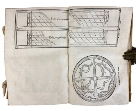
SCHÖNER, A. Gnomonice. Hoc est: De descriptionibus horologiorum sciotericorum omnis generis, proiectionibus circulorum sphaericorum ad superficies, cum planas, tum convexas concavasqu[ue], sphaericas, cylindricas, ac conicas: item delineationibus quadrantum, annulorum, &c. (...). Nuremberg, J. Montanus & U. Neuberus, 1562. (6), cviii lvs. W. 3 double-p. woodcut plates, numerous diagrams, printer’s device on v° of last leaf. Fol. Cont. limp vellum w. overl. sides. (Ties partly gone, vellum a bit stained/w. some small tears, no endpapers, title-page lacks but a facsimile title-p. on old paper is bound in (well-executed!), hole in leaf a2 repaired w. minor loss of text, some marg. stains). NOTE: First edition of this well-illustrated work concerning horology, the construction of sundials on flat and curved surfaces, the manufacture of astrolabes, how to determine longitude without using a mariner's compass, etc. - Adams S-677; Honeyman 2800; Houzeau & Lancaster 11370; VD16 S-3458.
Los 494
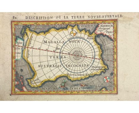
ANTARCTICA -- "DESCRIPTION de la Terre Soubs-Australe" (sic!). Amst., J. Hondius, (1618). Engr. map, cold. by hand, with title in French on v°. 97 x 135 mm. (paper size 117 x 180 mm.). (Hinges from previous mount present on v°). NOTE: Engraved map of the South Polar unknown lands, with sailing ship, sea monster and two compass roses. This was one of the first maps to focus on the South Pole. From Bertius' "La Geographie Racourcie". - V.d. Krogt IIIA, 342:11 (plate 10, p. 451) (0030:342).
Los 522
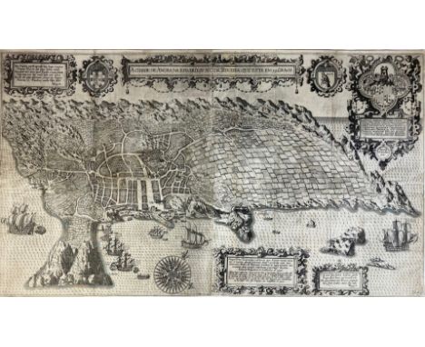
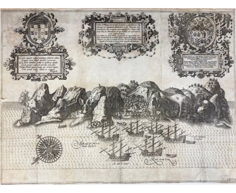
AZORES -- LINSCHOTEN, HUYGEN VAN -- "A CIDADE DE ANGRA. Na ilha de Iesu xpoda Tercera. Que esta em 39. graos". (Amsterdam, 1596). Plain engr. birds-eye view of the island of Terceira and the town of Angra by Johannes Baptista v. Doetecum. 485 x 832 mm (image size). (Many repairs to v°, margins short/trimmed to plate edge, small disruptions to surface of image in places which are restored/supplemented by a later hand, sold w.a.f., not subject to return). NOTE: Beautiful view of Terceira with many ships in the foreground, 5 intricate cartouches, a compass rose, and 2 coats of arms. From the lower cartouche: "Affbeeldinge vande Stat Angra, met het Slot op het Eijlant Tervera, welcke alle de Eijlanden onderworpen zijn, diemen Azores ofte de Vlaemsche Eijlanden noemt, (…)". Engraved for Huygen van Linschoten's 'Itinerario'. Strong impression, but unfortunately w. some defects. - Schilder, Mon. cart. VII, p. 195, fig. 10.4; Tiele, Mémoire, p. 89.
Los 577
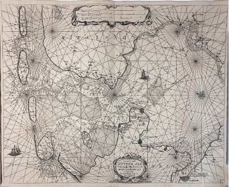
LOW COUNTRIES -- "PASCAARTE vande Zuyder-Zee, Texel, ende Vlie-stroom, als mede 't Amelanders-gat". Amst., J. Theunisz. [Lootsman], n.d. (between 1662 and 1666?). Plain engr. nautical chart w. title cartouche and compass rose. (A bit browned, but a decent copy). NOTE: This variant editon (with map number '3' in lower right corner which was erased in 1666 with the 3rd state) with the name of Jacob Theunisz. is not mentioned in Spiegel v.d. Zuiderzee Z16.
Los 578
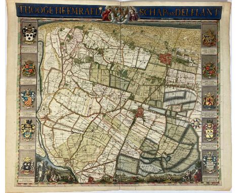
LOW COUNTRIES -- "THOOGE HEEMRAEDSCHAP van Delflant". N.pl., 1712-50. Engr. plain general map of polder district 'Delfland' by Van Anse, Doesburgh, (a.o.) after N. & J. Kruikius w. engr. title in top border and w. 5 fine engr. coats of arms by P. Haringh on each outer side, all in very handsome cont. colouring and richly heightened w. gold. 520 x 580 mm. (Central fold 'rep.' on v° w. adhesive tape, small tear running into image visible in lower right margin). NOTE: Fine map embellished with several allegorical figures and small views, representing lots of details on a scale 1:45,000. With fine compass-rose (with a globe in the centre!). Strong impression of the 2nd, augmented, edition from 1750 which was published by I. Tirion. - Donkersloot-de Vrij 806 note.
Los 588
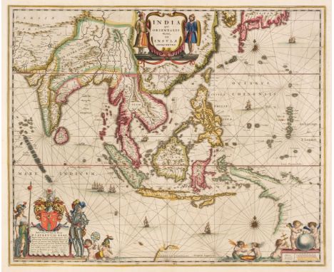
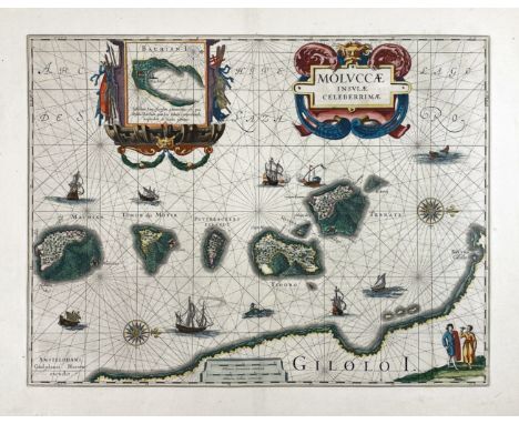
MALAY ARCHIPELAGO -- "MOLUCCÆ Insulæ Celeberrimæ". Amst., W. Blaeu, (c. 1645). Engr. chart in cont. colouring w. 2 intricate cartouches, scale indicator, 2 compass roses, ships, sea monsters, etc. 377 x 494 mm. NOTE: Attractive map in fine condition. Cf. V.d. Krogt 8560:2.2. Text in Dutch on v°.
Los 607
SAINT HELENA -- LINSCHOTEN, HUYGEN VAN -- "INSULA D. HELENÆ (…)". (Amsterdam, 1596). Plain engr. birds-eye view of the island of Saint Helena by Johannes Baptista v. Doetecum. 375 x 510 mm (image size). (Hinged to mount, small tear in left outer margin, folds visible, image surface a bit rubbed in places, some repairs to v°, margins short/trimmed to plate edge). NOTE: Two views of Saint Helena occur in Huygen van Linschoten's 'Itinerario' of which this is the largest; they are the first published views of the island. The harbour of St. Helena in particular was a preferred provisioning place and meeting point for ships returning from the East. Ships in the foreground, a compass rose and 3 intricate cartouches, of which 2 contain coats of arms. - Tiele, Mémoire, p. 88; Schilder, Mon. cart. VII, p. 216-7 & p. 195, fig. 10.4.

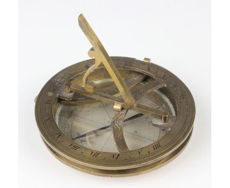
Los 1275
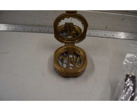
A 19th century brass equinoctial pocket sundial, the brass circular base with glazed silvered compass rose and blued steel pointer, mounted with a hinged latitude arc, the hinged chapter ring with Roman numerals and folding gnomon, diameter 8.5cm.Buyer’s Premium 29.4% (including VAT @ 20%) of the hammer price. Lots purchased online via the-saleroom.com will attract an additional premium of 6% (including VAT @ 20%) of the hammer price.
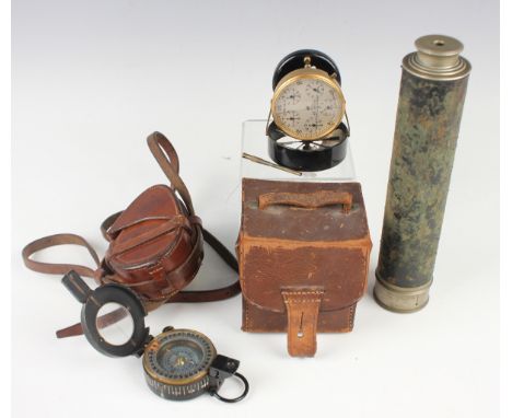
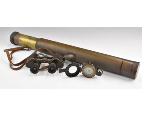
Los 1279
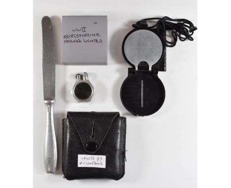
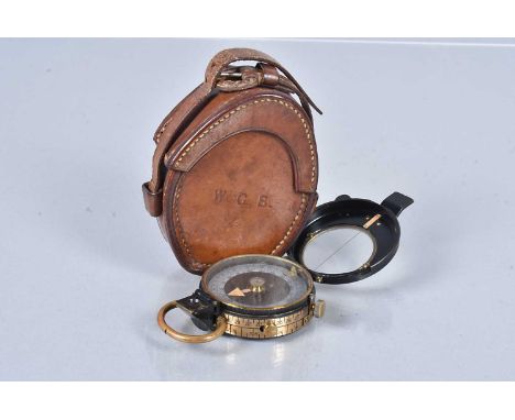
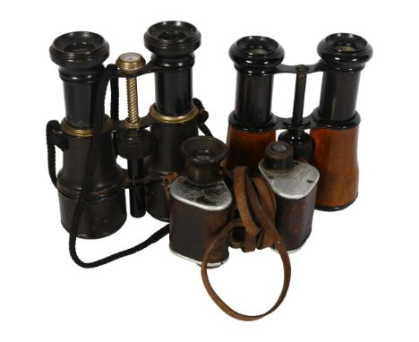
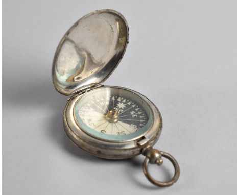
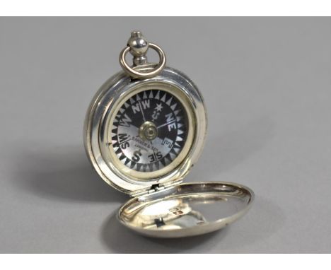
A mid-20th century gilt lacquered brass and black enamelled anemometer, the circular silvered dial detailed 'Air Meter Patent No. 3729, No. 12702', the underside detailed 'W.H Harling 47 Finsbury Pavement London', with leather case, together with a black enamelled brass pocket compass, the underside detailed 'T.G. Co. Ltd London 1939 MK III', with leather travelling case, and a leather mounted and nickel plated three-draw telescope, unextended length 23.5cm.Buyer’s Premium 29.4% (including VAT @ 20%) of the hammer price. Lots purchased online via the-saleroom.com will attract an additional premium of 6% (including VAT @ 20%) of the hammer price.
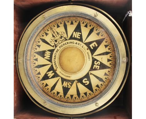
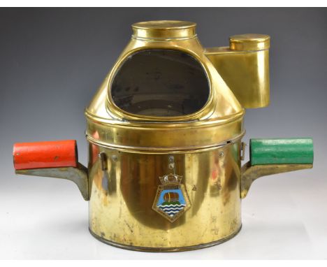
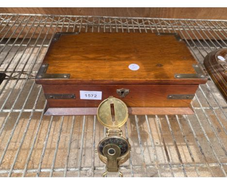
Los 1278
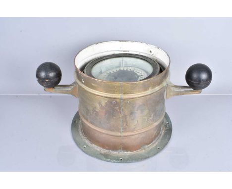
An early 20th century brass gimbal mounted marine/ship's compass, the 10-inch black and white printed circular dial detailed 'Constantine, Pickering & Co Ltd, London, Middlesbro', within a brass bound wooden box, width 36.5cm.Buyer’s Premium 29.4% (including VAT @ 20%) of the hammer price. Lots purchased online via the-saleroom.com will attract an additional premium of 6% (including VAT @ 20%) of the hammer price.
-
36562 Los(e)/Seite