36562 Preisdatenbank Los(e) gefunden, die Ihrer Suche entsprechen
36562 Lose gefunden, die zu Ihrer Suche passen. Abonnieren Sie die Preisdatenbank, um sofortigen Zugriff auf alle Dienstleistungen der Preisdatenbank zu haben.
Preisdatenbank abonnieren- Liste
- Galerie
-
36562 Los(e)/Seite


Los 950
AN ENGLISH BRASS THREE INCH REFRACTING TELESCOPE with two eyepieces, on brass stand with compass joint, black painted iron folding legs , stained deal fitted case with label of CLARKSONS 338 HIGH HOLBORN, LONDON WC ++Tube dented, lenses undamaged, lacquer original but worn and discoloured in places


Los 45
Track and Ground Speed Calculator probably from a US Naval Airship c1943. An aluminium device to measure groundspeed, comprising a base ring of Aluminium, with the points for the compass marked in degrees on both inner and outer faces, a second component rotates below the inner ring with Track and Drift markings. A third complex component contains markings for Wind speed and direction, Air course and speed, and Datum Ship course and speed. An intriguing device, but without instructions. GC for age, possibly parts missing.


Los 766
"Photographic Books: Determination of the Sensitivity of Photographic Plates by Hurter & Driffield;, Patent Abridgements - `Group XX Photography, Scientific Instruments` 1937 & 1938, Year-Book of Photography & Photographic News Almanac 1887 and `The Photographic Journal` 1916, including `Journal of the Royal Photographic Society`, hard covers, 261pp Determinationof the Sensitivity of Photographic Plates by Hurter & Driffield; typed, annotated & bound in hard covers, from 1890 article in the Journal of the Soc. Of Chemical Industry, Patent Abridgements - ‘Group XX Photography, Scientific Instruments’ 1937 & 1938 Nos.440,001 – 480,001 including Noel Pemberton-Billing No. 478,342 for a feature on his Compass camera and Year-Book of Photography & Photographic News Almanac 1887, re-bound in hard covers, Woodbury type facing title page, 250pp of which 140 advertisements and ‘The Photographic Journal’ 1916 includes ‘Journal of the Royal Photographic Society’ with a listing of members 160 x234mm, hard covers, 261pp"


Los 14
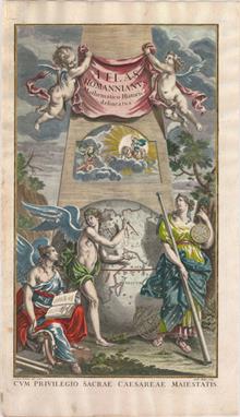
Homann Heirs, 1762 Atlas Homannianus Mathematico-Historice Delineatus An evocative title page with a large globe and three female figures. The two angelic figures represent History and Geography, while the third classical muse is Urania, goddess of Astronomy or Navigation, standing by with a telescope, a compass, and an armillary sphere. The top of the map is balanced with a pair of putti holding the banner title, while below Apollo in his sun-chariot greets a personification of the North Star as night passes into day. Drawn by Johann Justin Preister and engraved by Andreas Hoffer. 10.8" W x 18.6" H Watermarked paper with marginal soiling.

Los 17
Mercator, Rumold 1587 Orbis Terrae Compendiosa Descriptio An elaborate strapwork border surrounds this beautiful double-hemisphere map, and an armillary sphere and 32-point compass rose are tucked between the hemispheres. Rumold Mercator based this map on his father`s great world map of 1569. The North Pole is depicted as a landmass surrounding a sea from which four rivers radiate and there is a well depicted "Northwest Passage". The huge "Terra Australis" is shown as a part of Tierra del Fuego, and the lands of "Lucach, Maletur" and "Beach" (from the travel account of Marco Polo) are noted along the coast in the vicinity of present day Australia with a large island labeled "Iava Minor" located in the same region. Japan is shown in a kite-shaped configuration, with the fictitious "Satyrorum insule "(Satyr`s Island) shown above. South America has a bulge on its southwest coast, and New Guinea is depicted in a large, circular configuration. The map embodies many ancient authorities and is a wonderful view of classical cartography. Cracks in the copper plate are visible in the title, indicating a later publication circa 1619. French text on verso. 20.6" W x 11.4" H Attractive color with expert paper repairs along centerfold, else fine.

Los 20
Plancius, Petrus 1625 Orbis Terrarum Typus de Integro Multis in Locis Emendatus... This handsome world map, first issued in 1590, was based on Rumold Mercator`s map of 1587. It incorporates the improvements made by Ortelius with a re-shaped South America and inclusion of the Solomon Islands. Plancius introduced new information, based on Portuguese reports, on the far-west coast of America and the western coastline of Africa. Japan is shown for the first time as one small and three larger islands, although still misshapen. It is beautifully engraved in a strapwork surround with a compass rose and armillary sphere tucked between the hemispheres. This example is the third state from a Dutch Bible with the attribution D.R.M. Mathes. Engraved by Baptista Doeticum, Dutch text on verso. 20.3" W x 11.3" H Issued folding, now pressed. Dutch Bible maps are often found with damaged side margins, but the margins on this example are in excellent condition. There are a few small, unobtrusive spots in the image and light stains in top blank margin, far from image.

Los 21
Blaeu, Willem 1635 Nova Totius Terrarum Orbis Geographica ac Hydrographica Tabula "A magnificent map featuring a carte-a-figures border with allegorical representations of the sun, the moon, the five known planets, the four elements and the four seasons. Along the bottom are vignettes showing the seven wonders of the world: the Hanging Gardens of Babylon, the Colossus straddling the harbor at Rhodes, the Pyramids, the Mausoleum of Halicarnassus at Cairo, the Temple of Diana, the Statue of Jupiter and the lighthouse at Alexandria. Josua van Ende engraved this map, reducing it from Blaeu`s 1605 wall map for inclusion in atlases. Petrus Plancius` world map of 1592 was the main source of geographical information. The map is shown on Mercator`s projection with a massive Southern Continent attached to New Guinea, with the coastal names of “Beach” and “Psittacorum regio” noted from Marco Polo`s travel memoirs. North America has the westward bulge characteristic of the time, with the “Strait of Anian” noted. Korea is shown as an island and Japan is in a kite-like shape. The map itself is richly decorated with cartouches, sea battles, monsters and compass roses. Fourth state with “Tierra del Fuego” shown as an island and the date omitted from the lower cartouche on the right. French text on verso, published between 1635-50." 21.5" W x 16.1" H Watermarked paper with old color that has been refreshed, a minor printer`s crease adjacent to centerfold at bottom, and marginal soiling.

Los 36
Bellin, Jacques Nicolas 1748 Essay d`une Carte Reduite Contenant les Parties Connuees du Globe Terrestre... Early issue of this fine large world chart on Mercator`s projection decorated with a large title cartouche and two compass roses. North America is shown with a very pronounced "River of the West" connecting through a series of rivers and lakes from Lake Superior to the Pacific - representing the elusive "Northwest Passage". The Russian discoveries in the North Pacific are not yet shown, although there is a note about the voyages of 1743. Australia is labeled "Nouvelle Hollande" with "Terre de Diemen" and "Nouv. Guinee" both linked to the mainland. New Zealand is only partially formed and there are numerous islands in the Pacific. 27.5" W x 19.8" H Issued folding on watermarked paper with some faint toning, two tears near the lower compass rose that have been professionally repaired on verso, and a few tiny splits at fold intersections.

Los 106
Bellin, Jacques Nicolas 1764 Plan de la Ville de Quebec This attractive and historical map of Quebec presents the city as it would have appeared when the French surrendered at the end of the "French and Indian War". It is based on earlier plans by Bellin, first published in 1744, that continued to be the definitive view for many years. The list at right names and keys 24 buildings, batteries, and forts; it locates Fort S. Louis, the Hotel Dieu, and St. Roch. The map locates Ancient retrenchment, the high village, and more. This terrific plan is oriented with north to the right as indicated by a decorative compass rose with fleur-de-lys. 13.8" W x 8.4" H A nice impression with ample margins and scattered foxing.

Los 117
Spilsbury, J. 1761 A New Map of North America from the Latest Discoveries This is the uncommon first state, not the 1763 edition from " London Magazine", of this fine map noting the colonial possessions in North America eastward from Texas to the Atlantic coast. It shows early settlements, forts, Indian villages, and tribal territory. The colonies have boundaries extending past the map`s western border. Various treaty and charter boundaries are shown. "Earl Granville`s Property" stretches from the Atlantic west to beyond the Mississippi River. In Florida, a line from Fort St. George to St. Mark delineates the "Limits Stipulated in 1738" and below, nearly to Cape Canaveral, are the "Bounds of Carolina by Charter of 1665". The fishing banks off Canada are prominently outlined. The map is enhanced by a delicate title cartouche and fancy compass rose. 15" W x 10.9" H A nice impression issued folding on watermarked paper. There is a 1/2" binding tear at right, a small stain in Canada, and faint offsetting.
Los 125
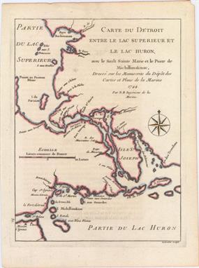
Bellin, Jacques Nicolas 1744 Carte du Detroit Entre le Lac Superieur et le Lac Huron, avec le Sault Sainte Marie et le Poste de Michillimakinac... Small map of the strategic passage in the Upper Lakes system, which was so important to the colonial fur trade. Shows Lake Superior and Huron connected by the Straits of Mackinac and depicts numerous islands, forts, and missions. Adorned with a nice compass rose. Engraved by Desbruslins. 6.3" W x 8.4" H There is some minor offsetting of text from another page.

Los 132
1925 Bill Whiffletree`s Bootlegger`s Map of the United States This unique wall map spoofing prohibition is by Edward McCandlish. Filled with puns, nothing is sacred in this hilarious look at alcohol and prohibition. Many place names are plays on words, like Chi-keg-o, Albu-Corky, Fill-More, Booze (Boise), and many more (some so bad they hurt) - "The pints of the compass are Norse, Wets, Yeast, and Souse". McCandlish was a prominent illustrator for the children`s page in many newspapers in the 1920`s and 1930`s, making this parody a radical departure. A wonderful piece of Americana that beautifully captures the humor and mood of the time. Backed in linen and mounted on wooden rollers, with linen ties. 30.1" W x 20.3" H There are several cracks and small tears in the image that are supported by the linen. Moderate overall toning with several edge chips and short tears in the blank margins. Rollers are present and intact.

Los 133
1937 A Good-Natured Map of the United States Setting Forth the Services of The Greyhound Lines and a Few Principle Connecting Bus Lines "Full-color pictographic map that is filled with charming vignettes and figures. This brightly colored map is the best of a number of maps issued by Greyhound in the 1930s and 1940s, the heyday of bus transportation in the US. The Greyhound bus routes are delineated in bold black with the interconnecting routes in dotted line. Small pictographs highlight the attractions throughout the country and most are accompanied by humorous text including “thar`s room in Texas for all of Yurrup and half of Africa, yes suh” and in Nebraska, “no use making a pig of yourself, get out there an` give a lady a chance.” The title cartouche is bounded with two vintage Greyhound buses. The map is further embellished with a fancy legend cartouche featuring the sleek greyhound associated with the business, and a large compass rose and fleur-de-lys in the Atlantic. The map is in the style of Jo Mora. There is no artist attribution, but there is a monogram at lower right with a “K” followed by the delta symbol. Printed by Sunset Press." 29.3" W x 19.5" H Issued folding in vivid color with a couple of faint spots in title cartouche.

Los 148
Blaeu, Willem 1662 Nova Belgica et Anglia Nova This important map, first issued in 1635, is one of the first to focus on the Dutch colony in North America and to name "Nieu Amsterdam" (New York). It is based on the manuscript of Andriaen Block (1614), a Dutch fur trader, who explored the area between Cape Cod and Manhattan and was the first to correctly delineate the longitudinal scale of the coastline and establish Manhattan as an island. The colony of "Nieu Pleimonth" is identified, as well as other English names along the coast, which were derived from Smith`s map of New England in 1616. The map is oriented with north to the right and is richly adorned with a variety of wildlife, including the first appearance of beavers, polecats and otters on a printed map. Quebec is noted with a minute depiction of the fort and buildings, and the mythical kingdom pf "Norumbega" is noted near the" R. Pentagouet " (Penobscot River) in present-day Maine. A large Mohawk village is shown derived from the White-de Bry engravings. It is further embellished with a large title cartouche flanked by two natives, sailing ships, canoes, and compass roses. Latin text on verso. 19.7" W x 15.2" H A fine impression with wide, original margins, light show-through of text on verso, and a number of tiny worm holes along centerfold that have been professionally infilled with a small amount of image in facsimile. There are some small chips and tears in blank margins that have also been professionally repaired.

Los 151
Kitchin, Thomas 1778 A Map of the Colony of Rhode Island: with the Adjacent Parts of Connecticut, Massachusets Bay. &c. A scarce small map of Rhode Island extending north to Boston and Boston Harbor, and south to Long Island, New York. Martha`s Vineyard and Nantucket Island are depicted, along with the roads, towns and rivers in the region. The map illustrates a major theater in the war for American independence following France’s recognition of the United States. American and British forces had been at a standoff at Newport since the beginning of the war. News of the French involvement rallied support for the cause, and militia began streaming into Rhode Island from the adjacent colonies. Several small conflicts culminated in the Siege and Battle of Rhode Island on August 29, 1778. The map is adorned with a decorative title cartouche and compass rose. 9.5" W x 7" H Issued folding with a few tiny tears and light soiling in blank margins.

Los 153
Merian, Matthaus 1627 Virginia - Erforshet und Beschriben durch Capitain Iohan Schmidt "John Smith`s map was the most important map of Virginia and the Chesapeake Bay of the seventeenth century. It was the prototype map of the region and was instrumental in creating interest in the new Virginia colony. The map depicts a number of explorations and observations made by Smith and the Jamestown settlers, with small crosses marking the range of those explorations. The information on the locations of the Indian tribes and villages is very extensive; in fact it is still in use by archaeologists today. The engraving is adorned by a decorative and functional thirty-two point compass rose placed in the Atlantic at lower left, and is a good example of a transitional compass rose. The rhumb lines extend from the compass, but only as far as the coastline so as not to interfere with the more useful depiction of topography and settlements. Eventually, land maps would phase out the use of compass roses. The other decorative elements that fill the map, including Powhatan`s Council and a Susquehannock Indian, are based on John White`s drawings made during the first attempt to form a colony in Virginia (present-day North Carolina), as published in the first part of Theodore de Bry`s “Grand Voyages”. This third derivative of Smith`s map accompanied the 13th part of the “Grand Voyages”, which was published posthumously by his son-in-law, Mathaus Merian. “Provenance”: This example was featured in conjunction with the British Museum`s collection of John White watercolors entitled “A New World: England’s First View of America from the British Museum,” during the exhibit`s travelling exposition at the North Carolina Museum of History from October 2007 to January 2008." 14" W x 11.3" H A very attractive example on a clean sheet of watermarked paper with a few tiny spots of excess watercolor in the image.

Los 162
Hondius, Jodocus 1619 Virginiae Item et Floridae Americae Provinciarum, Nova Descriptio This stunning map was compiled from two of the most important source maps of the early colonial period: John White`s Virginia and Jacques le Moyne`s Florida. Hondius` map became the prototype map of the region for the first half of the 17th century and continued to influence the cartography of the region until the middle of the 18th century. Largely due to the enormous success of Hondius` "Atlas", Le Moyne`s erroneous depiction of a large inland lake ("Lacus aquae dulcis") from which the "R. de May" (St. John`s River) flows in a southeasterly direction was popularized. Chesapeake Bay, here called "Chesepioock Sinus", and the area south towards "C.S. Romano Hispanis" are shown in their White delineations. The Indian villages of "Paquiwok, Croatoan", and "Wococon" are named in the Outer Banks and several others along the Albemarle and Pamlico Sounds. The map is extensively decorated with depictions of Indian villages incorporated in the title cartouche, a Floridian king and queen and Virginian natives in a canoe taken from De Bry, wildlife including a wild turkey, ships, sea monsters and a superb compass rose. French text on verso, published in 1619. 19" W x 13.5" H Attractive original color with wide margins, archivally repaired centerfold separations confined to top and bottom blank margins, and a few small spots in image. This is very nearly and "A" example.

Los 165
Bellin, Jacques Nicolas 1764 Carte de la Nouvelle Georgie This uncommon small map depicts the coastline from St. Augustine to St. Helena Sound and inland as far as Augusta. The boundary between Georgia and Florida is shown as of 1738. There are only a few settlements and one road connecting Augusta, Savannah, and St. Augustine. Simple title block and fine fleur-de-lis topped compass rose are the only embellishments. 5.9" W x 8.4" H A nice impression with generous margins and a slight amount of printer`s ink residue.

Los 205
Weld, Isaac 1800 Plan of the City of Washington This is a reduced and simplified version of Ellicott`s plan of 1792. Washington is bordered by the "Potomack" (Potomac) River and the Eastern Branch, now the Anacostia River. Georgetown, at the left and northwest of Rock Creek, is separately labeled. Reedy Branch and Tiber Creek are shown to the north outside of the street pattern. A few major buildings including the Capitol and "Presidents House" are labeled; others are merely outlined. The proposed landscape design for the Mall is shown with some detail. Near the upper right is an eight-pointed compass indicator surmounted by a fleur de lis. Engraved by Carl Jattnig. 8.6" W x 6.7" H Issued folding with some faint stains primarily in the blank margins.

Los 229
Kitchin, Thomas 1756 A Map of the Eastern Part of the Province of New York; with Part of New Jersey, &c. Drawn from the Best Authorities Interesting, small map depicting the main theater of the "French and Indian War" during the first year of the conflict. The region depicted includes the Hudson River valley, north to Lake Champlain, including Forts Ticonderoga and Frederick. Also shown are the Mohawk River and the waterways from the upper Hudson to Lake Ontario. The western parts of the New England states are shown, as is northern New Jersey, and northeastern Pennsylvania. The border between New York and Pennsylvania is shown considerably north of the present-day boundary. A note states that "Pensilvania is not yet settled" with much of the region labeled the " Endless Mountains." Indian tribal and hunting lands are noted, as well as roads and "Trading Paths". Inset is a tiny plan of "Fort Frederick at Crown Point built by the French in 1731", with its own tiny compass rose and scale of feet. This important French fort had been captured by the British the previous year. Decorative landscape cartouche and delicate compass rose embellish the map. A historically important map. 8.6" W x 6.7" H A sharp impression on watermarked paper, issued folding, now pressed flat, with fold separations that have been closed on verso with Japanese tissue. There is faint offsetting from an opposing page of text on the far left.

Los 258
Kitchin, Thomas 1778 Carte du Mexique ou de la Nouvelle Espagne ou l`on Peut Suivre les Mouvemens des Costes This is a French version of Kitchin`s "Mexico or New Spain in which the Motions of Cortes may be traced". It covers the region from "Louisiane" to "Nouvelle Albion" and all of Mexico except the Yucantan peninsula. The region of present-day Arizona and New Mexico is well delineated with numerous Indian villages and the locations of missions. The area from New Mexico to Louisiana is labeled "Grand Espace de Terre inconnue" (Great Space of Land Unknown). An inset shows Mexico City on the large Lake of Mexico. Finely engraved by Benard with a decorative title cartouche and compass rose. 15" W x 11.2" H Issued folding with some faint damp stains confined to the lower blank margin. Professionally remargined at right with period-correct paper.
Los 267
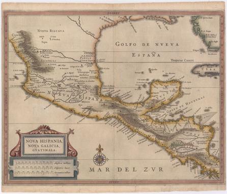
Gerritsz/De Laet, 1625 Nova Hispania, Nova Galicia, Guatimala This fine map is the work of Hessel Gerritsz, one of the most important Dutch cartographers of the 17th century. Most of his work exists only in manuscript and these maps, published by De Laet, are the only Gerritsz maps available to the collector today. The map includes Mexico through Costa Rica with considerable detail. The large strapwork cartouche incorporates the title and distance scales and the map is further decorated with a lovely compass rose. 14.2" W x 11.2" H A nice impression on watermarked paper with archival repairs to a 1/2" tear in Pacific and several short marginal tears, only one of which enters map border at bottom. Very narrow side margins, as issued.

Los 268
Jansson, Jan 1638 Nova Hispania, et Nova Galicia Decorative map of the central and western coastal regions of Mexico, based on Ortelius. Mexico City is situated on a large lake below the elaborate title cartouche featuring the Royal Spanish Arms. Several gold and silver mines are located in the central region. A galleon and sea monster ornament the Pacific and armadillos walk across the scale of miles cartouche. This is a superlative example of Dutch cartography and a great example of the similarity between the work of Jansson and Blaeu. Here Jansson`s plate features a ship and sea monster with calligraphy in the Pacific, whereas Blaeu`s map lacks the calligraphy and embellished the area with two ships and a compass rose. Latin text on verso. 18.9" W x 13.7" H A dark impression on watermarked paper with old color. There is some printer`s ink residue, a couple of minor printer`s creases, and a few tiny abrasions. There are a few tears confined to blank margins, far from map.

Los 271
Wit, Frederick de 1675 Novae Hispaniae, Chili, Peruviae, et Guatimalae Littorae This handsome sea chart focuses on Central America and the Pacific coast of South America extending to include northern Chili. It also includes part of the Caribbean with the Yucatan, Jamaica, the Caymans and parts of Cuba and Hispaniola. The magnificent title cartouche is filled with allegorical figures and the chart is embellished with rhumb lines, a fleet of galleons and two compass roses. 22" W x 19.2" H Lovely original color on watermarked paper with some offsetting and two small cracks caused by the oxidation of the green pigment that have been closed on verso with archival tape.

Los 290
Thomson, John 1816 Island of Cuba This attractive map of Cuba also shows the Great Bahama Bank and the Bahama Channel. Depicts Havana, principal harbors, points, shoals, and topography through hachure. Decorated by a simple compass rose and distance scale in British miles. 23" W x 9" H There is some soiling, offsetting and a short centerfold separation at bottom. Remargined at top with neatline skillfully replaced in facsimile.

Los 297
Kuffner, Paul 1777 Caraibische Inseln This scarce map was published in the second part of Oldendorp`s "Geschichte der Mission der Evangelischen Brueder auf den Caraibischen Inseln St. Thomas, St. Croix, St. Jan…" or a "History of the Evangelical Brethren on the Caribbean Islands of St. Thomas, St. Croix and St. John". The book is considered the first published work detailing the history, resources and social conditions in the Danish West Indies, today`s Virgin Islands. The map details the islands from most of Hispaniola through Puerto Rico, the Virgin Islands and down the Windward and Leeward Islands to include Trinidad and Tobago. The map is embellished with a compass rose and scroll-style title cartouche. Engraved by Kuffner in Nuremberg. 13.8" W x 12.1" H Issued folding, now pressed, on watermarked paper with one tiny hole at a fold intersection that has been professionally repaired. An excellent impression with a few small spots in image and a professionally repaired chip at bottom left that does not affect image.

Los 301
Moll, Herman 1729 The Island of St. Christophers alias St. Kitts Handsome map of this Leeward island with detail of cities, towns, roads, forts and plantations. A small cartouche at bottom left gives a brief description and history of the island. Title in block style cartouche with a nice compass rose and rhumb lines. This example was published in Dublin by George Grierson, circa 1733. 10.7" W x 7.9" H Issued folding, now pressed, on watermarked paper with light soiling.

Los 310
Homann Heirs, 1759 Insula Antegoa ad Fidem Prototypi Londinensis Designata et Excusa This map was copied from the work of Herman Moll in 1729. It is meticulously detailed with a compass rose, soundings, anchorages, navigational hazards, roads, churches, landowners` names, windmills, forts, and sugar plantations. This small map was trimmed from a folio map that featured five maps of the region. 11.1" W x 10.3" H Remargined on all four sides with a portion of the border in facsimile and a few very faint spots.

Los 317
Bry, Theodore de 1592 Americae Pars Magis Cognita Focusing on the Spanish possessions in the Americas, this map covers what is the present-day southern United States through South America. It was published to accompany the accounts of the voyages of Johann van Stadden and Jean de Lery. The cartography is drawn from de Bry`s own map of Florida and the West Indies after Jacques le Moyne. However, there is no easily discernible source for the South American cartography, with its southern regions shown too broad, but not quite bulging as with the Ortelius version. De Bry`s extraordinary engraving skill and artful style are very evident with the large elaborate cartouches, coats of arms, two compass roses, sea monster, Spanish galleon and intricate border. 17.4" W x 14.3" H Issued folding with a 3/8" hole at the fold intersection at bottom center and a few adjacent tiny tears that have all been professionally repaired. There are several printer`s creases at bottom and two spots just below the equator -- in Brazil and off the coast of Peru. Two tiny worm holes in image have been professionally infilled. Trimmed close the neatline at right, apparently as issued, and trimmed to the neatline at bottom left. Remnants of hinge tape on verso.

Los 326
Montanus, Arnoldus 1671 Venezuela cum Parte Australi Novae Andalusiae Beautifully engraved map based the Hondius/Blaeu map of the region, which was in turn based on the cartography of the important Dutch cartographer, Hessel Gerritsz. The map concentrates the detail along the coastlines with the interior graphically engraved to show mountains, forests and rivers. The superb title cartouche is surrounded by Neptune, explorers and maidens, and the distance scale cartouche is surrounded by natives and animals. The sea is embellished with a compass rose, rhumb lines and ships. 14.3" W x 11.3" H A nice impression on watermarked paper with light soiling and a printer`s crease adjacent to centerfold. A small chip in bottom right corner has been professionally repaired, not affecting map.

Los 328
Blaeu, Willem 1643 Guiana sive Amazonum Regio Blaeu`s beautiful map of Guiana covers the coastline from the Isla Margarita in the northwest to the coast of northern Brazil near Sao Luis east of the Amazon delta. At center lies a large inland sea, "Parime Lacus"; on its northwestern shore is the fabled city "Manoa del Dorado", or the golden city of the Incas. The search for this city led many explorers, including Sir Walter Raleigh, on wild adventures through the jungles. The map is beautifully decorated with three cartouches, ships engaged in a sea battle, a sea monster, and a fine compass rose. French text on verso, published between 1643 and 1650. 19.6" W x 14.8" H There is minor toning along the centerfold and faint scattered foxing in the image.

Los 338
Tirion, Isaac 1769 Kaart van de Aller-Heiligen Baay waar aan de Hoofdstad legt van Brazil This is a boldly engraved chart of the bay at Salvador (Bahia) with an inset plan of the fortified city of San Salvador. Navigational soundings and shoals are identified in the bay. Numerous plantations and sugar mills are noted with symbols along the coast and rivers. There is a large decorative rococo-style title cartouche and two compass roses. 15.8" W x 13.5" H Clean and bright example with one tiny hole that is only visible when held to light and has been reinforced on verso with old paper.

Los 342
Hondius/Blaeu, 1635 Peru Beautifully engraved map based on the cartography of Hessel Gerritsz. The map covers the Pacific coast of South America from Ecuador as far south as the Atacama Desert in the northern reaches of Chile. It includes the Potosi silver mines, Titicaca, Cusco, Quito and numerous other towns and villages. The dramatic strapwork cartouche incorporates both the title and the distance scales. A large compass rose orients the map with north to the left. It is further decorated with four Spanish galleons and three sea monsters. This is one of the plates that Blaeu acquired from the widow of Jodocus Hondius in 1629. French text on verso. 19.4" W x 14.9" H Original color on bright, watermarked paper with wide margins. There are professional repairs to a short centerfold separation and to a small hole to the right of the compass rose.

Los 343
Montanus, Arnoldus 1671 Peru This attractive map covers Peru with parts of Ecuador and northern Chile. Dense with place names and topographical detail, it provides a marvelous view of the region. The map is oriented with north to the left although the compass rose incorrectly depicts north at top. The decorative title cartouche features natives and exotic fauna (llama, armadillo, snake, and a strange lizard) and the distance scale is ornamented with merfolk and military banners and flags. Galleons and a sea monster complete the lavish composition. 13.8" W x 11.4" H A nice impression with isolated foxing and a tear entering 1.75" into the neatline at left that has been repaired on verso with old paper.

Los 352
Jansson, Jan 1653 Tabula Magellanica, qua Tierrae del Fuego, cum Celeberrimis Fretis a F. Magellano et I. le Maire Detectis Novissima et Accuratissima Descriptio Exhibetur This is one of the most elaborately decorated maps to focus on the tip of South America with the Strait of Magellan and Le Maire Strait. The coastlines are depicted as very mountainous, while the interior is completely without detail. Instead the region is filled with a hunting scene, exotic birds including rheas and penguins, and a quaint scene of village life. The map is further adorned with a pair of compass roses, three sailing ships, and four beautiful cartouches. The cartouches at top contain the map key and a dedication to Gualthero de Raet with his coat of arms. The cartouches arrayed across the bottom of the map present a unique distance scale in checkerboard format and the title with a tribe of Fuegian natives, penguins and shells. Spanish text on verso. 20.8" W x 16.1" H A nice impression with light soiling and two archivally repaired tears that enter 2" and 4" into map at left. There are a few small chips and tears in blank margins that have also been archivally repaired.

Los 354
Moll, Herman 1740 A Map of Chili, Patagonia, Part of La Plata &c. Detailed copper engraved map of the southern tip of South America with Tierra del Fuego, Le Maire Strait, and a partial outline of the Falkland Islands. Decorated with a simple block style title cartouche and a compass rose. 6.9" W x 10" H Moderate toning with light offsetting from an opposing text page.

Los 356
Bonne, Rigobert 1788 Detroit de Magellan, avec les Plans des Principaux Ports, Bayes &c. de ce Detroit This is a very detailed chart of the Straits of Magellan that displays the best route through the straits. There are sixteen small inset maps of the area showing anchorages and navigational hazards. The chart is centered on a large compass rose and fleur-de-lis. Engraved by Andre. 13.6" W x 9.2" H Watermarked paper with a few light spots and a professionally repaired centerfold separation in bottom blank margin.

Los 358
Bellin/Van Schley, 1746 Carte de l`Ocean Meridional Dressee pour Servir a l`Histoire Generale des Voyages... This attractive chart of the South Atlantic is centered on a large compass rose with rhumb lines radiating across the ocean. A good portion of the coastlines of South America and Africa are shown with major port cities named. The Prime Meridian is shown through "l`Isle de Fer" and the Meridian of Paris is shown just west of the coast of Africa. A large rococo title cartouche graces the otherwise blank interior of South America. Dutch title below map: "Kaart van de Zuid-Zee, om te Dienen Voor de Historische Beschryving der Reizen." 17.7" W x 13.4" H A fine impression with attractive color on watermarked paper. Issued folding, now pressed with minor printer`s ink residue, just a hint of toning, and one tiny fold separation.

Los 360
Kircher, Athanasius 1682 Situs Insulae Atlantidis, a Mari olim Absorptae ex Mente Aegyptiorum et Platonis Descriptio This "mythical map of Atlantis" is printed with north at the bottom, leaving the coast of America to the right, and Africa and Spain on the left. The Island of Atlantis ("Insula Atlantis") is a huge land mass which occupies a majority of the Atlantic Ocean. Two mountains and six rivers are depicted within the island, otherwise the interior is blank. The map is embellished with a fully ruled sea, a two masted sailing ship at upper right, a curtain-style cartouche and a simple compass rose. From Kircher`s masterpiece, "Mundus subterraneus" (The Underground World) which was the first serious effort to describe the physical makeup of the earth, proposing theories (sometimes fantastic) in the areas of physics, geography, geology, and chemistry. Published in a Dutch edition of Kircher`s famous "Mundus subterraneus" by Johann Waesberger. On a full sheet of Dutch text measuring 9.4 x 14.5". 6.3" W x 4.1" H Marginal soiling.
![1831-81 [Lot of 2] Chart of the Atlantic Ocean. With an Illustration of the Character and Rout of a Storm Which Occurred on t](http://lot-images.atgmedia.com/SR/36385/2893812/363-2013117141937_468x382.jpg)
Los 363
1831-81 [Lot of 2] Chart of the Atlantic Ocean. With an Illustration of the Character and Rout of a Storm Which Occurred on the American Coast in August 1830 [and] Atlantic Ocean &c. Shewing the Communication Between Europe, North America and the Pacific "A. “Chart of the Atlantic Ocean. With an Illustration of the Character and Rout of a Storm Which Occurred on the American Coast in August 1830”, by Edmund and G.W. Blunt, dated 1831, hand color (12.4 x 7.5”). This uncommon chart of the Atlantic Ocean stretches from eastern North America, the Caribbean, and the northern tip of South America to Portugal, Spain, and a portion of Africa. The Gulf Stream is featured, and a key explains the different types of arrows used to depict varying winds and currents. A few notes chronicle the hurricane season of 1830 by pointing out the date and location of the storms. A compass rose with a fleur-de-lis radiates rhumb lines in the chart`s center. Condition: Issued folding, now pressed flat, with a few abrasions, two of which have been reinforced on verso with archival tape, some extraneous creases, and a few short fold separations in the bottom blank margins that have been repaired on verso with archival tape. (B+) B. “Atlantic Ocean &c. Shewing the Communication Between Europe, North America and the Pacific”, by A. & C. Black, circa 1881, printed color (15.1 x 10.5”). Interesting chart that shows transatlantic telegraph cables, the Gulf Stream and other currents, and a network of travel routes across the Atlantic, with notes on distance, duration, and type of transportation. Within the United States, railroads and proposed railroads are shown. Condition: Three chips in the blank margins that have been closed with archival tape on verso. (A)" #VALUE! See description.
-
36562 Los(e)/Seite